


Contact information
Related objects
| Photo | Name | Description |
|---|---|---|
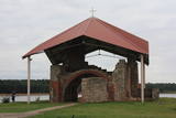 |
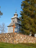
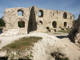
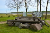
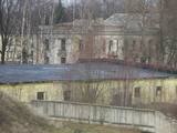
Since the 1970s, these ruins have been on a small (100 m long) island that is part of the reservoir of the Rīga hydroelectric power plant. The island is named after St Meinhard and the ruins are part of the oldest stone building in Latvia. Work on the church began in 1184, but it was rebuilt and sacked several times, most recently in 1916. The ruins have been conserved and are protected by a metal cover. The shores of the island have been strengthened. The 10 metre metal cross on the island was designed by E. Samovičs, while the stone altar was sculpted by J. Karlobs. |
|
 |
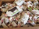
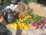
Aromatic coffee is produced here from chicory and on the basis of ancient recipes from grandma Alīda. All of the ingredients come from surrounding fields and forests. Roasted chicory coffee PAULĪNE (rye, chicory, carrots, acorns); roasted rye, chicory, and hemp coffee SĒLIJA (rye, chicory, carrots, hemp leaves); rye malt, chicory, and hop coffee VIESĪTE (rye malt grains, chicory, hops). Produce can be purchased.The owner will offer you a tour, during which you will be able to taste and buy her coffee. |
|
 |
A memorial room to Janis Jaunsudrabins in Kaplava *Object Inactive*

|
Jānis Jaunsudrabiņš (1877-1962) was a Latvian writer, painter and book illustrator, and he was one of Latvia’s first art critics. The writer spent two years in Kaplava, where his experiences led to the novel “Highlanders.” There is a memorial room in Kaplava, and alongside the building is a memorial stone. |
 |
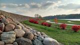
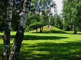
This is the oldest arboretum in Latvia. It was planned by the owner of the Skrīveri Estate, Maximmilian von Sievers (1857-1919). It has to be said that before World War I, there were two times more species of plants in the park than is the case now. The plants are grouped in accordance with the geo-botanic regions of the world. There are trails in the park, and signs showing the Latvian and Latin name of each plant are there, as well. There’s a fountain which is operated from every hour on the hour from 11:00 AM until 11:00 PM from Tuesday until Sunday. On the other side of the Rīga-Daugavpils highway is the Skrīveri Forest Park with hiking trails.
|
|
 |
The café is on the banks of the Daugava River between Stukmaņi and Pļaviņas, offering a bakery, shop and café. There are dozens of types of bread, biscuits, tortes, cakes and other baked goods. Latvian cuisine: Dumpling or sorrel soup, farmer’s breakfast, eggs sunny side up, pork ribs, grey peas, potato pancakes with salmon, crepes, blackberry crème. Special foods: Liepkalni rye bread, bread kvass.
|
|
 |
Found on the right bank of the Daugava where the little Karikste river flows into the Daugava, all that remains of the castle today is a set of ruined walls and foundations. The castle was built by the Livonian Order in 1224, and it was inhabited until the mid-17th century, when it was sacked during the Polish-Swedish war. The ruins offer a good view of the local gravel road that goes along the right bank of the river valley.
|
|
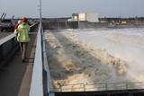 |
This is Latvia’s first major hydroelectric power plant, and construction along the right bank of the Daugava began in 1936. The plant was designed by the architect Eižens Laube. The first hydro-aggregate (17 MW of capacity as the largest plant in Latvia) was switched on in 1939. A second round of construction occurred between 1976 until 1979, the result being a new building on the left bank of the Daugava, increasing the capacity of the plant to 260 MW. Another round of reconstruction occurred between 1998 and 2001 on the left bank of the Daugava (the HES-2 plant). The Energy Museum is now there.
|
|
 |
The central part of the town of Krāslava is an historical monument because its low-story and beautiful wooden buildings. The best views of the historical centre relate to the carp park near the Adamova trail, the Karņicskis hill, the bridge across the Daugava (Prospekta Street), and the Priedaine viewing tower on the left bank of the Daugava River. |
|
 |
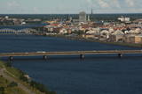
Krustpils was first recorded in documents in 1237 in relation to the construction of the Kreutzburg castle on the right bank of the Daugava River. A 1511 document lists it as a village. In 1585, Polish King Stefan Báthory gifted the town to Nicholas Korff, whose family continued to own it until 1920. Battles between Swedish and Polish forces occurred outside of Krustpils in 1626, and the sacked village was in poor shape until the mid-19th century. Jēkabpils, in turn, was constructed as a settlement for Old Believers who were persecuted in Russia. The Daugava has rapids opposite Krustpils and Jēkabpils, which means that boats had to dock there and reload their goods into wagons. The settlement flourished, and in 1670 it was given the rights of a city. It is named after Duke Jacob. When the Rīga-Daugavpils rail line opened in 1861, Krustpils flourished, and Jēkabpils did not flourish. The two cities were administratively merged in 1962, keeping the name of Jēkabpils. There are typical one-story wooden buildings from the 19th century, red brick buildings built at the turn of the 20th century, as well as seven churches used by different denominations. The dam along the left bank of the Daugava was built in 1861, and it was aimed at protecting the city against flooding. Today it is a promenade that is popular among local residents for strolling and leisure. |
|
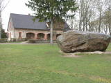 |
The museum is in the Lielvārde Park. It is in the granary of the Lielvārde Estate that was built in the early 19th century. It was later used as a residential building. A veranda was added to it in 1922. The museum has been there since 1970, and it features exhibits about the Latvian national epos “Lāčplēsis” and its author, Andrejs Pumpurs (1841-1902). The museum also features information about the history and ethnography of the Lielvārde Administrative District. Alongside it is a large rock that weighs around 80 tonnes and is known as Lāčplēsis’ Bed. A broken part of the rock is known as the Lāčplēsis blanket. Both rocks were once on the banks of the Daugava River next to the Lielvārde island. Waters from the Ķegums hydroelectric power plant now make waves in that area. Nearby is the so-called Spīdala log that was brought from Aizkraukle.
|
|
 |
The family enterprise (formed in 2006) makes home-made ice-cream from fruit and berries. They make both classical – such as plombieres, cream, joghurt ice-creams and sorbets and nowadays cuisine’s „miracle”- sprat, blue cheese, horse-radish and potato ice-cream with tomato sauce. Till now 80 different ice-cream recipes have been tried. If you book a visit beforehand, you can have an excursion and learn everything about the process of making ice-cream from the chefs themselves. In the cafe it is possible to try different ice-cream dishes – each one with a different ice-cream sauce. The cafe also welcomes pets! Special foods: Horseradish ice cream with herring. |
|
 |
A wooden church was built by local craftsmen here between 1655 and 1658. Financed by the Plater aristocratic family, it was a miniature basilica, and this is seen as one of the oldest wooden churches in Latgale. That makes it a unique cultural and historical monument. The central altar has baroque wood carvings that were produced by masters from a local sculptural school. The side altar includes a painting of Mary Magdalene from the mid-18th century. The church was moved to its present location on the right bank of the Daugava in 1698. It has been restored several times – in 1890 and 1918. The stone wall that stretches around the church dates back to the late 17th century, and the freestanding bell tower was built in the mid-19th century. It was restored in 2002. According to various sources of information, the Indrica congregation is the oldest one in Latgale. |
|
 |
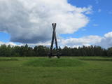
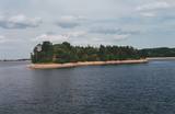
This was an island after the Rīga hydroelectric power plant created a reservoir, and before that it was a peninsula on the Left Bank of the Daugava. During World War I, there were massive battles between Latvian Riflemen and a much larger German army on Death Island. On December 25, 1916, the Germans used poisonous gas against the Latvian troops. In honour of this, the architect Eižens Laube designed a monument to fallen Latvian riflemen on the northern shore of Death Island. It was unveiled in 1924. Death Island can be reached by boat, and the trenches and graves there are of interest. There is a pier for boats on the north-western shore of the island, and nearby is a location for leisure. Some of the trenches and dugouts have recently been restored. The battles were described by Aleksandrs Grīns in his masterpiece, “Snowstorm of Souls.” |
|
 |
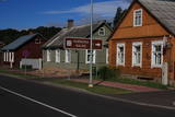
An ancient Latgalian settlement. During the 10th century Kraslava district was under authority of the Prince of Polotsk, but the 13th century - under the authority of the Livonian Order. Until the beginning of 18th century it existed as a manor centre. In 1729 Kraslava was bought for 1400 thalers by Johan Ludvig Plater. Plater family ruled Kraslava for two centuries. In the of the18th century Platers began construction of Krāslava palace. After first division of Poland in 1772 Latgale was annexed to Russia. Kraslava began to perish. After construction of Riga - Daugavpils - Vitebsk railway (1865) economic life flourished again. Kraslava was little affected by the World War II, therefore, early wooden buildings of 20th century remained almost untouched. |
|
 |
The castle hill is an island in the reservoir of the Pļaviņas hydroelectric power plant, and it can be accessed by boat. The ancient Selonian castle hill was settled several times between the 6th and the 12th century. This was the political and military centre of the Selonian region. In 1373, the Livonian Order built a stone castle on the hill, as it did on many other ancient hillocks. The castle was sacked in 1704 during the Great Northern War. Remnants of a square tower, a guard room and the 12 m embankment that once protected the castle are all that survive. Approximately 300 m to the North of the Sēlpils castle hill is Oliņkalns hill, which is underwater. |
|
 |
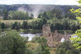
The ruins of the Koknese Castle are found where the Daugava and Pērse rivers flow together. The castle, which is on a floodplain, was built for the bishopric of Rīga in 1209, and it replaced an ancient Latvian castle that was made of wood. The castle was blown up by Saxon forces in 1701. A visitors centre is near the ruins, and there you can carve a Medieval coin or rent a boat to sail down the Daugava. Make sure to stroll through the Koknese park, which is alongside the ruins. |
|
 |
This venue organises seminars, courses and activities related to Latvian holidays and family celebrations. There are master’s classes about culinary heritage in
|
|
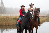 |
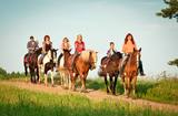
The farm features twelve friendly horses from Latvia, Lithuania and Belarus, as well as three eager dogs of various species, along with rabbits, chickens, cows and cats. Here you will feel the true country spirit in four adjoining farms – Klajumi, Ganiņi, Ķemeri and Krasti. The location is near the “Rings of the Daugava” Nature Park, and you can go horseback riding along the border between Latvia and Belarus. Latvian cuisine: Schnitzel of mushrooms, potato dumplings with dried mushrooms or meat, cream sauce and onions, baked chanterelles with new potatoes, sautéed vegetables and mushrooms, strawberries with ice cream, moonshine liquor. Special foods: Cranberry fool a la Klajumi |
|
 |
The rock is along the main street of Krāslava and is found at Augusta Street 12. After major reconstruction of the city’s infrastructure, the rock was successfully integrated into the surrounding landscape. The rock is 2.8 m long, 2.2 m wide and 700 cm high. It once served as a border stone for the village of Krāslava. It was placed there in 1729 to commemorate the day when the noble Plater dynasty bought Krāslava. The dynasty’s seal is engraved in the side of the rock along with the date when it was installed. Legend has it that Polish King Augustus II dined at the rock after a hunt, and that is why it is known as Augustus’ Rock. |
|
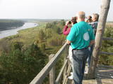 |
The old wooden tower at this site was torn down and replaced with the one that is there now. The restored tower offers one of the loveliest views in Eastern Latvia – one of the eight curves of the Daugava. This is the Rozališki curve. Here you will get a whole new sense of the Daugava River and its mighty valley in a place where the waters of a hydroelectric plant bubble away in our present day and age. It is claimed that the scene that is seen on the 10 lats note is based on the view which can be seen to the West from the tower. |
|
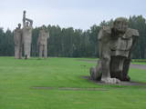 |
A Nazi concentration camp was at this location during World War II, and there is information to suggest that more than 50,000 residents of occupied Europe were murdered here. This is one of the largest ensembles of its type, taking up 25 hectares of land. It was opened in 1967 and has large groups of sculptures, including “Mother,” “Solidarity,” “Unbroken One” and “The Path of Suffering.” The wall of the entrance gates has a thematic exhibitions. |
|
 |
Materials of archaeological excavations show that the Ogre river banks were inhabited by the Livs. Ogre as a larger populated area and a major resort developed after the construction of Riga-Daugavpils railway in 1861. Until the World War I about 300 cottages offered their services in Ogre, most of them were destroyed during the war. The next "major" event took place 1965 when one of the largest knitwear plants in Europe was built in Ogre, which was staffed by guest workers from Vietnam and countries. Today, Ogre has still not recovered its glory of a resort, but has become a rather exclusive site of mostly low-rise residential buildings. |
|
 |
This is the highest point in the southern part of Daugavpils. A radius of approximately 300 m around 18. Novembra Street once housed the first Old Believer prayer house (1908-1928), the St Boris and Gleb Orthodox Cathedral (1905), the Daugavpils Mother of God Catholic Church (1905), and the Daugavpils Martin Luther Lutheran Church (1893). |
|
 |
To the south of Koknese, the Destiny Garden is on an island that is surrounded by the waters of the Pļaviņas hydroelectric power plant (there is a bridge to the shore). The aim of this fundamental open-air object was to commemorate people in Latvia who suffered because of totalitarian regimes. The first work here began in 2008, and the designer of the landscape was a Japanese landscape architect, Shunmyo Masuno. Work on the garden continues, but it is already a popular tourist destination. The first permanent structure is a terrace that offers a view of the Koknese castle ruins and the local Lutheran church. This means that there will be something new each time that people visit the park. People are invited to bring rocks for this nationally important location that commemorates Latvia’s history. |
|
 |
Pēteris Barisons (1904-1947) was a Latvian composer and conductor, and this is his birthplace – the Skudras homestead. The exhibition features the composer’s personal items, including musical instruments, documents and other bits of evidence about his life. Call +371-6512-9504 to arrange for a visit. |
|
 |
LIBERTU birch sap products *Object Inactive*

|
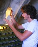
This is the only place in Latvia where you can tour a cellar in which the owner uses birch juice to prepare syrups, birch wine, sparkling wine (champagne), lemonade, and fermented birch juice. You can taste and buy the products. |
|
|
Located at Daugavas Street 58 in Skrīveri, this was the first home of the Andrejs Upītis (1877-1970). It was built in 1908, but the one that is there now was built on the foundations of the first one in 1921. The building houses a museum which features the life and work of the writer, including the writing his great novel “The Green Earth.” There is a garden around the building. In 1952, Upītis gifted the house and garden to the state. The museum offers tours and educational programmes. |
|
 |
The church is on the highest part of the banks of the Marku river, and it is behind the Piedruja border control point. A paved street leads to the church, and it is thought that it was built in the early 20th century by local farmers, who were required to bring stones for the street when they attended worship services. The church has six cupolas and is seen as one of the most beautiful ones in the Krāslava Administrative District. The building was erected between 1883 and 1885 to replace an old 17th century wooden church. It corresponds to the architectural form of the Old Russian town of Vladimir and the Byzantine style. It is said that at one time the church had as many as 1,000 members. |
|
 |
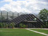
This is a modern and contemporary centre, including an old and restored granary. It offers an exhibition hall, an historical exhibition, a shop where you can purchase crafts, and a conference hall. Craftspeople from the region work here, and you watch them at work or try your own hand at what they are doing. |
|
 |
The museum was established in 1973 and has been in the Kalna Ziedi homestead since 1989. The permanent exhibition is in a building that was erected in 1989 on the foundations of the former home, while the warehouse (1990) was built on the foundations of a cattle shed. The exhibition hall (2000) was built where a granary once stood. The only part of the former farm that remains in place is the cellar, but the placement of the buildings is typical for the layout of a farm in Vidzeme. The collection of the museum speaks to the history of the administrative district, beginning with information about the Stone Age. The open-air exhibition features beehives with marks of belonging, as well as rare round crosses that are monuments to Medieval cemeteries. 100 metres to the Northeast from the museum is the Kalna Ziedi castle hill, while 200 metres to the south are the remains of a sacrificial oak stump that was destroyed in 1994. The location is on the edge of the reservoir of the Pļaviņas hydroelectric power plant and offers a broad view of the plant’s dam and the town of Pļaviņas.
|
|
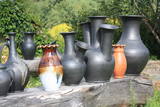 |
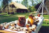
The potter is happy to welcome guests, offer them tours and demonstrations, and allow visitors to help in producing ceramics. Particularly interesting is the opening of the kiln, and pottery can be purchased at the site. |
|
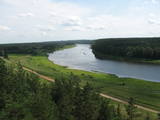 |
This nature park is one of the richest and most unusual nature parks in Latvia in terms of its natural resources, the surrounding environment, the landscapes, the biological diversity of the area, and the cultural monuments which are found there. The main treasure there is the little-changed Daugava River valley, where there are eight major curves in the river at a length of four to eight kilometres. There are also the gullies of river tributaries. Outstanding views can be found on the steep shores of the Daugava River valley, particularly the Slutiški and Ververi cliffs and the Elerne gravel hill. There are some 20 archaeological monuments on the shores of the valley -- ancient castle hills at Najene, Markova, Vecračina, etc., countless churches -- the Juzefova, Sprukti, Borovka, Elerne, Sīķele, Kaplava and other churches, the Rozališki, Lielborne and other baronia estates, and the unique village of Slutiški, which is home to the Old Believers. There are interesting nature trails and bicycling trails in the area. Horseback riding is available, and there is a viewing tower along with other elements for tourists. Boating down the Daugava River is an interesting way to spend time. |
|
 |
Not far from the Rīga ring road on the Right Bank of the Daugava is a monument designed by the sculptor Ģirts Burvis in 1994, which is dedicated to the Livs of the Daugava region and their Mārtiņsala leader, Ako, who led a battle against the Holy Crusades in 2016. Around the monument is a large area for leisure and perambulations. This is one of the loveliest locations in the lower reaches of the river. A bit further along are information stands about the history of the banks of the river before the construction of the Rīga hydroelectric power plant. |
|
 |
Klajumi is situated among picturesque surroundings of Daugavas Loki Nature park and offers accommodation in 3 cottages. Guests can enjoy horse riding facilities. The property is located 2 km from Kaplava village and 5 km from the Latvian – Belarusian border. The town of Krāslava is 10 km away. "Klajumi" holiday house. On the first floor of the holiday house there is a kitchen with fireplace, dishes and other tools necessary for cooking and eating, herbal tea and instant coffee, a fridge, radio and CD player, shower and sauna. On the second floor and in the attic there are bedrooms. Next to the cottage there is a dry toilet. "Klajumu Ķemeri" holiday house. Wooden log house with a kitchen, a bedroom, WC and shower. "Klajumu Ganiņi" holiday house. Two rooms, a kitchen, a bathroom. House is suitable for people with disabilities. |
|
 |
The National Botanical Garden in Salaspils ranks as the largest botanical garden in Latvia and in the Baltics with a territory of 136 hectares. The National botanical garden collection consists of about 14 thousand different varieties. More than 5,000 plants are found in the arboretum, as well as various other exhibitions, such as orchards, rosaries, ornamental plants. Botanical Gardens can inspire you to uprade your own garden assortment with new plant varieties and offers the experience of learning about botanical knowledge in nature. In addition, it presents opportunity to expand your personal photo archive with an exclusive background photographs and close-ups. There is a playground for children, comfortable cycling paths, nordic walking paths, picnic possibilities. |
|
 |
The largest town in South-Eastern Latvia is on the banks of the Daugava River, which is the border between Latvia and Belarus at this location. The border runs down the middle of the river. Piedruja has two parts – Piedruja and Aleksandrova, which are separated by a central street (the V 631 road). Piedruja emerged from the Druja town that was on the left bank of the Daugava. During the 17th century, the two parts were owned by the Stapekha dynasty of Lithuanian aristocrats. It is worth strolling through the town, because the low-level wooden houses are reminiscent of buildings that are exhibited in open-air ethnographic museums. Piedruja is neat and tidy, with two churches and the Daugava rock that are part of a local hiking trails. Aleksandrova has a tourist accommodation, “Piedruja,” which offers special soirées in the Lettigalian, Russian and Belarusian style. Please be aware that you need a temporary permit to enter the border zone. The Border Guard facility is in Piedruja and at a place where there was a Daugava crossing point comparatively recently. |
|
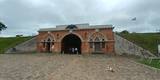 |
Found in the western part of Daugavpils and on the banks of the Daugava River, this is almost the only fortress in Northern Europe that has been preserved since the first half of the 19th century. Work on the fortress began in 1810, though it suffered much damage during the war of 1812 and because of flooding in 1829. The fortress was of strategic importance in terms of its location, not least in terms of the battle against Napoleon’s forces. It was consecrated in 1833, though construction work ended nearly half a century later, in 1878. The fort is divided up into squares, with the Parade Field in the centre of the whole fortress. After it lost its strategic importance in 1897, a warehouse was installed there. Prior to World War I, General Jānis Balodis, Colonel Frīdrihs Briedis and others served at the local garrison. In 1912, in honour of the centenary of the aforementioned war, a monument was unveiled in the park of the fortress. During the Soviet occupation, Red Army units took over the fortress, and a technical aviation school was established there. Even today, the fortress is a “city in a city.” It has a residential area, though the buildings are quite shabby. Both inside and outside the fortress are many elements that relate to military issues. Right now fundamental work is being done to reconstruct the buildings, water pipelines and streets of the fortress. The fortifications of the fortress are home to one of the largest colonies of bats in all of Latvia, and it is strictly forbidden to disturb them when they are asleep. Major restoration of the fortress has included the establishment of the Mark Rothko Art Centre. The distinguished artist was born in Daugavpils in 1903, when Latvia was still part of the Russian Empire. |
|
 |
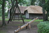
This is the farm of a moderately wealthy Selonian farmer from the 19th century. It features a residential building with a mantel chimney, two granaries, a threshing barn, a sauna, a windmill, a smithy, a steam locomotive and a threshing machine. Groups will enjoy thematic programmes such as “Crafts at the Selonian Farm,” “When Honey Melts on Your Tongue,” and “A Wedding at the Selonian Farm.” |
|
 |
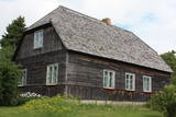
The Slutiški village is a very ethnographic village with a layout and buildings typical of the Latgale region, complete with decorated windows and facades. The Slutiški Old Believers House features a museum focusing on the cultural environment and traditions of the Old Believers. One of Latvia’s most unusual landscapes can be seen from the ancient banks of the Daugava River. |
|
 |
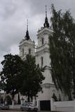
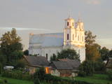
There are records to show that there has been a church at this location since the 17th century, and the current one was built between 1792 and 1794 by the chief construction specialist of the city of Rīga, Christopher Haberland. He designed the cupola-shaped building, with the cupola ensuring good acoustics inside the building. The altar is opposite the entrance door. Between the columns of the building is an altar painting showing Christ and St Peter on a storm-ravaged sea. Other important objects include chalices from the 18th or 19th century, candelabras, etc. The building was restored in 2014. To the South from it is the Katlakalns cemetery, which is the final resting place of the distinguished Baltic German writer Garlieb Merkel (1769-1850). He was of great importance in ensuring the end of indentured servitude in Latvia. |
|
 |
The Eastern breakwater was installed in the mid-19th century to reduce silt in the river valley and to regulate the flow of water. It is made of wooden pilings that are covered with rocks. The breakwater is 2.2 km long and has been rejuvenated as a popular place for hiking, leisure and fishing throughout the year. Birds can be watched from the breakwater, and sometimes people are lucky enough to spot a seal. At the start of the breakwater are two rocks with engraved text to say that the site was visited by Russian Tsar Alexander II in 1856 and by his heir, Nikolai Alexandrovich, in 1860. This points to the importance of the Rīga port in terms of Baltic Sea trade routes at that time. |
|
 |
This 368 metre structure is the highest television tower in the European Union. Its viewing area, which is at a height of 97 metres, is the highest publicly available viewing area in Latvia. The location offers a fantastic view of Rīga and Old Rīga to Pārdaugava, the Bay of Rīga and Sigulda – a radius of at least 50 kilometres.
|
|
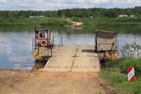 |
This is one of two crossing points across the Daugava (the other is near Līvāni). It is an exotic form of transportation to carry pedestrians, bicyclists and light automobiles across the river. There is a motor that operates a 200-metre metal cable. The crossing point is based on Soviet military pontoons that were used to build pontoon bridges for tanks. The crossing point was established by its owners. The Dunava Catholic Church is on the left bank of the river, and nearby is a monument to rafters. During the 1820s, there were three crossing points of this type across the Daugava. |
|
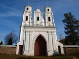 |
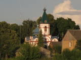
Located on the right bank of the Daugava, the church can be seen from various parts of Piedruja. The first wooden church was built at the instruction of Prince Jan Stapekha in 1632, and it burned down in 1759. The Baroque stone church that is there now was built in 1759 with its two towers, and it may have been designed by an Italian architect. The towers stand 27 m high, and under the church is a cellar. The towers have three bells – the largest one dates back to 1711, the middle-sized one was manufactured in 1896, and the smallest dates back to 1619. The largest bell weighs nearly 0.4 tonnes. Inside the church are many important cultural and historical monuments, including a central wooden altar with a painting of the assumption of Mary, three 18th century altars, a pulpit from the early 19th century, St Anton’s altar, a fresco of the Holy Trinity, church dishes from the 17th century, etc. The building is surrounded by a large garden with a stone fence and stone repositories at the corners of the garden. Two priests, Kazimirs Konvalevskis and Broņeslavs Stefanovičs are buried here. Stefanovičs played a major role in the restoration of the church after World War I. The Piedruja congregation first emerged during the first half of the 17th century. |
|
 |
The monument is on the banks of the Daugava River opposite Kaļķu Street in Pļaviņas. The symbolic raft is made of logs and stones, and around it are informational stands with photographs that tell the story of the heavy work that rafters on the Daugava once did in terms of overcoming the rapids of the river. |
|
 |
Established in 1957, this is the first company to have produced the popular milk candies “Gotiņa.” The tasty candy can be bought, and tours are available. The owner of the company is the main candy master, and he is happy to talk about the complicated method by which the candy is produced.
|
|
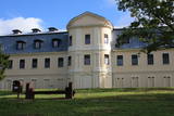 |
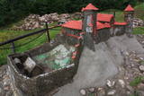
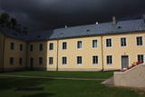
There are several buildings from the estate that survive to the present day and were built by the Plater dynasty of noblemen. The old mansion that is on the side of the Count Plater Street was built in 1759 on the banks of the Jāņupīte River. The Baroque building was designed by an architect from Venice, Antonio Parazzo. Later the mansion was rebuilt, and after a new castle was erected, the Plater family spent its summers on the first floor of the old building. The second and third floors had a library with some 20,000 books. The noblemen managed to move most of the contents of the library to safer locations during World War I, when the library as such was destroyed. Work on the new castle of the Krāslava Estate (on the upper part of the Daugava River Valley) began in 1756 (architect Domenico Parazzo). Initially it was in the Baroque style, but reconstruction at the turn of the 18th century involved Classicism. Unique Rococo wall paintings with views of Rome have been discovered in the building. These were based on samples from castles in Poland and were painted during the 1760s and 1770. A high school used the new castle until the 1970s. Then the building was abandoned and gradually turned into a ruin. More recently there has been major renovation of the castle’s façade, and it now has a good appearance. Surrounding the structure is a romantic landscape park that dates back to the mid-18th century. It is on the hillocks of the Daugava River Valley and the valleys that cross it. An artificial grotto has been restored, and a statue of a lion stands guard over the site. The stairway has been placed in its historical location, and the park features pathways and a yard. |
|
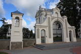 |
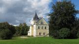
The Krāslava Catholic Church was built between 1755 and 1767 after a design by the Italian architect A. Paracco, and it is considered to be Latgale’s most outstanding Baroque monument. The interior can be toured, and you can also visit the restored cemetery where members of the Plater family of noblemen are buried. |
|
 |
The Swedish army built a modern fortress during the 1640s with five bastions and two gates. There were 120 cannons and mortar throwers, barracks for soldiers, flats for officers, a garrison church and warehouses for food at munitions. After the Great Northern War in 1710, the fortress was taken over by the Russian army. After the Soviet occupation in 1940, the Soviet navy took over the fortress. Alongside it is a former Soviet army facility with abandoned buildings and a monument to sailors who served in submarines. The fortress is open for tours on Saturdays and Sundays. |
|
 |
In the small town of Pļaviņas, at the place where the Skanstupīte River flows into the Daugava (Friendship Park), there are the remnants of a set of small and low fortifications known as the Swedish bastions. This was a place of military and political importance, because here was the place where the boundaries of Vidzeme (under Swedish rule), Latgale (under Polish rule), and the Duchy of Kurzeme (on the opposite side of the river) all came together. In 1625, the Swedes were defeated by the Poles here, and Swedish King Gustav Adolf almost lost his life. Medieval bastions of this kind can be seen in some other places of Latvia, as well.
|
|
 |
The complex dates back to the 17th and 18th century, when a fortress was replaced by a mansion and other buildings. The rectangular yard that is in the centre of the state is surrounded by the mansion, two granaries with columns that were built opposite one another, a stable and a wheelhouse. The stable and wheelhouse, the bell tower and the gate create the most impressive part of the buildings. Bells were rung because of religious rituals, but also to inform people at the estate about everyday issues. The silhouette of the building is reminiscent of cloisters, city halls and churches that were common in Europe in the 18th century. In 1780, the estate was taken over by the family of Karl Otto von Löwenstern, and the mansion can only be viewed from the outside. There is a hiking trail near the estate. |
|
 |
This is an ancient and important place for trade and craftsmanship on the left shore of the Rīga hydroelectric power plant reservoir. It rises some 15 m above the Daugava River. The Zemgale port that is described in historical documents is thought to have been located alongside the castle hill and at the mouth of the little Varžupīte stream. Antiquities that have been dug up here suggest that the castle hill and its adjoining ancient settlement were populated until the late 12th century, when the importance of Daugmale began to shrink because of rapidly growing Rīga. The foundations of the castle hill have been shored up. |
|
 |
Located in the south-eastern part of Piedruja and on the banks of the Daugava River, the rock can be accessed via the local path or a local land road. The rock was sculpted by Vilnis Titāns, who engraved the name of the Daugava River in seven languages – Latvian, Livonian, Estonian, Polish, Russian, German and Finnish. Opposite the rock is Druja, which is in Belarus, as well as a large island that splits the river in two. A temporary permit is needed to visit Piedruja. |
|
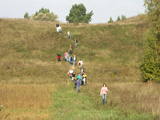 |
The Markova information trail is the most diverse and impressive trails along the upper reaches of the Daugava river in terms of objects and landscapes. The visitor will go to the top of the Markova castle hill, which offers a great view of the river valley. The deep Putāni stream valley will be crossed to get to the cliffs on the right bank of the Daugava. Here, the visitor will see one of the most unusual landscapes of Latvia’s river valleys. There is the Slutišķi village of Old Believers, along with the mighty Slutišķi cliff in the background. The trail is 1.6km long, and it will take an hour or two, particularly if the visitor chooses to tour the village and the homes of the Old Believers.
|
|
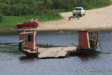 |
In the southern part of Līvāni, where Zemgales Street ends at the Daugava River, there is a fairly unusual and exotic form of transportation – one of three river crossings in Latvia. Unlike the one in Līgatne, this one is operated by a motor, not the flow of the river. It involves a cable across the river, and it is based on Soviet military pontoons that were used to build pontoon bridges for tanks. The crossing point was established by its owners. |
|
 |
Found on the right bank of the Daugava, approximately half a kilometre upriver from the Skrīveri Agricultural Institute, the hill is in a place where the bank of the Daugava River Valley is split by the deep Ašķere stream valley. The castle hill was occupied beginning in the first millennium BC, with antiquities from the Lettigalian and Livonian tribes found there. During the 13th century, a brick castle was built on the hill, but it was sacked during the 17th century. Nothing remains of the castle. The castle hill is also known as Raven Hills, and it offers one of the most beautiful views of the central part of the Daugava. In the direction of Rīga, there is a field with a white cross that represents an ancient church. There is a hiking trail along the Ašķere stream. The area is well improved with four trails. The longest is the Daugava trail (10 km). |
|
 |
Established in 1900 at the place where the Pērse River flows into the Daugava (now the reservoir of the Pļaviņas hydroelectric power plant), the park offers a look at 17th century Swedish cannons and monuments from Medieval graves. Next to the high school in the park is a restored fountain, “Head of a Faun,” which was near the legendary Pērse waterfall during the 1930s. The waterfall is now underwater, but its location is indicated by a stone sculpture, “Girl of Pērse,” which was created by the sculptor Juris Zihmanis. A path leads to an 11 metre high wooden sculpture, “For Eternity,” by the sculptor Ģirts Burvis, and another sculpture, “Little Owl,” which is the work of the Rurāns brothers, both of whom are sculptors of wooden sculptures.
|
|
 |
This is a unique example of industrial heritage – the only open munition factory in the Baltic States. It includes Europe’s oldest pellet pouring tower, and it is still used for that purpose today. Tours are available for those who contact the factory in advance, and a guide will lead groups through the factory, the tower and the museum. Today the factory manufactures nine types of bullets for smooth-barrel weapons, as well as bullets for pneumatic weapons. The products are exported to Germany and other countries. |
|
 |
This location is important in terms of Latvia’s history, because during the 12th and 13th century, this was the administrative and spiritual centre of the Lettigalian tribe, with the ruler of Jersika being Visvaldis. The castle stood on the shore of the Daugava at a height of 18 m, and this was a mighty castle hill. The flat part of the hill measured 100 x 75 m, and it was surrounded by a barrier and a defensive wall made of logs. People entered the castle via guarded gates beyond which there were residential and household buildings, as well as a small church. Archaeologists have found the remnants of log buildings, as well as many antiquities from the 10th to the 13th century that speak to extensive trade relations with other parts of Europe, including ancient Russia. In 1209, the forces of Bishop Albert fooled the people in the castle and sacked it and the ancient town that was around it. Visvaldis’ family was taken hostage, and so the Lettigalian ruler was forced to become a vassal of the bishop. The castle hill is privately owned, so please contact the owner before planning a visit. |
|
 |
From the Asote castle hill, which is on the right bank of the Daugava River near Jēkabpils, there is a fine view of the Daugava River valley, the Ābeles Island, and the Kaupre castle hill that is at the northern end of the island.
|
|
 |
The Naujene castle hill is on the steep bank of the Daugava River, is up to 25 metres high and has two valleys on its sides. Between 1275 and 1277, the master of the Livonian Order, Ernst von Ratzenburg, organised the construction of a brick castle to replace a Lettigalian wooden castle that had stood there before. The castle had a drawbridge and an external and internal forecastle. Until the middle part of the 16th century, the castle was the residence of one of the top officials in Dünaburg. The forces of Ivan the Terrible sacked the castle in 1577, after which the location lost its strategic importance. New fortifications were built in the location that is now the city of Daugavpils. Alongside the ruins of the castle is a miniature model that helps to imagine the appearance of the location many centuries ago. A well-appointed pathway leads from the car park to the castle hill. The hill offers one of the loveliest views of the curvy Daugava River and its surrounding nature park. |
|
|
|
The Slutiški village is a very ethnographic village with a layout and buildings typical of the Latgale region, complete with decorated windows and facades. The Slutiški Old Believers House features a museum focusing on the cultural environment and traditions of the Old Believers. One of Latvia’s most unusual landscapes can be seen from the ancient banks of the Daugava River. |
|
 |
The monument dedicated to the Staburags cliff was installed in 2003. Designed by the sculptress Solveiga Vasiļeva, the monument is known as “The Ear of God,” and it is installed in the place where the reservoir of the Pļaviņas hydroelectric power plant flooded one of Latvia’s most interesting geological monuments. Staburags relates to many legends and stories told by rafters. It stood 18.5 m high and was a sandstone cliff on the left bank of the Daugava River, dating back to the last Ice Age. The Liepavots stream that trickled out of the cliff is now also underwater. Staburags and the flooded Daugava quarry were once among the most popular tourist destinations in Latvia. |
|
|
|
This is a modern and contemporary centre, including an old and restored granary. It offers an exhibition hall, an historical exhibition, a shop where you can purchase crafts, and a conference hall. Craftspeople from the region work here, and you watch them at work or try your own hand at what they are doing. |
|
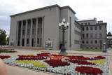 |
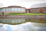
Found at Rīgas Street 22A, this impressive building was suggested by Latvian President Kārlis Ulmanis and built in 1936 and 1937 after a design by the architect Verners Vitands. It is seen as one of the most outstanding architectural monuments from the first period of Latvian independence, and it is said that it was once the most modern multifunctional building in all of Europe. The building now houses the Daugavpils Theatre, the Latgale Central Library, the Latvian Cultural Centre, the Latvian House, the US Information Centre, the Daugavpils Tourism Information Centre and other institutions. Unity Square is alongside the building, and beautiful compositions of flowers are nearby during the growing season. |
|
 |
Located in a cultural centre at Brīvības Street 15 in Ogre, the museum was established in 1980 and has a permanent exhibition, “Ogre – a Swimming and Air Spa, Relaxation and Everyday Life, 1920-1940,” which offers a good look at the “golden age” of Ogre, when it was a popular spa. Another exhibition, “Legendary Ogre” offers a different view. Visit the museum to find out what it is!
|
|
 |
The museum is in the mansion of the Dole Estate, which was built in 1898 for the Loeuwis von Menar dynasty. The collection presents Daugava as an important water route, with the apparel of Baltic and Liv tribes, everyday objects, etc. Outside the movement is equipment to catch lampreys and a reconstructed weir to catch salmon. Alongside is a 17th century cannon from the Duchy of Courland that was found in the Misa River and was cast in Baldone. Nearby are four cannons from the Russian tsar’s army. Those were found on a building lot in Salaspils in 2007. |
|
 |
The origins of the castle date back to 1237. The closed yard that was typical of Medieval castles has been preserved. The interior took on its Historicism design in the mid-19th century, but there are also more ancient elements such as the gate tower, the basic walls, the firing apertures, the vaulted structures, the window apertures, etc. The Jēkabpils Museum of History was installed in the castle in 1994, and it can be toured in the company of a guide or an audio guide. |
|
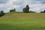 |
This is one of comparatively few castle hills along the banks of the Daugava River that is not overgrown with trees and bushes, which means that it has a classical castle hill form that is part of the local landscape. The Dignāja castle hill was settled during several periods, particularly between the 5th and the 9th century AD, when it was an important centre. Archaeologists have found that Lettigalian tribes lived here. After the Holy Crusade invasion, the Livonian Order built a castle on the hill that has not survived. It is said that there was once an underground passageway under the hill. The hill itself offers a lovely view of the Daugava River valley. World War I trenches have been preserved the area. There was once a settlement at the foot of the hill. |
|
 |
This is an urban construction monument that was created between the 17th and 19th century, and it is of national importance. The street layout around Jelgavas and Rātūža streets forms closed blocks of buildings. There are Lutheran, Catholic, Orthodox and Baptist churches in Jaunjelgava. One of the most outstanding architectural monuments is City Hall, which was built in 1912 and features Art Nouveau forms. None of the city’s five synagogues has survived. The historical centre of Jaunjelgava features a promenade that runs along the banks of the Daugava River. This is a popular place for strolls, leisure and swimming. |
|
 |
The Kurmīši farm grows medicinal plants in an ecologically pure and lovely nature park, "Curves of Daugava," which is part of the protected landscape area "Augšdaugava." Since 1994, the farm has produced approximately 40 types of medicinal plants so as to ensure the preservation of the farm. Enthusiasts and tourists can learn all about medicinal plants and how they are prepared. After the tour, you can taste and purchase Kurmīši herbal teas, which taste the best if you add honey from local beekeeping operations. Candles made of beeswax offer a special atmosphere. The farm has areas for relaxation and a facility where the candles are made. You can purchase a wide range of wax souvenirs and tour the beekeeping facility. The owner also offers guided tours of the arm. |
|
 |
This centre is a workshop for eleven potters, including some from the “Potters School.” The centre offers various activities, including master classes, demonstrations of pottery work, and exhibitions of finished products. You can commission products or buy new ones. |
|
 |
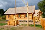
The artist Agris Liepiņš was the initiator of the project to recreate a 12th-century Ancient Latvian wooden castle. The building was erected in 1997 on the basis of samples from the remnants of castles found at various castle hills in Latvia. This is an idealised version of the residence of Uldevens, who was once the senior official of the Lielvārde region.
|
|
 |
The Dole is the largest island in the Daugava River, surrounded to the Northeast by the rapid waters of the Daugava and to the Southwest by calm and gradually overgrown waters from Dry Daugava. The island is a specially protected nature park, established in 1986 to protect the landscape and cultural and historical values of the island in the wake of the construction of the Rīga hydroelectric power plant, as well as rare and protected species of plants and animals. The island is also meant to provide education and leisure for visitors. Best known on the island is the Daugava Museum, which is in the mansion of the old Dole Estate. The museum features some 13,000 exhibits that speak to the history of the island and the river – Baltic and Livonian apparel, tools and household objects. The exhibition also presents the Daugava as an important waterway and the related history of forms of transport and rafters. In the park is an open-air exhibition with reconstructed lamprey eel traps and a barrier to fish salmon, along with a set of fishing tools. A dolomite cliff is alongside the museum on the steep shore of the Dry Daugava. The ruins of the Vecdole castle can be found on the south-eastern end of the island, near Bēči. |
|
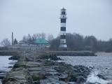 |
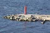
The Western breakwater was finished in 1885 and stretches 860 metres into the sea. Together with the Eastern breakwater it regulates the flow of water from the Daugava River into the sea, also reducing silt levels in the river. The structure of the breakwater is based on piles that are strengthened with rocks. The breakwater has been reconstructed and strengthened several times. During the 19th century, it held a prison for offenders. Approximately ½ of the breakwater has been restored with cement, but the rest of it is in fairly sad shape. Polish King Stefan Báthory ordered the construction of a lighthouse alongside the Daugava in 1528, and the first map to show a lighthouse was produced in 1536. A 1721 list of lighthouses in the Russian Empire notes a pile of rocks at the location upon which a fire was lit. Later there were wooden and stone towers that were destroyed during wars. The current Daugavgrīva lighthouse was built in 1957 and is 35 m high. Its light can be seen at a distance of 18 nautical miles. |
|
 |
Before its flooding, the canyon of the Daugava River between Pļaviņas and Koknese was one of the most outstanding and beautiful parts of the Baltic terrain, and Oliņkalns hill was one of the largest castle hills in Latvia. The Andrejs cliff as up to 20 metres high, and it was part of the Daugava canyon. Before the area was flooded because of the construction of the Pļaviņas hydroelectric power plant, there were rapids near the hill that made it hard for rafters to sail down the river. Today it is a small island in the reservoir of the plant (it can be seen from the side of the Rīga-Daugavpils highway (A6) opposite Stukmaņi). It is separated from the shore by 300 metres of river, under which the Dūņas valley is now resting. A small part of the ramparts of the castle hill can still be seen on the island along with the ruins of an open-air stage and a few metres of the dolomite cliff that have remained above water. It is thought that the Alene castle was on the hill in the 13th century. Latvian mountain climbers installed a memorial stone in 1998 opposite Oliņkalns hill. |
|
 |
The “Gulbji” Selonian homestead is one of the very few places in Latvia where you can see a farm typical of the historical region of Selonia with its typical buildings. “Gulbji” is comparatively far from major roads and populated areas. It is on the so-called Dronku Island, not far from the beginning of the ancient Dviete River valley. The owners of “Gulbji” have collected a wealth of ancient household objects. Visitors can study the farm, examine a collection of medicinal plants, enjoy Selonian foods, or take a “black sauna.” It could be said that people at “Gulbji” have a natural farm which nurtures and maintains the traditions of the historical region. Latvian cuisine: Crepes, grit soup, cream of potato soup, beans sautéed in a special sauce, fruit dessert, bread soup with whipped cream, tortes, herbal teas. Special foods: Zeppelins. |
|
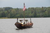 |
To view the Daugava River from a different perspective, visit the Liepkalni bakery, which offers tours in a Viking longboat that is called “Lāčplēsis” and can carry up to 24 people. The Daugava has always been an important transport corridor for many species and animals that arrived in Latvia because of that, as well as for people and tribes that lived along the banks of the Daugava River and the shores of the Baltic Sea. |


