


Kontaktinformation
Related objects
| Foto | Name | Beschreibung |
|---|---|---|
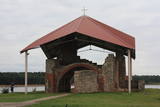 |
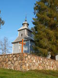
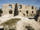
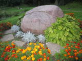
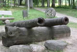
Seit den 70er Jahren des 20.Jh. befindet sich diese auf der kleinen Insel des hl. Meinhards im Staubecken des Rigaer Wasserkraftwerkes. Die hier zu sehenden Baureste sind die Ruine des ältesten Steinbaus Lettlands. Der Bau der Kirche wurde 1184 begonnen, sie wurde mehrfach umgebaut und zerstört, zuletzt 1916. Heute ist die Ruine des Gotteshauses konserviert, es befindet sich eine Metallüberdachung darüber, die Ufer der Insel sind befestigt. Auf der Insel ist ein 10m hohes Kreuz errichtet (Künstler E. Samovičs) und ein Steinaltar (Bildhauer J, Karlobs) |
|
 |
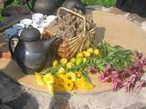
Zichorien– und Getreideverarbeitungsfabrik in Sēlija. Nereta 20 km, Viesīte 16 km, Aknīste 13 km. Der Kaffee wird nach den Rezepten von Oma Alida zubereitet. Gerösteter Zichorienkaffee PAULĪNE (Roggen, Zichorien, Karotten, Eicheln), gerösteter Roggen–, Zichorien– und Hanfkaffee SĒLIJA (Roggen, Zichorien, Karotten, Hanfblätter), Roggenmalz–, Zichorien– und Hopfenkaffee VIESĪTE (Roggenmalzkörner, Zichorien, Hopfen). Produkte können gekauft werden. |
|
 |
Gedenkzimmer von Janis Jaunsudrabins in Kaplava *Object Inactive*

|
Zwei Jahre hat der Schriftsteller in Kaplava gewohnt und gearbeitet. Das Erlebnis dieser Zeit spiegelte sich in einem von ihm geschriebenen Roman „Augšzemnieki” (“Oberländer”) wider. In Kaplava ist ein Gedenkzimmer des Schriftstellers eingerichtet, neben dem Gebäude befindet sich ein Gedenkstein. |
 |
This is the oldest arboretum in Latvia. It was planned by the owner of the Skrīveri Estate, Maximmilian von Sievers (1857-1919). It has to be said that before World War I, there were two times more species of plants in the park than is the case now. The plants are grouped in accordance with the geo-botanic regions of the world. There are trails in the park, and signs showing the Latvian and Latin name of each plant are there, as well. There’s a fountain which is operated from every hour on the hour from 11:00 AM until 11:00 PM from Tuesday until Sunday. On the other side of the Rīga-Daugavpils highway is the Skrīveri Forest Park with hiking trails.
|
|
 |
Das Café befindet sich am Ufer des Flusses Daugava zwischen Stukmani und Plavinas und es ist mit einer Bäckerei und einem Geschäft verbunden. Mehrere dutzende Brotsorten, Gebäck, Torten, Kuchen und Brötchen. Lettische Küche: Suppe mit Fleischbällchen, Ampfersuppe, Bauernfrühstück, Spiegeleier, Schweinerippen, graue Erbsen, Kartoffelpfannkuchen mit Lachs, dünne Pfannkuchen, Brombeercreme. Das besondere Gericht: Roggenbrot von Liepkalni, Brotkwass. |
|
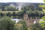 |
Found on the right bank of the Daugava where the little Karikste river flows into the Daugava, all that remains of the castle today is a set of ruined walls and foundations. The castle was built by the Livonian Order in 1224, and it was inhabited until the mid-17th century, when it was sacked during the Polish-Swedish war. The ruins offer a good view of the local gravel road that goes along the right bank of the river valley.
|
|
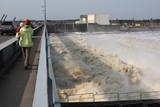 |
Das größte Wasserkraftwerk Lettlands, der erste Bauabschnitt begann 1936 am rechten Daugavaufer (Architekt E. Laube). Das erste Maschinenhaus (mit einer Leistung von 17 MW das größte im gesamten Baltikum) wurde 1936 in Betrieb genommen. Von 1976 – 1979 fand der zweite Bauabschnitt des Kraftwerkes statt, dabei wurde ein neues Gebäude am linken Daugava-Ufer errichtet, drei neue Turbinen mit Generatoren aufgestellt und somit die Leistung des Kraftwerkes auf 260 MW gesteigert. Weitere Rekonstruktionen am Kraftwerk fanden von 1998 – 2001 am linken Daugava-Ufer statt, wo sich jetzt auch das Energetik- Museum befindet. |
|
 |
The central part of the town of Krāslava is an historical monument because its low-story and beautiful wooden buildings. The best views of the historical centre relate to the carp park near the Adamova trail, the Karņicskis hill, the bridge across the Daugava (Prospekta Street), and the Priedaine viewing tower on the left bank of the Daugava River. |
|
 |
Krustpils wurde das erste Mal 1237 in Zusammenhang mit einem Bau der Kreuzburg am rechten Daugava-Ufer historisch erwähnt. 1511 wurde Krustpils als eine Ortschaft erwähnt. 1585 hat der König von Polen Stephan Báthory die Ortschaft Krustpils dem Nikolaus von Korff geschickt und gehörte Krustpils den Baronen von Korff bis 1920. 1626 geschahen nahe Krustpils die Schlachten zwischen schwedischen und polnischen Truppen. Die ruinierte Ortschaft hatte keine Entwicklung bis zum 19. Jahrhundert. Seinerseits wurde Jēkabpils in der Mitte des 17. Jahrhunderts als eine Siedlung der verfolgten Altgläubigen aus Russland – Sloboda gegründet. Auf dem Fluss Daugava befinden sich gegenüber Krustpils un Jēkabpils die Flussschnellen, deswegen mussten die Flößer anhalten und die Waren auf die Fuhren verladen. Demzufolge blühte die Siedlung auf und 1670 verlieh die die Stadtrechte und den Namen Jēkabpils zu Ehren des Herzogs von Kurland. 1861 begann das Aufblühen von Krustpils nach der Eröffnung der Eisenbahnstrecke Rīga – Daugavpils und endete sich von Jēkabpils. 1962 wurden Krustpils und Jēkabpils zu einer Verwaltungseinheit mit dem Namen Jēkabpils. Bis heutzutage sind in Jēkabpils eine für das 19. Jahrhundert typische einstöckige Holzbebauung, die um die Wende des 19. und 20. Jahrhunderts errichteten Gebäude aus rotem Stein, Kirchen von sieben verschiedenen Konfessionen erhalten geblieben. Einer das linke Daugava-Ufer umschließende Schutzdamm (Anfang des Baues 1861) wurde mit dem Ziel gebaut, die Stadt von Überflutungen zu schützen. Heutzutage ist der Damm zu einer Promenade umgebaut, die ein beliebter Platz der Bewohner für Spaziergänge und Erholung ist. |
|
 |
Befindet sich im Park von Lielvārde, in der Anfang des 19.Jh. erbauten Scheune des Herrenhauses Lielvārde, die später auch als Wohngebäude genutzt worden war. 1922 war eine Veranda angebaut worden. Das Museum befindet sich in diesem Gebäude seit 1970 und in dessen Sammlung gibt es Materialien über das lettische Volksepos “Lāčplēsis“(der Bärenzerreißer) und dessen Autor Andrejs Pumpurs (1841-1902), sowie über die Geschichte und die Ethnografie des Kreises Lielvārde. Neben dem Museum liegt ein großer Stein – das Bett des Lāčplēsis (etwa 80t) und ein Bruchstück, das „die Decke des Lāčplēsis“ genannt wird. Beide Steine befanden sich einst in der Daugava, neben der Insel von Lielvārde, über die heute die Wasser des Kraftwerkes fließen. Direkt daneben kann man den Holzklotz der Spīdala sehen, der von Aizkraukle hierher gebracht worden war. |
|
 |
Das Café befindet sich 0,2 km von dem Bahnhof von Skriveri entfernt. Dieses Familienunternehmen (seit 2006) stellt hausgemachtes Eis aus selbstgezüchteten Früchten und Beeren (Sahneeis Plombirs, Sahneeis und Eis aus Jogurt) und Sorbets, sowie Eis mit modernem Geschmack (Sprottengeschmack, Geschmack des blauen Käses und Kartoffeleis mit Tomatensoße) her. Man kann den Prozess der Eisherstellung auch verfolgen. Das besondere Gericht: Meerretticheis mit Hering. |
|
 |
Eine aus Holz von den einheimischen Handwerkern nach der Finanzierung der Grafen Plater gebaute Kirche stammte von 1655 bis 1658 als eine nicht große einschiffige Basilika. Das einzigartige kulturhistorische Denkmal gilt als eine der ältesten Holzkirchen in Lettgallen. Die Schnitzerei des Zentralaltars in den Formen des Barocks wurde von den Meistern der Schnitzereischule von Stelmuže erschaffen. Im Seitenaltar befindet sich das Bild aus dem 18. Jahrhundert “St. Maria Magdalena”. Die Kirche wurde 1698 auf den jetzigen Platz – am rechten Daugava-Ufer befördert. Das Gebäude wurde mehrmals – 1890 und 1918 erneuert. Um die Kirche herum befindet sich einen Steinzaun aus dem Ende des 17. Jahrhunderts mit einem separat stehenden Glockenturm aus der Mitte des 19. Jahrhunderts, der 2002 restauriert wurde. Gemäß verschiedenen Informationsquellen kann man behaupten, dass die Gemeinde von Indrica die älteste in Lettgallen ist. |
|
 |
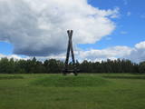
Nach dem Bau des Stausees des Rigaer Wasserkraftwerkes ist es eine Insel, vor dem Bau – eine Halbinsel am linken Ufer der Daugava. Während des Ersten Weltkriegs fanden auf der Todes Insel dauerhafte Kämpfe der Lettischen Schützen gegen die zahlenmäßig überlegenen deutschen Truppen statt. Am 25. Dezember 1916 haben die deutschen Truppen Giftgase gegen der Lettischen Schützen eingesetzt. Zum Andenken an diese Ereignisse wurde 1924 nach dem Projekt des Architekten E. Laube am nördlichen Ufer des Todes Insel ein Denkmal für die gefallenen Lettischen Schützen errichtet. Diese Insel ist per Boot erreichbar. Es ist wert, Schützengräben und Begräbnisse der Insel zu besichtigen. Am nordwestlichen Ufer der Insel befindet sich eine Bootsanlegestelle, aber unweit von der – ein Erholungsplatz. Vor kurzer Zeit wurde ein Fragment der Schützengräber mit den Erdhütten erneuert. Die Kämpfe auf der Todes Insel hat der lettische Schriftsteller Aleksandrs Grīns in seinem berühmten Werk „Seelen im Schneesturm” beschrieben. |
|
 |
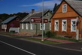
Eine alte, von den Letgallen bewohnte Ortschaft. Im 10. Jh. gelang der Kreis von Krāslava in den Händen der Fürsten von Polock, aber im 13. Jh. – in den Händen des Livländischen Ordens. Bis zum Anfang des 18. Jhs. bestand Krāslava als das Zentrum des Landgutes. Im Jahr 1729 hat Johann Ludwig Plater Krāslava für 1400 Taler gekauft. Die Familie Plater hat in Krāslava zwei Jahrhunderte geherrscht. In der Mitte des 18. Jhs. hat die Familie mit dem Bau des Schlosses begonnen. Nach der ersten Polnischen Teilung im Jahr 1772 wurde die Region Latgale an Russland angeschlossen. Krāslava begann zu verkümmern. Nach dem Bau der Eisenbahn Riga – Daugavpils – Witebsk (1865) blühte das wirtschaftliche Leben der Stadt wieder auf. Krāslava wurde wenig von den Ereignissen des Zweiten Weltkriegs betroffen, darum hat sich die Holzbebauung der Stadt aus dem Anfang des 20. Jhs. fast unberührt erhalten. |
|
 |
Zurzeit – eine Insel auf dem Stausee des Rigaer Wasserkraftwerkes, die per Boot erreichbar ist. Eine alte Wallburg von Sellen, die mehrmals während der 6 – 12 Jahrhunderte besiedelt wurde. Hier befand sich ein politisch-militärisches Zentrum der Region Sēlija. 1373 hat hier der Livländische Orden sowie auf den anderen alten Wallburgen eine Steinburg gebaut, die 1704 im Großen Nordischen Krieg vernichtet wurde. Bis heutzutage sind die Reste von einem viereckigen Turm, einen Raum für Wache und einen 12 m hohen Wall vor der Burg erhalten geblieben. Ungefähr 0,3 km nördlich von der Wallburg von Sēlpils ist die unter Wasser gesetzte Wallburg Oliņkalns zu sehen. |
|
 |
Die Geschichte von Koknese ist mit dem Bau der gemauerten Burg des Bischofs im Jahr 1209 an dem Zusammenfluss der Flüsse Daugava und Pērse verbunden. Die Burg von Koknese war ein bedeutender Kontrollpunkt auf dem Wasserweg Daugava, der nicht besetzt bis zum Jahr 1701 bestand, als die Burg von dem sächsischen Heer gesprengt wurde. Bis zur Bildung des Stausees des Wasserkraftwerks von Pļaviņas befand sich an diesem Ort der Felsen von Daugava, der einer der landschaftlich schönsten und von den Touristen am meisten besuchten Orte in Lettland war. Nördlich von den Burgruinen befindet sich der im Jahr 1900 eingerichtete Park von Koknese mit mittelalterlichen Friedhofsdenkmälern und schwedischen Kanonen aus dem 17. Jh. Die Reisenden können hier die Burg besichtigen, eine Bootsfahrt unternehmen, sowie mittelalterliches Geld prägen. |
|
 |
This venue organises seminars, courses and activities related to Latvian holidays and family celebrations. There are master’s classes about culinary heritage in
|
|
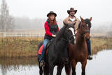 |
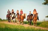
Die Wirtschaft züchtet lettische, weißrussische und litauische Pferdearten. Es werden Ausflüge mit Pferden und die Ausbildung von Anfängern angeboten. Entspannungsübungen auf dem Pferd und ein seltenes Angebot – Reittherapie oder eine besondere Entspannung für Kinder und Erwachsene sind im Angebot. Im Winter können sie Schlittenausflüge machen mit anschließendem Lagerfeuer mit Braten vom Fleisch und Glühwein. Übernachtung. Lettische Küche: Pilzschnitzel, Kartoffelklöße mit getrockneten Pilzen oder Fleisch, mit Sauerrahmsoße und Zwiebeln, gebratene Pfifferlinge mit neuen Kartoffeln, geschmorte Gemüse und Pilze, Erdbeeren mit Eis, das lettgallische Hausbranntwein Šmakovka. Das besondere Gericht: Himmelsbrei von Klajumi. |
|
 |
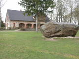
The rock is along the main street of Krāslava and is found at Augusta Street 12. After major reconstruction of the city’s infrastructure, the rock was successfully integrated into the surrounding landscape. The rock is 2.8 m long, 2.2 m wide and 700 cm high. It once served as a border stone for the village of Krāslava. It was placed there in 1729 to commemorate the day when the noble Plater dynasty bought Krāslava. The dynasty’s seal is engraved in the side of the rock along with the date when it was installed. Legend has it that Polish King Augustus II dined at the rock after a hunt, and that is why it is known as Augustus’ Rock. |
|
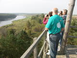 |
The old wooden tower at this site was torn down and replaced with the one that is there now. The restored tower offers one of the loveliest views in Eastern Latvia – one of the eight curves of the Daugava. This is the Rozališki curve. Here you will get a whole new sense of the Daugava River and its mighty valley in a place where the waters of a hydroelectric plant bubble away in our present day and age. It is claimed that the scene that is seen on the 10 lats note is based on the view which can be seen to the West from the tower. |
|
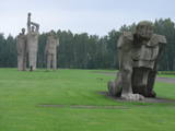 |
Sie befindet sich an der Stelle, an der sich im zweiten Weltkrieg ein Konzentrationslager der deutschen Nationalsozialisten befand. Es gibt Informationen, dass dort mehr als 50 000 Bürger besetzter europäischer Länder ums Leben kamen. Die Gedenkstätte für die Opfer totalitäer Regime ist eine der größten Europas (25 ha) und wurde 1967 eröffnet. Das Ensemble besteht aus großen Skulpturen und Skulpturgruppen – „Mutter“ , „Solidarität“, „Der Ungebrochene“ u.a., die vom „Weg des Leidens“ umschlossen werden. Im Torbereich ist eine thematische Ausstellung zu sehen. |
|
 |
Die archäologischen Ausgrabungen zeugen davon, dass die Ufer des Flusses Ogre von Liven bewohnt waren. Zu einer größeren Ortschaft und zu einem bedeutenden Kurort entwickelte sich Ogre nach dem Ausbau der Eisenbahn Rīga-Daugavpils im Jahr 1861. Bis zum Ersten Weltkrieg haben in der Stadt Ogre ihre Dienstleistungen ungefähr 300 Sommerhäuser angeboten, die während des Krieges hauptsächlich zerstört wurden. Das nächste ‘große‘ Ereignis geschah im Jahr 1965, als in Ogre eine der in Europa größten Wirkwarenfabriken gebaut wurde, wo Gastarbeiter aus Vietnam und anderen Ländern arbeiteten. Heute hat die Stadt ihren Ruf als ein Kurort nicht wiedererlangt, aber sie ist zu einem ziemlich exklusiven Ort für den Bau von Privathäusern geworden. |
|
 |
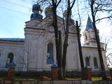
Der höchste Punkt im Südteil von Daugavpils – in der Umgebung der 18. Novembra Straße, wo auf einem relativ kleinen Territorium, im Umkreise von ~ 0,3 km sich die Kirchen von vier Konfessionen befinden: das Bethaus für Altgläubige in Daugavpils (1908 – 1928), die St. Boris und Gleb russisch-orthodoxe Kathedrale (1905), die römisch-katholische Kirche der Heiligsten Gottesmutter (1905) und die evangelisch-lutherische Kirche Martin Luthers (1893). |
|
 |
Befindet sich südlich der Stadt Koknese auf einer Insel mit einem Verbindungsweg zum Ufer, die von den Stauwässern des Wasserkraftwerkes Pļaviņas umgeben ist. Das fundamentale Objekt unter freiem Himmel wurde zum Gedenken an all jene Bewohner Lettlands errichtet, die unter den totalitären Regimen gelitten haben. Die ersten Arbeiten erfolgten hier 2008. Der Autor dieses Garten-Landschaft Projektes ist der japanische Landschaftsarchitekt Shunmyo Masuno. Obwohl der Garten noch nicht fertig gestellt ist, wurde er schnell zu einem beliebten Touristik-Objekt. Das erste eigenständige Bauwerk, das hier errichtet wurde, ist die Aussichtsterasse mit Blick auf die Burgruine Koknese und die lutherische Kirche. Durch dieses offene Konzept kann man bei jedem wiederholten Besuch hier etwas Neues entdecken. So entsteht hier ein wichtiger historischer Gedenkort des lettischen Volkes, an dem sich auch Besucher beteiligen dürfen, wenn sie einen Stein mitbringen und ihn dort niederlegen. |
|
 |
Eingerichtet im elterlichen Haus „Skudrās” des lettischen Komponisten und Dirigenten Pēteris Barisons (1904 – 1947). Man kann Gegenstände aus dem Besitz des Komponisten, Musikinstrumente, Dokumente u. a. anschauen. Führungen nach vorherigen Anmeldung. |
|
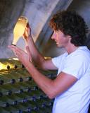 |
WEINGUT LIBERTU *Object Inactive*

|
Dieser Betrieb ist der einzige Ort in Lettland, wo die Besucher während der Führung mit der Gewinnung und Verwendung von Birken- und Ahornsäften bekanntgemacht werden. Aus Birkensaft werden hier verschiedene Produkte erzeugt: Sirup, Wein, Brause und der starke Birkensaft (Schnaps). Hier kann man die erzeugten Produkte, frischen oder gefrorenen Birkensaft, sowie einen umweltfreundlichen Satz für die Gewinnung von Birkensaft kaufen. |
|
|
Befindet sich in Skrīveri, Daugavas Straße 58. Das erste Haus des Schriftstellers (1877 – 1970) wurde 1908 gebaut, aber jetziges Haus – im Jahre 1921 auf der Grundlage des ersten Hauses. Im Gebäude ist ein Museum eingerichtet. Die Exposition des Museum veranschaulicht einen Lebens- und Schaffensweg des Schriftstellers, sowie wie der Roman “Grüne Erde” erschaffen wurde. Neben dem Haus ist ein Garten.1952 hat der Schriftsteller das Haus mit dem Garten der Staat geschenkt. Es werden Führungen und museumspädagogische Programme angeboten. |
|
 |
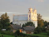
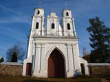
Befindet sich am höchsten mit Bäumen bewachsenen Ufer des Flusses Marki hinter der Grenzkontrollstelle von Piedruja. Zur Kirche führt eine Straße aus Pflastersteinen, die wahrscheinlich die einheimischen Bauer am Anfang des 20. Jahrhunderts gelegt haben. Es war eine Pflicht, ein Stein mitzunehmen, wenn man zum Gottesdienst geht. Dieser Stein wurde später für den Straßenbelag verwendet. Diese Kirche mit sechs Kuppeln ist eine der schönsten im heutigen Bezirk Krāslava. Die Kirche ist von 1883 bis 1885 an der Stelle der alten Holzkirche gemäß den architektonischen Formen der altrussischen Stadt Wladimir und bisantischen architektonischen Formen (17. Jahrhundert) gebaut worden. Es gibt Informationen, dass die Größe der Gemeinde ehemals sogar eine Tausend Gemeindemitglieder erreichte. |
|
 |
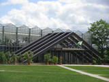
Ein zeitgemäßes und modernes Zentrum in einem historischen Scheunengebäude bildet einen einmaligen Komplex, in dem man eine Ausstellung über die Geschichte des Handwerks findet, das Glasmuseum, einen weiteren Ausstellungssaal, den längsten Gürtel der lettischen Volkstracht, einen Konferenzsaal, eine Wassergalerie. In den Werkstätten kann man Handwerkern der Umgebung, Töpfern, Texilherstellern, Glasbläsern bei der Arbeit zusehen und auch selbst mitwirken. |
|
 |
Das 1973 gegründete Museum befindet sich seit 1989 an der Stelle des Einzelhofes „Kalna Ziedi“. Das Gebäude, in dem sich die Dauerausstellung befindet, ist 1989 auf dem bestehenden Fundament des Wohnhauses gebaut, das Gebäude der Sammlung (1990) auf dem Fundament der Ställe. Der Raum für die wechselnden Ausstellungen (Jahr 2000) entstand an der Stelle der Scheune. Von dem ehemaligen Einzelhof ist somit also nur der Keller erhalten, die Anordnung der Gebäude entspricht jedoch der Planung eines Einzelhofes in Vidzeme (Livland). Die Sammlung des Museums ist der Geschichte der Umgebung seit der Steinzeit gewidmet. Unter freiem Himmel sind Bienenstöcke mit Kennzeichen der Besitzer zu sehen und auch in Lettland recht seltene Ringkreuze, die mittelalterliche Grabsteine waren. 100m nordöstlich des Museums ist der Kalna Ziedu - (Bergblüte -) Burghügel zu sehen, 200m südlich die Reste des Stammes einer Opfereiche (abgestorben 1994), am Ufer des Staubeckens des Wasserkraftwerkes von Pļaviņas. Von hier aus hat man einen weiten Ausblick über den Damm des Wasserkraftwerkes und auf die Stadt Pļavinas. |
|
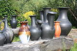 |
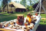
Der originelle Töpfer lädt zum Besuch ein, er bietet eine Führung an, zeigt seinen Arbeitsprozess, lässt die Besucher am Entstehungsprozess teilhaben und lädt auch Interessenten ein, beim Öffnen des Brennofens dabei zu sein. Man kann hier auch Töpferarbeiten erwerben. |
|
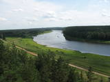 |
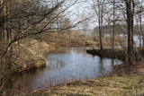
Dieser Park ist einer der reichsten und ungewöhnlichsten Naturparks in Lettland in Bezug auf seine natürlichen Ressourcen, die umgebende Natur, die Landschaften, die biologische Vielfalt des Gebiets und seiner Kulturdenkmäler, die man hier findet. Der größte Schatz ist das kaum veränderte Daugava-Flusstal mit seinen acht großen Windungen auf einer Länge von vier bis acht Kilometern. Dort sind ebenfalls die Schluchten der Nebenflüsse. Einen besonders schönen Blick kann man von den Steilufern des Daugava - Flusstales werfen, besonders bei den Slutiški- und Ververi - Klippen und dem Elerne - Hügel. Es gibt mehr als 20 archäologische Denkmäler an den Ufern des Tales, uralte Burgberge in Najene, Markova, Vecračina usw., unzählige Kirchen – wie die Kirchen Juzefova, Sprukti, Borovka, Elerne, Sīķele, Kaplava und andere, die Gutshöfe Rozališki, Lielborne und andere, das einzigartige Altgläubigendorf Slutiški. Es gibt interessante Naturpfade und Fahrradrouten in diesem Gebiet. Man kann auf Pferden ausreiten und es gibt einen Aussichtsturm mit weiteren Möglichkeiten für Touristen. Die Daugava hinunter zu paddeln ist eine interessante Möglichkeit, seine Zeit zu verbringen.
|
|
 |
Unweit von der Rigaer Ringstraße befindet sich auf dem rechten Ufer der Daugava ein vom Bildhauer Ģ. Burvis 1994 errichtetes Denkmal – Gedenkzeichen für Daugava-Liven und ihren Anführer Ako, der 1206 den Aufstand der Liven gegen Kreuzritter leitete. In der Umgebung vom Denkmal ist entlang des Daugava-Ufers ein breiter Platz für Erholung und Spaziergänge eingerichtet. Es ist einer der malerischsten Plätze an den Ufern des Daugava-Unterlaufes. Etwas weiter sind am Flussufer die Informationsstände zu finden, die die Geschichte der Daugava-Ufer vor dem Bau des Rigaer Wasserkraftwerkes darstellen. |
|
 |
Ein Haus 12 km von Krāslava entfernt. Wir bieten Ausritte, Wanderungen, Ausfahrten in einer Droschke oder in einem Schlitten an sowie Boots- und Floßfahrten in dem Naturpark "Daugavas loki" und in dem lettisch-belorussischen Grenzgebiet an. Im Angebot: Ferienhäuser, Küche der Region Latgale, Pferdestall, Trainer, ländliche Sauna. |
|
 |
The National Botanical Garden in Salaspils ranks as the largest botanical garden in Latvia and in the Baltics with a territory of 136 hectares. The National botanical garden collection consists of about 14 thousand different varieties. More than 5,000 plants are found in the arboretum, as well as various other exhibitions, such as orchards, rosaries, ornamental plants. Botanical Gardens can inspire you to uprade your own garden assortment with new plant varieties and offers the experience of learning about botanical knowledge in nature. In addition, it presents opportunity to expand your personal photo archive with an exclusive background photographs and close-ups. There is a playground for children, comfortable cycling paths, nordic walking paths, picnic possibilities. |
|
 |
Die größte Ortschaft im Südosten Lettlands, die vom Süden vom Fluss Daugava umgeströmt wird. Der Fluss ist gleichzeitig die Grenze zwischen Lettland und Weißrussland. Die Mitte des Flusses ist die Grenze zwischen zwei Ländern. Piedruja besteht aus zwei Teilen – Piedruja und Aleksandrova, die von der Zentralstraße (Straße V 631 ) getrennt sind. Piedruja hat sich als ein gegenüberliegendes Territorium der Stadt Druja entwickelt, die sich am linken Daugava-Ufer befindet. Zwei Teile gehörten im 17. Jahrhundert dem Hochadelgeschlecht Sapieha des Großfürstentums Litauens. Die Häuser mit wenig Stockwerken von Druja und eine zerstörte Kirche sind gut vom Piedruja-Ufer zu sehen. Es lohnt sich, Piedruja und die Umgebung, zu Fuß zu gehen, weil die Holzhäuser mit wenig Stockwerken stellenweise an die Häuser in den Freilichtmuseen erinnern. Piedruja sieht gepflegt aus, zwischen zwei Kirchen ist ein malerischer Garten angelegt. Mit bedeutenden Objekten – mit zwei Kirchen und Daugava-Stein macht der Piedruja-Pfad bekannt. Im Teil Aleksandrova befindet sich das Hotel „Piedruja”, das ein besonderes touristisches Produkt anbietet – eine Abendunterhaltung im lettgallischen, russischen und weißrussischen Stil. Vor der Reise nach Piedruja muss man die Aufenthaltserlaubnis fürs Grenzgebiet erhalten. Eine Grenzkontrollstelle befindet sich in Piedruja am Daugava-Ufer, wo noch relativ vor nicht langer Zeit eine der Überfahrten über den Fluss Daugava in Betrieb war. |
|
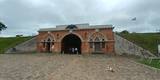 |
Die Festung ist einzige fast ohne Änderungen erhaltete Festung der ersten Hälfte des 19 Jahrhunderts in Lettland und sogar in baltischen Staaten. Die Festung wurde noch im Laufe der Bauarbeiten in der Zeit des Krieges im Jahr 1812, als auch wegen der Überschwemmung von Daugava im Jahr 1829 niedergerissen. Die Festung von Daugavpils hatte ein sehr gut entwickeltes Schützsystem und sie war strategisch sehr wichtiger Stützpunkt gegen die napoleonische Armee. Die Planung des Territoriums ist eiförmig und das Territorium wird in einzelnen Quartalen eingeteilt mit einem Paradenplatz im Zentrum. Im Jahr 1893. wurde in der Festung einen Kriegslager eingerichtet, diese wurde auch als Gefängnis genutzt. Vor dem 1.Weltkrieg dienten bei der Garnison von Daugavpils solche bekannte Militärpersonen wie der General J. Balodis, Oberst F. Briedis u.a. In der sowjetischen Zeit wurde in der Festung die sowjetische Armee untergebracht und hier befindete sich die oberste Schule für Kriegsfliegertechnicker. Heutzutage ist die Festung von Daugavpils einigermaßen ”eine Stadt in der Stad” mit der Einwohnergemeinde, die mit den beeindruckenden Mauern von der Außenwelt abgeschlossen sind. Auch dieses Objekt als ein einzigartiges historisches Denkmal sich in einem kritischen Zustand befindet. Wegen der schlechten Zustand es ist sicherer die Gebäude und Gänge nur von außen zu besichtigen!
|
|
 |
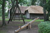
Hier kann man eine Dampflokomobile, eine Dreschmaschine und einen Bauernhof aus dem 19. Jh. besichtigen, der einem durchschnittlich wohlhabenden Bauer in der Region Sēlija gehörte und auf dem sich ein Wohnhaus mit einem Mantelschornstein, zwei Kornkammern, eine Getreidedarre, eine Sauna, eine Windmühle und eine Schmiede befinden. Touristengruppen werden hier thematische Veranstaltungen angeboten: Handwerksarbeiten auf dem Hof der Selen, Wenn der Honig auf der Zunge taut und Heirat auf dem Hof der Selen. |
|
 |
Das Dorf der Altgläubigen Slutiški (das einzige seiner Art in Lettland) befindet sich an einem sehr landschaftlich schönen Ort – in dem Naturpark der Bögen des Flusses Daugava. In dem Haus der Altgläubigen ist ein Museum eingerichtet, wo man eine Vorstellung von der Lebensart der Altgläubigen bekommen kann. Hier wird das thematische Programm Das Erbe der Altgläubigen der Region Latgale angeboten. |
|
 |
Nach Angaben befand sich die Kirche an dieser Stelle schon im 17. Jahrhundert. Die jetzige Kirche wurde von 1792 bis 1794 gebaut. Der Autor des Projektes eines kuppelförmigen Gebäudes war Christoph Haberland, der Hauptbaumeister von Riga. Eine Form der Kuppel sichert eine gute Akustik in den Innenräumen. Der Altar ist gegenüber der Eingangstür eingerichtet. Zwischen den Kolonnen des Gebäudes befindet sich ein Altarbild, das Christus und St. Peter in aufgewühltem Meer darstellt. Zu den bedeutenden Gegenständen der Innenausstattung gehören Weinbecher, Kerzenträger aus den 18 – 19 Jahrhunderten u.a. 2014 wurde das Gebäude restauriert. Südlich von der Kirche befindet sich der Friedhof von Katlakalns, auf dem ein berühmter deutsch-baltischer Publizist und Schriftsteller Garlieb Merkel (1769 – 1850) bestattet wurde, der eine große Rolle in der Aufhebung der Leibeigenschaft im Baltikum spielte. |
|
 |
Für Reduzierung der Verschlammung der Flussmündung und Regelung des Flusslaufes wurde im Mitte des 19. Jahrhunderts die Ostmole in der Länge von 980 Meter gebaut. Eine Holzpfahlbauweise bildet die Gründung der Mole, die mit Steinen bedeckt ist. Die 2,2 km lange Mole ist heutzutage rekonstruiert und dient als beliebter Platz für Spaziergänge, Erholung und Angeln in allen Jahreszeiten. Von der Mole kann man Vögel beobachten, von Zeit zu Zeit kann man Glück haben und eine Robbe beobachten. Am Anfang der Mole sind zwei Gedenksteine mit Inschrift zu sehen. Die Inschrift lautet, dass den Bau der Mole der Kaiser Alexander II. von Russland (1856) und seinen Thronfolger Nikolaus Alexandrowitsch (1860) besucht haben. Dieses Ereignis erhöht die Bedeutung des Rigaer Hafens im Kontext der damaligen Ostseehandelswege. |
|
 |
This 368 metre structure is the highest television tower in the European Union. Its viewing area, which is at a height of 97 metres, is the highest publicly available viewing area in Latvia. The location offers a fantastic view of Rīga and Old Rīga to Pārdaugava, the Bay of Rīga and Sigulda – a radius of at least 50 kilometres.
|
|
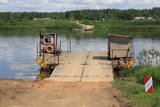 |
This is one of two crossing points across the Daugava (the other is near Līvāni). It is an exotic form of transportation to carry pedestrians, bicyclists and light automobiles across the river. There is a motor that operates a 200-metre metal cable. The crossing point is based on Soviet military pontoons that were used to build pontoon bridges for tanks. The crossing point was established by its owners. The Dunava Catholic Church is on the left bank of the river, and nearby is a monument to rafters. During the 1820s, there were three crossing points of this type across the Daugava. |
|
 |
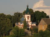
Befindet sich am rechten Daugava-Ufer. Von verschiedenen Orten in Pedruja sind schöne Blicke auf diese Kirche. Die erste Holzkirche ist in Piedruja nach dem Befehl des Fürsten Jan Sapieha 1632 gebaut worden. 1759 ist die Kirche verbrannt worden. Die bis heute erhaltene Steinkirche im Barockstil mit zwei Türmen (wahrscheinlich, der Projektautor – ein italienischer Architekt A. Paroko) ist 1759 gebaut worden. Unter dem 27 m hohen (Höhe der Türme) Gebäude befinden sich Kellerräume. In den Türmen befinden sich drei Glocken (der größte stammt aus dem Jahr 1711, der mittlere – aus dem Jahr 1897, der kleinste – aus dem Jahr 1619). Die größte Glocke wiegt fast 0,4 Tonnen. In den Innenräumen der Kirche sind viele bedeutende kulturhistorische Gegenstände zu sehen – der Zentralaltar aus Holz mit dem Bild Maria Himmelfahrt, drei Altäre aus dem 18. Jahrhundert, die Kanzel aus dem Anfang des 19. Jahrhunderts, der St. Anton Altar, die Freske mit der Abbildung der Heiligen Dreifaltigkeit, das Kirchengerät aus dem 17. Jahrhundert u.a. Neben dem Gebäude befindet sich ein großer Garten mit einem Steinzaun und Steinbegräbniskapellen. Im Garten befinden sich die Gräber der Pfarrer Kazimirs Konvalevskis un Broņeslavs Stefanovičs. Der Pfarrer Broņeslavs Stefanovičs hatte eine große Rolle im Wiederaufbau der Kirche nach dem Ersten Weltkrieg. Die Gemeinde von Piedruja fing an, sich in der ersten Hälfte des 17. Jahrhunderts zu bilden. |
|
 |
Befindet sich in Pļaviņas, gegenüber der Kaļķu Straße am Daugava-Ufer, wo aus den Balkenhölzern und Steinen ein symbolischer Teil eines Floßes errichtet wurde. In der Umgebung befinden sich die Informationsstände mit Bildern, die über alltägliche harte Arbeit der Flößer bei der Überwindung von Flussschnellen erzählen. |
|
 |
Das erste Unternehmen, das 1957 die Produktion der beliebten Milch-Bonbons „Gotiņa“aufnahm. Hier kann man köstliche Bonbons erwerben und auch an einer Führung teilnehmen, der Inhaber des Unternehmens ist zugleich der Haupt- Bonbonmeister. |
|
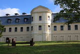 |
Bis heute sind mehrere Gebäude des Gutshofes erhalten, der zur Zeit der Grafen Plater erbaut worden war. Das alte Schloss, das sich am Rand der heutigen Grāfu Plāteru iela – am Ufer des Jāņupīte (Johannis –Flüsschens) befindet, ist 1759 im Barockstil erbaut. Der Architekt war der Venezianer Antonio Paraco. Später wurde es umgebaut, und nach dem Bau des Neuen Schlosses befand sich im untersten Stockwerk die Sommerresidenz der Familie der Plater, im zweiten und dritten Stockwerk war eine Bibliothek mit etwa 20 000 Einheiten. Diese wurde im zweiten Weltkrieg vernichtet, nachdem man einen Großteil des Bestandes in andere Residenzen der Grafen überführt hatte. Der Bau des neuen Schlosses des Gutshofes Krāslava (am oberen Uferabschnitt des Daugavatals) wurde 1765 begonnen (Architekt Domenico Paraco), anfänglich im Barock, aber um die Jahrhundertwende vom 18. zum 19. Jh. Wurde es im klassizistischen Stil umgebaut. Im Schloss entdeckte man einzigartige Rokoko-Wandgemälde mit Ansichten von Rom, die nach Vorlagen aus polnischen Schlössern in den 60er und 70er Jahren des 18. Jh. entstanden waren. Im Neuen Schloss war bis in die 70er Jahre des 20 Jh. eine Mittelschlule untergebracht. Das verlassene Schloss verwandelte sich bis vor kurzem noch allmählich in eine Ruine. Nun wurden umfangreiche Renovierungsarbeiten an der Fassade vorgenommen, und diese bietet nun einen gepflegten Anblick. Um das Schloss herum befindet sich ein im 18. Jh. geschaffener romantischer Landschaftspark – der Park der Grafen Plater (Grāfu Plāteru parks), der im Daugava Tal und diese kreuzenden Hängen angelegt worden war. Hier ist eine künstliche Grotte wieder hergestellt worden, und der Löwe – der Wächter des Schlosses, sowie eine Treppe an ihrer ursprünglichen Stelle, Parkwege und der Hof. |
|
 |
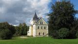
Das beindruckende Denkmal des lettgalischen Barocks. Gebaut in der Periode von 1755 bis 1767 nach dem Projekt des italienischen Architekten A. Parako. Eine Kapelle mit der Reliquie vom St. Donatus, dem Beschützer von Krāslava. |
|
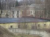 |
In den 40er Jahren des 17.Jh. erbaute die schwedische Armee hier eine moderne Festung mit fünf Bastionen und zwei Toren. Hier befanden sich 120 Kanonen und Mörser, Soldaten-Kasernen, Offizierswohnungen, eine Garnisonskirche, Lebensmittel – und Munitionslager. Als Folge des Großen Nordischen Krieges fiel die Festung 1710 in die Hände der russischen Armee. Auch nach der Besetzung Lettlands 1940 stationierte die Sowjetunion hier Einheiten ihrer Marine. Von außen sind Mauern, Bastionen, der Festungsgraben und ein kleiner Teil der alten Kirche zu sehen. Neben der Festung befindet sich ein ehemaliges sowjetisches Militärgelände mit verlassenen Gebäuden und einem Denkmal für Soldaten, die auf U-Booten ihren Dienst geleistet haben. Die Festung ist samstags und sonntags für Besucher geöffnet. |
|
 |
In der Stadt Pļaviņas neben der Einmündung des Flusses Skanstupīte in Daugava (Park der Freundschaft) befindet sich Überreste der nicht großen und niedrigen Schützwälle und Bastionen von Anfang des 17. Jahrhunderts – sogenannten Schwedischen Schützgräben. Da sich im 17 Jahrhunder an diesem Ort die Grenzen von Vidzeme (schwedische Verwaltung), Latgale (polische Verwaltung) und Herzogtum von Kurland (am gegenüberliegenden Ufer von Daugava) kreuzten, war hier ein militärisch strategischer und politisch bedeutender Ort. Im Jahr 1625 haben die Polen hier eine Niederlage für die Schweden beigebracht und der schwedische König Gustav Adolf ist fast ums Leben gekommen. Es gibt auch noch anderswo in Lettland solche mittelalterische Militärobjekte - Schutzgräben erhalten geblieben.
|
|
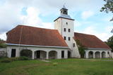 |
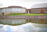
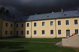
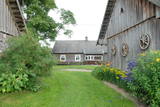
The complex dates back to the 17th and 18th century, when a fortress was replaced by a mansion and other buildings. The rectangular yard that is in the centre of the state is surrounded by the mansion, two granaries with columns that were built opposite one another, a stable and a wheelhouse. The stable and wheelhouse, the bell tower and the gate create the most impressive part of the buildings. Bells were rung because of religious rituals, but also to inform people at the estate about everyday issues. The silhouette of the building is reminiscent of cloisters, city halls and churches that were common in Europe in the 18th century. In 1780, the estate was taken over by the family of Karl Otto von Löwenstern, and the mansion can only be viewed from the outside. There is a hiking trail near the estate. |
|
 |
Ein Platz eines alten und bedeutenden Handels- und Handwerkszentrum am linken Ufer des Stausees des Rigaer Wasserkraftwerkes, der sich über den Fluss auf 15 m erhöht. Man nimmt an, dass bei einem kleinen Bach – einer Mündung des Flusses Varžupīte nahe der Wallanlage von Daugava sich ein in den historischen Unterlagen erwähnter Hafen von Semgallen befand. Gemäß gefundenen alten Gegenständen kann man behaupten, dass die Wallburg und eine alte Stadt am Fuße der Wallburg bis zum Ende des 12. Jahrhunderts besiedelt waren, als die Bedeutung von Daugmale von der rasch wachsenden Stadt Riga verringert wurde. Der Fuße der Wallburg ist befestigt. |
|
 |
Befindet sich im südöstlichen Teil von Piedruja am Daugava -Ufer. Zum Stein führt den Piedruja-Pfad und einen örtlichen Landweg. Der Autor des Gedenksteins ist der Bildhauer Vilnis Titāns. Auf dem Stein ist das Wort Daugava in sieben Sprachen angebracht: auf Lettisch, Livisch, Estnisch, Polnisch, Russisch, Deutsch und Finnisch. Vom Stein ist sehr gut die weißrussische Stadt Druja am gegenüberliegenden Daugava-Ufer und eine große Insel zu sehen, die den Fluss in zwei Teile teilt. Vor der Reise nach Piedruja muss man die Aufenthaltserlaubnis fürs Grenzgebiet erhalten. |
|
 |
Der Pfad führt hinauf zum Gipfel des Burgbergs von Markova (Blick auf das Flusstal), überquert das steile Tal des Bachs Putānu und verläuft zurück zu einem Abhang am rechten Ufer der Daugava, von wo aus man eine herrliche Aussicht auf das altgläubige Dorf Slutiški und den Abhang im Hintergrund hat.
|
|
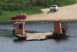 |
In the southern part of Līvāni, where Zemgales Street ends at the Daugava River, there is a fairly unusual and exotic form of transportation – one of three river crossings in Latvia. Unlike the one in Līgatne, this one is operated by a motor, not the flow of the river. It involves a cable across the river, and it is based on Soviet military pontoons that were used to build pontoon bridges for tanks. The crossing point was established by its owners. |
|
 |
Befindet sich am rechten Daugavaufer, etwa einen halben Kilometer oberhalb des Landwirtschaftlichen Instituts von Skrīveri. An dieser Stelle spaltet der tiefe Graben des Baches Ašķere das steile Ufer des Daugavatals. Der Burghügel war bereits im 1. Jahrtausend v. Chr. bewohnt, hier gab es Funde, die auf Lettgalen und Liven hinweisen. Im 13. Jh. erhob sich auf dem Hügel eine steinerne Burg, die im 17.Jh. zerstört wurde. Von deren Existenz ist heute nichts mehr zu sehen. Vom Burghügel, der auch als Krähenhügel (Kraukļu kalni) bezeichnet wird, bietet sich eine der schönsten Ansichten auf den Mittelteil der Daugava. Von hier aus (in Richtung Riga) lässt sich die Stelle einer alten Kirche erkennen (ein gepflegter Platz mit einem weissen Kreuz). Am Ufer des Ašķeres Baches entlang ist ein Wanderweg eingerichtet. Die gesamte Umgebung des Berghügels ist gepflegt, insgesamt sind vier Wanderwege eingerichtet, der längste davon ist der Daugava-Pfad (10km). |
|
 |
Established in 1900 at the place where the Pērse River flows into the Daugava (now the reservoir of the Pļaviņas hydroelectric power plant), the park offers a look at 17th century Swedish cannons and monuments from Medieval graves. Next to the high school in the park is a restored fountain, “Head of a Faun,” which was near the legendary Pērse waterfall during the 1930s. The waterfall is now underwater, but its location is indicated by a stone sculpture, “Girl of Pērse,” which was created by the sculptor Juris Zihmanis. A path leads to an 11 metre high wooden sculpture, “For Eternity,” by the sculptor Ģirts Burvis, and another sculpture, “Little Owl,” which is the work of the Rurāns brothers, both of whom are sculptors of wooden sculptures.
|
|
 |
Ein einzigartiges Objekt des Industrieerbes – die einzige für Besucher geöffnete Munitionsherstellungsfabrik in den Baltischen Ländern. Auf dem Territorium der Fabrik befindet sich der älteste noch produzierende Bleigießturm Europas. Die Gruppen von Touristen können nach vorherigen Anmeldung mit Guidebegleitung einen Betrieb, den Bleigießturm und das Museum besichtigen. Zurzeit produziert die Schrotkugelfabrik 9 Arten von Gewehrkugeln für Glattrohrwaffen sowie die Gewehrkugeln für Druckluftwaffen. Die Produktion wird in die Nachbarländer, nach Deutschland u.a. eingeführt. |
|
 |
Ein bedeutender Ort der lettischen Geschichte, denn hier befand sich im 12. und 13. Jh. das amtliche und auch kulturelle Zentrum des alten lettgalischen Landes Jersika mit der Burg des Herrschers Visvaldis am 18m hohen Ufer der Daugava, wo sich der mächtige Burghügel erhebt. |
|
 |
From the Asote castle hill, which is on the right bank of the Daugava River near Jēkabpils, there is a fine view of the Daugava River valley, the Ābeles Island, and the Kaupre castle hill that is at the northern end of the island.
|
|
 |
In diese konnte man über eine Zugbrücke gelangen, in dem man die äußere und die innere Vorburg durchquerte. Bis in die Mitte des 16. Jh. diente die Burg als Residenz des Komturs von Dünaburg. 1577 wurde sie vom Heer Iwans des Schrecklichen zerstört.Nach diesem Ereignis verlor Dünaburg seine strategische Bedeutung und der Bau eines Festungsbaus wurde dort begonnen, wo sich heute Daugavpils befindet. Neben der Ruine der Ordensburg befindet sich ein verkleinertes Modell der Burg, damit man sich vorstellen kann, wie es hier vor vielen Jahrhunderten ausgesehen hat. Vom Parkplatz bis zum Burghügel gelangt man über einen bequemen Pfad.Vom Burgberg hat man einen der schönsten Ausblicke auf den Naturpark der Daugavabiegungen. |
|
|
|
Das Dorf der Altgläubigen Slutiški (das einzige seiner Art in Lettland) befindet sich an einem sehr landschaftlich schönen Ort – in dem Naturpark der Bögen des Flusses Daugava. In dem Haus der Altgläubigen ist ein Museum eingerichtet, wo man eine Vorstellung von der Lebensart der Altgläubigen bekommen kann. Hier wird das thematische Programm Das Erbe der Altgläubigen der Region Latgale angeboten. |
|
 |
Ein von der Bildhauerin Solveiga Vasiļeva 2003 errichtetes Gedenkzeichen „Gottesohr” für Staburags befindet sich im Park von Vīgante am Platz, wo nach der Errichtung des Stausees des Wasserkraftwerkes von Pļaviņi eins der interessantesten geologischen Naturdenkmäler Lettlands unter Wasser gesetzt wurde. Staburags war ein von Sagen, Legenden und Erzählungen der Flößer umwobener 18,5 m hoher Kalksteinfelsen am linken Ufer des Daugava-Kanjons, das nach der letzten Eisperiode gebildet wurde. Aus dem Felsen floss die Quelle Liepavots, die auch unter Wasser gesetzt wurde. Der Felsen Staburags und das versunkene Daugava-Kanjon waren einige der populärsten touristischen Objekte Lettlands. |
|
|
|
Ein zeitgemäßes und modernes Zentrum in einem historischen Scheunengebäude bildet einen einmaligen Komplex, in dem man eine Ausstellung über die Geschichte des Handwerks findet, das Glasmuseum, einen weiteren Ausstellungssaal, den längsten Gürtel der lettischen Volkstracht, einen Konferenzsaal, eine Wassergalerie. In den Werkstätten kann man Handwerkern der Umgebung, Töpfern, Texilherstellern, Glasbläsern bei der Arbeit zusehen und auch selbst mitwirken. |
|
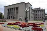 |
Found at Rīgas Street 22A, this impressive building was suggested by Latvian President Kārlis Ulmanis and built in 1936 and 1937 after a design by the architect Verners Vitands. It is seen as one of the most outstanding architectural monuments from the first period of Latvian independence, and it is said that it was once the most modern multifunctional building in all of Europe. The building now houses the Daugavpils Theatre, the Latgale Central Library, the Latvian Cultural Centre, the Latvian House, the US Information Centre, the Daugavpils Tourism Information Centre and other institutions. Unity Square is alongside the building, and beautiful compositions of flowers are nearby during the growing season. |
|
 |
Located in a cultural centre at Brīvības Street 15 in Ogre, the museum was established in 1980 and has a permanent exhibition, “Ogre – a Swimming and Air Spa, Relaxation and Everyday Life, 1920-1940,” which offers a good look at the “golden age” of Ogre, when it was a popular spa. Another exhibition, “Legendary Ogre” offers a different view. Visit the museum to find out what it is!
|
|
 |
Die Sammlung des Museums stellt die Daugava als bedeutenden historischen Wasserweg dar, hier sind auch Kleidungstücke und Gebrauchsgegenstände baltischer Stämme und der Liven zu sehen. |
|
 |
Das Schloss befindet sich in Krustpils, in der Rīgas Straße 216 b. Die Anfänge des Schlosses sind im Jahr 1237 zu suchen. Damals hat der Bischof von Riga Nikolai aus Magdeburg die Burg von Krustpils gebaut, die die erste befestigte Burg der Kreuzritter in der Region Latgale war. Vom Ende des 16. Jhs. bis zum Anfang des 20. Jhs. gehörte das Schloss dem Ritter Nikolai Korff (und seiner Familie). Das Schloss hat mehrmals unter Kriegen gelitten und ist umgebaut worden, aber trotzdem hat es bis heute seinen eingeschlossenen Hof erhalten, der den mittelalterlichen Burgen charakteristisch war. Mitte des 19. Jhs. bekommt das Schloss die heutige Innenausstattung des Historismus, aber es haben sich auch Elemente der älteren Bebauung erhalten: der Torturm, Hauptwände, Schießluken, Gewölbekonstruktionen, Fensternischen u.a. Während der Sowjetzeit befand sich in dem Schloss die Sowjetarmee, aber neben dem Schloss wurde die sogenannte Kriegsstadt eingerichtet, die heute Pils rajons (der Bezirk des Schlosses) genannt und der von der westlichen Seite von dem Teich Pils dīķis (Teich des Schlosses) eingeschlossen wird. Im Jahr 1994 wurde in dem Schloss das Geschichtsmuseum von Jēkabpils eingerichtet, das man unter der Leitung eines Reiseleiters oder individuell besichtigen kann. Zurzeit ist das Schloss eine der wenigen Sehenswürdigkeiten in Lettland, die man mit Hilfe eines Audio-Reiseführers kennenlernen kann. Von dem Schlossturm bietet sich eine schöne Aussicht. |
|
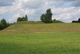 |
Eine von den relativ wenigen Wallburgen an den Daugava-Ufern, die nicht mit Bäumen und Gebüsch bewachsen sind, deswegen zeichnet sich eine klassische Form der Wallburg im Landschaftshintergrund ab. Die Wallburg von Dignāja wurde zu unterschiedlicher Zeit besiedelt, aber das Aufblühen im Zeitraum vom 5. bis zum 9. Jahrhundert erreichte, als sich hier ein bedeutendes Zentrum befand. Die Funde zeugen, dass die Wallburg von Dignāja von den lettgallischen Stämmen besiedelt wurde. Nach dem Einfall der Kreuzritter wurde auf der Wallburg eine Ordensburg gebaut, die bis heutzutage nicht erhalten ist. Es sind die Legenden, die über einen ehemaligen unterirdischen Gang unter der Burg erzählen. Von der Wallburg ist einen schönen Blick aufs Daugava-Stromtal. Auf der Wallburg sind die Schutzgräber aus der Zeit des Ersten Weltkriegs erhalten. Am Fuß der Wallburg befand sich einst eine Siedlung. |
|
 |
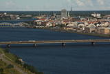
Ein Stadtbaudenkmal der 17 – 19 Jahrhunderte von staatlicher Bedeutung. In den Umgebungen der Straßen Jelgavas und Rātūža ist eine ehemalige Straßenplanung erhalten, die eine geschlossene Bebauung des Stadtviertels bildet. In Jaunjelgava befinden sich lutherische, katholische, orthodoxe und baptistische Kirchen. Eins der hervorragenden Architekturdenkmäler ist das 1912 in den Jugendstilformen gebaute Rathaus. Bis heutzutage ist keine der fünf Synagogen erhalten. Entlang des historischen Zentrums von Jaunjelgava ist am Daugava-Ufer eine Uferpromenade errichtet – ein beliebter Platz der Stadtbewohner für Spaziergänge, Erholung und Baden. |
|
 |
Der Heilpflanzenhof „Kurmīši“ befindet sich in der sauberen und landschaftlich reizvollen Gegend des Naturparks Schleifen der Daugava, und dem Landschaftsschutzgebiet Obere Daugava. Damit die natürlichen Standorte der Heilpflanzen erhalten bleiben, werden auf dem Hof „Kurmīši“ seit 1994 etwa 40 Heilpflanzen (Arten und Sorten) angebaut. Für Liebhaber von Arzneipflanzen und sonstigen Besuchern werden Führungen zum Thema Anbau und Verarbeitung von Heilpflanzen sowie zur Imkerei auf dem Hof angeboten. Anschließend kann man die Erzeugnisse des Hofs, Kräutertees, die mit Honig am schmackhaftesten sind, verkosten und kaufen. Eine besondere Atmosphäre entsteht durch die Kerzen aus echtem Bienenwachs. Auf dem Hof sind Picknickplätze vorbereitet und es werden Kerzen gegossen. Entsprechend kann man auch edle Souvenirs aus Bienenwachs kaufen. |
|
 |
This centre is a workshop for eleven potters, including some from the “Potters School.” The centre offers various activities, including master classes, demonstrations of pottery work, and exhibitions of finished products. You can commission products or buy new ones. |
|
 |
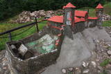
The artist Agris Liepiņš was the initiator of the project to recreate a 12th-century Ancient Latvian wooden castle. The building was erected in 1997 on the basis of samples from the remnants of castles found at various castle hills in Latvia. This is an idealised version of the residence of Uldevens, who was once the senior official of the Lielvārde region.
|
|
 |
Dole ist die größte Insel des Flusses Daugava. Von der nordöstlichen Seite wird die Insel vom Fluss Daugava umgeströmt, von der südwestlichen Seite – vom ruhigen und allmählich bewachsenen Gewässer des Seitengerinnes von Daugava. Die Insel ist ein Naturpark (das besonders geschützte Naturterritorium). Der Naturpark wurde 1987 zum Schutz der nach dem Bau des Rigaer Wasserkraftwerkes erhaltenen Landschaft und kulturhistorischen Werte der Insel von Dole, sowie seltenen und geschützten Pflanzen- und Tierarten gegründet. Noch ein Ziel des Errichtens des Naturparks ist die Förderung der Bildung und Erholung der Gesellschaft. Eins der bekanntesten Objekte der Insel von Dole ist das Daugava- Museum, das im Wohngebäude des Landgutes von Dole eingerichtet wurde. Im Fundus des Museums sind ~ 13 000 verschiedene Objekte – Zeugen der Geschichte der Insel von Dole und der Daugava-Ufer – Kleidung der Balten und Liven, Arbeitsgeräte, Alltagsgegenstände. Die Exposition macht mit der Geschichte des Flusses Daugava als mit dem bedeutenden Wasserweg und mit der Geschichte der Flößer und Transportmittel dieses Weges bekannt. Im Park des Landgutes von Dole ist eine Exposition des Museum unter freiem Himmel mit der Rekonstruktion der Neuenaugen-Fischzäune, einer Abdämmung für den Lachsfang und einer Sammlung der Fischereiwerkzeugen errichtet. Neben dm Museum befindet sich am steilen Ufer des Seitengerinnes von Daugava einen Dolomitaufschluss. Im südöstlichen Teil der Insel sind am Daugava-Ufer neben dem Haus “Bēči” die Ruinen der Burg von Vecdole zu finden. |
|
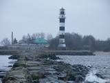 |
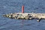
Die 860 m lange Westmole (gebaut 1885) regelt zusammen mit der Ostmole die Mündung des Flusses ins Meer und reduziert die Verschlammung. Eine Holzpfahlbauweise bildet die Gründung der Wasseranlage, die mit Steinen befestigt ist. Die Mole wurde mehrmals rekonstruiert und befestigt. Im 19. Jahrhundert befand sich auf der Mole ein Zuchthaus. Während des Wiederaufbaus der Mole wurde etwa eine Hälfte der Mole betoniert. Das andere Teil befindet sich zurzeit im recht schlechten Zustand! Schon 1528 hat der König von Polen Stephan Báthory einen Erlass über den Bau eines Leuchtturms an der Mündung des Flusses Daugava verabschieden. Die erste Karte, auf der der Leuchtturm dargestellt ist, stammt aus dem Jahr 1536. In der Leuchtturm-Abrechnung des Russischen Reiches im Jahre 1721 wurde angezeigt, dass sich hier eine Anhäufung der Steine befindet, auf der man Feuer anbrennt. Später wurden Türme aus Holz und Stein gebaut, die während der Kriegszeit vernichtet wurden. Der jetzige Leuchtturm von Daugavgrīva wurde 1957 gebaut und ist 35 m hoch. Ein Lichtblitz ist aus einer Entfernung von 18 Seemeilen sichtbar. |
|
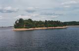 |
Before its flooding, the canyon of the Daugava River between Pļaviņas and Koknese was one of the most outstanding and beautiful parts of the Baltic terrain, and Oliņkalns hill was one of the largest castle hills in Latvia. The Andrejs cliff as up to 20 metres high, and it was part of the Daugava canyon. Before the area was flooded because of the construction of the Pļaviņas hydroelectric power plant, there were rapids near the hill that made it hard for rafters to sail down the river. Today it is a small island in the reservoir of the plant (it can be seen from the side of the Rīga-Daugavpils highway (A6) opposite Stukmaņi). It is separated from the shore by 300 metres of river, under which the Dūņas valley is now resting. A small part of the ramparts of the castle hill can still be seen on the island along with the ruins of an open-air stage and a few metres of the dolomite cliff that have remained above water. It is thought that the Alene castle was on the hill in the 13th century. Latvian mountain climbers installed a memorial stone in 1998 opposite Oliņkalns hill. |
|
 |
Dieser Hof ist ein der historischen Region Sēlija charakteristischer Hof mit seiner Planung und den typischen Gebäuden, und als solcher ist er einer der seltenen Höfe, der öffentlich zugänglich und zu besichtigen ist. Der Hof Gulbji befindet sich ziemlich weit von größeren Straßen und anderen Ortschaften. Er ist auf der sogenannten Insel Dronkusala, unweit von dem Ort zu finden, wo das Urstromtal von Dviete anfängt. Die Besitzer des Hofes haben viele alte Haushaltsgegenstände gesammelt. Die Besucher können hier die Wirtschaft und eine Sammlung von Heilkräutern besichtigen, sowie die Gerichte der Region probieren oder die Rauchsauna besuchen. Man kann sagen, dass die Besitzer des Hofes in einer Naturalwirtschaft wohnen, indem sie die Traditionen der historischen Region pflegen. Lettische Küche: Dünne Pfannkuchen, Graupensuppe, dickflüssige Kartoffelsuppe, geschmorte Bohnen in einer besonderen Soße, lettischer Grießpudding Buberts, Brotsuppe mit Schlagsahne, Torten, Kräutertees. Das besondere Gericht: Zeppeline. |
|
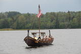 |
Um den Fluss Daugava aus einer anderen Sicht zu sehen, kann man vom Bäckerei-Geschäft der Firma „Liepkalnu maiznīca” eine Ausfahrt mit einem Langschiff der Wikinger „Lāčplēsis” machen, der gleichzeitig eine Gruppe von 24 Personen an Bord aufnehmen kann. Daugava war schon von alters her ein bedeutender Wanderungskorridor nicht nur für verschiedene Pflanzen- und Tierarten, die dadurch auf das jetzige Territorium Lettlands “gekommen” sind , sondern auch für Leute und Stämme, die die Daugava-Ufer und die Ostseeküste besiedelten. |


