
| No | Name | Description |
|---|---|---|
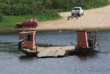 |
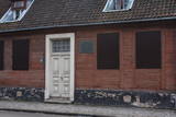
In the southern part of Līvāni, where Zemgales Street ends at the Daugava River, there is a fairly unusual and exotic form of transportation – one of three river crossings in Latvia. Unlike the one in Līgatne, this one is operated by a motor, not the flow of the river. It involves a cable across the river, and it is based on Soviet military pontoons that were used to build pontoon bridges for tanks. The crossing point was established by its owners. |
|
 |
The Dzīļu bakery in Malnava is a symbol of Krāslava and it is located next to the Malnava manor park. The lady of the house prepare hearty Lettigalian dishes and other country goodies. In the bakery the owner bakes different types of bread, for example, rye-bread, sweet-and sour bread, as well as makes cakes on pre-order. She also offers to groups and families to bake bread, pies, cakes or pizzas together. The tasting and Latgalian dishes in nowadays’style. A walk around the park of Malnava manor and stories about the white gate. Local bread is famous in Kārsava. The bakery offers brunch on weekends, as well as markets of local crafts and other products. |
|
 |
Viens no jaunākajiem Latvijā celtajiem mūra tiltiem. Tā akmens margas ir barona Karla fon Manteifeļa dāvinājums (celts 1907. gadā) Aizputei. Tilta ziemeļu puses margās ir iemūrēta granīta plāksne ar Manteifeļu dzimtas ģerboni, kas ir vāji izšķirams. |
|
 |
The estate owned by the dynasty of Baron Osten-Zaken was rebuilt in 1856 and 1857, because the old estate was sacked during the Crimean War (1853-1856). At the beginning of the war, British warships bombarded Latvia's shoreline and ships with the purpose of scaring the Russian tsar. Some of the gunfire hit Kolka, which was part of the Russian Empire at that time. After the estate was destroyed, the so-called White House was built there with a series of ancillary buildings. A mantel chimney was installed on the second floor, and it was used to smoke wild game (the chimney is still there). The estate belonged to the aristocrats until 1919, when its last owner, Christian von Osten-Zaken, was shot in Tukums. An elementary school, known as the Kolka School, was installed in the White House in 1929. It remained open until 1961, when a new school was built. Crafts lessons were offered at the building until 1989, at which time it was known as the Old School or the Small School. In 1991, the Old School was taken over by the Faculty of Biology of the University of Latvia, and it has been used for summer internships for students ever since 1994. |
|
 |
The saloon is in the former home of the governor of the Koknese Estate. It is named after the Latvian author Rūdolfs Blaumanis, who studied at the estate and lived there for two years. There is an outdoor terrace, and it is possible to hold celebrations there. Latvian cuisine: Potato salad, herring salad, bean salad Valmiera salad, beef with onions, pork ribs, homemade steak haché, roast beef with horseradish sauce, baked liver, herring with cottage cheese, oatmeal dessert. Special foods: “Saloonkeeper’s slice”. |
|
 2 days
|
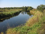
The Gauja is the most beautiful river in Latvia, with an impressive river valley that is up to 80 metres in depth. Picturesque sandstone outcrops rise above the river. The Gauja is a calm river, with just a few small rapids. Leisure boating is perfect here. Between Cesis and Sigulda, the Gauja flows through the Gauja National Park . There are several well-appointed facilities for boaters on the banks of the river, with benches, tables, places for campfires, firewood and information stands.Several interesting heritage sites on the way - Ligatne Oldfashioned ferry, Turaida medieval castle and Krimulda Manor. |
|
 |
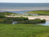
Palieņu un mitrās pļavas abos Dubnas upes krastos, kuras nelielā posmā var vērot no Rožupes - Vārkavas ceļa. Piemērotā laikā šeit dzirdēsiet griezes balsi, kas ir Eiropā izzūdoša putnu suga.
|
|
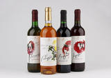 |
This venue produces homemade fruit, berry and dandelion wine from local products and with no preservatives, as well as interesting products such as spicy plum sauce and fruit and berry conserves. Groups of tourists can go on a tour and taste and purchase the products. |
|
 |
Reta galda vīnogu kolekcija un degustācija, ainaviska dārza apskate un stāstījums par ķirbjaugu, čilli un tomātu šķirņu kolekciju. Kolekcijā ir 120 šķirņu tomātu, 20 šķirņu paprikas un aso piparu, 140 šķirņu ķirbjaugu. Degustācijas galds - sukādes, čilli, interesanti ievārījumi un pašu fermentētas tējas. |
|
 |
This farm has 36 ha of land and is near Latvia’s border with Belarus. It raises goats and obtains some 10 tonnes of milk from them each year. The milk is processed at the farm, which offers cottage cheese, cream, various kinds of cheese, homemade ice cream and meat products. Tastings are offered, and visitors can help to do the work at the farm. The farm is part of the Latgale network of culinary heritage and is a biological farm. |
|
 |
The factory produces milk candy “Gotiņa”, toffee, sherbet, marmalade and candy cream from natural ingredients. We obtain fresh milk from local farms; other ingredients for the production process are obtained in the surrounding area. Each piece of candy “Gotiņa” is hand-wrapped. |
|
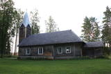 |
The Lode (Apši) Lutheran Church is between Lake Bānūži and Lake Ilze. It is a unique example of wooden architecture and dates back to 1780. The log church had a straw roof until the early 20th century, at which point a shingled roof was installed instead. |
|
 |
For more than 60 years, ice-cream is made in the historic Rūjiena dairy house, built in 1912. Everyone is kindly invited to take a tour and learn about the ice-cream of Rūjiena, watch the video about the manufacturing process, and, of course, enjoy Rūjiena ice-creams. |
|
 |
This is a homestead that is three km from the centre of Vecpiebalga and is in a lovely place – the Incēni hill. There is a museum here featuring the author of the legendary fairy tale “Pussy’s Mill” by Kārlis Skalbe (1879-1945). The poet and prose writer built the building in 1926 and spent summers there from that year until 1944. The museum was opened in 1987. The western slope of Vaktskalns hill right alongside the museum offers a lovely view of Lake Alauksts. The cremated remains of Skalbe and his wife, Lizete, were reinterred at the location in 1992 from Sweden, where the poet died. There is a unique monument to them in the form of a stone boat. |
|
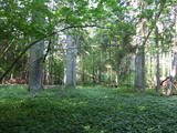 |
The Ukri forest on the border of the Dobele district is what is known as a vast forest. It has oak trees (including many huge ones), linden trees, oak trees (large stands of oak are uncommon in Latvia), and other deciduous trees. A small area of the forest can be toured in the company of a guide to look at the animals of the area and their importance in the flow of nature. The restricted area protects forest habitats, plants and animals, including many that are typical of the southern areas of Latvia. |
|
 |
Находится на ул. Кунгу, д. 24.Одно из старейших зданий города - деревянный сруб с черепичной крышей, построенный во второй половине XVII века и прозванный в народе гостиницей мадам Хойер. Здесь в 1697 году во время путешествия «Великого посольства» в западную Европу останавливался (инкогнито) русский царь Петр I. Находящееся по соседству здание на ул. Кунгу, д. 26, является вторым старейшим жилым зданием Лиепаи (1699 г.) – жилой дом бургомистра города. Во время Северной войны здесь останавливался король Швеции Карл XII. Оба здания подлежат осмотру только снаружи. |
|
 |
A small beer brewery and shop in Lielvārde that organises tastings and offers to taste Latvian delicacies on-site and to purchase them for take away. |
|
 |
"Līdumkalni" atrodas Ķurbē -Kurzemes ziemeļrietumu daļā, starp Dundagas mežiem un Ķurbes lielo silu, zaļu pakalnu vidū, 15 km no jūras un ne pārāk tālu no debesīm. Šeit laiks rit lēni. Tas nevienu nesteidzina. Laika pietiek, lai vērotu Dieva radīto pasauli un ieskatītos Viņa bagātajā aptiekā. Laika pietiek lai iepazītos ar kristīgajām tradīcijām un dzīvesveidu, lai iegūtu praktisku lūgšanu un meditāciju pieredzi. Laika pietiks arī veselīgas maltītes pagatavošanai lauku virtuvē vai uz ugunskura un pašam savas gleznas uzgleznošanai gleznotājas darbnīcā. |
|
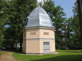 |
The creamery or clock tower (so known because a clock was installed in the round roof window of the structure) is near the gate to the Naukšēni Estate. The eight-corner brick building has a domed roof that is covered with tin. The clock tower has two floors. The second is easily ventilated because of small windows on all sides of the building. The creamery is seen in a picture drawn by J.K. Brotze around 1800. It suggests that the building has not lost its initial shape even today. The tower deteriorated during the Soviet era, when a barn was attached to it and a large gate opening was broken into it. In 2002, the tower was renovated (architect Inese Maurāne). The interior preserves the historical brick floor and the stairs to the second floor. Historical objects are displayed in the creamery, and today it is one of the main tourist attractions for the Naukšēni Estate. |
|
 |
This is another important territory for the protection of reefs, is also opposite the Salacgrīva Administrative District, and covers 7,239 hectares.
|
|


