
| Nr | Nosaukums | Apraksts |
|---|---|---|
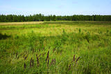 |
Teikām un nostāstiem apvīta vieta par šeit kādreiz
esošo Vīdala (Dieviņa) ezeru, kura ūdens 1838. g. tika nolaists jūrā. Interesanti,
ka ezera dibenā pēc ūdens nolaišanas atrada senas celmu un kuģu atliekas.
|
|
 |
Liegums veidots ar mērķi saglabāt ar vecupēm un pļavu biotopiem un to apdzīvotājiem bagāto un mazietekmēto Ogres ielejas posmu, kura teritorijā atrodas Latvijā reti sastopamās gobu un vīksnu audzes. Dabas liegums atrodas Ogres ielejas dabas parkā (sk. sadaļu "Dabas parki").
|
|
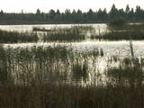 |
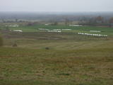
Kaut arī Sedas tīrelī jau no pagājušā gadsimta vidus iegūst kūdru, tā ir viena no Latvijas nozīmīgākajām NATURA 2000 teritorijām ar lielu ainavu, biotopu un bioloģisko, īpaši – putnu, daudzveidību. Potenciāla putnu vērošanas vieta migrāciju laikā. Šajā nolūkā purva malā izveidoti skatu torņi. Cauri purvam kvadrāta veidā stiepjas šaursliežu dzelzceļa uzbērums, kas kopā ar ritošo sasatāvu ir Latvijas industriālā mantojuma piemineklis. No tūrisma viedokļa interesanta ir ārpus lieguma teritorijas esošā Sedas pilsēta.
|
|
|
|
Ļoļu Velna pēdas akmens atrodas Mākoņkalna pagasta teritorijā. Atrodas nelielā meža pļaviņā,
pārdesmit metru no grāvja, kas iezīmē Rēzeknes un Krāslavas novada robežu. Tas ir ap 1,9 m augsts
noapaļots konuss ar pamata perimetru 1,8 m. Kādreiz akmenī esot bijis pakava nospiedums, tagad rēgojas
nenoteiktas formas izdrupums. Bet lielisku pakava zīmi kāds „mākslinieks” tīšuprāt sabojājis. Pirmo reizi
akmens kā ģeoloģisks piemineklis reģistrēts 20. gs. trīsdesmitajos gados. Toreiz citā administratīvā teritorijā
– Rēzeknes apriņķa Andrupenes pagastā.
|
|
 |
Atrodas Dunduru pļavu ziemeļdaļā - Melnragu rīkles galā. Uzbērts mākslīgi, izlīkumojot Slampes upītes gultni. No kurgāna pārskatāmas pļavas ar dzīvei savvaļā pielāgotajiem mājlopiem, kā arī neliels atjaunotās Slampes posms. Interesants skats būs palu laikā, kad applūst apkārtējās palienes. Putnu vērošanas vieta.
|
|
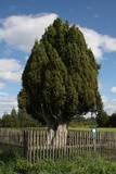 |
Resnākais Latvijas un Baltijas valstu kadiķis (Juniperus communis). Aug lauka vidū, ļoti ainavisks. Koku sauc arī par Rietekļa kadiķi, jo zem tā labprāt sēdējis latviešu dzejnieks Rieteklis (Jūlijs Eduards Balodis (1856. – 1940.)).
|
|
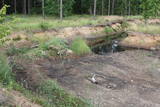 |
Dabas liegums veidots veca un aizaugoša grants karjera vietā, kuru apdzīvo Latvijā reta abinieku suga – smilšu krupis. Karjeriem aizaugot arī samazinās smilšu krupju daudzums (tiem vajadzīgas arī atklātas smiltāju – grants platības), kas uzskatāmi parāda apstākli, ka bieži vien konkrēta suga ir saistīta ar tikpat konkrētu cilvēka saimnieciskās darbības formu un cilvēkam aizejot, nereti pazūd arī dabas vērtības. Ir ļoti maza cerība šo abinieku sastapt dabā, vienkārši ieejot lieguma teritorijā, tādēļ pieņemsim šo faktu zināšanai un attieksimies pret liegumu kā Latvijas mērogā īpaši saudzējamu.
|
|
 |
„Ainaži – Salacgrīva” - nozīmīga teritorija rifu aizsardzībai. Teritorija atrodas iepretim Salacgrīvas novadam, tās platība ir 7239 ha.
|
|
 |
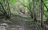
Tās garums ir aptuveni 1,2 km. Taku unikālu padara paugurainais meža reljefs (gravas augstums vietām sasniedz pat 15 m), augu sugu daudzveidība, kā arī gleznainie Kauliņupītes līkumi, kas divās vietās šķērso taku. Žibgravas veselības taku izveidoja 90. gadu beigās. |
|
|
|
Vienīgajā Cieceres ezera salā izveidojies cilvēka mazietekmēts mežs, kurā dominējošās koku sugas ir ozols, liepa un oši. Daži no ozoliem ir sasnieguši dižkoku izmērus. Nozīmīga dzeņveidīgo sugu dzīves vieta. Nelabiekārtota, tādēļ vislabāk to apskatīt, neizkāpjot no laivas. |
|
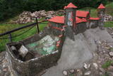 |
Naujenes pilskalns veidots līdz 25 m augstā un stāvā Daugavas ielejas krastā, ko ietver divas sānu gravas. 1275. - 1277. g. Livonijas ordeņa mestra Ernesta fon Rācenburga vadībā agrākās latgaļu koka pils vietā uzceļ mūra pili. Tajā varēja iekļūt pa paceļamu tiltu, šķērsojot ārējo un iekšējo priekšpili. Līdz 16. gs. vidusdaļai pils kalpo kā Dinaburgas komtura rezidence. 1577. g. to noposta Ivana Bargā karaspēks. Pēc šī notikuma Dinaburga zaudē savu stratēģisko nozīmi, un jaunas nocietinātās būves celtniecība tiek uzsākta vietā, kur tagad atrodas Daugavpils. Blakus ordeņa pils drupām uzstādīts samazināts pils makets, kas palīdz iztēloties, kā šeit izskatījās pirms daudziem gadsimtiem. Līdz pilskalnam no autostāvlaukuma var nokļūt pa labiekārtotu taku. No pilskalna paveras viens no skaistākajiem Daugavas loku dabas parka skatiem. |
|
 |
No torņa Engures ezera austrumu krastā (blakus dzīvei savvaļā pielāgoto mājlopu ganības, piebraucams no Bērzciema puses), atklājas skats uz ezera ziemeļaustrumu daļu – niedrājiem, saliņām, Lielo salu, govīm un zirgiem. |
|
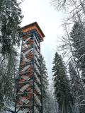 |
Dabas liegumā "Lielie Kangari" atrodas 33 metrus augsts skatu tornis, kura virsotnē atrodas platforma, no kuras paveras skats uz Kangaru ezeru un Lielkangaru purvu. Dabas liegumā izbūvēta arī nepilnu divu kilometru gara pastaigu taka ar tiltiņiem un skatu platformu pie ezera. Takas sākumā izvietotais veselības maršruts ikvienu apmeklētāju aicina kārtīgi izvingroties un izkustēties. Apmeklētāju informēšanai un izglītošanai visas takas garumā izvietoti arī informatīvie stendi ar fotogrāfijām, kas apvieno varenu stāstu un teiku kopumu par notikumiem, vietām, tēliem un parādībām dažādās apkārtnes vietās. |
|
 |
Atrodas Daugavas labajā krastā, ap puskilometru no Skrīveru Zemkopības institūta. Šajā vietā stāvo Daugavas ielejas krastu „pāršķeļ” dziļā Ašķeres strauta grava. Pilskalns bijis apdzīvots jau no 1. g. t. pr. Kr., par to liecina tajā atrastas latgaļu un lībiešu senlietas. 13. gs. pilskalnā slējās mūra pils, ko nopostīja 17. gs. Par tās esamību mūsdienās nekas vairs neliecina. No pilskalna, ko dēvē arī par Kraukļu kalniem, paveras viens no skaistākajiem Daugavas vidusdaļas skatiem. No tā (Rīgas virzienā) redzama Senbaznīcas vieta (attīrīts laukums ar baltu krustu). Gar Ašķeres strauta krastiem izveidota pastaigu taka. Tuvākā pilskalna apkārtne ir labiekārtota, kopumā ir izveidotas četras takas. Garākā no tām ir Daugavas taka (10 km). |
|
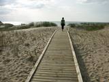 |
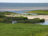
Taka iepazīstina ar Rīgas teritorijā esošo dabas lieguma zonu, kas veidota jūras piekrastes biotopu (meži, pļavas, niedrāji, kāpas) un Daugavgrīvas pļavās dzīvojošo putnu aizsardzībai. Daugavgrīva labi pārskatāma no putnu vērošanas torņa, kas pielāgots cilvēkiem ar īpašām vajadzībām. |
|
 |
Ziemeļos no Viļāniem (Jaunviļānos) atrodas ar mežu apaudzis osveidīgs paugurs – t.s. Kaupra kalns, kurā virsotnē meklējams (ceļa uz Trūpiem malā izvietota norāde) minētais akmens. Trīsdaļīgā akmens, kas atrodas mežā, garums ir 4 m, platums 3 m, augstums 1,9 m. Lielākās daļas virspusē var saskatīt nelielu dobumu, tādēļ pastāv viedoklis, ka šis ir sens kultakmens. |
|
 |
No Elkas kalna (viens no augstākajiem Vidzemes augstienes rietumdaļas punktiem) paveras plašs un skaists skats ziemeļu virzienā. Te neliels stāvlaukums, retranslācijas tornis un iedomātais Gaujas sākums.
|
|
 |
Latvijas augstākajā un Baltijas otrā augstākajā punktā, diemžēl atrodas tikai torņa grausts! Tādēļ labākie skatu punkti jāmeklē pašam. Tie daļēji atklāsies no torņa apkārtnes un slēpošanas trasēm, īpaši no Lielā un Mazā Golgāta. Vērts izstaigāt arī Gaiziņkalna dabas taku.
|
|
 |
Īdeņas pilskalns atrodas Lubāna ezera ziemeļrietumu stāvajā nogāzē
pret Lubāna ezeru, zemes izvirzījumā starp nelielām graviņām. No tā
paveras lielisks skats uz ezeru un klāniem. Ir bijis apdzīvots no 11. gadsimta.
|
|
 |
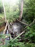
4 km garā un marķētā taka iepazīstina ar dziļo Imulas ieleju – Abavas kreisā krasta pieteku. Īpaši iespaidīga ieleja izskatās bezlapu periodā, kad ir apjaušami tās izmēri un formas. Vēstures cienītāji var upes gultnē uzmeklēt Langsēdes Velna pēdas akmeni. Atrodas dabas parkā „Abavas senleja”. |
|


