
| No | Name | Description |
|---|---|---|
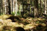 |
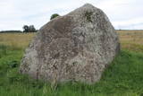
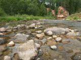
The forest around Kaltene features a natural miracle – the rocks of Kaltene, which are also known as the barrier rocks. The rocks are 2-3 m from the sea and date back to the Ice Age. The Devil’s rock is the largest one. It used to be a beautiful pile of rocks that “stretched to the tops of the trees.” In older maps it is described as being 20 m high. It had many natural rocks, including some that were completely round, while others resembled plates. The rock was almost completely destroyed in the 1960s and 1970s, when it was chopped up to build roads. A fairly small part of the rock survives today, and it is 300 m long and 2 m high. Scientists believe that these rocks used to be sacred locations, because there are many legends and stories about them. There is a forest path with wooden pathways, information stands and a small car park there. (Source: Roja TIC) |
|
 |
Brīvdienu mājas "Korķi” apkārtnes priežu mežā ir izveidota Jāņtarpiņu taka. Ideāla vieta aktīviem sēnotājiem un ogotājiem. Savukārt saules un jūras cienītāji pa šo taku 5-10 minūšu gājienā nonāks Vitrupes pludmalē, kur varēs baudīt sauļošanās un peldēšanās priekus.
|
|
 |
In 2006, a wooden pathway was installed across the Planči swamp – 500m long, which means that the visitor will spend around 20 minutes there. This is probably the only nature trail in Latvia for which there are plans to post information in Braille for people with impaired vision.
|
|
 |
The castle hill of Spriņģi. It is located near Rēzekne town and it is
interesting with its peculiar shape of the ruins.Archeological monument of local significance.
|
|
 |
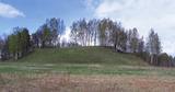
Zilais (Blue) Hill is the highest point in the Idumeja highlands – it is a very distinct hillock covered by forest, and from it there is a “narrow” landscape featuring the northern part of the highlands, as well as the Burtnieks flatlands. The restricted area is there to protect habitats such as gullies, hillsides and the boreal (northern) forest of the area. Zilais Hill is a popular tourist destination.
|
|
 |
Atrodas 4,5 km ziemeļos no Rīgas – Daugavpils šosejas (A 6), klajā laukā (ap 3 m augsts, ainavisks). Viens no izcilākajiem Latvijas muldakmeņiem, tādēļ ir vērts izmest kādu loku. Akmens augšdaļā ir iekalts gandrīz 2 m garš un ~ 20 cm dziļš muldveida iedobums. Atrodamas ziņas, ka vēl 19. gs. vidū pie akmens ir ziedots ēdiens, monētas u.c. priekšmeti. Pie tā dedzināti ugunskuri un svinēti svētki. Teikas vēsta, ka velns muldā lējis ūdeni un gribējis mīcīt mīklu, kā arī parāvis zem akmens tuvējo māju saimnieku. |
|
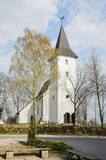 |
The Priekule Lutheran Church was built around 1680 and rebuilt a century later, in 1892. In 2005, the church tower was improved, and visitors to the church can now use it as a viewing platform. They can see the place where Icarus of Priekule supposedly made his first “flight.” |
|
|
|
The only island in Lake Ciecere has a more or less virgin forest of oak, linden and elm. Some of the oaks are huge. This is an important habitat for woodpecker-type birds. The island has not been improved. |
|
 |
The forests of Zvārde are located on land which used to be a Soviet air base. The territory was unpopulated and was not accessible to civilians. The vast area includes various types of forest - boreal forest, bogs of black alder, etc. The fact that the military used to control the territory is one of the reasons why the forests of Zvārde are a location where many rare and protected birds live, reproduce and find food. Some of the elements of the old air base are still in place, including a unique surveillance platform. It is recommended that visitors to the area drive only along general use roads. |
|
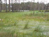 |
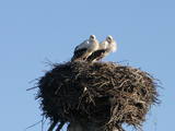
This is one of the largest areas of swampland in Latvia, lying between Lake Babīte and Olaine. Most of the area is still made up of peat. Relatively untouched is the northern part of the swamp, where there is a lovely set of swamp lakes, featuring landscapes of moss swamps. The heath is one of the few swamps in Latvia where the western-type and eastern-type swamp coexist. This is an important location for protected birds. A nature trail and viewing tower are to be installed at the heath in the near future.
|
|
 |
Kalētu muižas bijušais medību dārzs. Muižas laikos šeit ierobežotās platībās turēja meža dzīvniekus, kuru medības bija populārs muižniecības izklaides veids. Parkā uzmeklējams piemiņas akmens Krievijas imperatoram Aleksandram III, kurš šeit nošāvis briedi (irsi). No Kalētiem Latvijas teritorijā „ienāca” staltbrieži, kurus medību vajadzībām 1848. g. atveda no Vācijas. Parkā izveidotas takas un atpūtas vietas. |
|
 |
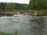
This is the widest water fall in Latvia – 249 metres wide and up to 1.75 metres high. This is an interesting natural, cultural and historical object in that it is linked to various events and legends. Duke Jacob of Courland invented equipment to catch fish. It was fastened to the cliffs of the waterfall, and this created the tale of a city where salmon and other fish who were leaping across the waterfall fell into the nets and were thus caught in the air. During Jacob’s rule, there was talk about digging a canal around the waterfall to ensure shipping, and work began on the project. During the early 18th century there was the idea that the Baltic Sea and the Black Sea could be connected via the Venta, Nemuna and Dnieper rivers. Turkish prisoners of war continued to dig the canal, but the local dolomite cliffs were a problem. Attempts to blow up the cliffs led to damage to nearby buildings, so the work ended. The impressive ditch can still be seen today. In 2012, a wooden pathway was installed on the right bank of the Venta to offer a good look at the waterfall. It is worth visiting here during various seasons of the year, when different types of fish migrate. |
|
 |
This lovely territory includes the hillocks of Embūte, which are in the ancient Embūte valley. The aim of establishing the park was to protect the landscape, biotopes and species of the region. An ecological tourism trail has been established in the valley, as has a forest trail through the nature park (accessibly only in the company of a guide). Visitors will learn about the hillocks and ravines left behind by the Ice Age. The ravines and the forests along their sides are protected biotopes. There are also important natural and cultural monuments, including the Embūte castle hill and the ruins of a baronial estate, castle and church. Other points of interest include the death place of the Courlandian warrior Indulis, the Joda dam, meadows, a viewing tower, etc. Three unmarked bicycle trails are in the area. |
|
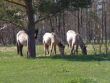 |
Für den Zweck der Bewirtschaftung der Niederungsauen des Pape-Sees und der Vermehrung der biologischen Vielfalt sind hier Konik-Wildpferde angesiedelt wurden. Die kann man mit einem örtlichen Guide kennenlernen. |
|
 |
The Amata is one of Latvia's swiftest river, and water tourists congregate there each spring to engage in extreme activities. From the Rīga-Veclaicene highway, the Amata flows into a deep valley, with an average drop of more than 3 m/km or, downriver, as much as 8-10 m/km. Water tourists usually use the segment of the river between Melturi and the Zvārte cliff or the Veclauči bridge that spans the Līgatne-Kārļi road. Please remember that the Amata is not a friendly river for beginners. After lengthy rainfall, the river can be navigable during other times of the year, as well. The surrounding valley is attractive because of impressive sandstone and dolomite cliffs, among which the best known are the Vizuļi cliff (which can be the site of beautiful frozen waterfalls in winter), the Ainavu cliff, the Ķaubju cliff, the Dzilna cliff, the Zvārte cliff, and the Lustūzis cliff. Between Melturi and Veclauči, there is the Amata geological trail, which is marked with orange paint on tree trunks. There are three segments to the trail – from Melturi to the Kārļi fish farm, from the fish farm to the Zvārte cliff (both segments can be extreme!), and from the Zvārte cliff to the Veclauči bridge. You can hike the trail at any time except when there is deep snow. The most impressive views will be found when the trees are bare. If you boat down the river, you will not have time to look at or photograph the cliffs, because all of your attention will be focused on the river itself and the obstacles therein. |
|
 |
Viens no lielākajiem cilvēka veidotajiem Latvijasparkiem (70 ha), kas izstiepies no Liepājas ostas līdz Dienvidu fortam > 3 km garumā. Tā izveidi uzsāka jau 1870. g. pēc pilsētas mēra K. Ūliha iniciatīvas, uzbūvējot kūrmāju un strūklaku. 19. - 20. gs. mijā ap Dzintaru un Liepu ielām parādījās greznu villu un savrupmāju apbūve. Viena no skaistākajām ir jūgendstilā celtā savrupmāja Liepu ielā 27, kurā atrodas Krievijas ģenerālkonsultāts. Ēkai ir slēgta uzeja, balkoni, pildrežģa konstrukcijas un kārniņu jumts (arhitekti G. Jenike un P. M. Berči). Jūrmalas parks visās sezonās ir iecienīta pastaigu un dažādu aktivitāšu norises vieta. Te meklējams stadions „Daugava”, tenisa korti, koncertestrāde “Pūt, vējiņi!”, vasaras kafejnīcas, minigolfa laukums, bērnu rotaļu laukums, skeitparks. Šeit meklējamas lielākās Latvijas bungas – vides dizaina objekts. |
|
 |
A restricted area with a set of artificial ponds to the South-west of Saldus. The ponds attract many different kinds of birds during nesting and migration season. The location has not been improved for tourist purposes, but it is still an interesting place for some bird-watching. The forests around the ponds are also home to many protected birds and species of bat. |
|
 |
Pie Gārsenes pils atrodas bijušais muižas parks 4ha platībā un pie tā sākas arī Gārsenes dabas takas. Dabas takas vēsturiski tika veidotas vienlaicīgi ar pils kompleksa būvniecību un ieeja takās atrodama pie mākslīgi veidotā, ar bruģa pamatni izliktā barona peldēšanās dīķa. Takas sākumā saglabājusies ošu aleja, ko savulaik stādījis barona dārznieks, savukārt taku vidusposmā apmeklētājiem ir iespēja pasēdēt uz Barona krēsla - akmens ar cilvēku veidotu sēdvietu tajā. Kopumā Gārsenes mežā vijas dažāda garuma labiekārtotas pastaigu un izziņas takas - Kultūrvēsturiskā taka, Zaļā taka, Baronu pastaigu taka, Staburaga taka, ar ierīkotām atpūtas un ugunskuru vietām. Takās apskatāmi vairāk kā 40 unikāli dabas objekti, gan dižakmeņi, gan dižkoki, kā arī un pagasta ievērojamākie arhitektūras un kultūrvēstures pieminekļi. No 2016.gada maija Dabas takās ietilpst arī „Krēslas stundas taka”, kas īpaši patiks zinātkāriem mazajiem ceļotājiem. Taka stāsta par Rūķu dzīvi mežā un tās veidošanas pamatā ir stāsti no „Lielās Rūķu enciklopēdijas”. |
|
 |
This is a territory that is unique at the Latvian and the Baltic level, one which stretches from Valmiera to the Gulbene District. Here we find the irregular Gauja River valley with a dense system of ancient rivers. The meadows on the banks of these rivers are important in terms of biological diversity. There are stands of oak and broad-leaf trees. Many rare and protected birds live and next here – the corn-crake, the woodpecker, etc. The territory is excellent for bird watching, nature studies, ecological tourism and various kinds of active tourism. |
|
|
|
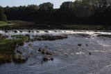
Atrodas Lubāna dienvidu krastā pie dambja un Īdeņas kanāla, no kura var aplūkot „tipiskas” mitrāju ainavas – niedrājus, aplūstošus krūmājus, mitras pļavas, aizaugušo ezeru. |
|


