
| Nr | Name | Beschreibung |
|---|---|---|
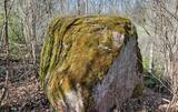 |
The Boulder of Labvārži is located in the Northern side of Adamova Nature Park, in the SW of Lake
Vizulītis (Labvārži). It is located 0,70 km from the Labvārži or Laboržu House. The boulder is 5.9m long and
4,0 m wide.
|
|
 |
Pie Gārsenes pils atrodas bijušais muižas parks 4ha platībā un pie tā sākas arī Gārsenes dabas takas. Dabas takas vēsturiski tika veidotas vienlaicīgi ar pils kompleksa būvniecību un ieeja takās atrodama pie mākslīgi veidotā, ar bruģa pamatni izliktā barona peldēšanās dīķa. Takas sākumā saglabājusies ošu aleja, ko savulaik stādījis barona dārznieks, savukārt taku vidusposmā apmeklētājiem ir iespēja pasēdēt uz Barona krēsla - akmens ar cilvēku veidotu sēdvietu tajā. Kopumā Gārsenes mežā vijas dažāda garuma labiekārtotas pastaigu un izziņas takas - Kultūrvēsturiskā taka, Zaļā taka, Baronu pastaigu taka, Staburaga taka, ar ierīkotām atpūtas un ugunskuru vietām. Takās apskatāmi vairāk kā 40 unikāli dabas objekti, gan dižakmeņi, gan dižkoki, kā arī un pagasta ievērojamākie arhitektūras un kultūrvēstures pieminekļi. No 2016.gada maija Dabas takās ietilpst arī „Krēslas stundas taka”, kas īpaši patiks zinātkāriem mazajiem ceļotājiem. Taka stāsta par Rūķu dzīvi mežā un tās veidošanas pamatā ir stāsti no „Lielās Rūķu enciklopēdijas”. |
|
 |
Dieses morastige Gebiet war Teil der Litorina - Meereslagune und ist ein Gebiet, wo es viele seltene und geschützte Vögel gibt, z.B. leben und nisten hier Spechte. Ein Teil des Territoriums kann von der Straße Tukums-Kolka aus überblickt werden.
|
|
 |
This territory is around 9 square kilometres in size and is found to the North of the village of Kūdra, where the so-called old peat quarries are found. Peat was extracted here during the first period of Latvian independence. Today the territory is overgrown, preserving the old and flooded quarries which offer a very unusual landscape. The best way to examine them is on foot or bike, taking the road from the Kūdra railroad station which leads to Lake Sloka. |
|
 |
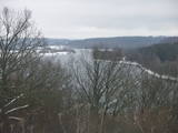
This is the highest point in the Latgale highlands (289 metres above sea level), opening up a narrow but lovely view of Lake Rāzna and the massive forests of the highlands. You really should visit this hill when the sun is setting beautifully!
|
|
 | ||
 |
In Vecslabada, there is a peninsula among Lake Dziļezers, Lake Audzeļi, and Lake Istra. From the highest point on the peninsula, you will see a truly unusual view of the land of the blue lakes – lake islands, as well as the village of Vecslabada with its church towers. The Lake Istra nature reserve is nearby.
|
|
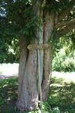 |
This is the thickest and tallest common ivy in Latvia. It is in the park of the Zentene Estate, opposite the mansion (which is now a school).
|
|
 |
Es ist ein einzigartiges Naturgebiet und kulturgeschichtliches Gebiet zwischen Kaldabruņa, Bebrene und Dviete. Durch das Urstromtal fließt der kleine Fluss Dviete, der die Seen Skuķu ezers und Dvietes ezers und die Wiesen der Flussniederung durchquert. Während der Hochwasserzeit arbeiten diese Wasserbecken als Reservoir für die Gewässer des Flusses Daugava, weil sie umfangreiche Hochwassermassen schnell aufnehmen und später langsam zurückgeben können. Wenn es im Frühling sehr viel Wasser gibt, dann ähneln die hier sichtbaren Landschaften keiner anderen in Lettland. Diese Besonderheit der Wasserstandschwankungen ist der Grund, warum dieser Ort für Pflanzen und für Vögel während der Migrations- und Nistzeit von Bedeutung ist. Zum Schutz des Gebietes ist der Naturpark der Flussniederung von Dviete eingerichtet worden. Es ist interessant, dass die höheren Stellen, die während des Hochwassers nicht überschwemmt werden, Inseln genannt werden. Im Urstromtal von Dviete sind 15 eventuelle alte Siedlungen (aus der Steinzeit, Bronzezeit und Eisenzeit) gefunden und viele Zufallsfunde mit verschiedenen Gegenständen ausgegraben worden. Man hat allen Grund zu glauben, dass dieser Ort einer der ältesten und bedeutendsten Wohnorte auf dem heutigen Gebiet von Südlettland ist. |
|
 |
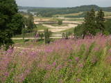
At the Aizkraukle Lutheran church along the upper part of the shores of the ancient Daugava River valley, there is a bit of an old road from which one of the most beautiful views of the central section of the river can be seen, particularly when the trees are bare. Approximately one kilometre to the North-west is the Aizkraukle castle hill, which offers a no less impressive view.
|
|
 |
Latvia’s highest hill is the second highest in the Baltic States, but alas, it has only a wrecked viewing tower, so you’ll have to look for the best views on your own. You’ll find some around the tower and the ski trails, particularly Large and Small Golgotha. It is worth hiking the Gaiziņkalns nature trail.
|
|
 |
Die Grüne Düne – Nach den Krāču Hügeln ist dies
die zweite ausgeprägteste Dünenbildung im Nationalpark
Ķemeri, die in mehr als drei Kilometer länge das
Hexenmoor von dem Grünen Moor trennt. Am Fuß der
Düne windet sich ein alter Erdweg, auf dem die Strecke
verläuft. Während Sie entlang der Grünen Düne
wandert, benutzen Sie bitte nur vorhandene Pfade!
|
|
 |
From the Asote castle hill, which is on the right bank of the Daugava River near Jēkabpils, there is a fine view of the Daugava River valley, the Ābeles Island, and the Kaupre castle hill that is at the northern end of the island.
|
|
 |
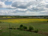
To the North of the Cesvaine Castle is a park that is crossed by the rapidly flowing Sūla River. The Cesvaine castle hill is on the northern bank of the river, is around 15 m high and is covered by trees today. The grave of the owner of the castle, Adolf von Wolff, is there. It is said that he wanted to have his casket dragged to the gravesite on a sled. He died during the summer, but that was done anyway. The park features a wide diversity of trees and bushes, some of which the owner brought home from his extensive travels. |
|
 |
Nature restricted area includes eastern side of the lake with Lanupe River and North-east and South-east coastal areas. Restricted area has been established for protection of birds and floodplain meadows of the lake. To see the nature restricted area visitors do not have to enter it. There are great view points with wind generators of Grobina on the background from the road Vecpils – Rava – Aistere. Coastal areas which are not included in the restricted area are perfectly suitable for bird watching. There is located the smallest city by its population in Latvia to the South from the lake.
|
|
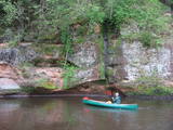 |
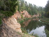
The Brasla River flows through a lovely valley that is approximately 300 m wide and up to 30 m deep. It is near the Inčukalns-Valka highway. The river has among the most beautiful rapids in the country, with mighty cliffs (the Brasla cliffs) that can be seen at nearly every curve in the river (except along the lowest reaches of the river). During the winter, various unusual frozen waterfalls can be seen in some of the cliffs, including the Krauļukalns cliff and the Jāņavārti cliff. On the left bank of the Brasla, opposite the Brasla fish farm, there are the Aņīte cliffs -- a series of sandstone cliffs that are 1 km long. The cliffs are between 2 and 35 m in height, and the sandstone cliffs are separated by ravines. On the right bank of the Brasla, there are major cliffs such as the Vāršavu cliff, the Kraukļukalns cliff, the Jāņavārti cliff, the Slūnu cliff, the Virtaka cliff and the Buļi cliff. How can you best learn about them? Boat down the river from the aforementioned highway or even from Straupe, which is further upstream. An alternative is hiking down the right bank of the river, though please take into account that the terrain is fairly extreme, and you are going to have to think about what to do when you arrive at the place where the Brasla River flows into the Gauja. |
|
 |
The Neļķes cliffs are in Skaņākalns Park, and they offer the most beautiful view of the Salaka River valley, with its sandstone cliffs and peaceful river. There are good views from the “devil’s pulpit.” It’s worth visiting the Skaņamkalns Hill to check out the views from the famous echo cliff. This is part of the ZBR.
|
|
 |
Die Wälder von Zvārde befinden sich auf einem ehemaligen sowjetischen Luftstützpunkt. Das Gebiet war nicht bewohnt und für Zivilisten nicht zugänglich. Auf dem riesigen Gelände gibt es verschiede Waldarten – Nadelwald, Schwarzerlensümpfe usw. Die Tatsache, daß das Militär dieses Gebiet kontrolliert hat, ist der Grund dafür, daß in den Wäldern von Zvārde viele seltene und geschützte Vögel leben, brüten und Futter finden. Einige Teile des alten Luftstützpunktes sind noch vorhanden, wie z.B. eine Überwachungsstation. Es wird empfohlen, daß sich Besucher nur auf den allgemein benutzten Straße bewegen.
|
|
 |
The classical skyline of Old Rīga can be enjoyed from several locations – Mūkusalas Street, between the railroad bridge and the stone bridge, from the stone bridge, from the A-B dam, from the grounds of the central office of the Swedbank bank, from the Vanšu bridge, and from the Ballast Dam at Ķīpsala. You can hike or bike from location to location. During the summer, little ships cruise up and down the Daugava to offer different views.
|
|
 |
In Roja kann man sowohl einen Sandstrand mit eingerichteter Infrastruktur als auch die Steinküste finden. An der Steinküste befindet sich ein Seegeröll von Roja – etwa 2m hoch und 12,5 m im Umfang. Für die Meeresküste ist der Zauber der Landschaft mit zerstreuten Steinen und der gemächliche Lauf der Zeit bezeichnend. Bei der Mündung des Flusses Silupīte ins Meer kann man noch heute Holzfragmente einer alten Barke und Reste der Eisennagel jener Zeit sehen. Seit dem Jahr 1939 war Roja der “Anfangspunkt” der sogenannten “abgesperrten Zone”, in der sich bis zum Jahr 1993 eine Dislokationszone der sowjetischen Armee und Flotte befand. In den Dünen bei der Krasta Straße ist es noch möglich das militärische Erbe der Sowjetzeit zu sehen. Hier befindet sich einen großen Betonaufwurf, von dem die Grenzwächter seinerzeit das Meer überwachten und die Grenzverletzer fingen.Hinter den Dünen befand sich einen Gefechtsübungsplatz der Grenzwächter mit allem Nötigen. In Roja befand sich sowohl eine Grenzwacht als auch einen Flugabwehrradar. (Die Quelle: Roja TIZ) |
|


