
| Nr | Name | Beschreibung |
|---|---|---|
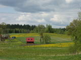 |
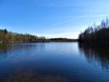
Samērā liela teritorija ar mozaīkveida ainavu - mežiem, atklātām ainavām un ezeriem (Salmejs, Kaučers, Stupānu ezers, Limanu ezers u.c.), kas atrodas Latgales augstienes Feimaņu pauguraines rietumdaļā. Aizsargājamo ainavu apvidus veidots šejienes dabas un kultūrainavas (apdzīvotās vietas, Tišas vecticībnieku lūgšanas nams, krucifiksi) un daudzveidīgo biotopu (t.sk. - sugu) aizsardzībai. Apvidū atrodas arī samērā populārs tūrisma objekts - Šnepstu pilskalns.
|
|
 |
Das ist ein langgestrecktes Gebiet zwischen der Ostsee und der Straße Kolka – Ventpils. Es beginnt an der Mündung des Flusses Irbe und endet in Ovīšrags. Das Territorium wurde vor allem eingerichtet, um den trockenen Koniferenwald, die Graudünen, Feuchtbegiete zwischen den Dünen, andere Landschaftserscheinungen, Pflanzen und Tiere in dem Gebiet zu schützen. Touristen lieben die sandigen und ruhigen Strände in dieser Gegend, die Leuchttürme von Miķeļbāka und Ovīši und die lutherische Kirche in Miķeļbāka. Hier gibt es auch noch einige Hinterlassenschaften des sowjetischen Militärsystems, die nicht touristisch genutzt werden.
|
|
 |
This arboretum is in a lovely location in the Vidzeme highlands. It covers 140 hectares of land and offers a look at interesting coniferous trees, lianas, lilacs, rhododendrons and peonies. The facility has a modern visitor information centres.
Unique species: The Tulip Tree (Liriodendron tulipifera), the Fringe Tree (Chionanthus virginicus), and the Kobushi Magnolia (Magnolia kobus).
|
|
 |
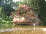
Einen malerische Sandsteinfelsen bis 600 m lang und 21 m hoch am linken Flussufer vom Gauja. |
|
 |
Beautiful views are accessible from the Sabile castle hill (steps, a location for relaxation), Upurkalns Hill (no improvements) and Briņķpedvāle, which part of the Pedvāle Open-Air Art Museum. There are also the Drubaži nature trails. The road between Kandava and Sabile which runs along the right bank of the Abava and the Aizdzire-Kalnmuiža road which runs on the left bank of the Abava also offer beautiful landscapes.
|
|
|
|
No 28 m augstā torņa, kas atrodas uz apdzīvotas „salas” – Siksalas Teiču purva vidū, paveras ļoti plaša augstā purva ainava ar Siksalas ezeru, citām minerālzemes salām un Siksalas mazciemu. Tā kā tornis atrodas Teiču dabas rezervātā, to var apmeklēt tikai Dabas aizsardzības pārvaldes inspektora pavadībā, iepriekš piesakot vizīti T: + 371 28333415. |
|
 |
Die Grüne Düne – Nach den Krāču Hügeln ist dies
die zweite ausgeprägteste Dünenbildung im Nationalpark
Ķemeri, die in mehr als drei Kilometer länge das
Hexenmoor von dem Grünen Moor trennt. Am Fuß der
Düne windet sich ein alter Erdweg, auf dem die Strecke
verläuft. Während Sie entlang der Grünen Düne
wandert, benutzen Sie bitte nur vorhandene Pfade!
|
|
|
|
This trail offers education about the forest for children of all ages, families with children, and friends of the environment. The trail is located in the Īle Parish of the Auce Administrative District, 2 km from the Pokaiņu forest. |
|
 |
These are beautiful and impressive views, particularly early in the morning, of the historical locations of Alūksne. Go to Templis Hill, the Aleksandrs Pavilion, the obelisk which commemorates Heinrich von Fittinghoff, and the memorial to soldiers of the No. 7 Sigulda Brigade for good views. The Templis Hill, the castle ruins, the estate and the pavilions are arhitectural monuments.
|
|
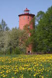 |
Der zweitälteste Navigationsbau in Lettland, und der einzige, der sich 5 km vom Meeresufer entfernt an der obersten Seite des Baltischen Eissees befindet. Seit 2000 wird die Funktion des Leuchtturms hier nicht mehr erfüllt, stattdessen ist hier nun das Naturbildungszentrum „Slītere“ des Nationalparks Slītere untergebracht. Hier kann man Ausstellungen über lettische Leuchttürme und die Geschichte der Ostsee sehen. Aus dem obersten Geschoss (102 m über dem Meeresspiegel) kann man die Küste der Insel Saaremaa (ca. 33 km entfernt) sehen. Neben dem Leuchtturm verläuft der 1,2 km lange Slītere Naturpfad. |
|
 |
Between Saunags and Vaide on the road to Kolka, you will see an area on the left (South) side of the road where there was a massive forest fire in 1992 which burned approximately 3,300 hectares of forest. Biologists use the area to study the regeneration of the forest. There were extensive and destructive fires here during the early 20th century, as well. Swedish scientists say that there have been at least 15 fires in the forests of Šlītere over the last several centuries. The burned area is in a nature reserve and can only be viewed from the road. |
|
 |
This is one of the most beautiful and popular tourism locations in Vidzeme. The cliff is 45 metres high, and the height of the lovely open-faced portion is around 20 metres high. You can look at the wide and deep Amata River valley and its forested banks.
|
|
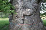 |
Сохранилась лишь небольшая часть мощных ветвей, самые толстые из которых поддерживаются подставками, а пустую середину от дождя и снега защищает козырек. Самый толстый черешчатый дуб (Quercus robur) в Латвии и во всей Балтии, и самое толстое дерево Балтии. Один из самых толстых дубов Северной Европы. Живописен. Невдалеке от дуба находится стоянка для автомобилей и информационный стенд. |
|
 |
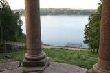
These two lakes, along with Lake Mazezers, Lake Auziņš, Lake Skuja and Lake Bruņķītis, are found in a sub-glacial depression with shores and hillsides that are home to various kinds of forest, including stands of broadband trees such as ash. These are protected habitats. Alongside the Priedītes homestead there is a well-appointed nature trail for visitors who wish to study Lake Dziļezers and its surroundings. A boating facility is on the north-eastern shore of the Lake.
|
|
 |
Благоустроенная природная тропа знакомит с одним из редких обрывов Рижского морского залива (высотой до 15 м) и лесами побережья. По лестнице можно спуститься к необыкновенно узкой полоске песчаного пляжа, который во время шторма исчезает в морских волнах. Протяженность тропы - 0,3 км в одном направлении. На обочине шоссе Колка – Юрмала обустроена автостоянка (находится у границы Слитерского национального парка). |
|
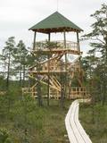 |
This is part of a hiking trail along the Cena bog. It is on the western side of the bog, at the centre of the 5-kilometre circular trail. You can see the vast swamp, as well as a military road that was installed during World War I and is marked by an “alley” of large pine trees. Alongside the tower is a fragment of the road that was installed more recently.
|
|
 |
Гора Мицану-Киркас. Маленький замок в Приежукалне в
1792 году был преобразован в лютеранскую церковь. До сих пор
гору называют „Кирха” (нем. Kirche – церковь). Пожилые люди
говорят, что под церковью был построен большой подвал, в котором хранились драгоценности семьи
Мантейфелей и церкви, в подвале находится семейный склеп Мантейфелей.
|
|
 |
Another area where the manifestations water-soluble lime in the earth can be found. As the lime dissolves, there are empty areas underground which eventually collapse. To the East of Skaistkalne is a leisure area where dry and full holes of various sizes can be found.
|
|
 |
One of the few places in Latvia where there are so many well-organised pathways. The region is known for castle hills, the location where the great Latvian author Anna Brigadere (1861-1933) lived and worked, the storybook character figures that are scattered around that area, a great forest, an arboretum, a museum of history, a viewing tower, landscapes, etc. This has been recognised as the most family-friendly place in the country.
|
|
 |
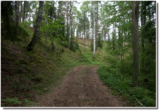
Neskartu mežu cienītāji var doties izpētīt Plakanciema puses mežu takas. Braucot no Plakanciema pasta nodaļas Mellupu virzienā pa autoceļu V7, pēc aptuveni 1 km jānogriežas ceļā pa labi. Tālāk jādodas uz priekšu vēl 1,2 km. Maršruta sākums - iepretī mājām “Putriņas” ceļa kreisajā pusē, kur sākas meža ceļš. Sākumā maršruts ved pa taisnu meža ceļu. Pēc 500 m nonākam pie ūdenskrātuves (karjera). Šeit ir iespēja doties vai nu gar vienu ūdenskrātuves krastu, vai gar otru. Abās pusēs var aiziet aptuveni līdz ūdenskrātuves pusei un tad griezties atpakaļ. Krastā augošos kokus iecienījuši bebri. Ūdenī peldas pīles, meža ceļa malā vairāki skudrupūžņi, no sakritušo pērno lapu apakšas lien ārā zaķskābenes. |
|


