
| Нo | Название | Описание |
|---|---|---|
 |
Jaanihanso Cider House makes cider from natural Estonian apples. Here there is a special technique applied to making the cider – the cider clears and matures as same as the best champagne in the world does. Here it’s possible to try different ciders and for additional fee, snacks to with it, as well as take a tour around the Cider House. In this case, registering one week in advance is necessary. |
|
 |
В хозяйстве, расположенном на излучине правого берега Венты, выращивают коз и производят сыр. Для посетителей – возможность продегустировать сыр и приобрести продукцию. Принимают заказы. |
|
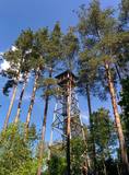 |
Uzcelts apkaimes augstākajā vietā – Ančupānu meža kalnā, kuru vietējie dēvē par „Bāku”. No 26 m augstā torņa redzama ļoti plaša panorāma ar Rēzeknes pilsētas namiem, baznīcu torņiem un apkaimes mežu masīviem, kas mijas ar lauksaimniecībā izmantojamām zemēm. Blakus tornim – atpūtas vieta. |
|
 |
Nature restricted area includes eastern side of the lake with Lanupe River and North-east and South-east coastal areas. Restricted area has been established for protection of birds and floodplain meadows of the lake. To see the nature restricted area visitors do not have to enter it. There are great view points with wind generators of Grobina on the background from the road Vecpils – Rava – Aistere. Coastal areas which are not included in the restricted area are perfectly suitable for bird watching. There is located the smallest city by its population in Latvia to the South from the lake.
|
|
 |
"Piebalga medus" is located in Vecpiebalga region, turning off the highway Cēsis – Vecpiebalga – Madona (P30). Beekeeping, apitherapy and narration "About and around bees". Tasting and purchase of beekeeping products. A candlestick workshop is available for visitors. Especially with the fact that the apiary only with Latvian hives. |
|
 |
Находится на обочине Видземского шоссе (A2). Размещен в красивом срубе с соломенной кровлей и старинным интерьером. В приготовлении блюд объединяют старинные традиции с требованиями современных клиентов. Латышская кухня: Холодный и суп с фрикадельками, серый горох с салом, ячменная каша, миноги в горчичном соусе, жареный на углях судак, жареное свиное ухо, жаркое из свиной голени, куриная печень в сметанном соусе, слойка из черного хлеба, творожный десерт с клюквенным соусом. |
|
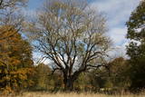 |
This is the thickest European Ash (Fraxius excelsior) in Latvia and the Baltic States. The homestead where the tree is found is the memorial museum of the painter Ģederts Eliass, and for that reason, the tree is sometimes also known as the Eliass ash tree.
|
|
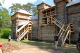 |
Обширнейшая в Балтии экспозиция, знакомящая с материальной культурой земгалов в эпоху железного века. Богатое собрание земгальских украшений, оружия и предметов быта, крупнейшая в Балтии коллекция мечей. Экспозиция размещена в помещениях отреставрированного защитного строения Терветского деревянного замка XII века. Ежегодно в выходные второй недели августа здесь проводится Международный праздник земгалов - крупнейший фестиваль Балтии, посвященный этапу раннего средневековья. |
|
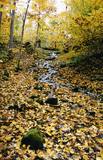 |
The lime gully that emerged as the Baltic ice lake receded is crossed by the powerful streams of Mežmuiža, and the water from these streams contains a high concentration of lime salts. The water from the streams flows into a mill pond that has a very interesting colour. The sculptor Teodors Zaļkalns once lived in the travertine mill that is alongside the pond. Wood pathways have been installed for those who wish to visit the streams.
|
|
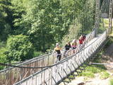 |
The Gauja National Park, established in 1973, was Latvia’s first national park, and it has a wealth of tradition in environmental protection and tourism. Indeed, the GNP is one of the most popular tourist destinations in Latvia. The main “artery” of the park is the ancient Gauja River valley, which was left behind when Ice Age glaciers receded. The valley is 95 kilometres long, with many tributaries that are also in deep ravines with massive sandstone cliffs from the Devonian period. The deepest part of the river valley is at Sigulda, where it is 85 metres deep. The territory has a great diversity of species – some 900 plant species in all. The Gauja is Latvia’s most popular river for water tourism, and many tourist accommodations are found along its shores. The Gauja National Park is one of the best-appointed protected territories in Latvia in terms of nature trails and tourism routes. Nature trails at Līgatne pass along paddocks of wild animals – the largest and most complete object of its kind in the Baltic States. The park also features cultural monuments of pan-Baltic importance – the Turaida Museum Reserve, the medieval old town of the city of Cēsis with its famous castle ruins and St John’s Church, the lake castle at Āraiši, etc. Visitors centres are found in Sigulda, along the Līgatne nature trails, and at the Zvārte rock. The administration of the GNP is building a new and modern visitors centre in Sigulda.
|
|
 |
В небольшом населенном пункте, где сегодня расположена только одна гостиница, – в Олмани находились две важные береговые батареи. Их объединяло название Краснофлотская. До 1955 года в той, которая базировалась на юге от Олмани, размещались четыре 152-мм артсистемы типа «Канэ», которые изготавливались во время Первой мировой войны и широко применялись СССР для защиты территорий побережья Балтийского моря в Эстонии и Латвии. Сегодня в этих местах сохранились небольшие концентрические земляные валы. После 1955 года к северу от Олмани базируется новая батарея - четыре 152-мм артсистемы типа МУ-2. Они способны вести стрельбу на расстоянии 25 км. Во время строительства это была самая современная из всех береговых батарей того времени; обустройство батареи началось в 1952 году. Батарея находилась в боевой готовности и действовала до 1975 года, затем была законсервирована и держалась в резерве. Незнающему трудно будет найти месторасположение этой батареи, но находка стоит того. Сохранились бетонные платформы для установки и подземные бункеры. Действительно, одна из впечатляющих батарей побережья Балтийского моря!
|
|
 |
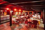
Семейный ресторан у Меллужской эстрады – в Юрмале, в 27 км от Риги. Предложение европейской и латышской кухни на все приемы пищи: супы дня, салаты, основные блюда, выбор десертов и уютная атмосфера. |
|
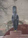 |
Opposite the tower of the Church of the Holy Trinity, the monument was designed by Arta Dumpe and commemorates Latvia’s first president, Jānis Čakste (1859-1927). It was consecrated on November 14, 2003, precisely 81 years after the statesman was elected to the important position. |
|
 |
An afforested island in the Gulf of Finland, approximately 14 km to the North of Tallinn. There is a network of small roads and trails on the island. Forests: Mostly 1.1, 1.2 and 4.2. Information: www.aegna.ee. A ferry boat to the island departs from the port at Pirita. Hike around the shore of the island, where you will find all kinds of environments – dunes, sandy areas, rocky areas and places with lots of reeds (~9 km). |
|
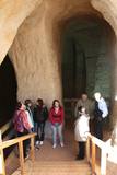 |
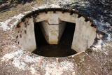
The area of the ancient Piusa River valley that is between the villages of Vana-Vastseliina and Ignasõ is around 15 km long, features some substantial rapids, and offers a view of beautiful Devonian period cliffs. The largest, Härma müür, is 43 metres high and is the highest sandstone cliff in Estonia. There are caves from old mines in the village of Piusa. A small part of the mines, which have tunnels that are more than 10 km long in all, has been tured into a local museum.
|
|
 |
Baltijas mērogā unikāls dabas un cilvēkizmantots apvidus, kas veidojies kādreiz - padomju, mūsdienās - Latvijas Nacionālo bruņoto spēku pārvaldītā armijas poligona teritorijā. Poligona lielāko daļu aizņem smilšains vai ar zemiem lakstaugiem un krūmāju apaudzis kāpu masīvs ar atsevišķiem lielākiem kāpu vaļņiem. Rudens laikā šeit lielās platībās zied virši. Unikālā virsāju un aprimušo kāpu ainava un daudzu sugu dzīves vieta bija daži no iemesliem, kādēļ šai militārai teritorijai ir piešķirts arī aizsargājamas dabas teritorijas statuss. Jāatgādina, ka poligona apmeklējumi privātpersonām bez iepriekšēja saskaņojuma ir aizliegti!
|
|
 |
Talsu vecpilsētā, pašā vēsturiskā centra vidū, atrodas īpaša vieta, kur saplūst lauku miers un pilsētas dzīvīgums. Te vari izbaudīt gan klusumu un nesteidzīgu atmosfēru, gan arī sajust tuvumā esošo ielu dzīves ritmu. Šī māja ir kā radīta romantiskam nedēļas nogales atpūtam divatā — vakarā iekurt kamīnu, iemirdzināt telpu sveču gaismā un baudīt siltu vīna glāzi klusā divvientulībā. Tajā pašā laikā tā lieliski piemērota arī ģimenēm vai draugu kompānijām, kas vēlas pavadīt laiku kopā ērtā un plašā vidē. Villā pieejamas piecas guļamistabas, divas vannas istabas, kvalitatīva gultas veļa un dvieļi, satelīttelevīzija plakanajā ekrānā, ērta ēdamzona, pilnībā aprīkota virtuve, kā arī terase ar skatu uz dārzu. Papildus ērtībām viesiem ir atpūtas zona un kamīns, kas lieliski papildina vietas mājīgumu. |
|
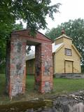 |
The building was built in 1800 and rebuilt in 1825. Zosna Catholic Church is one of the smallest wooden churches in Latgale and the oldest church of the Rāzna National Park. The building is famous for the altarpiece "Madonna with a child". Noteworthy is also the gate, fence (built from red bricks and boulders) and the bell tower. Not far from the church there lives a manager with whom you can agree on seeing the church from the inside. |
|
 |
Работы ремесленника характеризуются лаконичными формами, сдержанными украшениями и они подходят для практических обыденных потребностей. Экскурсия по мастерской, осмотр печи, демонстрации и возможность поработать с глиной самим. Приобретение готовых работ, осмотр пчелиной пасеки, дегустация и покупка меда. |
|
 |
В хозяйстве выращивают овец, кроликов, лошадей, африканских страусов и других домашних птиц, а также грибы шиитаки. Здесь можно заказать и приобрести грибы, сувениры из страусиного пера и другую сельскохозяйственную продукцию. |
|


