
Природные объекты в Эстонии

Что особенного в природе в Эстонии?
В Эстонии стоит самая впечатляющая каменная стена в Балтии - так называемый северо-эстонский «глинт» (от эстонского языка). У Эстонии есть своя «Земля островов» - регион Лахемаа с национальным парком, «Земля островов» - остров Сааремаа и архипелаг Монцунд. Залив Матсалу является одной из наиболее значительных остановок для отдыха птиц во время их миграции. В Эстонии есть один из самых заметных ударных кратеров в Европе, самые большие водопады и валуны в Балтии, холм Мунамаги - самая высокая точка в Балтии, Чудское озеро - 5-е по величине озеро в Европе, - с длинной Постоянные рыболовные традиции и великое разнообразие природы с запада на восток, с севера на юг.
Действуй ответственно - следуй Зеленому совету!
| Обзор | Подробности |
|---|---|
 |
Эстония
The Endla ReserveThis reserve was set up to protect local swamps and surrounding wetlands. Please note that before you can visit the reserve, you must register with the local administration and visitor centre in the village of Tooma.
УслугиСервисы - отдых
Природная тропаThe Endla swamp trail (~2 km) with a viewing tower, and the Endla stream trail (6 km). Please note that before you can visit the reserve, you must register with the local administration and visitor centre in the village of Tooma. For more information: www.endlakaitseala.ee (available in English). |
 |
Эстония
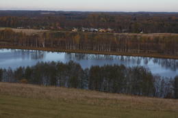
The Vooremaa field of drumlinsThis is the most visually impressive drumlin field in the Baltic States, and it is close to the village of Tabivere. The drumlins were established by ice glaciers, and they point in the direction in which the ice moved long ago. In terms of their appearance, the drumlins resemble loaf-shaped hillocks. From their “backs,” there are lovely views of the local landscape and the lakes that are around the area. The visitor centre is in the village of Äksi.
|
 |
Эстония
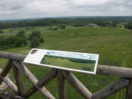
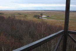
Torna kalns (Tornimägi)Karulas augstienes augstākais reljefa punkts (137 m.vjl.), kas virs tuvākās apkārtnes paceļas par ~ 60 m. Torņa kalnā ir uzbūvēts skatu tornis ar ļoti plašu apkārtskatu. Uz tā platformas ir novietoti panorāmas fotoattēli, kuros atzīmēti zīmīgākie plašākā apkaimē redzamie objekti – apdzīvotas vietas, pilskalni, baznīcu torņi u.c. Turpat izveidota atpūtas vieta un meklējams Rebases ainavu takas sākums.  260 260
Услуги
260km - Расстояние от столицы |
 |
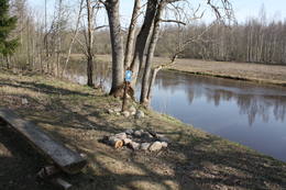
Эстония
Joaveski udenskritumi (Joaveski joastik)Krāčains Lobu upes (Loobu jõgi) posms pie Joaveski ciema, kur ~ 160 m garumā upes gultnē, tai šķērsojot Ziemeļigaunijas glintu, izveidojušās izmēros nelielas, tomēr ļoti ainaviskas un skaistas 0,5 – 1 m augstas ūdenskritumu kaskādes. 1898. g. šeit uzcēla hidroelektrostaciju, kuras atliekas ir redzamas upes labajā krastā. Iecienīta pavasara laivotāju treniņu vieta. |
 |
Эстония
Suitsu tornis (Suitsu torn)Suitsu tornis celts 1979. g. kā pirmais Matsalu rezervāta metāla tornis. To atjaunoja 1998. g. Torņa augstums ir 21 m, tādēļ no tā paveras izcila dabas un kultūrainava uz Kazari deltas niedrājiem un blakus esošo Suitsu upi (Suitsu jõgi), kuras krastā ir uzceltas vairākas zvejnieku laivu būdas. |
 |
Эстония
Kap TahkunaDer weiteste Nordpunkt der Insel Hiiumaa. Der höchste Leuchtturm Estlands aus Roheisen (1873 – 1875) und das Denkmal zur Errinerung an die bei dem Unglück des Schiffes ‘Estonia” Umgekommenen. 175
Услуги
175km - Расстояние от столицы |
 |
Эстония
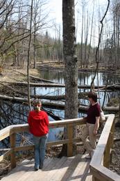
Bebru taka (Koprarada)Divus kilometrus garās lokveida takas sākums ir meklējams pie Somā nacionālā parka apmeklētāju centra (atklāts 2000. gadā) – Tēramā ciemā. Tā ved gar Mardu strauta (Mardu oja) krastu, kur krustām šķērsām ir sakrituši bebru nogāztie koki, radot diezgan juceklīgu skatu. Apmeklētāju centrā var iegūt nepieciešamo informāciju, noskatīties videofilmu un nacionālajam parkam veltītu ekspozīciju. 171
Услуги
171km - Расстояние от столицы |
 |
Эстония
Туристическая фирма Heritage ToursПредприятие организует природные походы, целью которых является знакомство с природой (наблюдение за тюленями, пешие, велосипедные и лыжные природные походы, на резиновых лодках по островкам национального парка Вилсанди, вылазки к орхидеям и т. д.) и культурным наследием (мыза, сельская и городская жизнь, сегодняшний день Эстонского ремесла, морское наследие). В находящемся на территории национального парка Вилсанди лесном парке Мику можно познакомиться со старинными работами в лесу и даже поучаствовать в них. 200
 1-12 1-12
Услуги
200km - Расстояние от столицы
1-12 Месяцы активного сезона |
 |
Эстония
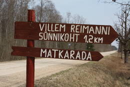
Paunas taka (Pauna rada)Kultūrvēsturiska taka (garums ~ 2 km) Tipu (Tipu) ciemā, kas iepazīstina ar vairākiem interesantiem objektiem: veco skolu (1931. g.), Hallistes upi, pirti un Paunas saimniecību, kurā dzimis viens no Igaunijas nacionālās kustības līderiem Villems Reimans (1861. – 1917.). |
 |
Эстония
НайссаарНайссаар- маленький эстонский остров, которым с конца II Мировой войны до 1993-го года владели советские вооруженные силы. Достопримечательностями острова являются прогулочные тропы, богатая видами природа, узкоколейная железная дорога, артиллерийская батарея царских времен и завод морских мин советского времени. 12
1-12
Услуги
12km - Расстояние от столицы
1-12 Месяцы активного сезона |
 |
Эстония
Perajerva meza taka (Pärajärve metsarada)Četrus kilometrus gara marķēta lokveida taka, kas ved pa lielāku meža masīvu, iepazīstina ne tikai ar augiem un dzīvniekiem, bet arī mežsaimniecības tradīcijām. Takas sākums atrodas pie nelielā Perejerves ciema, uz kuru paveras labs skats no tuvējā paugura. Pie autostāvlaukuma izveidota atpūtas un piknika vieta. |
 |
Эстония
Halbinsel PärispeaAuf der Küste der Halbinsel befinden sich sowohl ehemalige Fischerdörfer, als auch die Reste eines Militärstützpunkts der Sowjetarmee. Großartige von den Gletschern des Eiszeitalters eingebrachte Feldsteine. 74
Услуги
74km - Расстояние от столицы |
 |
Эстония
Harilaidas pussala (Harilaid)Sāmsalas ziemeļrietumu daļā jūrā iestiepjas iespaidīgā Tagameizas pussala (Tagamõisa poolsaar). Tās ziemeļrietumu daļā meklējama mazāka – ap 5 km garā Harilaidas pussala (Harilaid). Pussalas vidusdaļā viļņojas Lajalepas ezers (Laialepa järv) - bijušais jūras līcis, kas zemes garozai ceļoties, kļuvis par iekšēju ūdenstilpi. Arī pati Harilaida (igauniski „laid” nozīmē „saliņa”) vairāk nekā trīs gadsimtus atpakaļ bijusi sala. Harilaidu iecienījuši ne tikai migrējošie putni, bet arī roņi, kurus piesaista vientuļi līči un akmeņainās sēres. Harilaidu var apmeklēt tikai ar kājām vai ar divriteni, bet spēkrati ir jāatstāj autostāvlaukumā. No tā ~ 1 km attālumā atrodas vieta, kur pēc 17. gs. radies Harilaidas savienojums ar Sāmsalu. Šeit paveras nepierasti klaja un akmeņaina ainava. Pārējā Harilaidas daļa ir apmežota pirms ~ 40 gadiem. Kopumā būs jāveic ~ 10 km garš pārgājiens. 273
Услуги
273km - Расстояние от столицы |
 |
Эстония
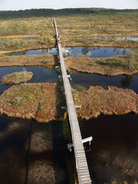
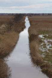
Penije tornis (Penijõe torn)Lai nokļūtu līdz šim tornim, ir jāveic apmēram 20 – 30 min ilgs pārgājiens pa dabas taku no Penijē muižas gar Penijegi (Penijõgi) kreiso krastu. Te redzami bebru darbi un to celtās zaru mājas. No torņa paveras skats uz Kazari deltu, kas dabā izpaužas kā monolīts un nepārskatāms niedrājs. To vairākās daļās sadala Kazari un mazāka izmēra upītes. Katrai deltas daļai ir savs vēsturiskais nosaukums: no torņa pa kreisi no Penijegi redzama Lihula meri (Lihulas „jūra”), bet tās labajā pusē - Kloostri meri (Klostri „jūra”). Putnu vērotāji var iziet garāku (7 km) dabas takas loku, kas ved pa palieņu pļavām. Jārēķinās, ka pavasaros būs nepieciešami piemēroti apavi! Pļavas ierobežotās platībās apsaimnieko mājdzīvnieki, tādēļ neaizmirstiet aizvērt vārtiņus aiz sevis un netraucējiet to ikdienas gaitas! No maršruta nav atļauts novirzīties, lai netraucētu putnus. |
 |
Эстония
Ландшафтный заказник Тухала и Ведьмин колодецМестность Тухала была заселена почти 3000 лет назад. Здесь 11 древних поселений, 30 культовых камней, 3 каменных могильника, 4 культовые рощи и т. д. В ландшафтном заказнике Тухала располагается и уникальный Ведьмин колодец, который во время большой воды «кипит», выливая 100 литров воды в секунду, а также 5 мощнейших энергетических столбов в Эстонии. 32
1-12
Услуги
32km - Расстояние от столицы
1-12 Месяцы активного сезона |
 |
Эстония
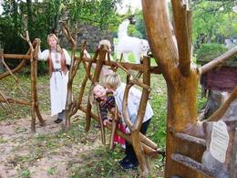
Viking villageA unique theme park on the River Pirita evokes interest in ancient Vikings. Facilities include: stronghold, chamber of spells, smithy, Viking boat and dugout canoe trips, shows and battles with ancient weapons, a catapult, archery, axe throwing, cave and smoke saunas, trout fishing, accommodation, catering etc.  30
1-12
30
1-12
Услуги
30km - Расстояние от столицы
1-12 Месяцы активного сезона |
 |
Эстония
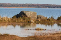
Neri akmeni (Näärikivid)Trīs lielāka izmēra laukakmeņi – aizsargājami dabas pieminekļi, kas atrodas Matsalu līča krastā starp Sāstnas (Saastna) un Metskjulas (Metsküla) ciemiem. Tuvējā ceļa malā ir izvietots informācijas stends un norādes, bet līdz akmeņiem var nokļūt pa iezīmētu taku. Pēc kāda tautas nostāsta, lielas vētras laikā, kas notikusi Jaungada naktī, lielais akmens sašķēlies trīs daļās. No tā arī cēlies vietvārds. Apkārtnē redzamās pļavas ir nozīmīga daudzu augu sugu dzīves vide un svarīga putnu ligzdošanas un atpūtas vieta. Šī iemesla dēļ taku drīkst apmeklēt tikai no 1. jūlija līdz septembra beigām. Akmeņi ir arī labi redzami no minētā ceļa. Tie ar ledāju atceļojuši no Turku (Somija) apkārtnes. 129
Услуги
129km - Расстояние от столицы |
 |
Эстония
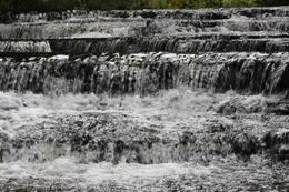
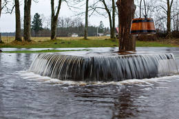
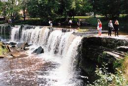
Keila waterfallThis is one of the loveliest waterfalls in Estonia – up to 6 m in height and 50 m in width. Recommended: The rapid Keila River has carved a cliffy canyon behind the waterfall, with a flow of water that falls down a major distance. It’s worth hiking through the Keila park to the shore of the Bay of Finland (~1 km), then returning along the other bank of the river.
Услуги
31km - Расстояние от столицыСервисы - отдых
Природная тропаThe rapid Keila River has carved a cliffy canyon behind the waterfall, with a flow of water that falls down a major distance. It’s worth hiking through the Keila park to the shore of the Bay of Finland (~1 km), then returning along the other bank of the river. |
 |
Эстония
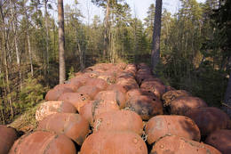
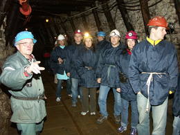
Gas mixtureGas mixture is the main raw material for Estonia’s energy and chemical industries, and it is extracted in our day from open quarries or underground shafts. This layer was established during the Ordovician Period between 450 and 480 million years ago, and it is made up of the remnants of plants and animals from that age. In the Kohtla-Nõmme suburb, there is a shaft which can be toured in the company of a guide who will tell you that this is the only layer of its kind in the Baltic States. He will tell you about how the gas mixture has been extracted over the course of history.
УслугиСервисы - отдых
Наблюдение за природойIn the village of Kiviõli, in turn, you can climb an old hill of slag from the gas mixture (Vana tuhamägi). This will open up a view of one of Estonia’s most interesting landscapes. For more information: www.kivioli.ee (available in English). |
 |
Эстония
Hjupasares pargajienu taka (Hüpassaare matkarada)Iepazīstina ar Somā nacionālā parka lielākā purva – Kureso (Kuresoo) ziemeļaustrumu daļu, kur redzamas purva ezeriņu un lāmu ainavas. Takas sākumā atrodas igauņu komponista, ērģelnieka un folkloras vācēja Marta Sāra (Mart Saar) (1882. – 1963.) dzimtās mājas. To apkaimē pļavas apsaimnieko aitas. Lokveida takas garums ir 4,2 km. 169
Услуги
169km - Расстояние от столицы |
|
|
Эстония
Klostri (Kloostri) skatu tornisMetāla tornis Kazari upes kreisajā krastā, ~ 5 km attālumā no Matsalu līča. No torņa redzamās Kazari deltas palieņu pļavas atrodas tikai 0,3 – 1 m augstumā virs jūras līmeņa, tādēļ pavasara palos un stipru vētru (īpaši rietumvēju) laikā ūdens appludina milzīgu teritoriju. Uzskata, ka platības ziņā šīs ir vienas no lielākajām Eiropas palieņu pļavām, kas ir nozīmīga dažādu tārtiņveidīgo putnu sugu ligzdošanas, dzērvju un zosveidīgo putnu atpūtas un barošanās vieta. Ir pagājis laiks, kad zemnieki Matsalu pļavās ganīja govis un pļāva sienu, tādēļ šobrīd pļavu apsaimniekošanu veic nacionālā parka administrācija. |
 |
Эстония
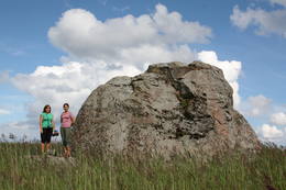
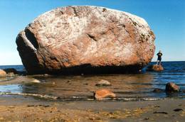
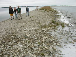
The Letipea Ehalkivi rockThis is the largest rock in the Baltic States and, according to some sources, in all of the segment of Northern Europe which was affected by the last Ice Age. Its size is 930 m3! The rock is 7.5 m high, 16.5 m long and 14 m high, with a circumference of 48.5 m. The rock resembles a huge pebble from a distance, and it is on the sandy and rocky beach. Depending on the season, it can be out in the water. The Ice Age carried the rock to its current location from the southern shore of Finland. It is made of pegmatite.
|
 |
Эстония
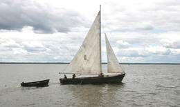
Прогулки на парусной лодкеВ качестве судна на Выртсъярв традиционно применялся деревянный траловый парусник, который благодаря его грациозному внешнему виду часто использовался и для увеселительных поездок. Обладающий статным корпусом парусник имеет два треугольных паруса. В 2005 году при поддержке целевого фонда Выртсъярв была изготовлена лодка "Паула", и в 2009 году - лодка "Лийзу". Катаясь на парусной лодке, Вы получите незабываемые впечатления. 181
5-9
Услуги
181km - Расстояние от столицы
5-9 Месяцы активного сезона |
|
|
Эстония
Anhöhe OtepääOne of the three highlands of Southern Estonia with scenic hills and beautiful sights. In its center lies the bay-rich Lake Pühajärv (translating from Estonian - Holy Lake). 230
Услуги
230km - Расстояние от столицы |
 |
Эстония
Mejekoses pargajienu taka (Meiekose matkarada)~ 3 – 5 km gara taka, kas ved pa veco ceļu gar Tēramā upes (Tõramaa jõgi) kreiso krastu. Takas malās izvietoti interaktīvi elementi bērniem, kas palīdz labāk uztvert dabā notiekošo. Taku ieskauj mitrie meži un palieņu pļavas, kas palu laikā atrodas zem ūdens. Tēramā (Tõramaa) ciemā apkārtnē atrastas cilvēka darbības pēdas jau no akmens laikmeta. 149
Услуги
149km - Расстояние от столицы |
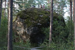 |
Эстония
Stein MajakiviDer dritgrößte Feldstein im Baltikum (584 m3, 7 m hoch, Durchmesser bei dem Grund – 32 m ). Auf estnisch bedeutet „Hausstein”. Befindet sich am Rande des Pikanõmme – Majakivi Pfades (4,5 km lang). 60
Услуги
60km - Расстояние от столицы |
 |
Эстония
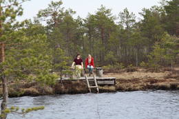
Erdi taka (Öördi rada)1,2 km gara taka, kas pa purvainu mežu aizved līdz Ērdi purvam (Öördi raba) un tā austrumu daļā esošajam Ērdi ezeram (Öördi järv), pie kura izveidota atpūtas un peldvieta. |
 |
Эстония
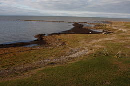
Putnu verosanas tornis Puises ragaPuises ragā (Puise nina) ir uzcelts divstāvīgs atpūtas nams, kas apvienots ar putnu vērošanas torni. No tā paveras skats uz piekrasti, kas ir iecienīta migrējošo zosu atpūtas vieta. Šī ir privāta teritorija, kuras apskati vēlams saskaņot ar īpašnieku. 123
Услуги
123km - Расстояние от столицы |
 |
Эстония
KassariThe Kassari Island is the fifth largest Estonian island, and it is found to the South of the Hiiumaa Island. There are two dams between the two islands, and a road for motor vehicles has been installed atop them.
Услуги
150km - Расстояние от столицыСервисы - отдых
ВеломаршрутBike the route Käina-Orjaku-Kassari-Esiküla-Käina (22 km).
Природная тропаThe Orjaku nature trail (up to 2 km); the Sääre tirp – a 3-km hike along a rocky path on the southern end of the Kassari Island;
Наблюдение за природойBirdwatchers will enjoy the Bay of Käina, where a colony of great cormorants and other water birds can be found. There is a bird-watching tower at Orjaku, as well as a viewing platform at the Bay of Vemla (Vaemla laht). |
 |
Эстония
Семейный парк ЛесовницыСемейный парк Лесовницы - расположенное между холмами Кайка объединение хуторов, которое предлагает различные возможности для ознакомления с близким к природе здоровым образом жизни и народной медициной. В рамках предлагаемых хуторами программ можно познакомиться с траволечением, гирудотерапией, волшебным миром пчел и грибов, а также ощутить на себе влияние заклинаний и мест для медитации. Также можно научиться готовить блюда из сорняков, домашний хлеб и лекарство из трав. Одиночные посетители могут самостоятельно познакомиться с хутором. 275
5-9
Услуги
275km - Расстояние от столицы
5-9 Месяцы активного сезона |


