
Dabas objekti Igaunijā

Ar ko ievērojama daba Igaunijā?
Iespaidīgākā Baltijas klinšu siena – t.s. Ziemeļigaunijas glints, „Līču zeme” – Lahemā ar nacionālo parku, „Salu zeme” – Sāremā sala un Monzunda salu arhipelāgs, Matsalu līcis kā viena no nozīmīgākajām masveida putnu atpūtas vietām migrāciju laikā, viens no izcilākajiem Eiropas meteorīta krāteriem, izcilākie Baltijas dižakmeņi un ūdenskritumi, Munameģis – Baltijas augstākā virsotne, Peipuss – piektais lielākais Eiropas ezers – ar senām zivju ieguves tradīcijām un ārkārtīgi lielā dabas daudzveidība, kas ir acīmredzami mainīga gan austrumu – rietumu, gan ziemeļu – dienvidu virzienā, ir tikai dažas no Igaunijas valsts dabas pievilcībām.
Lai uzzinātu vairāk par apmeklējamām teritorijām aicinām izmantot vides vai vietējo gidu pakalpojumus. Esiet saudzīgi pret dabu ceļojuma laikā - ievērojiet Zaļos padomus!
| Pārskats | Detaļas |
|---|---|
 |
Igaunija
NaisāreMežiem klāta sala (6. lielākā Igaunijas sala) Somu līcī 14 km Z no Tallinas. Vēl pirms divām desmitgadēm – slēgtā zona, jo Padomju laikā te atradās ļoti slepena jūras mīnu ražotne.
|
 |
Igaunija
Tahkuna ragsTālākais Hiiumaa salas ziemeļu punkts. Igaunijas augstākā čuguna bāka (1873. – 1875. g.) un piemineklis kuģa „Estonia” bojā gājušo piemiņai.  175 175
Pakalpojumi
175km - Attālums no valsts galvaspilsētas |
 |
Igaunija
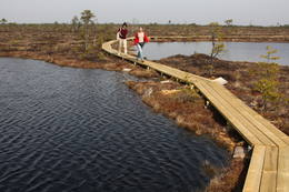
Kostiveres karsta lauksIgaunijas vizuāli izteiksmīgākais karsta lauks 125 ha platībā ar dažādām karsta procesu izpausmēm – pazemes strautiem, Jēlehtmes (Jõelähtme) upes sausgultni, karsta avotiem, piltuvēm, gravām, alām, pamatiežu atsegumiem, savdabīgu akmens „sēni” u.c. Pavasaros tas applūst, bet mazūdens periodā labi apskatāmas minētās karsta formas.
|
 |
Igaunija
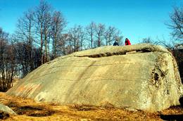
Mūgas Kabelikivi akmensPēc tilpuma (728 m3) - otrs lielākais Baltijas dižakmens. Baltijā vienīgais akmens ar šādu formas un izmēra apvienojumu. Tā augstums ir 7 m, garums – 19 m, platums – 11 m, bet apkārtmērs – 58 m. Kabelikivi atgādina līdz pusei zemē ieraktu milzu klints gabalu. Ledājs to „atnesis” no Somijas D daļas. Pēc sastāva - rapakivi granīts. Tam blakus atrodas vēl 2 visnotaļ iespaidīgi dižakmeņi.
|
 |
Igaunija
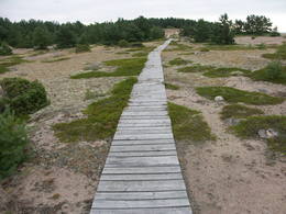
Ērdi taka (Öördi rada)1,2 km gara taka, kas pa purvainu mežu aizved līdz Ērdi purvam (Öördi raba) un tā austrumu daļā esošajam Ērdi ezeram (Öördi järv), pie kura izveidota atpūtas un peldvieta. |
 |
Igaunija
Vīdumē rezervātsVeidots Ancilus ezera (viena no Baltijas jūras attīstības stadijām) un tā noskalotā senkrasta, tā piekājē un apkārtnē esošo mitrāju, mežu un floras (t.sk. endēma augu suga) aizsardzībai.
Pakalpojumi
244km - Attālums no valsts galvaspilsētasPakalpojumi - atpūta
Dabas takaVīdumē mācību taka (1,2 km), Audaku pārgājienu taka (2,8 km); 
Dabas vērošanaSkatu tornis Vīdumegi (Viidumägi) kalnā ar plašu skatu uz Sāremā (Saaremaa) salas R daļu. Vērts iegriezties apmeklētāju centrā, kas atrodas Audaku. |
|
|
Igaunija
Lemmjē pārgājienu taka (Lemmjõe matkarada)Taka, kas izveidota Lemmjegi (Lemmjõgi) un Raudnas (Raudna jõgi) satekas vietā, iepazīstina ar palieņu pļavām un veciem pārmitriem mežiem, kas ir vieni no lielākajiem Igaunijā. Takas sākumā dominē atklātas lauku ainavas. Viens no 4,9 km garās lokveida takas apskates objektiem ir Lemjē dižozols. Mitrā laikā noderēs ūdensizturīgi apavi. 155
Pakalpojumi
155km - Attālums no valsts galvaspilsētas |
 |
Igaunija
Mohni sala (Mohni saar)Igaunijas jūras ūdeņos ir saskaitīta 1521 sala! Salu sarakstā pēc platības (63 ha) ~ 2,5 km garā Mohni sala ieņem 38. vietu. Lai saudzētu salas trauslo veģetāciju (vietām nedaudz atgādina krūmainu tundru), tās vidusdaļā ir izveidotas koka laipas. Salas dienviddaļā atrodas sašaurinājums, kuru tāpat kā blakus esošo jūras krastu klāj viens no savdabīgākajiem Igaunijas akmeņu laukiem. Salas ziemeļos esošās Mohni bākas (Mohni tuletorn) celtniecība pabeigta 1871. g. un tās gaisma ir redzama 10 jūras jūdžu attālumā. Šī ir viena no skaistākajām Ziemeļigaunijas bākām! Līdz Mohni salai var nokļūt ar laivu (iepriekšēja pieteikšanās) no ~ 5 km attālās Vīnistu ostas (Viinistu sadam). Ar jūras laivu vai kajaku piemērotos apstākļos būs ~ 1h ilgs brauciens. Jārēķinās, ka uz salas nav pastāvīgo iedzīvotāju! Vīnistu ciemā apskatāms 2002. g. izveidotais Vīnistu mākslas muzejs (Viinistu kunstimuuseum). Apmeklētājus iespaidos ne tikai tā āriene, bet arī tapšanas vēsture. 76
Pakalpojumi
76km - Attālums no valsts galvaspilsētas |
 |
Igaunija
Mejekoses pārgājienu taka (Meiekose matkarada)~ 3 – 5 km gara taka, kas ved pa veco ceļu gar Tēramā upes (Tõramaa jõgi) kreiso krastu. Takas malās izvietoti interaktīvi elementi bērniem, kas palīdz labāk uztvert dabā notiekošo. Taku ieskauj mitrie meži un palieņu pļavas, kas palu laikā atrodas zem ūdens. Tēramā (Tõramaa) ciemā apkārtnē atrastas cilvēka darbības pēdas jau no akmens laikmeta. 149
Pakalpojumi
149km - Attālums no valsts galvaspilsētas |
 |
Igaunija
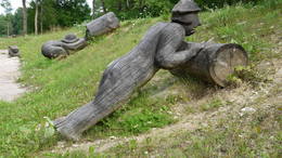
Vikingu ciematsUnikālais tematiskais parks pirmatnējās Piritas upes krastā ir izveidots ar mērķi apmeklētājiem raisīt interesi par seno vikingu diženumu. Iespējas: vikingu pils, buršanās slietenis, smēde, senlaiku spēles, teatralizēti uzvedumi, izbrauciens vikingu kuģi pa Piritas upi bagātību meklējumos, vizināšanās vienkoču laivās, kaujas ar akmeņu metamām ierīcēm, loka šaušana, cirvja mešana, alas un melnā pirts, foreļu makšķerēšana, ekstrēma nakšņošana, ēdināšana u.tml.  30
30
 1-12 1-12
Pakalpojumi
30km - Attālums no valsts galvaspilsētas
1-12 Aktīvie sezonas mēneši |
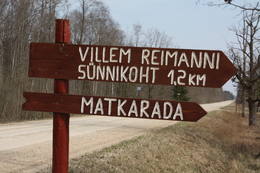 |
Igaunija
Paunas taka (Pauna rada)Kultūrvēsturiska taka (garums ~ 2 km) Tipu (Tipu) ciemā, kas iepazīstina ar vairākiem interesantiem objektiem: veco skolu (1931. g.), Hallistes upi, pirti un Paunas saimniecību, kurā dzimis viens no Igaunijas nacionālās kustības līderiem Villems Reimans (1861. – 1917.). |
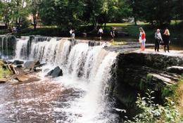 |
Igaunija
Keilas ūdenskritumsViens no Igaunijas ainaviskākajiem ūdenskritumiem – līdz 6 m augsts un līdz 50 m plats. Straujā Keilas upe aiz ūdenskrituma izveidojusi klinšainu kanjonu un tecējumu ar lielu kritumu, tādēļ pa Keilas parku vērts aiziet līdz ~ 1 km attālajam Somu līča krastam un atgriezties gar upes otru krastu.
|
 |
Igaunija
Ignatsi pārgājienu taka (Ignatsi matkarada)Taka iesākumā ved pa mežu ieskautu bijušo šaursliežu dzelzceļa līniju, pa kuru pagājušā gadsimta vidū izveda kokmateriālus. Tās tālākā daļa izmet nelielu loku pa Suistna purvu (Suistna raba), kur uzcelts skatu tornis ar izcilu sūnu purva ainavu ar nelieliem ezeriņiem. Takas garums vienā virzienā ir 4,5 km. |
 |
Igaunija
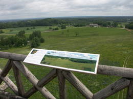
Lahemā nacionālais parksPirmais Igaunijas un Baltijas nacionālais parks – dibināts 1971. g. Veidots Somu līča piekrastes, mežu, purvu, pļavu biotopu, sugu, dabas pieminekļu – dižakmeņu, ūdenskritumu, atsegumu un kultūras pieminekļu – senkapu, pilskalnu, muižu, zvejniekciemu u.c. objektu aizsardzībai.
Pakalpojumi
50km - Attālums no valsts galvaspilsētasPakalpojumi - atpūta
Apvidus slēpošanaKesmu pussalā 
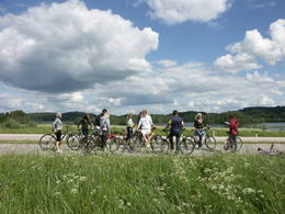
VelomaršrutsKesmu (Käsmu) pussalā (~ 10 km), Pärispea pussalā: Loksa – Pärispea – Viinistu – Kasispea (te Baltijas augstākais dižakmens – Jaani – Tooma kivi, 7,8 m) - Vihasoo – Kotka – Loksa (~ 40 km);
Dabas takaViru purva (Viru raba) laipu taka (3,5 km), pastaigu takas Kesmu (Käsmu) pussalā (kopā ~ 15 km), Pikanõmme – Majakivi taka (4,5 km) ar 3. lielākā (584 m3) Baltijas dižakmens – Mājas akmens (Majakivi) apskati, Altjas (Altja) izziņas taka (3 km);
Dabas vērošanaSkatu torņi Viru raba purvā un Pikanõmme – Majakivi takā. Apmeklētāju centrs atrodas Palmse. |
 |
Igaunija
Leti tornis (Läti torn)Jēsū – Kepu ceļa malā pie Leti (Läti) ciema ir izveidots autostāvlaukums ar putnu vērošanas torni, no kura paveras skats uz Hallistes upes palieņu pļavām un tuvējā ciema apkārtni. Stipru palu laikā arī no šī torņa redzamā apkārtne (izņemot ceļus) var atrasties zem ūdens. Laba putnu vērošanas vieta. Läti tulkojumā no igauņu valodas nozīmē Latvija. |
 |
Igaunija
Karulas nacionālais parksParks atrodas Karulas augstienes paugurainajā apvidū, kura vidusdaļā iegūlis Ähijärve ezers. Parks veidots kultūrvides, ainavas ar nelielām lauku sētām un savdabīgo kupolveidīgo pauguru aizsardzībai.
Pakalpojumi
280km - Attālums no valsts galvaspilsētasPakalpojumi - atpūta
Makšķerēšana
VelomaršrutsVelo maršruts- Ähijärve – Peräjärve – Kolski – Rebasemõisa – Kaika – Ähijärve (26 km).
Dabas takaÄhijärve dabas taka (3,5 km), Rebase ainavu taka (7 km), Peräjärve dabas taka (4 km).
Dabas vērošanaSkatu torņi Tornimägi kalnā un Mäekonnu skatu tornis. Apmeklētāju centrs atrodas Ähijärve ciemā. Informācija: www.karularahvuspark.ee. |
 |
Igaunija
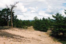
Aegnas salaViscaur mežiem klāta sala Somu līcī ~ 14 km Z no Tallinas. Salu caurauž nelielu ceļu un taku tīkls. Ieteicams pārgājiens apkārt mainīgajai (kāpas, smilšaini, akmeņaini un ar niedrēm apauguši krasta posmi) salas piekrastei (~ 9 km). Kuģītis atiet no Piritas ostas.
|
 |
Igaunija
Saleveres Salumegi kalns (Salevere Salumägi)Litorīnas jūras laikā (pirms ~ 6000 gadiem) Saleveres Salumegi kalns bija sala, bet mūsdienās tas kā izteikta kāple (īpaši - ziemeļu pusē) paceļas virs Piejūras līdzenuma. Salumegi ziemeļu pusē slejas 4 - 5 metrus augsts kaļķakmens atsegums – silūra perioda (> 400 mlj. gadu) koraļļu rifa paliekas, kuru noskalojuši Litorīnas jūras viļņi. Atseguma piekājē izplūst Acu avots, kam piedēvē dziednieciskas īpašības. Salumegi apskates nolūkos izveidota lokveida taka (1,5 km). No kalna augšas paveras labs skats uz Matsalu līci. Šeit atradies arī sens pilskalns. 132
Pakalpojumi
132km - Attālums no valsts galvaspilsētas |
 |
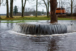
Igaunija
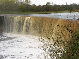
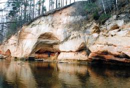
Jegalas ūdenskritumsViens no izcilākajiem Baltijas ūdenskritumiem – ap 8 m augsts un līdz 70 m plats (iespaidīgāks pavasaros un pēc lietavām). Ūdenskritums un tam sekojošais ~ 300 m garais kanjons veidojies Ordovika perioda kaļķakmeņos, kuros zinātājs saskatīs galvkāju u.c. fosīlijas. Mazūdens periodā drosmīgākie mēģina šķērsot upes straumi gan virs ūdenskrituma, gan arī zem tā, kur kaļķakmens pārkares un krītošais ūdens ir izveidojuši savdabīgu „tuneli”.
|
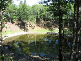 |
Igaunija
Kaali meteorīta krāterisViens no Eiropas iespaidīgākajiem krāteru laukiem. Galvenā krātera dziļums ir 22 m, diametrs – 110 m. Meteorīts nokritis pirms ~ 7,5 tūkstošiem gadu. 205
Pakalpojumi
205km - Attālums no valsts galvaspilsētas |
|
|
Igaunija
Hiiumaa salaOtra lielākā Igaunijas sala ar plašiem mežu masīviem, smilšainām un akmeņainām pludmalēm un vienu no Eiropas vecākajām bākām. 132
Pakalpojumi
132km - Attālums no valsts galvaspilsētas |
 |
Igaunija
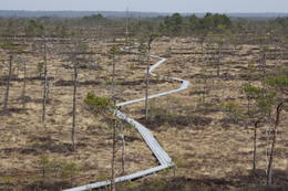
Tuhalas dabas centrs un Raganas aka (Nõiakaev)Tuhalas apkārtne ir apdzīvota vismaz 3000 gadus. Šeit ir atrastas 11 senas apmetnes, 30 kulta akmeņi, 3 akmens senkapi, 4 svētbirzes u.c. Tuhalas lieguma teritorijā atrodas unikālā Nõiakaev (Raganas aka), kas palu laikā “vārās” un izmet 100 litrus ūdens sekundē, kā arī pieci Igaunijas spēcīgākie enerģijas stabi. Pa pastaigu ceļu, kas šķērso Tuhalas karsta procesu teritoriju (2,5 km), var iet kājām, vai braukt ar velosipēdu un automobili. Šis ceļš ir piemērots pastaigām kopā ar ģimeni. 32
1-12
Pakalpojumi
32km - Attālums no valsts galvaspilsētas
1-12 Aktīvie sezonas mēneši |
 |
Igaunija
PīrisārePīrissāre ir 7,5 km² liela pastāvīgi apdzīvota Peipusa ezera sala. Pārsvarā šeit uz dzīvi ir apmetušies krievu vecticībnieki, kas vairākus gadsimtus rūpējas par savas savdabīgās kultūras saglabāšanu. Iedzīvotāji galvenokārt nodarbojas ar zvejniecību. Uz lauksaimniecībai piemērotas zemes audzē dārzeņus, visvairāk – sīpolus. Uz Pīrisāri no Lāksāres ostas var nokļūt ar prāmi "Koidula" (tālr.: +372 527 2974, www.veeteed.com). 262
1-12
Pakalpojumi
262km - Attālums no valsts galvaspilsētas
1-12 Aktīvie sezonas mēneši |
 |
Igaunija
Tammispeas akmens (Tammispea kivi)Tikpat iespaidīgs, taču ne tik populārs tūrisma objekts kā netālu esošais Jāņa – Toma akmens. Tammispeas akmens iegūlis mežā, tāda paša nosaukuma nelielā ciemā, kas atrodas Eru līča (Eru laht) dienvidu krastā. Tilpuma ziņā (262 m3) – 16. lielākais Igaunijas dižakmens. Tā garums ir 10,7 m, platums – 6,5 m, augstums – 7,5 m, bet apkārtmērs – 27,8 m. Iespaidīgas ir arī šī akmens atlūzas. Ar šī akmens attēlu noteikti ir jāpapildina sava lielāko Baltijas dižakmeņu fotokolekcija. 70
Pakalpojumi
70km - Attālums no valsts galvaspilsētas |
 |
Igaunija
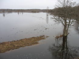
Soomā nacionālais parks1993. gadā dibinātais Soomā nacionālais parks aizsargā lielo purvu masīvus, palienes pļavas un mežus. Parka apmeklētāju centrā ir pieejama informācija par pārgājienu takām un vietējiem pakalpojumiem. Pieejamas vairāk kā 10 dabas takas un skatu torņi. Šeit varat iepazīties ar pastāvīgo ekspozīciju un doties tematiskā mācību pārgājienā par bebru dzīvi. Soomā ir plaši pazīstams vērienīgo plūdu (martā un aprīlī) dēļ, ko sauc par piekto gadalaiku. Plūdu laikā pa Soomā mežiem, pļavām un upēm tiek organizēti pārgājieni ar kanoe laivām un vienkocēm (www.soomaa.com). Te var apgūt vienkoču grebšanas prasmi un piedalīties nometnēs. Pakalpojumi
150km - Attālums no valsts galvaspilsētas
1-12 Aktīvie sezonas mēnešiPakalpojumi - atpūta
Makšķerēšana
Apvidus slēpošanaApvidus slēpošana un purva šķērsošana ziemā. Apmeklētāj centrs atrodas Tõramaa. Informācija: www.soomaa.com, www.soomaa.ee 
Izbraukumi ar kuģīti/laivuBraucieni ar kanoe laivām pa applūdušajām teritorijām un nacionālā parka upēm.
Dabas takaWalking tours in the park
Dabas takaGidēts pārgājiens „purva kurpēs”, Riisa purva taka (5 km) ar skatu torni , Ignatsi pārgājienu taka (4,5 km) ar skatu torni , Bebru izziņas taka (3 km), Tõramaa taka (2,5 km) ar skatu torni u.c. takas un maršruti.
Dabas vērošanaBebru safari, dzīvnieku vērošana gida pavadībā. |
 |
Igaunija
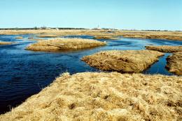
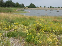
LuitemāTulkojumā no Igauņu valodas Luitemaa nozīmē „Kāpu zeme”. Piekrastes teritorija 13 km garumā starp Vöiste un Häädemeeste ar seklūdeņiem, plašām piejūras pļavām, Igaunijas augstāko kāpu masīvu un Tolkuses purvu (Tolkuse raba). Nozīmīga putnu vieta.
|
 |
Igaunija
Kesmu pussala (Käsmu poolsaar)Ar skujkoku mežiem klāta pussala – piemērota vieta kājāmiešanai un braucieniem ar divriteni. Te izveidots velomaršruts, kas no Kesmu ciema (Käsmu küla) aizved līdz Kesmu ezeram (Käsmu järv) un tālāk gar pussalas rietumu uz ziemeļu piekrasti aizlokas atpakaļ līdz minētajam ciemam. Tas gan nav domāts iesācējiem, jo vietām ceļi ir smilšaini, bet krasta ceļš var būt aizgāzts ar kritušiem kokiem. Kesmu pussalas ziemeļu daļā atrodas izcilais Kesmu akmeņu lauks (Käsmu kivikülv). Lielākais no akmeņiem ir Matsikivi akmens (tilpums -132,9 m3). Ziemeļos no Kesmu ciema jūras krastā uzmeklējams iespaidīgu akmeņu „bariņš” Iespaidīgākais no tiem ir Vecā Jura akmens (Vana Jüri kivi), kura augstums ir 5,5 m, bet tilpums - 102,9 m3. Piemērotos laika apstākļos (g.k. vasarās) pa akmeņainu strēli var aiziet vai aizbrist līdz ~ puskilometru attālajai Sārtnēmes (Saartneem) saliņai. Atpakaļceļā uz ciemu var atstāt savu akmeni „Laimes akmeņu kaudzē”. Kesmu ziemeļdaļas apskatei izveidots 4,5 km garš kājnieku tūrisma maršruts. Kesmu kapteiņu ciemā (Käsmu kapteniküla) 1804. g. nodibināja pirmo Igaunijas jūrskolu un laikā no 1798. – 1920. g. uzbūvēja > 40 kuģus. Atrodamas ziņas, ka no nedaudz vairāk par 100 no šeit kādreiz dzīvojošajām ģimenēm ir nākuši 62 kapteiņi. Bijušā jūrskolas ēkā izveidots Jūrniecības muzejs. Netālu apskatāma Kesmu kapela. 81
Pakalpojumi
81km - Attālums no valsts galvaspilsētas |
 |
Igaunija
Otepē dabas parksAtrodas Otepē augstienes R daļā. Viens no izciliem piemēriem, kā aizsargājamas dabas teritorijas vērtības un reljefs tiek izmantots rekreācijas, sporta un aktīvās atpūtas vajadzībām, jo parkā ir izveidota šim mērķim atbilstoša un kvalitatīva infrastruktūra.
PakalpojumiPakalpojumi - atpūta
Apvidus slēpošanaSlēpošana 63 km garajā Tartu maratona trasē, kas šķērso parku.
VelomaršrutsVelo maršruts apkārt Pühajärv ezeram no Otepē centra (~ 20 km), Otepää – Kääriku (11 km).
Dabas takaPārgājiens apkārt Pühajärv ezeram (12 km), Kekkose pārgājienu maršruts (14 km), Murrumetsa pārgājienu taka (3,5 km).
Dabas vērošanaSkatu torņi Harimägi, Kuutsemägi kalnos, pie Otepē tramplīna un skati no Väike Munamägi un Otepē pilskalna. Informācija: www.otepaaloodus.ee. |
 |
Igaunija
Vehandu upes senlejaViena no skaistākajām Igaunijas upju senlejām – 12 km gara ar gandrīz 40 ainaviskiem Devona perioda smilšakmens atsegumiem, no kuriem īpaši jāpiemin Viira müür, Kalamatu müür un Põdramüür.
|
 |
Igaunija
Vientiešu tematiskais parksBijušajā Mīslera muižas parkā ir izveidots savdabīgs tematiskais ciemats, kur visas atrakcijas ir saistītas ar leģendām par vientiešiem, kas bija pazīstamas Vācijā jau pirms 400 gadiem.Vientieši ir jokdaru tēli, kas kļuva slaveni ar savu nepraktisko, bezjēdzīgo rīcību un anekdotiskajām izdarībām.Šeit Jūs varēsiet piedalīties vientiešu anekdotiskajos piedzīvojumu pārgājienos, darboties meistaru darbnīcās, nopirkt kādu vietējo suvenīru, ieturēt maltīti (grupām pēc iepriekšējā pasūtījuma) un pārnakšņot teltīs. 107
1-12
Pakalpojumi
107km - Attālums no valsts galvaspilsētas
1-12 Aktīvie sezonas mēneši |


