
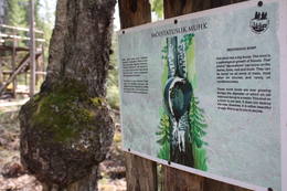
Naturobjekte in Estland

Was ist das Besondere an der Natur in Estland?
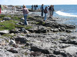
In Estland steht die beeindruckendste Felswand im Baltikum - das sogenannte nordestnische "Glitzern" (aus estnischer Sprache). Estland hat sein eigenes "Land der Buchten" - die Region Lahemaa mit ihrem Nationalpark, das "Land der Inseln" - die Insel Saaremaa und den Monzund-Archipel. Die Matsalu-Bucht ist eine der wichtigsten Raststätten für Vögel während ihrer Wanderung. In Estland gibt es einen der bekanntesten Einschlagkrater in Europa, es gibt die größten Wasserfälle und Felsbrocken im Baltikum, den Munamagi-Hügel - den höchsten Punkt im Baltikum, den Peipus-See - den fünftgrößten See in Europa - mit langen Hervorragende Fischertraditionen und die Vielfalt der Natur von West nach Ost, von Nord nach Süd.
Handle verantwortungsbewusst - folge dem Grünen Rat!
| Überblick | Details |
|---|---|
 |
Estland
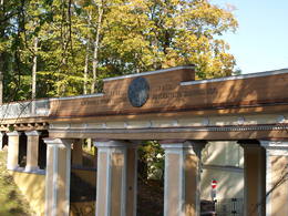
Domberg TartuVom 19. Jh. ist der Domberg ein offentlicher Park mit Pfaden, Gehwegen, Brücken (Engelsbrücke, Teufelsbrücke) und den Denkmälern für die Wissenschaftler der Tartu Universität. Hier befinden sich die Domkirche, das Anatomicum, das Observatorium u.a. interessante Objekte.  185 185
Leistungen
185km - Entfernung von der Hauptstadt |
 |
Estland
Nationalpark VilsandiWurde für den Schutz der Inselgruppe Vilsandi (ung. 100 kleine Inseln) gegründet. Die größte ist 6 km lange un bis 2 km breite Vilsandi Insel. Leistungen
255km - Entfernung von der HauptstadtLeistungen - erholung
Fahrten mit Schiff/BootBoat along the islands of the archipelago, but keep in mind that the Vaika Island and the Nootamaa Island are nature reserves which are closed to visitors. 
NaturpfadHike the route Loona-Kuusnõmme (8 km), hike around the Vilsandi Island (~12-15 km), hike the Harilaid peninsula (~10 km). 
NaturbeobachtungBird-watching from the southern end of the Vilssandi Island – the nearby Vaika Island is closed to visitors. There is a viewing tower on the N end of the Kuusnõmme peninsula. The visitor centre of the park is found at the Loona estate (Loona mõis). |
 |
Estland
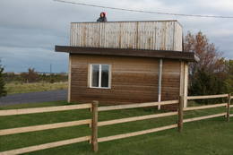
Putnu verosanas tornis Puises ragaPuises ragā (Puise nina) ir uzcelts divstāvīgs atpūtas nams, kas apvienots ar putnu vērošanas torni. No tā paveras skats uz piekrasti, kas ir iecienīta migrējošo zosu atpūtas vieta. Šī ir privāta teritorija, kuras apskati vēlams saskaņot ar īpašnieku. 123
Leistungen
123km - Entfernung von der Hauptstadt |
 |
Estland
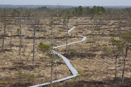
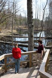
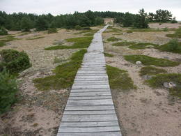
Moorpfad ViruEin 3,5 km langer Pfad quert den Viru Moos in Richtung Süd–Nord. Von einem Holzaussichtsturm eröffnet sich einen Blick auf eine typische Hochmoorlandschaft mit einigen Seen, Aushöhlungen und morastigen Stellen. 56
Leistungen
56km - Entfernung von der Hauptstadt |
 |
Estland
Insel HiiumaaDie zweitgrößte Insel Estlands mit breiter Waldung, Sand- und Steinstränden und einem der ältesten Leuchttürme Europas. 132
Leistungen
132km - Entfernung von der Hauptstadt |
 |
Estland
Naturschutz-gebiet ViidumäeWurde für den Schutz der seltenen Pflanzenarten (auch endemische) und Biotopen an der alten Uferlinie vom Ancilus See gegründet. Leistungen
244km - Entfernung von der HauptstadtLeistungen - erholung
NaturpfadThe Viidumäe educational trail (1.2 km), the Audaku hiking trial (2.8 km).
NaturbeobachtungThere is a viewing tower on Mount Viidumägi with a broad view of the western end of the Saaremaa Island. It’s worth visiting the visitor centre at Audaku. |
 |
Estland
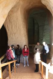
Ancient Piusa River valley and Piusa caveThe area of the ancient Piusa River valley that is between the villages of Vana-Vastseliina and Ignasõ is around 15 km long, features some substantial rapids, and offers a view of beautiful Devonian period cliffs. The largest, Härma müür, is 43 metres high and is the highest sandstone cliff in Estonia. There are caves from old mines in the village of Piusa. A small part of the mines, which have tunnels that are more than 10 km long in all, has been tured into a local museum.
LeistungenLeistungen - erholung
Fahrten mit Schiff/BootBoat from Vana-Vastseliina to Ignasõ (1 day, extreme boating, only during flood season). For more information: www.piusa.ee (available in English).
NaturpfadHike down the river valley along its entire length (~20 km). |
 |
Estland
Naturzentrum von Tuhala und HexenbrunnenDer Ort Tuhala ist schon seit 3000 besiedelt. Im Gebiet befinden sich 11 prähistorische Siedlungsreste, 30 Opfersteine, 3 Hügelgräbe, 4 Heiden u.a. Im Landschaftsschutzgebiet Tuhala befindet sich der unikale Hexenbrunnen, aus dem beim Hochwasser bis 100 l Wasser herauskocht, und fünf Estlands mächtigste Energiesäulen. 32
 1-12 1-12
Leistungen
32km - Entfernung von der Hauptstadt
1-12 Aktive Saisonmonate |
 |
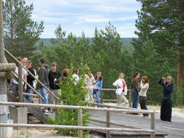
Estland
Wanderzentrum von Lahemaa matkakeskusWanderzentrum von Lahemaa beschäftigt sich mit Popularisierung von Naturschutz und Natururlaub – wir pflantzen Bäume, bauen und stellen Nistkatsen auf. Unseren Gästen bieten wir Kanuwanderungen, Moorwanderungen und Abenteuer auf Geländebogen- und Geländearmbrustpfad im Nationalpark Lahemaa an. Für gemütliches Relaxen gibt es einen Kaminraum und Sauna mit Badefass. 70
1-12
Leistungen
70km - Entfernung von der Hauptstadt
1-12 Aktive Saisonmonate |
 |
Estland
Ehijervs (Ähijärv)Karulas nacionālā parka lielākais ezers - 2,8 km garš, līdz 1 km plats. Ezera ziemeļaustrumu krastā atrodas parka apmeklētāju centrs. 5,5 m dziļais ezers ir gan zivīm, gan nostāstiem bagāta vieta. Ezera un tuvākās apkārtnes iepazīšanas nolūkā ir izveidota 3,5 km garā Ehijerva taka (Ähijärve teerada). Tās sākums atrodas pie iepriekš minētā apmeklētāju centra, kur izveidota atpūtas vieta un atraktīvs bērnu spēļu laukums. Taka sākumā ved gar ezera krastu, nelieliem mitrājiem un meža ceļiem, kas izmantoti iepriekšējos gadsimtos. |
 |
Estland
Skatu platforma Puises ciemaPuises „centrā” uz vienstāvu koka mājiņas jumta izveidota skatu platforma. No tās paveras laba ainava uz ciemu, ostu un piekrastes kadiķu laukiem. 121
Leistungen
121km - Entfernung von der Hauptstadt |
|
|
Estland
Skizentrum OtepääDas größte im Baltikum. Marathonloipe von Tartu, Wand der künstlichen Felsen und Trasse der Radmarathon. Skimuseum. Auf der Tehvandi-Sprungschanze ist ein Aussischtsplatform eingerichtet. 225
Leistungen
225km - Entfernung von der Hauptstadt |
 |
Estland
Torna kalns (Tornimägi)Karulas augstienes augstākais reljefa punkts (137 m.vjl.), kas virs tuvākās apkārtnes paceļas par ~ 60 m. Torņa kalnā ir uzbūvēts skatu tornis ar ļoti plašu apkārtskatu. Uz tā platformas ir novietoti panorāmas fotoattēli, kuros atzīmēti zīmīgākie plašākā apkaimē redzamie objekti – apdzīvotas vietas, pilskalni, baznīcu torņi u.c. Turpat izveidota atpūtas vieta un meklējams Rebases ainavu takas sākums. 260
Leistungen
260km - Entfernung von der Hauptstadt |
 |
Estland
Ignatsi pargajienu taka (Ignatsi matkarada)Taka iesākumā ved pa mežu ieskautu bijušo šaursliežu dzelzceļa līniju, pa kuru pagājušā gadsimta vidū izveda kokmateriālus. Tās tālākā daļa izmet nelielu loku pa Suistna purvu (Suistna raba), kur uzcelts skatu tornis ar izcilu sūnu purva ainavu ar nelieliem ezeriņiem. Takas garums vienā virzienā ir 4,5 km. |
 |
Estland
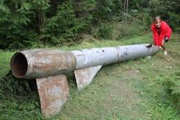
Kap JumindaDer weiteste Nordpunkt der Juminda Halbinsel mit einer Raketen-Attrappe der Sowjetarmee, der alten Grabstätten, dem Juminda-Leuchtturm und einem Denkmal für die Opfern des Zweiten Weltkriegs. 69
Leistungen
69km - Entfernung von der Hauptstadt |
 |
Estland
Bebru taka (Koprarada)Divus kilometrus garās lokveida takas sākums ir meklējams pie Somā nacionālā parka apmeklētāju centra (atklāts 2000. gadā) – Tēramā ciemā. Tā ved gar Mardu strauta (Mardu oja) krastu, kur krustām šķērsām ir sakrituši bebru nogāztie koki, radot diezgan juceklīgu skatu. Apmeklētāju centrā var iegūt nepieciešamo informāciju, noskatīties videofilmu un nacionālajam parkam veltītu ekspozīciju. 171
Leistungen
171km - Entfernung von der Hauptstadt |
 |
Estland
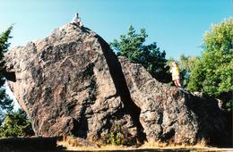
Stein Jaani - ToomaEiner der größten Feldsteine im Baltikum (bis 8 m). 72
Leistungen
72km - Entfernung von der Hauptstadt |
 |
Estland
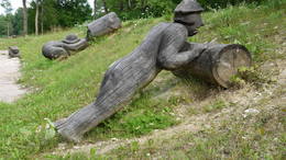
Themenpark der SchildbürgerIm ehemaligen Gutshofpark von Müüsleri befindet sich eigenartiger Themenpark "Dorf der Schildbürger". Die Attraktionen im Park sind verbunden mit den Sagen von Schildbürgern, die schon vor 400 Jahren in Deutschland bekannt waren. Schildbürger sind Figuren aus einem Witzbuch, berühmt durch ihr unzweckmässige, irrsinnige Tätigkeit und Streiche. Im Themenpark werden humorvolle Erlebnistouren, Basteln, Verpflegung (für Gruppen auf Voranmeldung), Shopping und Zelten angeboten. 107
1-12
Leistungen
107km - Entfernung von der Hauptstadt
1-12 Aktive Saisonmonate |
 |
Estland
Moor TolkuseDurch das höchste Dünen-Massiv Estlands und den Moor führt der Lehr-Wanderweg. Blick vom Aussichtsturm bis auf die Insel Kihnu. 175
Leistungen
175km - Entfernung von der Hauptstadt |
 |
Estland
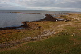
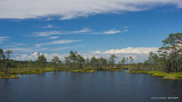
LuitemaaThe word “Luitemaa” means “land of the dunes” in Estoninan. This coastline territory stretches for 13 km between Vöiste and Häädemeste with shallow waters, large coastal plains, Estonia’s highest dunes, and the Tokuse swamp (Tokuse raba). There are lots of birds here.
|
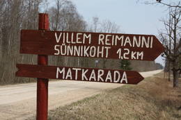 |
Estland
Paunas taka (Pauna rada)Kultūrvēsturiska taka (garums ~ 2 km) Tipu (Tipu) ciemā, kas iepazīstina ar vairākiem interesantiem objektiem: veco skolu (1931. g.), Hallistes upi, pirti un Paunas saimniecību, kurā dzimis viens no Igaunijas nacionālās kustības līderiem Villems Reimans (1861. – 1917.). |
 |
Estland
Felsen PangaDie höchste Felsenwand der estnischen Inseln (21 m hoch), ausgedehnt in die Länge von 2 km. Leistungen
230km - Entfernung von der HauptstadtLeistungen - erholung
NaturpfadHike along the foot of the cliffs (watch for falling rocks) in one direction, and then along the top of the cliffs along the other (~6 km).
NaturbeobachtungFrom the top of the cliff, you can see the Bay of Finland and the Tagaranna peninsula to the West. |
 |
Estland
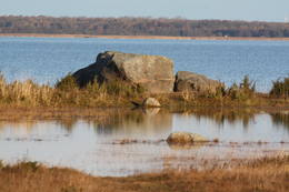
Neri akmeni (Näärikivid)Trīs lielāka izmēra laukakmeņi – aizsargājami dabas pieminekļi, kas atrodas Matsalu līča krastā starp Sāstnas (Saastna) un Metskjulas (Metsküla) ciemiem. Tuvējā ceļa malā ir izvietots informācijas stends un norādes, bet līdz akmeņiem var nokļūt pa iezīmētu taku. Pēc kāda tautas nostāsta, lielas vētras laikā, kas notikusi Jaungada naktī, lielais akmens sašķēlies trīs daļās. No tā arī cēlies vietvārds. Apkārtnē redzamās pļavas ir nozīmīga daudzu augu sugu dzīves vide un svarīga putnu ligzdošanas un atpūtas vieta. Šī iemesla dēļ taku drīkst apmeklēt tikai no 1. jūlija līdz septembra beigām. Akmeņi ir arī labi redzami no minētā ceļa. Tie ar ledāju atceļojuši no Turku (Somija) apkārtnes. 129
Leistungen
129km - Entfernung von der Hauptstadt |
 |
Estland
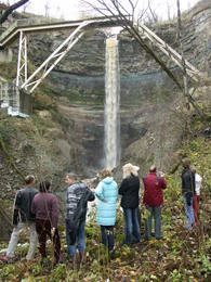
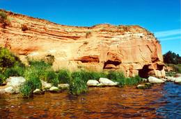
Saka-Ontika-Toila-pank (cliff)This is a cliff with various levels. Known as the North Estonian cliff, it stretches all along the shore of the Bay of Rīga in Estonia, including some of the local islands. The most expressive part in geological and landscape terms is the Saka-Ontika-Toila cliff, which is around 22 km long and offers an unusual natural environment. The cliff is as much as 53 m high, and it has a fairly virginal forest along its slopes. The layers of clay, sandstone, limestone, etc., come from the Cambrian and Ordovician periods. The Valaste juga (Valaste waterfall) is 24 metres high. After a longer period of freezing temperatures, the waterfall has a particularly impressive appearance. Seasonal waterfalls (8-10 m) can be found near the villages of Ontika and Toila.
LeistungenLeistungen - erholung
RadrouteBike from Saka to Taoil (20 km) along the road that is at the top of the cliffs.
NaturpfadHike along the seashore during the season when trees are bare, moving from Saka to Toila (~22 km).
NaturbeobachtungThere is an impressive viewing platform at the Valaste waterfall. |
 |
Estland
Kuranidu macibu taka (Kuuraniidu õpperada)1,7 km gara lokveida taka, kas iepazīstina ar dažādiem meža biotopiem, to iemītniekiem un meža apsaimniekošanas pamatprincipiem. Apmeklētāju ērtības nolūkā ir izveidotas koka laipas un neliels skatu tornis. 159
Leistungen
159km - Entfernung von der Hauptstadt |
 |
Estland
Mohni sala (Mohni saar)Igaunijas jūras ūdeņos ir saskaitīta 1521 sala! Salu sarakstā pēc platības (63 ha) ~ 2,5 km garā Mohni sala ieņem 38. vietu. Lai saudzētu salas trauslo veģetāciju (vietām nedaudz atgādina krūmainu tundru), tās vidusdaļā ir izveidotas koka laipas. Salas dienviddaļā atrodas sašaurinājums, kuru tāpat kā blakus esošo jūras krastu klāj viens no savdabīgākajiem Igaunijas akmeņu laukiem. Salas ziemeļos esošās Mohni bākas (Mohni tuletorn) celtniecība pabeigta 1871. g. un tās gaisma ir redzama 10 jūras jūdžu attālumā. Šī ir viena no skaistākajām Ziemeļigaunijas bākām! Līdz Mohni salai var nokļūt ar laivu (iepriekšēja pieteikšanās) no ~ 5 km attālās Vīnistu ostas (Viinistu sadam). Ar jūras laivu vai kajaku piemērotos apstākļos būs ~ 1h ilgs brauciens. Jārēķinās, ka uz salas nav pastāvīgo iedzīvotāju! Vīnistu ciemā apskatāms 2002. g. izveidotais Vīnistu mākslas muzejs (Viinistu kunstimuuseum). Apmeklētājus iespaidos ne tikai tā āriene, bet arī tapšanas vēsture. 76
Leistungen
76km - Entfernung von der Hauptstadt |
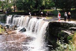 |
Estland
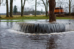
Wasserfall Keila - JoaEins der malerischen Wasserfälle Estlands. Der Wasserfall ist 6 m hoch und fast 50 m breit. Keila-Joa-Park. Leistungen
31km - Entfernung von der HauptstadtLeistungen - erholung
NaturpfadThe rapid Keila River has carved a cliffy canyon behind the waterfall, with a flow of water that falls down a major distance. It’s worth hiking through the Keila park to the shore of the Bay of Finland (~1 km), then returning along the other bank of the river. |
|
|
Estland
Burgberg OtepääEine sehr ausgeprägte und vom Mensch ausgebaute Reliefgestaltung mit breiter Sicht aufs Umland. Auf dem Burgberg steht die Ruine der 1224 vom Bischof Herman gebauten Burg. In den Ausgrabungen wurde die älteste Schußwaffe der Welt gefunden. 225
Leistungen
225km - Entfernung von der Hauptstadt |
 |
Estland
The sandstone cliffs of KallasteThis is one of the few places in the Baltic States where one can find Devonian period sandstone cliffs featuring abrasion caves, arches, etc. The cliffs are on the shores of Lake Peipsi (Peipsi järv), near Kallaste, and they are between two and four (in some cases – nine) metres high, stretching for a distance of around one km.
LeistungenLeistungen - erholung
NaturpfadHike along the shores of the lake to and from the cliffs (3 km).
NaturbeobachtungThere is a viewing tower which offers a good look at Lake Peipsi and the shoreline. For more information: www.kallaste.ee (only in Estonian). |
 |
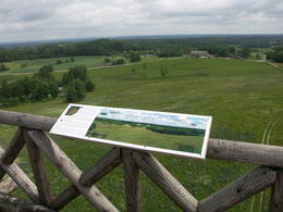
Estland
The Karula National ParkThis park is in a region of hillocks in the Karula highlands, and Lake Ähijärve is at its centre. The park offers a cultural environment of small farms, and it was set up to protect the unique cupola-shaped hillocks of the area. Main attractions: Scenic Lake Ähijärv (176ha), Rebasemõisa Tornimägi hill (137.8 m above sea level), undulating landscapes. Leistungen
280km - Entfernung von der HauptstadtLeistungen - erholung
Angeln
RadrouteBike the route Ähijärve-Peräjärve-Kolski-Rebasemõisa-Kaika-Ähijärve (26 km).
NaturpfadHike the Ähijärve nature trail (3.5 km), the Rebase landscape trail (7 km), or the Peräjärve nature trail (4 km).
NaturbeobachtungThere are viewing towers on Tornimägi hill and at Mäekonnu. The visitor centre is in the village of Ähijärve. For more information: www.karularahvuspark.ee (available in English). |


