
Nature objects in Estonia

Что особенного в природе в Эстонии?
В Эстонии стоит самая впечатляющая каменная стена в Балтии - так называемый северо-эстонский «глинт» (от эстонского языка). У Эстонии есть своя «Земля островов» - регион Лахемаа с национальным парком, «Земля островов» - остров Сааремаа и архипелаг Монцунд. Залив Матсалу является одной из наиболее значительных остановок для отдыха птиц во время их миграции. В Эстонии есть один из самых заметных ударных кратеров в Европе, самые большие водопады и валуны в Балтии, холм Мунамаги - самая высокая точка в Балтии, Чудское озеро - 5-е по величине озеро в Европе, - с длинной Постоянные рыболовные традиции и великое разнообразие природы с запада на восток, с севера на юг.
Действуй ответственно - следуй Зеленому совету!
| Overview | Details |
|---|---|
 |
Estonia
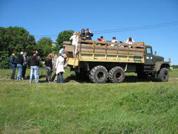
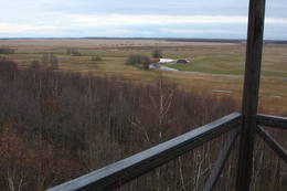
Kusnemmes pussala (Kuusnõmme poolsaar)Ap 6 km garā pussala ir vieta, kur jānokļūst tiem, kas grasās doties vienā no neparastākajiem pārgājieniem pāri jūras šaurumam. Cauri Kūsnemmes pussalai līdz tās ziemeļu daļai iet šaurs un ļoti līkumains grants ceļš (ar garāku tūristu autobusu jābrauc lēni un uzmanīgi), kura galā izveidots autostāvlaukums, neliels namiņš, kur patverties lietus un vēja laikā, kā arī informācijas stends. Turpat redzamas divas Padomju armijas „KRAZ” tipa automašīnas. Lai sasniegtu robežkontroles posteni, Padomju robežsargi brauca pa jūru un mazajām saliņām, kas kā pērļu virtene savieno Kūsnemmes pussalas galu ar Vilsandi salas dienviddaļu. Turpat divas desmitgades pēc Igaunijas neatkarības atjaunošanas „KRAZ” automašīnu kravas kastēs vasaras laikā uz Vilsandi vizināja tūristus, taču spēkrati savu mūžu ir nokalpojuši un unikālais piedāvājums vairs nav spēkā! Ko darīt? Pa mazajām saliņām uz Vilsandi var doties ar kājām. To var īstenot tikai siltā laikā, kad nav gaidāms stiprs vējš un ir zināma laika prognoze vismaz divām tuvākajām dienām. Kā sava veida orientieris var kalpot augstsprieguma elektrolīnija. Kopumā ir jārēķinās arī ar 1 h 40 – 2 h ilgu un ~ 4 km garu gājienu. Dziļākā vieta (ja ietur pareizo „kursu”) atrodas pārgājiena sākumdaļā, kur starp saliņām izveidots laivu ceļš - ~ 1 m dziļa vieta atkarībā no vēja virziena un ūdens līmeņa. Zināmu priekšstatu par maršrutu sniegs redzamā ainava, kas paveras no skatu torņa. Kaut arī šis maršruts tiek reklamēts dažādos informatīvajos materiālos, atbildību par tā veikšanu uzņemas katrs pats!  257 257
Services
257km - Distance from countries capital city |
 |
Estonia
Suitsu tornis (Suitsu torn)Suitsu tornis celts 1979. g. kā pirmais Matsalu rezervāta metāla tornis. To atjaunoja 1998. g. Torņa augstums ir 21 m, tādēļ no tā paveras izcila dabas un kultūrainava uz Kazari deltas niedrājiem un blakus esošo Suitsu upi (Suitsu jõgi), kuras krastā ir uzceltas vairākas zvejnieku laivu būdas. |
 |
Estonia
Leti tornis (Läti torn)Jēsū – Kepu ceļa malā pie Leti (Läti) ciema ir izveidots autostāvlaukums ar putnu vērošanas torni, no kura paveras skats uz Hallistes upes palieņu pļavām un tuvējā ciema apkārtni. Stipru palu laikā arī no šī torņa redzamā apkārtne (izņemot ceļus) var atrasties zem ūdens. Laba putnu vērošanas vieta. Läti tulkojumā no igauņu valodas nozīmē Latvija. |
 |
Estonia
Neri akmeni (Näärikivid)Trīs lielāka izmēra laukakmeņi – aizsargājami dabas pieminekļi, kas atrodas Matsalu līča krastā starp Sāstnas (Saastna) un Metskjulas (Metsküla) ciemiem. Tuvējā ceļa malā ir izvietots informācijas stends un norādes, bet līdz akmeņiem var nokļūt pa iezīmētu taku. Pēc kāda tautas nostāsta, lielas vētras laikā, kas notikusi Jaungada naktī, lielais akmens sašķēlies trīs daļās. No tā arī cēlies vietvārds. Apkārtnē redzamās pļavas ir nozīmīga daudzu augu sugu dzīves vide un svarīga putnu ligzdošanas un atpūtas vieta. Šī iemesla dēļ taku drīkst apmeklēt tikai no 1. jūlija līdz septembra beigām. Akmeņi ir arī labi redzami no minētā ceļa. Tie ar ledāju atceļojuši no Turku (Somija) apkārtnes. 129
Services
129km - Distance from countries capital city |
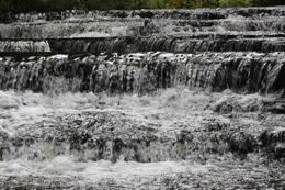 |
Estonia
Joaveski udenskritumi (Joaveski joastik)Krāčains Lobu upes (Loobu jõgi) posms pie Joaveski ciema, kur ~ 160 m garumā upes gultnē, tai šķērsojot Ziemeļigaunijas glintu, izveidojušās izmēros nelielas, tomēr ļoti ainaviskas un skaistas 0,5 – 1 m augstas ūdenskritumu kaskādes. 1898. g. šeit uzcēla hidroelektrostaciju, kuras atliekas ir redzamas upes labajā krastā. Iecienīta pavasara laivotāju treniņu vieta. |
 |
Estonia
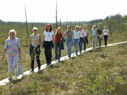
Meenikunno swampThis is a highland swamp with several little lakes. At the SE of the area is a wooden trail.
|
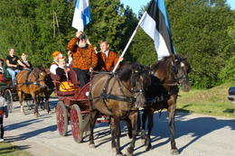 |
Estonia
Tihuse Riding Farm heritage trailTihuse farm provides accommodation and horse riding from trekking to carriage rides. A signposted heritage trail starts at the farm and tells the story of people and Nature; you can also learn about old beliefs and customs. The teahouse exhibits photos of places linked to Muhu island’s heritage. 148
 1-12 1-12
Services
148km - Distance from countries capital city
1-12 Active season months |
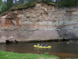 |
Estonia
Ancient Ajha River valleyThis ancient river valley stretches from Koorvere to the Otteni Windmill, and there are nearly 40 revealed sandstone cliffs from the Devonian age. Two of them, Väike and Suur Taevaskoja (the latter is 22 m high) are popular tourist destinations.
|
 |
Estonia
The blue streams of SaulaThree little lakes can be found on the left bank of the Pirita River with many erupting “eyes” of streams, each with its own colour (bluish-green, white, dark). This puts together various colour combinations. These are often known as the most beautiful streams in Estonia. Some pump out as much as 20-30 litres of water per hour. It is said that the waters are good medical resources, particularly for the eyes. There are improvements in the area of tourists.
|
 |
Estonia
The Vooremaa field of drumlinsThis is the most visually impressive drumlin field in the Baltic States, and it is close to the village of Tabivere. The drumlins were established by ice glaciers, and they point in the direction in which the ice moved long ago. In terms of their appearance, the drumlins resemble loaf-shaped hillocks. From their “backs,” there are lovely views of the local landscape and the lakes that are around the area. The visitor centre is in the village of Äksi.
|
 |
Estonia
Oksas (Oksa) takaBijušā piecstāvīgā metāla skatu torņa apkaimē plešas Lemmjegi upes palieņu pļavas. Netālu atrodas kādreizējā Oksas kroga (Oksa kõrts) vieta, kur saglabājies iespaidīgs manteļskurstenis. Apkaimes apskatei izveidota 0,8 km gara koka laipu taka. 175
Services
175km - Distance from countries capital city |
 |
Estonia
360° adventuresThe company runs wildlife tours: kayak trips at sea in summer, bogshoeing in bogs in autumn, snowshoeing trips in winter and canoeing on rivers in spring. 37
1-12
Services
37km - Distance from countries capital city
1-12 Active season months |
 |
Estonia
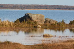
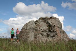
Halbinsel PärispeaAuf der Küste der Halbinsel befinden sich sowohl ehemalige Fischerdörfer, als auch die Reste eines Militärstützpunkts der Sowjetarmee. Großartige von den Gletschern des Eiszeitalters eingebrachte Feldsteine. 74
Services
74km - Distance from countries capital city |
 |
Estonia
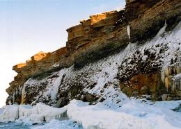
Felsen PakriDie mächtigste Steilküste im Baltikum (bis zu 24 m hoch). In den kalten Winter werden hier phantastische Gletscherstürze entstanden. Pakri Leuchtturm. 50
Services
50km - Distance from countries capital city |
 |
Estonia
Ehijervs (Ähijärv)Karulas nacionālā parka lielākais ezers - 2,8 km garš, līdz 1 km plats. Ezera ziemeļaustrumu krastā atrodas parka apmeklētāju centrs. 5,5 m dziļais ezers ir gan zivīm, gan nostāstiem bagāta vieta. Ezera un tuvākās apkārtnes iepazīšanas nolūkā ir izveidota 3,5 km garā Ehijerva taka (Ähijärve teerada). Tās sākums atrodas pie iepriekš minētā apmeklētāju centra, kur izveidota atpūtas vieta un atraktīvs bērnu spēļu laukums. Taka sākumā ved gar ezera krastu, nelieliem mitrājiem un meža ceļiem, kas izmantoti iepriekšējos gadsimtos. |
 |
Estonia
Bebru taka (Koprarada)Divus kilometrus garās lokveida takas sākums ir meklējams pie Somā nacionālā parka apmeklētāju centra (atklāts 2000. gadā) – Tēramā ciemā. Tā ved gar Mardu strauta (Mardu oja) krastu, kur krustām šķērsām ir sakrituši bebru nogāztie koki, radot diezgan juceklīgu skatu. Apmeklētāju centrā var iegūt nepieciešamo informāciju, noskatīties videofilmu un nacionālajam parkam veltītu ekspozīciju. 171
Services
171km - Distance from countries capital city |
 |
Estonia
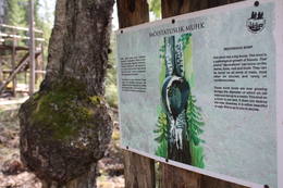
Gas mixtureGas mixture is the main raw material for Estonia’s energy and chemical industries, and it is extracted in our day from open quarries or underground shafts. This layer was established during the Ordovician Period between 450 and 480 million years ago, and it is made up of the remnants of plants and animals from that age. In the Kohtla-Nõmme suburb, there is a shaft which can be toured in the company of a guide who will tell you that this is the only layer of its kind in the Baltic States. He will tell you about how the gas mixture has been extracted over the course of history.
ServicesServices - recreational
Nature watchingIn the village of Kiviõli, in turn, you can climb an old hill of slag from the gas mixture (Vana tuhamägi). This will open up a view of one of Estonia’s most interesting landscapes. For more information: www.kivioli.ee (available in English). |
 |
Estonia
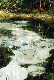
Tuhala Karst area, Witch’s wellOne of the largest karst areas in Estonia is found here. The unique Witch’s well is one of the most interesting parts of this area. During spring floods (not every year, and for only a short period of time), the well erupts with underground river waters to create an unusually powerful karst stream that can pump out as much as 100 litres per hour.
|
 |
Estonia
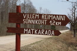
Paunas taka (Pauna rada)Kultūrvēsturiska taka (garums ~ 2 km) Tipu (Tipu) ciemā, kas iepazīstina ar vairākiem interesantiem objektiem: veco skolu (1931. g.), Hallistes upi, pirti un Paunas saimniecību, kurā dzimis viens no Igaunijas nacionālās kustības līderiem Villems Reimans (1861. – 1917.). |
 |
Estonia
KassariThe Kassari Island is the fifth largest Estonian island, and it is found to the South of the Hiiumaa Island. There are two dams between the two islands, and a road for motor vehicles has been installed atop them.
Services
150km - Distance from countries capital cityServices - recreational
Bicycle trailBike the route Käina-Orjaku-Kassari-Esiküla-Käina (22 km). 
Nature trailThe Orjaku nature trail (up to 2 km); the Sääre tirp – a 3-km hike along a rocky path on the southern end of the Kassari Island;
Nature watchingBirdwatchers will enjoy the Bay of Käina, where a colony of great cormorants and other water birds can be found. There is a bird-watching tower at Orjaku, as well as a viewing platform at the Bay of Vemla (Vaemla laht). |
 |
Estonia
LuitemaaThe word “Luitemaa” means “land of the dunes” in Estoninan. This coastline territory stretches for 13 km between Vöiste and Häädemeste with shallow waters, large coastal plains, Estonia’s highest dunes, and the Tokuse swamp (Tokuse raba). There are lots of birds here.
|
 |
Estonia
Aegna IslandAn afforested island in the Gulf of Finland, approximately 14 km to the North of Tallinn. There is a network of small roads and trails on the island. Forests: Mostly 1.1, 1.2 and 4.2. Information: www.aegna.ee. A ferry boat to the island departs from the port at Pirita. Hike around the shore of the island, where you will find all kinds of environments – dunes, sandy areas, rocky areas and places with lots of reeds (~9 km). |
 |
Estonia
Kap JumindaDer weiteste Nordpunkt der Juminda Halbinsel mit einer Raketen-Attrappe der Sowjetarmee, der alten Grabstätten, dem Juminda-Leuchtturm und einem Denkmal für die Opfern des Zweiten Weltkriegs. 69
Services
69km - Distance from countries capital city |
 |
Estonia
Perajerva meza taka (Pärajärve metsarada)Četrus kilometrus gara marķēta lokveida taka, kas ved pa lielāku meža masīvu, iepazīstina ne tikai ar augiem un dzīvniekiem, bet arī mežsaimniecības tradīcijām. Takas sākums atrodas pie nelielā Perejerves ciema, uz kuru paveras labs skats no tuvējā paugura. Pie autostāvlaukuma izveidota atpūtas un piknika vieta. |
 |
Estonia
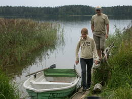
The Vilsandi National ParkThe national park was established to protect the 100 or so small islands that make up the archipelago of the local area. The largest island, the Vilsandi Island, is 6 km long and up to 2 km wide. You can rent a boat to get there, or, during appropriate conditions, you can walk across the sea and the small islands from the southern end of the Kuusnõmme peninsula.
Services
255km - Distance from countries capital cityServices - recreational
Boat tourBoat along the islands of the archipelago, but keep in mind that the Vaika Island and the Nootamaa Island are nature reserves which are closed to visitors.
Nature trailHike the route Loona-Kuusnõmme (8 km), hike around the Vilsandi Island (~12-15 km), hike the Harilaid peninsula (~10 km).
Nature watchingBird-watching from the southern end of the Vilssandi Island – the nearby Vaika Island is closed to visitors. There is a viewing tower on the N end of the Kuusnõmme peninsula. The visitor centre of the park is found at the Loona estate (Loona mõis). |
 |
Estonia
Kuranidu macibu taka (Kuuraniidu õpperada)1,7 km gara lokveida taka, kas iepazīstina ar dažādiem meža biotopiem, to iemītniekiem un meža apsaimniekošanas pamatprincipiem. Apmeklētāju ērtības nolūkā ir izveidotas koka laipas un neliels skatu tornis. 159
Services
159km - Distance from countries capital city |
 |
Estonia
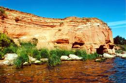
The sandstone cliffs of KallasteThis is one of the few places in the Baltic States where one can find Devonian period sandstone cliffs featuring abrasion caves, arches, etc. The cliffs are on the shores of Lake Peipsi (Peipsi järv), near Kallaste, and they are between two and four (in some cases – nine) metres high, stretching for a distance of around one km.
ServicesServices - recreational
Nature trailHike along the shores of the lake to and from the cliffs (3 km).
Nature watchingThere is a viewing tower which offers a good look at Lake Peipsi and the shoreline. For more information: www.kallaste.ee (only in Estonian). |
 |
Estonia
Kihnu islandCultural space of Kihnu (www.kultuuriruum.ee) is incorporated in the UNESCO list of Masterpieces of Oral and Intangible Heritage of Humanity, and is a quaint mix of old and modern. The local history museum displays tools, clothes, handicraft and furniture. 180
1-12
Services
180km - Distance from countries capital city
1-12 Active season months |
 |
Estonia
Mekonnu skatu tornis (Mäekonnu vaatetorn)Viens no diviem nacionālā parka skatu torņiem, kas atrodas ~ 1,5 km ziemeļos no Ehijerva ezera (Ähijärv). Tornis ir veiksmīgi „nomaskēts” nelielā priežu pudurī, tādēļ tas „nebojā” izcilo dabas un kultūrainavu, kas paveras no tā skatu platformas. Pie autostāvlaukuma ir izveidota labiekārtota atpūtas vieta. |
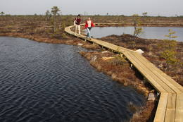 |
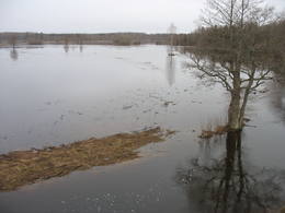
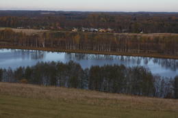
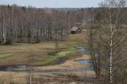
Estonia
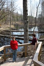
The Soomaa National ParkThe word “Soomaa” means “land of the swamps” in Estonian. There are several major swamps in this area, along with rivers, lowland meadows, wetland forests, and other biotopes that are of key importance in terms of the diversity of species. Major floods occur here in the spring, which is known by locals as the “fifth season''. The fifth season is the best time to explore the landscape of Soomaa. Services
150km - Distance from countries capital city
1-12 Active season monthsServices - recreational
Fishing
Cross-country skiingDuring the winter, there is cross-country skiing and hikes across frozen swamps. The visitor centre is in Tõramaa. For more information: www.soomaa.com (available in English).
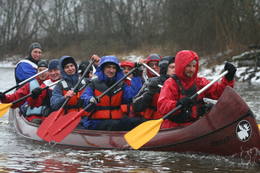
Boat tourCanoeing is possible on flooded territories and down the rivers of the park.
Nature trailWalking tours in the park
Nature trailHike the area in the presence of a guide, go “bog-shoeing”, hike the Riisa swamp trail (5 km, with watching tower), the Ignatsi trail (4.5 km, with watching tower), the Beaver information trail (3 km), the Tõramaa trail (2.5 km, with watching tower), and other trails and routes in the park.
Nature watchingYou can go on a beaver safari and look for other animals in the company of a guide. |


