
| No | Name | Description |
|---|---|---|
 |
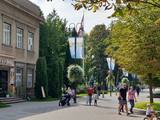
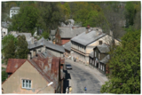
From the 6th century until the 8th century instead of the current Grobina the largest known Scandinavian trade and warrior colony in the Baltic States was located. Settlers from the inlands of Gotland and Sweden established their settlement at the hillock that was then located at the bank of the navigable Alande River. It is believed that the Cours Castle – Seeburg mentioned in the chronicles of the 9th century was located exactly here. After the loss of the order castle in the 13th century Grobina became the centre of the region. The most ancient construction of the city was formed around Lielā Street, as well as around Saules and Parka Streets. |
|
 |
Apdzīvota vieta ~ 1 km dienvidos no Daugavpils – Krāslavas (A 6) ceļa, kas pazīstama ar savu neparasto nosaukumu. Interesanti, ka vietvārds saistīts arī ar iedzīvotāju uzvārdiem, ko var redzēt tāda paša nosaukuma kapos. Ciema apkaimē pazīstams ir Lielo Muļķu svētavots, kuru gan nezinātājam ir grūti atrast, tādēļ ieteicams izmantot vietējā gida pakalpojumus, apvienojot šīs vietas izziņu ar biškopības saimniecības „Cīruļi” apskati. |
|
 |
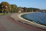
An ancient territory inhabited by Livs already since the 5th – 6th century. In 1226 Bishop Albert built a castle on the right bank of Salaca river estuary, which has not been preserved until now. Salacgriva development also (similar to Ainazi) has been associated with the establishment of the port in the turn of the 19th – 20th century. Salacgriva became an important handling and transport hubs of products manufactured in Northern Vidzeme (especially timber). During the Soviet period, in the Northern part of Salacgriva established the Fishermen Park with one of the best small town stadiums and open air stage. During that time, the products of fish processing plant "Brīvais vilnis" was well known in the territory of USSR - especially sprats. Salacgriva is one of the two places in Latvia, where the weirs are still used for lamprey fishing. |
|
 |
It is believed that at the Kezberkalnins of Limbazi has been Lemisele castle of Metsepole Liv district. It is also found in the reports that merchants travelled to this place from the sea by Svētupe and Dunezers until the 16th century. In 1223 Bishop Albert built a stone castle in Limbazi. Like Valmiera, Limbazi became the member of Hanseatic League. At the beginning of 16th century it economic role declined significantly since Svētupe and Dunezers became unusable for shipping. Between the 16th and 18th centuries, the town and its people suffered from wars, diseases and fires. As a result, the population reached its utmost fall - eight people. In the turn of 19th and 20th century and in the beginning of 20th century the economic life of the town was renewed. |
|
 |
Materials of archaeological excavations show that the Ogre river banks were inhabited by the Livs. Ogre as a larger populated area and a major resort developed after the construction of Riga-Daugavpils railway in 1861. Until the World War I about 300 cottages offered their services in Ogre, most of them were destroyed during the war. The next "major" event took place 1965 when one of the largest knitwear plants in Europe was built in Ogre, which was staffed by guest workers from Vietnam and countries. Today, Ogre has still not recovered its glory of a resort, but has become a rather exclusive site of mostly low-rise residential buildings. |
|
 |
Saldus is mentioned in the historical documents already in 1253. Until the 13th century an ancient Cours castle Salden was located here, which is also represented in the coat of arms of the town. Around the 1341 Livonian Order built a castle near the Cours hill fort, where settlement formed. Its peak of development, like the other settlements of Courland, was during the reign of Duke Jacob 1642 – 1682. 1856 is mentioned as the year of the foundation of Saldus, when restoration of town perished during the Northern War begun. At the end of the World War II a big fights took place at the town, but town remained in German-occupied part of Latvian until the May 8, 1945. Modern Saldus attracts with its activities - town days, the music festival "Saldus Saule", as well as a variety of sightseeing objects, among which A/S 'Druvas Partika" can be mentioned, where you can watch how the ice cream is made and Saldus Food Factory, where you can taste the delicious candy "Gotina" and watch the production process. |
|
 |
The largest city near the Liv Coastline, where visitors will find the Ventspils branch of the Liv Association and the Liv ensemble "Rāndalist." In nearby Tārgale are the Liv ensembles "Kāndla" and "Piški kāndla." |
|
 |
Ģipka is a village that once was the site of the first maritime school in Kurzeme. It was opened in 1869, just a few years after a similar school in Ainaži. This was a Category 2 maritime school, which trained helmsmen for long-distance trips and captains for short-distance trips. The school was moved to Mazirbe in 1894. Before the maritime school, the building housed a different kind of school, and a second floor was added in 1867 specifically for the maritime school. Today this is a residential building. During 28 years, the school trained more than 200 professional sailors, and it was of great importance in facilitating ship building in shoreline Liv villages. (Source: Roja TIC) |
|
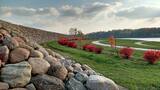 |
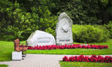
To the south of Koknese, the Destiny Garden is on an island that is surrounded by the waters of the Pļaviņas hydroelectric power plant (there is a bridge to the shore). The aim of this fundamental open-air object was to commemorate people in Latvia who suffered because of totalitarian regimes. The first work here began in 2008, and the designer of the landscape was a Japanese landscape architect, Shunmyo Masuno. Work on the garden continues, but it is already a popular tourist destination. The first permanent structure is a terrace that offers a view of the Koknese castle ruins and the local Lutheran church. This means that there will be something new each time that people visit the park. People are invited to bring rocks for this nationally important location that commemorates Latvia’s history. |
|
 |
Schon seit der früheren Zeiten – ein Platz von der militärischen und strategischen Bedeutung. Für den Schutz des Hafens von Klaipeda wurde 1866 von preussischer Militär den Bau einer Festung angefangen. Im Laufe des 2.Weltkriegs wurde die Festung in die Luft gesprängt. Die Renovierung begann 1979. |
|
 |
Pirmo reizi vēstures avotos 1253. g. šī vieta ir minēta kā kuršu apdzīvota apmetne. Laikā no 1637. – 1639. g. te uzcēla pirmās 19 kapelas – t.s. „Krusta ceļa stacijas", kas atgādināja Jeruzalemes Krusta ceļu. Kopš tā laika Žemaišu Kalvarija ir pazīstama kā nozīmīgs svētceļnieku galamērķis. Dažas no Krusta ceļa kapelām ir veidotas 17. – 18 gs., bet citas – 19. gs. Jāatceras, ka vēl pavisam nesen – Padomju laikos svētceļniekus nežēlīgi vajāja un represēja. Mūsdienās pilsētā ir izveidots 21 svētceļnieku „pieturas punkts". Te ik gadu (parasti no 2. – 12. jūlijam) notiek Žemaišu Kalvarijas katoļu draudzes svētki, kas pulcina daudz ļaužu no dažādām Eiropas valstīm. Iespaidīgā katoļu bazilika ir slavena ar Vissvētākās Jaunavas Marijas Katoļu Ģimeņu Karalienes gleznu, kas 17. gs. atvesta no Romas. Tai piedēvē brīnumdarītājas spējas. Interesants ir pilsētas ielu tīklojums, kas atgādina 9. – 13. gs. apdzīvotas vietas ielu plānojumu. Noteikti apskatāms iespaidīgais Žemaišu Kalvarijas pilskalns, kas slejas mazās Varduvas (Varduva) upītes krastā. |
|
 |
Aizputes pilsdrupas, akmens tilts pār Tebru, Jaunā pilsmuiža, ūdensdzirnavas un Sv. Jāņa luterāņu baznīca, kā arī 19. gs. beigās celtās koka ēkas starp Jāņa, Katoļu un Atmodas ielu veido neparastu pilsētbūvniecības kompleksu, kam piešķirts kultūras pieminekļa statuss. Staigājot pa vēsturisko centru, uzmanība jāpievērš ēku durvīm un to vērtnēm, logu ailēm, balkonu margām u.c. elementiem. |
|
 |
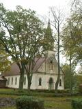
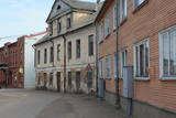
Valdemārpils is a small and quiet town along the shore of Lake Sasmaka. A village of craftsmen and merchants was established on the land of the Sasmaka Estate in the 17th century. There were quite a few Jewish merchants and craftsmen in towns in Kurzeme during the mid-19th century, and Sasmaka was known as their capital city. The city was named Valdemārpils in 1926. Its historical 19th century centre is a monument to urban construction. The town has a Lutheran church, an Orthodox church, a former synagogue, a monument to Krišjānis Valdemārs, and an outstanding linden tree. |
|
 |
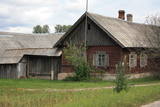
This village appears in historical documents from 1310. A census in 1582 and 1583 recorded eight farms in the village, while a 1731 census conducted by the Dundaga Estate found only three. In 1826, each farm had 16 or 17 people, with some 60 in total. A census in 1935 showed that all 49 Livonians in Saunags spoke the Lithuanian language, but only 11 of them spoke the language at home. There was a store that was owned by Kārlis Tilmanis, who also owned a factory where sprats were salted. Also born in Saunags was the seafaring captain Arvīds Ludeviks (1912-1996). In May 1945, he captained a tugboat, the Rota, in an attempt to bring Latvian refugees to Sweden. The ship was detained, and the captain was sent to Siberia. Another seafaring captain from Saunags was Visvaldis Feldmanis (1938-2017). |
|
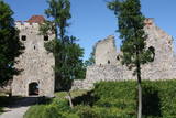 |
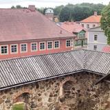
Exploring of Sigulda can be started with a visit to Sigulda castle ruins. The construction of the castle was begun by the Knights of the Sword Order in 1207, but in 1236 it was rebuilt for the needs of the Livonian Order. Sigulda castle suffered much from the wars in the second half of the 16th century and in the beginning of 17th century. During the Northern War, it is burned down and is no more restored. Today south-western building of the convent and the tower of the main gate, behind which is the inner forefront of the castle with open air stage, which offers impressive views over the Gauja valley. Currently the reconstruction of castle ruins is in progress. Construction of New castle (owner - Prince Kropotkin) in the South of the Sigulda took place from the 1878 until 1881. From 1923 - 1940 the building was the Palace of Writers, but during the Soviet years - Cardiology sanatorium. Since 2003 Sigulda district council is located there. The manor complex includes wooden house (middle of 19th century), which was Kropotkin's family home, barn (turn of the 18th - 19th century), gardener's house (19th century) and a stone fencing (19th century.) If we make our way from New Castle in a north-eastern direction, after almost 2 km we will reach Vejupite ravine. There you can see the shallow (3.6 m) but high (6.1 m) in Peter's Cave and deep Pucu ravine with Krauklupite. At the conjunction of ravines of both streams rises a Satezele hill fort (plateau 90 x 75 m), where in the beginning of 13th century was the oak castle of Liv land chief (eldest) - Dabrelis. Near can be found Krauklu gorge - ravine of Vejupite left bank, with 11 m high sandstone walls and 5.2 m deep Krauklu cave. At the conjunction of Vejupite ravine and Gauja valley columns Paradise (Gleznotaju) Hill - a very picturesque place, painted and photographed since old times! The Paradise Hill can be reached with a electric vehicle. In the west part of Sigulda is located Ferris wheel (works during the summer) and Air cableway (streetcar) - the only this type of vehicle in Baltics (built in the 1969). Its self-supporting cable extends in 1060 m length and without any support joins the Gauja River valley banks between Sigulda and Krimulda ~ 40 m above Gauja River. Here you can enjoy excellent views! In the south-western part of Sigulda one can walk to mighty Beites precipice, which is split by the deep ravine of stream. On the west side of the ravine lies Keizarskats, which is located ~ 67 m above the Gauja level and offers good views of Krimulda and Turaida castle. Sight place was arranged here already in the 1862 when Russian Tsar Alexander II visited Sigulda. In the eastern part of the ravine wooden Keizarkrēsls (Emperor Stool) is located. |
|
 |
Pavilosta is a comparatively new city that has formed at the mouth of the Saka River in the Baltic Sea. True is the fact that in the medieval times the harbour of sea ships was located 6 km from the sea – at the junction of the Tebra and the Durbe Rivers. Important period in the life of the harbour was during the ruling of Duke Jacob, when sea ships arrived here. As a result of the Polish-Swedish war the Saka harbour had to be closed. The harbour that's visible nowadays in the mouth of the Saka River was formed in the middle of the 19th century at the so called Akagals fishermen village. In 1878 the river mouth was excavated and piers were built. Here two-masted ships were built. The World Wars destroyed the fleet, but the fishery traditions remained alive. In 1991 the populated area acquired the status of a city. Nowadays Pavilsota is a popular target for yachtsmen and windsurfers, as well as summer recreation place. Yachtsmen are awaited at the yacht harbour. |
|
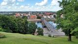 |
The second biggest city in Lithuania and from 1920 – 1939 - a temporary capital. The Old Town, The Town Hall (16th century), St. Peter and Pavil cathedral - basilica (15th century), Thunder building (15th century), Laisves alley, Ciurlionis Art and Devil Museum. |
|
 |
The most populated place in The Curonian Spit - old curonian village - Nida. Until 19th century Nida's citizens were mainly fishermen. Later it became a popular resort. Like other villages here Nida has been "moved" because of "wandering dunes". There are a lot of museums to see. During tourism season there is around ~ 200 000 – 300 000 tourists here.
|
|
 |
The Old Town of Kandava is located around the old Market Square and dates back to 1881, after a fire in the town. The urban environment in Kandava is made up of farms with various buildings, closed yards, passageways and walls made of fieldstones. These can be seen in Talsu Street and Sabiles Street. Uncommon for Latvia is Lielā Street. At the foot of the Bruņinieku Castle Hill is a model of the Castle of the Livonian Order that was created in 2010. |
|
 |
Vom 18. Jh wurde die Stadt ein russischer Marinestützpunkt. Von 1962 bis 1994 war Paldiski ein Übungszentrum für atomare U-Boote der Sowjetischen Marine mit zwei auf dem Festland befindlichen Kernreaktoren (ung. 16.000 Beschäftigte) und eine "geschlossene Stadt". |
|
