
| No | Name | Description |
|---|---|---|
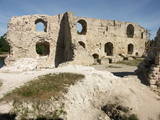 |
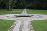
The ruins of the Koknese Castle are found where the Daugava and Pērse rivers flow together. The castle, which is on a floodplain, was built for the bishopric of Rīga in 1209, and it replaced an ancient Latvian castle that was made of wood. The castle was blown up by Saxon forces in 1701. A visitors centre is near the ruins, and there you can carve a Medieval coin or rent a boat to sail down the Daugava. Make sure to stroll through the Koknese park, which is alongside the ruins. |
|
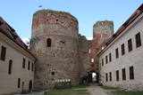 |
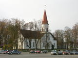
Bauska's name in historical sources for the first time is mentioned in 1443. This is the time when on the peninsula between Musa and Memel confluence construction of last Livonian Order castle on the present-day territory of Latvia was begun. At the castle – in Ķirbaksalā populated area so-called Vairogmiests developed. During the 17th century rapid boom of the town was observed. Here were working goldsmiths, silversmiths, carpenters, potters, shoemakers and other craftsmen. In later centuries the city suffered from wars, plague and Napoleon army. Today Bauska old town with reconstructed City Hall and the restored Bauska Castle is one of the most interesting Latvian historical town centres. Bauska is known for its annual events - Ancient Music Festival, Bauska town festival, country music festivals, and other events. |
|
 |
On the right bank of the River Pēterupe is one of the historical areas of Saulkrasti – Pēterupe Village. It is believed that the village began to form around a chapel during the so-called Swedish or Catholic times. The chapel was named after the Apostle St. Peter, and therefore the river and the village also carries his name. Pēterupe Village can be considered the oldest village in the Saulkrasti region. The oldest witnesses of the origin of Pēterupe Village are: Rectory, Pēterupe Evangelical Lutheran Church, Outpatient Clinic and the wooden buildings in the old village centre. |
|
 |
A long village stretching along both banks of the Lūžņa River. In 1937, there were 36 houses and two boat piers here. During the 1860s, ships were built here, but during the Soviet occupation, there were military bases there. During the 1930s, the village was visited several times by the Finnish linguist Lauri Ketunen and Estonian student Oskar Lorits. They were working on a Livonian dictionary. Another resident of Lūžņa was the first Livonian artist, Jānis Belte (1893-1946). The "Dēliņi" fisherman's homestead has been transferred to the Latvian Ethnographic Open-Air Museum and can be seen there. |
|
 |
A small settlement on the banks of the River Daugava, between Aizkraukle and Jaunjelgava. Skriveru region is associated with the life and work of popular Latvian author A. Upitis. Near Skriveri lies the oldest arboretum in Latvia. Its establishment in 1891 was started by the owner of Skriveru manor Maximilian von Siverss. In the park there are about 400 plant species, varieties and forms. One of the finest views of the Daugava will open from the so-called Krauklu Mountains – steep upper part of the right riverbank, which is an ancient hill fort. |
|
 |
Madona is probably the only town in Latvia, in whose area a lake settlement was located around the 9th century. Its residues are preserved in the northern part of Salas Lake (Baznicezers) under water. Until the end of 19th century, a small estate with the same name (Madona) was located in place, where present town is located, Latvians called the place Bizi. In 1898 construction of narrow gauge railway between Stukmani (Plavinas) and Valka was started. The development of railway helped the development of the town. Today Madona is well maintained Vidzeme town with its own charm typical for small town. Interestingly that it can also be considered as one of the most highly placed towns in relief of Latvia. |
|
 |
Ventspils Vecpilsētas vēsturiskais centrs. Nelielā Rātslaukuma (40 x 60 m) rietumu malā atrodas Starptautiskā rakstnieku un tulkotāju māja, kas ierīkota 18. gs. dzīvojamā ēkā ar baroka un klasicisma iezīmēm (19. gs. vidū te atradās pilsētas Rātsnams), bet austrumu malā – vēlīnā klasicisma stilā celtā evaņģēliski luteriskā Nikolaja baznīca. Iepretim baznīcai atrodas modernā stilā pārbūvētā Ventspils Galvenā bibliotēka un Digitālais centrs, kas ierīkots greznā 19. gs. savrupmājā. |
|
 |
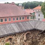
The history of Cēsis begins at the Riekstu hill, which is 18 m high and the surrounding area. There was a wooden castle built by the Vendian tribe that stood there from the 11th to the 13th century. The hill is in the central part of the castle’s park, and it offers a fine view of the park, a pond and the ruins of the Cēsis Castle. A long staircase leads to the hill. The Cēsis Castle was built in the early 13th century as the residence of masters of the Livonian Order, and it was one of the most fortified forts in the Baltic region. Alongside is the New Cēsis Castle, which was built in 1777 in a place where gate fortifications had been before. The building houses the Cēsis Museum of History and Art, and an annex contains the Castle Visitor Centre and the Cēsis Tourism Information Centre. From the tower of the castle, we get a good view of the castle ruins, St John’s Lutheran Church and the northern stretches of the city. Opposite the new castle is the stable of the Cēsis Castle Estate and a wheelhouse (both from the first half of the 19th century). Today these house the Cēsis Exhibition Hall. Other buildings include a granary, a hut for coachmen and an old brewery. On the other side of the street is the romantic May park, which was installed during the 1830s. Streets in Cēsis include Lielā Katrīna, Mazā Katrīna, Mazā Kalēju, Kalēju and Lielā Līvu streets and Līvu square with wooden buildings from the late 18th and early 19th century. Torņa Street stretches along the walls of the Medieval castle. Outside the church is a sculpture, “As the Centuries Pass By,” and legend has it that anyone who rubs the lantern of the Old Time Man can see the future. One of the most impressive buildings in Cēsis is St John’s Lutheran Church, which was built in the late 13th century by the Livonian Order. The Roman-style three-segment basilica has elements of Gothic design and a 65 m steeple that was installed in 1853. The building was reconstructed several times during the 20th century and contains grave plaques relates to masters of the Livonian Order and local bishops. The pulpit dates back to 1748, the oak altar was manufactured in 1858, and the altar painting “Crucified One” was painted in 1862. The windows of the altar part of the church contain artistically valuable stained glass. The organ was manufactured in 1907 by the E.F. Walker firm, and it is one of the best concert organs in Latvia. The solar clock with the number 1744 is in the south-wester corner of the church. It is worth scaling the viewing tower of the church. At its foot is Rose Square, which was a market square from the mid-13th century until 1927 and was restored in 2008. This is the central square in the city. During the Middle Ages, a punishment pole and the city well were here. Rīgas Street has been the main street in the old part of the city from the very start, and here we find most of the architecturally distinguished buildings from the 18th and 19th century – the former city hall, the Fābers house and the Princess house. At one end of the street is Liv Square, where there a church, cemetery and the Rīga gate in the city’s walls existed in the 13th century. Today the square is decorated by a lighted fountain at a place where a well was found in the 13th century. On the other end of the street we find a reconstruction of the foundations of the Rauna gate from the 14th and 15th century, offering a good look at Medieval walls and the size and strength of the gates. It is commonly claimed that the national flag of Latvia was born in Cēsis, but it must be emphasised that the flag that is mentioned in chronicles was designed in Cēsis in 1279 as the ideological prototype of the current Latvian flag, while the story of the first national flag actually comes from Valmiera, where it was sewn in 1916. |
|
 |
Until 13th century, Smiltene region was a part of Talava country, inhabited by Latgalians. After Crusaders invasion it was won by the Archbishop of Riga, and he built a stone castle on the steep river bank of Abuls in 1370. The following wars and epidemics did not spare the development of settlement, nor the people. Present shape of the town began to emerge in 19th century along with the vigorous activities of owner of Smiltene manor first Lieven. Until the World War I, wood working factory, hydroelectric power plant (established in 1901, first in the Baltics), and other companies were operating in Smiltene. In 1944 when the German forces retreated, much of the Smiltene historical buildings were destroyed in the fire. |
|
 |
It is believed that at the Kezberkalnins of Limbazi has been Lemisele castle of Metsepole Liv district. It is also found in the reports that merchants travelled to this place from the sea by Svētupe and Dunezers until the 16th century. In 1223 Bishop Albert built a stone castle in Limbazi. Like Valmiera, Limbazi became the member of Hanseatic League. At the beginning of 16th century it economic role declined significantly since Svētupe and Dunezers became unusable for shipping. Between the 16th and 18th centuries, the town and its people suffered from wars, diseases and fires. As a result, the population reached its utmost fall - eight people. In the turn of 19th and 20th century and in the beginning of 20th century the economic life of the town was renewed. |
|
 |
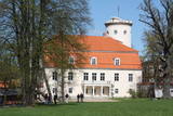
Located in the northern part of Valmiera, the Valmiermuiža Estate mansion (Neo-Baroque Style) was built between 1764 and 1771 by Prince August Friedrich of Schleswig, Holstein and Soderburg. Over the course of time it has been owned by other people. According to modern evidence, the mansion was a one-story building with a Baroque tower and a two-story addition in the early 20th century, which made it appropriate as a summer home and hunting lodge. The building burned down in 1918. Two years later, Valmiermuiža became a prison camp for captured soldiers. Later the addition to the mansion was restored and used as an elementary school. In 1936, the building became a prison, and it was once again a prison camp for captured soldiers during World War II. Later the building burned down again, and the ruins were removed. Still surviving is the Valmiermuiža tower, with ceiling paintings that are a cultural monument, as is the surrounding park. The Valmiermuiža brewery is alongside the historical monument, thus providing second wind for the whole region. |
|
 |
Saldus is mentioned in the historical documents already in 1253. Until the 13th century an ancient Cours castle Salden was located here, which is also represented in the coat of arms of the town. Around the 1341 Livonian Order built a castle near the Cours hill fort, where settlement formed. Its peak of development, like the other settlements of Courland, was during the reign of Duke Jacob 1642 – 1682. 1856 is mentioned as the year of the foundation of Saldus, when restoration of town perished during the Northern War begun. At the end of the World War II a big fights took place at the town, but town remained in German-occupied part of Latvian until the May 8, 1945. Modern Saldus attracts with its activities - town days, the music festival "Saldus Saule", as well as a variety of sightseeing objects, among which A/S 'Druvas Partika" can be mentioned, where you can watch how the ice cream is made and Saldus Food Factory, where you can taste the delicious candy "Gotina" and watch the production process. |
|
 |
Pilsētas rajons dienvidos no Ventas grīvas, kura mūsdienās redzamā mazstāvu koka apbūve sāka veidoties 19. gs. vidū. Ostgala pirmsākumi meklējami 1836. g., kad Krievijas valdība, solot priekšrocības, aicināja apkārtnes zvejniekus apdzīvot smilšaino un kustīgo kāpu pārņemto piekrastes daļu. Ostgals ir atzīts par valsts nozīmes pilsētbūvniecības pieminekli. |
|
 |
The Lutheran Church of Krimulda is considered one of the oldest churches in Latvia. It was originally built in the 13th century, soon after the conquest of Kubesele and later rebuilt many times. Near the church a meditation labyrinth "Lily Flower" is set up. When Liv chief Kaupo fell during the battle at Viljandi in 1217, according to the legend, the ash was buried at the church. A small hill adjacent to Runtinupite (Runtins) is popularly known as a grave site of Kaupo, at its right bank is located ~7 m long, artificially dug Kubesele or Runtin cave. On the left bank of Runtinupite columns the Kubesele hill fort. Kubesele nature trail starts at the church. This trail leads to the Gauja River, where the Great (Runtina) stone lies. Here can be seen anchor pads installed by Gauja raftsmen. Krimulda medieval castle (4 km east of Krimulda Church) was built the second half of the 13th century in the place where the right bank of Gauja valley is split by deep ravine of Vikmeste. Castle (residence of Riga dome capitol - Riga's Archbishop Council) was an imposing building, whose big inner yard was included by 1.5 m thick defensive wall. In 1601, while retreating, Swedish military leader Heinrich Lieven blasted Krimulda castle. Now at the hill fort, grown with the forest a small castle ruins can be seen. Nearby is located air cableway and starts Krimulda mountain road. Located nearby Krimulda manor was first mentioned in writings in the 15th century. Present manor castle was built in the 19th century in neoclassical style (owner - First Lieven). During the twenties of the 20th century, the castle after its alienation became a property of the Latvian Red Cross, which established here children's sanatorium. Nowadays the castle houses rehabilitation hospital "Krimulda", but from the farm buildings, manor stables, barn, servant, manager houses and the so-called Swiss Cottage and Park have been preserved. Thematic tours are offered here. If we go down the Gauja by boat, then we will be able to take a close look at about 15 m high Velnalas cliffs. They can be well seen also from the opposite - left bank of Gauja (resting place is established). In the middle of the cliff about 19 m deep and 4.7 m high Krimulda Velnala cave is located. If we go from the Velnala cave cliffs along the lower part of the right bank of Gauja in Turaida direction, you will see Pikenes cliff, rich with sandstone outcrops. At its foot ~ 1 km long Pikenes beaver trail is established. The Little Devil's Cave (5 m long) is on the side of the trail, with the Gudribas (Wisdom) spring that springs out of the cave, as well as Aunapieres cave which is the same length as Devils cave. Small oxbow lakes also can be seen. |
|
 |
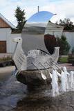
Old Town Square is the city’s historic centre. It was here, on February 12, 1670, that Duke Jacob of the Duchy of Courland proclaimed the establishment of a town. During the early 20th century, the square was covered in paving stones, and the city market was held there. On the sites of the square are the People’s Centre, the Unitarian Church and a tourism information centre. In the square are a water pump, an enormous scale, and a sculpture of a cougar, which is the symbol of Jēkabpils. From here you can tour the historical centre of Jēkabpils with its narrow streets and low-story buildings. |
|
|
|
This village is at the place where the Irbe (Dižirve, Īra) River flows into the sea, and it is on both shores of the river (sea side and land side). The name of Irbe was recorded for the first time in a 1310 border agreement between the bishop of Kurzeme and the Rīga Dome Capitol. The name of Lielirbe (Irvemūnde) was recorded for the first time in a document from an arbitration court in 1387. At the end of the 19th century, the small port at Lielirbe was an active centre for the sale and transport of timber materials. In the late 19th and early 20th centuries, the largest number of sailing ships among villages on the western shore of Kurzeme was built there. In 1939, the village had some 300 residents, more than 70 houses and a Baptist church which is now at the Ventspils Open Air Museum. A narrow-gauge railroad passed through the village, which had a post and telegraph office, two grocery stores, an elementary school, a choir and a brass band. Lielirbe was one of the largest villages to disappear after World War II. Cultural historian Valda Marija Šuvcāne (1923-2007) was born in Lielirbe, and her daughter, Baiba Šuvcāne, is continuing her mother's work by writing important papers about life along the Livonian coastline. By 2019, a bridge is to be reinstalled across the Irbe River. |
|
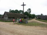 |
Ein der ethnografischen Dörfer in Dzūkija mit Holzgebäuden und Kruzifix. |
|
 |
Vēstures avotos pirmoreiz minēta 1483. g. Pilsētas uzplaukums bija vērojams pēc dzelzceļa uzbūvēšanas 19. gs. beigās, kad barons Korfs sadalīja un iznomāja apbūvei muižas zemi. Pilsētas tiesības Priekule ieguva 1928. g. Pilsēta smagi cieta 2. pasaules kara pēdējos mēnešos, - t.s. Kurzemes katla laikā, kuru laikā tika sagrautas 410 no 450 ēkām. Mūsdienās tā ir neliela pilsētiņa ar mazstāvu apbūvi un nesteidzīgu dzīves ritmu. |
|
 |
Arī 18. novembra laukums. Tas sācis veidoties 18. gadsimtā kā tirgus laukums. Tā dominantes bija 1752. g. celtais rātsnams (nav saglabājies) un aptieka, kas šajā ēkā darbojas no 1810. g. līdz pat mūsdienām. 2010. gadā laukumā izveidota strūklaka, kam ir pilsētas ģerboņa forma. |
|
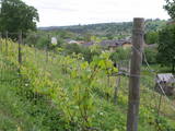 |
Already in the 10th century, an ancient village was located at the Sabile hill fort. After the division of Course land, Sabile was won by the Livonian Order, which built a stone castle (not preserved) here. Sabile is first time mentioned in written sources in 1253. During the 15th century an urban area started to develop at the castle. Town right was awarded to Sabile in 1917. Today Sabile is a small town, surrounded by many notable monuments. Roma culture is an integral part of Sabile and therefore, Sabile is also known as the Latvian capital city of Roma. Sabile has long been known for its wine-growing and oenological traditions, which have been reborn and enjoyable during the Sabile wine festival. |
|
