
| No | Name | Description |
|---|---|---|
 |
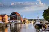
The most populated place in The Curonian Spit - old curonian village - Nida. Until 19th century Nida's citizens were mainly fishermen. Later it became a popular resort. Like other villages here Nida has been "moved" because of "wandering dunes". There are a lot of museums to see. During tourism season there is around ~ 200 000 – 300 000 tourists here.
|
|
 |
The historical centre of Talsi, which is known as the town of nine hillocks. The historical construction around Baznīckalns hill, Lake Talsi and Lake Vilkmuiža mostly dates back to the 19th century. Lielā Street is particularly beautiful with its low-rise buildings (two or three floors and ridged roofs). There are beautiful views from the area around Lake Talsi and Ķēniņkalns hill. |
|
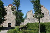 |
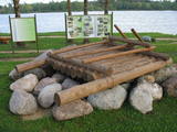
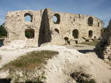
Exploring of Sigulda can be started with a visit to Sigulda castle ruins. The construction of the castle was begun by the Knights of the Sword Order in 1207, but in 1236 it was rebuilt for the needs of the Livonian Order. Sigulda castle suffered much from the wars in the second half of the 16th century and in the beginning of 17th century. During the Northern War, it is burned down and is no more restored. Today south-western building of the convent and the tower of the main gate, behind which is the inner forefront of the castle with open air stage, which offers impressive views over the Gauja valley. Currently the reconstruction of castle ruins is in progress. Construction of New castle (owner - Prince Kropotkin) in the South of the Sigulda took place from the 1878 until 1881. From 1923 - 1940 the building was the Palace of Writers, but during the Soviet years - Cardiology sanatorium. Since 2003 Sigulda district council is located there. The manor complex includes wooden house (middle of 19th century), which was Kropotkin's family home, barn (turn of the 18th - 19th century), gardener's house (19th century) and a stone fencing (19th century.) If we make our way from New Castle in a north-eastern direction, after almost 2 km we will reach Vejupite ravine. There you can see the shallow (3.6 m) but high (6.1 m) in Peter's Cave and deep Pucu ravine with Krauklupite. At the conjunction of ravines of both streams rises a Satezele hill fort (plateau 90 x 75 m), where in the beginning of 13th century was the oak castle of Liv land chief (eldest) - Dabrelis. Near can be found Krauklu gorge - ravine of Vejupite left bank, with 11 m high sandstone walls and 5.2 m deep Krauklu cave. At the conjunction of Vejupite ravine and Gauja valley columns Paradise (Gleznotaju) Hill - a very picturesque place, painted and photographed since old times! The Paradise Hill can be reached with a electric vehicle. In the west part of Sigulda is located Ferris wheel (works during the summer) and Air cableway (streetcar) - the only this type of vehicle in Baltics (built in the 1969). Its self-supporting cable extends in 1060 m length and without any support joins the Gauja River valley banks between Sigulda and Krimulda ~ 40 m above Gauja River. Here you can enjoy excellent views! In the south-western part of Sigulda one can walk to mighty Beites precipice, which is split by the deep ravine of stream. On the west side of the ravine lies Keizarskats, which is located ~ 67 m above the Gauja level and offers good views of Krimulda and Turaida castle. Sight place was arranged here already in the 1862 when Russian Tsar Alexander II visited Sigulda. In the eastern part of the ravine wooden Keizarkrēsls (Emperor Stool) is located. |
|
 |
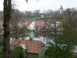
For the first time Valmiera is mentioned in the historical sources in 1323. Until the 13th century this place was in the composition of Talava, inhabited by Latgalians. Construction of Valmiera medieval castle began in the beginning of the 13th century, but in 1283, between the Gauja River and Rate River towered church. Location near to the Tartu-Pskov and Novgorod trade routes greatly facilitated the economic development of the populated area. During the 14th-16th century Valmiera was a part of the Hanseatic League. It suffered greatly from wars, epidemics and fires in 16th to 18th century. In the second half of the 19th century the economic boom started again. It was also facilitated by the building of wooden bridge across the Gauja in 1866 and Riga-Pskov railway opened in 1899. Historic centre is destroyed in 1944. During post-war years, large industrial companies such as - Valmiera glass fiber factory (to this day) are opeating in the town. Today, Valmiera is economic, educational and sports centre of Vidzeme. |
|
 |
Plavinas and Stukmani region was inhabited already in the third century. During the Polish-Swedish War (1600-1629) at estuary of Aivekste in the Daugava River the Swedish war camp was formed, from which are preserved fortifications - bastions. They are one of the most impressive military formations of this kind in Latvia. Plavinas as a larger populated area started to develop in the nineties of the 19th century and in the beginning of 20th century after the construction of railway. Today Plavinas are more commonly known with dolomite production sites and spring flood area. |
|
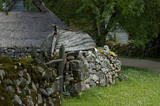 |
Koguva village on Muhu island is an outstanding example of peasant architecture in Estonia. Farmsteads with dry stone walls are protected as an architectural monument. The museum complex comprises a wealthy seaside farm Tooma (Juhan Smuul, an Estonian author, was born here) with all its outbuildings and tools, a former village school and a textile exhibition. |
|
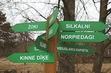 |
is seen as the newest village along the Livonian coastline. It was established during the 17th century. Košrags had 78 residents in 1826. The first reading school for Livonian children in the Dundaga seashore villages was opened at the Žoki homestead in 1832. One of the teachers was Nika Polmanis, who was the first Livonian to have completed a professional education. He also translated the Gospel of Matthew into the Eastern Livonian dialect. Košrags had a windmill, water mill and boat building facility. During the spring, job seekers from Saaremaa stopped here. A port was installed in 1932, and a breakwater to collect sea fertiliser followed in 1938. During the 1930s, Košrags was regularly visited by Finnish and Estonian linguists to study the folklore of the Livonians. The Norpiedagi homestead was built by Livonian activist Didriķis Volganskis (1884-1968). His son, Livonian cultural worker and pastor (in Finland) Edgars Vālgamā (Volganskis, 1912-2003) was born there. He translated the Andrejs Pumpurs epic "Lāčplēsis" into Finnish. Košrags today is a cultural monument of national importance. |
|
 |
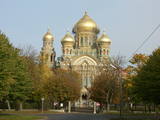
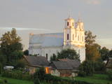
The Capital of Saaremaa island. Popular resort. The Town Hall is built in the style of Baroque. |
|
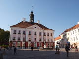 |
Formed on the left side of river Emajõgi, in the valley of Doma Hill. The centre of The Old Town of Tartu is Town Hall Square with Town Hall and the fountain "The Kiss of the Students" (symbol of the city). |
|
 |
The city of wind, amber and musicians. In the literature sources Liepaja was mentioned for the first time in 1253. The city strived as a trade harbour already at the end of the 16th century. Especially important was the ruling period of Kurzeme Dukes Jacob and Friedrich, when the export and import of Lithuania and Kurzeme goods was provided through Liepaja harbour. Instead of the Līva River that was filled with dune sand a channel was excavated and wharf was formed. The growth of the city continued in the 18th century also after the Northern War and the plague epidemic. When in 1795 Kurzeme was added to the Russian Empire, as one of the most important western harbours of the Empire the harbour of Liepaja developed even more rapidly. From the end of the 18th century until the 19th century Liepaja also became a popular recreation place for the aristocrats of Petersburg. At the end of the 19th century the construction works of War Port and fortress begun. The city became a military strategic place. It suffered hard during World War II. In 1967 the sea trade harbour terminated its operation in Liepaja and Liepaja became a closed city where the War Port was "a city within a city". Today the War Port and its offer is one of the top tourism spots in Latvia. |
|
 |
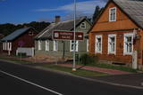
Smarde is an ancient place, mentioned in the 13th century documents. Today it is a small village with railway station and shops. Northeast of Smārde - former peat extraction places are located in Smārde marsh. During World War I the front line was near Smārde, the vicinity of which is witnessed by the memorial sites. |
|
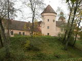 |
Every traveller in Latvia relates the name of Edole to Edole Castle. The beginning of it dates back to the middle of the 13th century, but the outbuildings of it were constructed in the 16th and 19th centuries, when patio was formed. During reconstruction of the castle implemented in the 30ies of the 19th century the facades of the castle acquired their current – Neo-Gothic appearance. From the16th century until 1920ies Edole Castle was located within the property of a baron family. In 1905 during rebellions it was burnt down, but in 1907 it was reconstructed. Many legends and ghost stories are told about Edole Castle. |
|
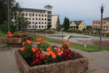 |
Madonas centrālais laukums, kas vēl 20. gs. sākumā bija tirgus laukums. Pēc apjomīgās restaurācijas tas ir kļuvis par ievērības cienīgu pilsētvides objektu. Laukuma ziemeļu pusē atrodas pilsētas un novada pašvaldība un Madonas novada TIC. |
|
 |
The central part of the town of Krāslava is an historical monument because its low-story and beautiful wooden buildings. The best views of the historical centre relate to the carp park near the Adamova trail, the Karņicskis hill, the bridge across the Daugava (Prospekta Street), and the Priedaine viewing tower on the left bank of the Daugava River. |
|
 |
The largest town in South-Eastern Latvia is on the banks of the Daugava River, which is the border between Latvia and Belarus at this location. The border runs down the middle of the river. Piedruja has two parts – Piedruja and Aleksandrova, which are separated by a central street (the V 631 road). Piedruja emerged from the Druja town that was on the left bank of the Daugava. During the 17th century, the two parts were owned by the Stapekha dynasty of Lithuanian aristocrats. It is worth strolling through the town, because the low-level wooden houses are reminiscent of buildings that are exhibited in open-air ethnographic museums. Piedruja is neat and tidy, with two churches and the Daugava rock that are part of a local hiking trails. Aleksandrova has a tourist accommodation, “Piedruja,” which offers special soirées in the Lettigalian, Russian and Belarusian style. Please be aware that you need a temporary permit to enter the border zone. The Border Guard facility is in Piedruja and at a place where there was a Daugava crossing point comparatively recently. |
|
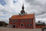 |
In 1615, Courlandian Duke Friedrich Kettler (1569-1642) allowed Bauska to build a new city hall. At the beginning of the 17th century, Market Square in Bauska featured the largest city hall in the entire duchy. A lack of money led to the dismantling of the hall’s tower in 1852 and its second floor in 1871. A new city hall was built in 2011, and now Bauska can be proud of a new and outstanding tourist destination that can also be entered. The restored city hall offers a chance for people to weigh themselves and measure their height with old-time measurements. Each person who does so receives a certificate to attest to his or her height and weight. |
|
 |
Materials of archaeological excavations show that the Ogre river banks were inhabited by the Livs. Ogre as a larger populated area and a major resort developed after the construction of Riga-Daugavpils railway in 1861. Until the World War I about 300 cottages offered their services in Ogre, most of them were destroyed during the war. The next "major" event took place 1965 when one of the largest knitwear plants in Europe was built in Ogre, which was staffed by guest workers from Vietnam and countries. Today, Ogre has still not recovered its glory of a resort, but has become a rather exclusive site of mostly low-rise residential buildings. |
|
 |
The former Memele. The only port city with a old town in Lithuania. |
|
 |
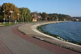
The largest town in the region dates back to the 19th century, when three local fishing villages – Neibāde, Pēterupe and Katrīnbāde – became a popular location for leisure and swimming. This led to the construction of many summer homes, and the development of the spa was facilitated by the opening of a rail line between Rīga and Saulkrasti in 1905. New spas and restaurants were opened, and the spa infrastructure was developed. During the summer there were various entertainments, including balls and concerts featuring orchestras from Rīga. Also facilitating the development of the spa was a road and railroad line between Rīga and Saulkrasti that were installed during the 1930s. During the Soviet occupation, leisure homes, sanatoriums and new summer homes were built in Saulkrasti, which was given the status of a city. Today Saulkrasti is attractive because of its white sand beach, as well as various annual events, the Saulriets trail, the White Dune, the unique bicycle museum, Sea Park, the “Centrs” swimming facility, Sun Square, etc. |
|
 |
The ruins of the Koknese Castle are found where the Daugava and Pērse rivers flow together. The castle, which is on a floodplain, was built for the bishopric of Rīga in 1209, and it replaced an ancient Latvian castle that was made of wood. The castle was blown up by Saxon forces in 1701. A visitors centre is near the ruins, and there you can carve a Medieval coin or rent a boat to sail down the Daugava. Make sure to stroll through the Koknese park, which is alongside the ruins. |
|
