
| No | Name | Description |
|---|---|---|
 |
Baltijā lielākā keramikas fabrika. Tūristu grupām piedāvā ekskursiju pa ražotni. Blakus atrodas veikals, kurā var iegādāties keramikas izstrādājumus – gan praktiskas lietas, gan interjera priekšmetus un suvenīrus. |
|
 |
The Rāmkalni recreation park is located on the side of the Murjāņi-Valka highway (A3), in the Gauja valley. It offers skiing in winter and cycling, boating, and tobogganing in summer. The restaurant and bistro serves both Latvian and Western European cuisine. Various countryside goods can be purchased in the shop. |
|
 |
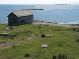
This village appears in historical documents from 1310. A census in 1582 and 1583 recorded eight farms in the village, while a 1731 census conducted by the Dundaga Estate found only three. In 1826, each farm had 16 or 17 people, with some 60 in total. A census in 1935 showed that all 49 Livonians in Saunags spoke the Lithuanian language, but only 11 of them spoke the language at home. There was a store that was owned by Kārlis Tilmanis, who also owned a factory where sprats were salted. Also born in Saunags was the seafaring captain Arvīds Ludeviks (1912-1996). In May 1945, he captained a tugboat, the Rota, in an attempt to bring Latvian refugees to Sweden. The ship was detained, and the captain was sent to Siberia. Another seafaring captain from Saunags was Visvaldis Feldmanis (1938-2017). |
|
 |
Die größte Bernsteinausstellung im Baltikum (seit 1963) mit Bernsteineinschlüssen. Ist die Bedeutung des Bernsteins in der Geschichte des baltischen Völkern wiedergespiegelt. Das Museum ist in einem dem Grafen Tyszkiewicz (1865 – 1932) gehörteten Schloss (gebaut 1897) eingerichtet. |
|
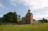 |
Pühtittsa Convent at Kuremäe was established in 1891 and is the only operating Russian Orthodox nunnery in Estonia. Centuries ago there was a sacred grove on Kuremäe hill and a sacrificial spring at its foot, the spring is considered “holy“ for its curative powers. The convent compound is open to visitors; guided tours run by nuns can be booked to learn more about the daily life of convent residents. |
|
 |
The bakery offers more than 50 different types of bread products. The “Arona” rye bread has been awarded the “Zaļā karotīte” certificate of conformity. Products awarded with the “Bordo karotīte” certificate: Rye bread, Sweet and sour bread, Latgale tin loaf, Scored white bread, Hearth rye bread, Cesvaine hearth bread, Madona sweet and sour bread, Biržu sweet and sour bread. Several medals were received at the Riga Food exhibition. |
|
 |
Уютное кафе в центре Тукумса. Время работы: пн. – сб. с 10:00 до 18:00; вс.- закрыто. |
|
 |
Atrodas 0,1 km ziemeļos no Dobeles pilsdrupām - laukumā starp Tērvetes ielu un Liepājas šoseju. Tas veltīts 1. pasaules karā un Latvijas Brīvības cīņās kritušajiem kareivjiem. 1940. g. pilsētas Vienības laukumā atklāto pieminekli (tēlnieks K. Zemdega) desmit gadus vēlāk uzspridzināja, bet 1996. g. atklāja no jauna (tēlniece I. Berga). Laukumā apskatāms 1989. g. uzstādītais piemiņas akmens (tēlnieks M. Zaurs) zemgaļu aiziešanai no Dobeles, kas notika 1289. g. Pirms aiziešanas uz Lietuvu, tie nodedzināja savu koka pili Dobeles pilskalnā. No laukuma paveras labs foto – rakurss uz Dobeles pilsdrupām. |
|
 |
The cafe is situated in the southern part of Vecpiebalga. The interior decorations are made of oak and boast Latvian symbols, as well as stained glass. Working hours: Monday- Thu 8:00 - 22:00, Fri, Sat 8:00 - 01:00, Sun. 8:00 - 22:00 |
|
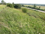 |
This territory protects the shore of the onetime Baltic lake of ice, which most significant part stretches for 10 kilometres on the eastern side of the Grobiņa-Ventspils highway from Kapsēde till Vērgale bus stop. From the top of this ancient shoreline there is a lovely view of the Piejūra lowlands, but no specific viewing areas or information stands have been installed. There are protected species and habitats in the territory. |
|
 |
The Oak of Kemeri which grows in front of the Pienenīte
preschool on Tukums Street is of local importance and is
protected.
|
|
 |
No Vilsandi bākas un tai tuvākās apkaimes ir labi saskatāmas leģendārās Vaikas salas. Tām ir piešķirts rezervāta statuss, tādēļ salas var apskatīt tikai no attāluma. Mazākā no saliņām - Kullipank ir tikai pārdesmit metrus diametrā. Tā ir jūras ūdeņu izrobots zemas un asas dolomīta klints fragments, kas klāts ar oļiem, nelieliem laukakmeņiem un kādu atsevišķi stāvošu lakstaugu. Domājams, ka vētru laikā tā pazūd zem jūras ūdens. Savukārt, Alumine Vaigas – Apakšējā Vaikas sala ir lielākā no sešām salām. Šīs salas diametrs ir ~ 150 m un tā paceļas vismaz kādus divus metrus virs jūras līmeņa. Uz salas ir bagātīga veģetācija un pat kāds zems krūms salas centrā. Redzami arī metru augsti atsegumi. Uz salas vēl joprojām atrodas 20. gs. sākumā celto „putnu māju” paliekas, kas bija domātas ligzdojošo putnu piesaistīšanai. |
|
 |
Skaisto un mūsdienās atjaunoto zilā krāsojuma ēku Karaīmu ielas 5 malā sākotnēji (1810. g.) cēla Dominikāņu mūki. Kopš 1864. g. tajā 23 gadus saimniekoja policija, līdz 1887. g. te izvietoja pastu un telegrāfu. Šobrīd ēkā atrodas nacionālā parka administrācija. |
|
 |
The farm specializes on growing and reprocessing cranberries and blueberries. They offer tastings of the products and purchasing those in a small local shop, as well as a 2-hour-long excursion around the farm. |
|
 |
The museum is dedicated to the writer Ernests Birznieks-Upītis (1871–1960), whose nickname as a child used to be Pastariņš. The historic buildings have been restored according to the situation in the mid-20th century. Rye bread, Sun bread, and Shepherd's bread are baked in the museum’s farm. Each spring visitors can take part in building wattle and other types of fences, to bake bread and rolls and to taste the results. In December – baking sklandrauši (a carrot-based pastry). There are weaving demonstrations, butter churning demonstrations and opportunities to try one’s hand at other old-time farm work. |
|
 |
This institution offers a look at characteristic rituals that relate to environmental transformation, as well as at ancient Baltic faiths. Family and calendar celebrations are held here, including weddings, hen parties, consecration, mid-winter activities, etc. Some of these are pagan festivals. The educational programmes are meant for adults. |
|
 |
Elly offers home-made ice-cream, accommodation and a delicious breakfast in the morning.
|
|
 |
Glempings atrodas Amatas pagasta Dīķīšos, kur viesus sagaidīs Samojedu šķirnes suņi un inteliģenti ēzelīši, kas aizvedīs līdz glempingam dīķīša pakājē. Glempinga teltī ir lielā gulta un divguļamais dīvāns ar gultasveļu un dvieļiem, ledusskapis, svaigs ūdens, Nespresso kafijas aparāts un tējkanna, šķīvji, krūzes, glāze, ēšanas instrumenti. Ārpus telts pieejama āra duša, mazmājiņa ar ūdeni un dezinfekcijas līdzekļiem, latvju zīmēm rotāta ugunskura vieta ar iesmiem, malku un ērtiem krēsliem vakara baudīšanai, galds ar krēsliem ēšanai, bērniem smilškaste ar mantām, peldvieta. Naktsmāja ir piemērota arī cilvēkiem ratiņkrēslā, tajā skaitā ar atbilstoši izbūvētu mazmājiņu. Šis piedāvājums ir tapis sadarbībā ar sociālo uzņēmumu "Kultūras tūrisms". |
|
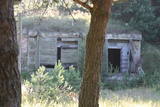 |
The 77th Zenith Missile Brigade of the Soviet Army was charged with air defences along the Soviet Union’s external border. The facility is owned by the regional local government and is not used for anything. There is an interesting gate at the entrance to the facility, however.
|
|
 |
A bar with a modern interior that offers street food from around the world, modern Latvian cuisine, including meat, fish and vegetarian dishes, as well as a wide range of drinks. |
|


