
| No | Name | Description |
|---|---|---|
 |
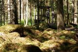
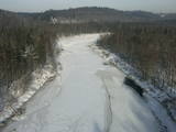
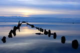
The so-called Christmas battles between the Russian and the German military took place in 1916, during World War I. Latvian riflemen demonstrated such courage and heroism during these battles that they became known far beyond Latvia’s borders. Machine Gun Hill now has a memorial to the Latvian riflemen. The viewing tower on the hill has been restored. The Maztīrelis swamp and the place where the German narrow-gauge railroad used to run can be seen well from the hill. The rail tracks crossed the swamp from the North to the South, and the rows of trees in the swamp show where they were.
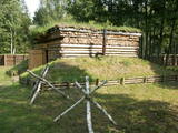
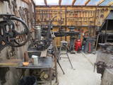
Visiting the object: You can hike the area with or without a guide. The Christmas battle museum at the Mangaļi homestead offers thematic and educational events, as well as mock battles. You can look at monuments, graves, trenches, fortifications, dugouts, etc.
The Mangaļi homestead is home to Latvia’s largest mock-up of a battle site. There are unique elements of fortifications from World War I here – ones that are related to the Christmas battles. One part of the fortifications has been reconstructed in its original location – the dugout and a part of the so-called “German rampart” that was part of the front line of the German fortifications.
|
|
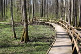 |
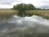
The excessively damp forests at this place include the Vēršupīte River bog, and this is one of the most diverse biotopes in Latvia in terms of the number of species that can be found here. The fact that the area is regularly flooded is shown by the fat roots of black alders – indeed, the place looks like a stand of mangroves. The wooden pathway that is the Dumbrāju trail starts at the Forest House for those who wish to examine the bog. The most impressive views are seen during spring floods or rainy seasons at other times of the year. The little river breaks out of its bed and floods a large territory. The Lake Sloka hiking trail is another place where you can study the Vēršupīte bog. The circular trail is 3 km long, and its beginning is at the Lake Sloka bird watching tower. |
|
 |
Puderova Old-Believers Prayer House. The architectural monument of local importance was built in
the beginning of the 20th century.
|
|
 |
Peaceful place in nature for great relaxation. Food is prepared from the local ingredients of Hiiumaa according to the preferences of guests. In addition, you can enjoy a genuine wood-heated sauna and bathing barrel, children's playground. |
|
 |
Lamprey catching and processing traditions started long ago in Carnikava, in the place where the River Gauja enters the sea. On the tour you can find out about lamprey and their preparation methods, as well as enjoy them grilled, jellied or in the form of lamprey sushi. Latvian cuisine: Grilled lamprey, jellied lamprey, lamprey sandwiches. |
|
 |
Saimniecības zemi, kas atrodas starp Ulbroku un Vālodzēm, 1929. gadā nopirka tagadējā saimnieka – Dzintara Āboliņa vectēvs. Tajā laikā arī tika uzcelta klēts, kurā glabāja saimniecībā izaudzēto lauksaimniecības produkciju. Krīvu klēts atdzimšana notika pirms 20 gadiem, kad tagadējie saimnieki tajā uzsāka veidot muzeju no sadzīves priekšmetiem un darba instrumentiem, kas savulaik izmantoti Krīvu saimniecībā. |
|
 |
The forest around Kaltene features a natural miracle – the rocks of Kaltene, which are also known as the barrier rocks. The rocks are 2-3 m from the sea and date back to the Ice Age. The Devil’s rock is the largest one. It used to be a beautiful pile of rocks that “stretched to the tops of the trees.” In older maps it is described as being 20 m high. It had many natural rocks, including some that were completely round, while others resembled plates. The rock was almost completely destroyed in the 1960s and 1970s, when it was chopped up to build roads. A fairly small part of the rock survives today, and it is 300 m long and 2 m high. Scientists believe that these rocks used to be sacred locations, because there are many legends and stories about them. There is a forest path with wooden pathways, information stands and a small car park there. (Source: Roja TIC) |
|
|
|
Atrodas Riekstusalas pussalas galā. No tā labi pārskatāma aizaugušā Kaņiera ezera ziemeļu un austrumu daļa. Izcila putnu vērošanas vieta. Pie torņa atrodas viena no retajām Latvijas kadiķu audzēm. Turpat meklējams Kaņiera ezera niedru laipas (uz pontoniem) sākums. |
|
 |
One of Northern Europe's oldest universities (founded in 1632). Many famous people and scientists have studied here. Main building (1804. – 1809.) is one the country's most excellent monuments of Classical architecture. |
|
 |
Zemnieku saimniecības "Imantas" galvenais darbības virziens ir olu ražošana. Te iespējams apskatīt lauku saimniecībā dzīvojošos dzīvniekus un dažādu šķirņu vistas, uzzinot kaut ko jaunu vai sen piemirstu par vistām un olām. Piedāvā arī iegādāties lauku olas. |
|
 |
Saimniecība audzē dažādus dārzeņus, lapu salātus, gurķus, dilles, ķiplokus, brokoļus, ziedkāpostus, sīpolus, ķirbjus, bietes utml. Vasarā un rudenī pieejamas avenes. Pārdošanā svaigi dārzeņi un augļi. |
|
 1 day
|
Kihnu is the largest island in the Gulf of Riga, with an area of 16.4 km2. It is only 7 km long and 3.3 km wide. Kihnu's cultural space and traditions are included on the UNESCO List of the Intangible Cultural Heritage of Humanity. There are four villages on the island and the islanders still wear national dress as everyday apparel. The unique atmosphere of the island can be experienced during a guided day programme. Kihnu Mare, the local guide, has developed her own traditional culture network with the people who have the know-how and skills to demonstrate for visitors the different aspects of Kihnu culture: the language, the traditional clothes, farming and fieldwork, handicrafts, the preparation of traditional foods, folklore, church life, singing, and dancing at weddings and village parties, as well as their traditions surrounding the sea, fishing, seal hunting and living with nature. |
|
|
|
A small town on the way from Riga to Bauska. Town's name is first mentioned in written sources in 1492. Here you can see Lutheran Church and former Manor Park |
|
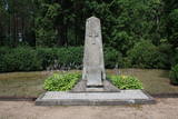 |
This is the largest cemetery of the brethren from the World War I period, and it is the final resting place for some 1,800 Latvian Riflemen, as well as some 2,000 soldiers who served in various Russian army units and were reinterred during the 1930s. There is a monument at the centre of the graveyard. |
|
 |
The impressive Gauja River valley and its best natural and cultural landscapes can be seen from Paradīze (Gleznotāji) Hill, the Sigulda castle ruins, the aerial tram, the Ferris wheel, the Ziediņi and Pilsēta ski trails, the area of the bobsled and sledding trail, Ķeizarskats, the viewing area of the Velnala cliffs, the mountain bike route of Sigulda (on the right bank of the Gauja, particularly when the trees are bare), the area of the Krimulda castle ruins, Dainu Hill, and the Turaida castle tower.
|
|
 |
Dabas liegums veidots ezera, tā salu, ainavas, augu, putnu un sikspārņu aizsardzībai. Liegumu var apskatīt "no malas" - no ceļa, kas iet gar tā ziemeļu un ziemeļaustrumu robežu.
|
|
 |
The trail tells about grey dunes which have survived thanks to the border restrictions and the presence of military. The trail starts from the parking place at the mouth of the Užava river. It is one of the few natural rivermouths in Europe. One can also see the „tacis”, an industrial installation for lamprey (Lampetra fluviatilis) fishing during their spawning migration period. The 3km long trail is circular. It winds for 1.5km from the Užava rivermouth to the North, along the coastline (the beach is covered with sand and pebbles), and returns to the starting point by a gravel road through grey dunes. Along the trail, one can observe a distinct white dune with rare plant species Linaria loeselii, Lathyrus maritimus, Anthyllis arenaria, Tragopogon heterospermus. About 1km from the rivermouth, in the sea, one can see a wrack of a sailing ship (parts of frame). The visibility depends on the flow of sand in the sea. The way back opens a beautiful view of the range of grey dunes. Unfortunately, Scots Pine starts taking over the area. There are three important biotopes of EU significance: „Fixed dunes with herbaceous vegetation 2130”, „Decalcified fixed dunes with Empetrum nigrum 2140” and „Dunes with Salix arenaria 2170”, forming a unique mosaic. Typical species here: mountain Alison ‘(Alyssum gmelinii), Pasqueflower (Pulsatilla pratensis), Sand Pink (Dianthus arenarius), Rosemary Leaved Willow (Salix rosmarinifolia), Dark Red Helleborine (Epipactis atrorubens), Kinnikinnick (Arctostaphylus uva-ursi). As a former military site, some military constructions can be seen here like horseshoe-shaped sand ramparts by the road in gray dunes. They were built to disguise military vehicles in case of sea attack. By the Kangroti graveyard, towards the Užava river, there is an underground pillbox. It is a one-man fortification to fire along the coastal perimeter. The Mouth of River Užava walking route is in the nature reserve „Užava” |
|
 |
This is a swamp into which sulphurous waters flow, and it is on the left bank of the Abava River valley. This is the only place in Latvia where the protected shrubby cinquefoil is found in the wild. This bush covers approximately one-fifth of the restricted territory. It also includes forests, various kinds of meadows and sulphurous streams, including the one which is known as the Devil’s Eye. |
|
 |
Kaltene features several homes where shipbuilders used to live – Caurnāši, which was home to the Bertliņi family, Ilmati, where six ailing ships were built, Maizītes, where the Stahl family of ship builders built 16 two-mast and three-mast ships, and Dambekalni, which was once one of the first canned fish factories on the coastline. To the side of the sea are the old boat piers of Kaltene. In 1936, a board pier was built by the Freijs family from Roja. It was 200 m long and had room for some 50 boats. All that is left are wooden poles that have been eaten away by the sea and time. If you want to learn about the specifics, difficulties and challenges of fishermen today, visit Ervīns Vilciņš in Ķirķrags. He will tell interesting stories on the basis of his experience. You can watch as he fishes in the morning and then taste the fish that he has caught. (Source: Roja TIC) |
|
 |
The ancient Abava River Valley between Kandava and the place where the river flows into the Venta River is the most expressive river valley segment in Kurzeme in terms of landscape and terrain. The valley is 30 to 40 metres deep and as much as 300 metres wide. The territory is distinguished by great diversity of a biological nature (more than 800 kinds of plants), featuring many different biotopes and natural monuments such as streams, waterfalls, cliffs, huge rocks, and many cultural and historical monumentssmall towns such as Kandava and Sabile. In both cases, the town centres are national monuments of urban construction. Popular tourist destinations include Vīnakalns hill in Sabile, where wine-making grapes are grown, as well as the open-air art museum at Pedvāle. To protect cultural treasures, a cultural and historical territory, “Abava River Valley” has been established. Wild livestock live at Drubazas and Tēvkalni to “maintain” the landscape. There are nature trails for tourists, and the Abava is the most popular river for water tourists in Kurzeme. Information is available at the tourist information centres in Kandava and Sabile. such as castle hills, churches, ancient burial grounds, and
|
|


