
| Нo | Название | Описание |
|---|---|---|
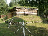 |
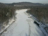
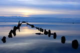
Место, где во время Второй мировой войны в 1916 году прошли так называемые Рождественские бои между войсками Германии и России, после которых слава о мужестве и героизме латышских стрелков прозвучала далеко за пределами страны. На Пулеметной горке создано мемориальное место латышским стрелкам и восстановлена смотровая вышка. С нее хорошо просматривается болото Мазтиреля с линией бывшей немецкой узкоколейной железной дороги, которая пересекает его в северо-южном направлении. Здесь можно прогуляться как в сопровождении гида, так и без него, посетить дом Мангали музея Рождественских боев, рядом с которым был создан особый познавательный маршрут, поучаствовать в тематических образовательных мероприятиях и в постановках боев. Можно осмотреть памятники, захоронения воинов, траншеи, фортификации, землянки и многое другое. Также можно осмотреть так называемый «Немецкий вал» - реконструированный участок оборонной системы – блиндаж и часть передовой линии немецкой обороны. |
|
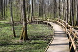 |
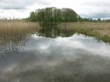
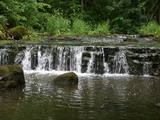
The excessively damp forests at this place include the Vēršupīte River bog, and this is one of the most diverse biotopes in Latvia in terms of the number of species that can be found here. The fact that the area is regularly flooded is shown by the fat roots of black alders – indeed, the place looks like a stand of mangroves. The wooden pathway that is the Dumbrāju trail starts at the Forest House for those who wish to examine the bog. The most impressive views are seen during spring floods or rainy seasons at other times of the year. The little river breaks out of its bed and floods a large territory. The Lake Sloka hiking trail is another place where you can study the Vēršupīte bog. The circular trail is 3 km long, and its beginning is at the Lake Sloka bird watching tower. |
|
 |
Моленная Пудеревской старообрядческой общины. Архитектурный памятник местного
значения, построенный в начале 20 века.
|
|
 |
Спокойное место на лоне природы, где можно отлично отдохнуть. Из доступных в окрестностях Хийумаа продуктов здесь готовят различные блюда, следуя пожеланиям гостей. Кроме того, здесь можно насладиться аутентичной сауной с дровяным отоплением, искупаться в бочке, а для детей оборудована игровая площадка. |
|
 |
В Царникаве ‒ в том месте, где Гауя впадает в море, ‒ уже в старину развивались традиции ловли и переработки миноги. Во время экскурсии можно узнать о миноге и о том, как ее перерабатывают, а также попробовать миногу гриль, приготовленную на углях, миногу в желе и суши из миноги. Латышская кухня: Жареная минога на решетке, миноги в желе, булочки с миногой. |
|
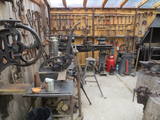 |
Saimniecības zemi, kas atrodas starp Ulbroku un Vālodzēm, 1929. gadā nopirka tagadējā saimnieka – Dzintara Āboliņa vectēvs. Tajā laikā arī tika uzcelta klēts, kurā glabāja saimniecībā izaudzēto lauksaimniecības produkciju. Krīvu klēts atdzimšana notika pirms 20 gadiem, kad tagadējie saimnieki tajā uzsāka veidot muzeju no sadzīves priekšmetiem un darba instrumentiem, kas savulaik izmantoti Krīvu saimniecībā. |
|
 |
В Калтенском лесу можно увидеть овитое преданиями чудо природы – Калтенские калвы или Валовые калвы. Происхождение нагромождений камней в в лесу в 2–3 км от моря связано с береговыми образованиями Балтийского ледникового озера. Велна калва – самое большое нагромождение. В свое время Велна калва было красивым нагромождением камней, такое огромное, что «достигало верхушек деревьев». На более ранних картах обозначена абсолютная высота нагромождения над уровнем моря – 20 м. В нагромождении было много камней своеобразной формы. Среди них много полностью шарообразных, а также камней тарельчатой формы. Это нагромождение почти полностью было разрушено в 1960 – 1970 годах, раздробив камни на щебень для строительства дорог. До наших дней осталась только относительно небольшая нижняя часть нагромождения, длина которого примерно 300 м, а высота 2 м. Ученые высказывают также мнение, что калвы в древности могли быть святыми местами, так как о них сохранилось много преданий. Для осмотра оборудована благоустроенная природная тропа с мостками, информационными стендами и небольшой площадкой для стоянки автомашин. (Источник: Ройский ТИЦ) |
|
|
|
Atrodas Riekstusalas pussalas galā. No tā labi pārskatāma aizaugušā Kaņiera ezera ziemeļu un austrumu daļa. Izcila putnu vērošanas vieta. Pie torņa atrodas viena no retajām Latvijas kadiķu audzēm. Turpat meklējams Kaņiera ezera niedru laipas (uz pontoniem) sākums. |
|
 |
One of Northern Europe's oldest universities (founded in 1632). Many famous people and scientists have studied here. Main building (1804. – 1809.) is one the country's most excellent monuments of Classical architecture. |
|
 |
Zemnieku saimniecības "Imantas" galvenais darbības virziens ir olu ražošana. Te iespējams apskatīt lauku saimniecībā dzīvojošos dzīvniekus un dažādu šķirņu vistas, uzzinot kaut ko jaunu vai sen piemirstu par vistām un olām. Piedāvā arī iegādāties lauku olas. |
|
 |
Saimniecība audzē dažādus dārzeņus, lapu salātus, gurķus, dilles, ķiplokus, brokoļus, ziedkāpostus, sīpolus, ķirbjus, bietes utml. Vasarā un rudenī pieejamas avenes. Pārdošanā svaigi dārzeņi un augļi. |
|
 1 день
|
Kihnu is the largest island in the Gulf of Riga, with an area of 16.4 km2. It is only 7 km long and 3.3 km wide. Kihnu's cultural space and traditions are included on the UNESCO List of the Intangible Cultural Heritage of Humanity. There are four villages on the island and the islanders still wear national dress as everyday apparel. The unique atmosphere of the island can be experienced during a guided day programme. Kihnu Mare, the local guide, has developed her own traditional culture network with the people who have the know-how and skills to demonstrate for visitors the different aspects of Kihnu culture: the language, the traditional clothes, farming and fieldwork, handicrafts, the preparation of traditional foods, folklore, church life, singing, and dancing at weddings and village parties, as well as their traditions surrounding the sea, fishing, seal hunting and living with nature. |
|
|
|
Небольшой городок по дороге из Риги в Бауску. Название города впервые упоминается в письменных источниках в 1492 г. Объекты для осмотра: лютеранская церковь и парк бывшей господской усадьбы. |
|
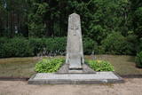 |
Самое большое братское кладбище воинов Первой мировой войны в Латвии. На нем похоронены 1800 латышских стрелков и в 30-е годы прошлого века перезахоронены 2000 солдат, служившие в разных частях Российской армии. В центре кладбища установлен памятник. |
|
 |
The impressive Gauja River valley and its best natural and cultural landscapes can be seen from Paradīze (Gleznotāji) Hill, the Sigulda castle ruins, the aerial tram, the Ferris wheel, the Ziediņi and Pilsēta ski trails, the area of the bobsled and sledding trail, Ķeizarskats, the viewing area of the Velnala cliffs, the mountain bike route of Sigulda (on the right bank of the Gauja, particularly when the trees are bare), the area of the Krimulda castle ruins, Dainu Hill, and the Turaida castle tower.
|
|
 |
Dabas liegums veidots ezera, tā salu, ainavas, augu, putnu un sikspārņu aizsardzībai. Liegumu var apskatīt "no malas" - no ceļa, kas iet gar tā ziemeļu un ziemeļaustrumu robežu.
|
|
 |
The trail tells about grey dunes which have survived thanks to the border restrictions and the presence of military. The trail starts from the parking place at the mouth of the Užava river. It is one of the few natural rivermouths in Europe. One can also see the „tacis”, an industrial installation for lamprey (Lampetra fluviatilis) fishing during their spawning migration period. The 3km long trail is circular. It winds for 1.5km from the Užava rivermouth to the North, along the coastline (the beach is covered with sand and pebbles), and returns to the starting point by a gravel road through grey dunes. Along the trail, one can observe a distinct white dune with rare plant species Linaria loeselii, Lathyrus maritimus, Anthyllis arenaria, Tragopogon heterospermus. About 1km from the rivermouth, in the sea, one can see a wrack of a sailing ship (parts of frame). The visibility depends on the flow of sand in the sea. The way back opens a beautiful view of the range of grey dunes. Unfortunately, Scots Pine starts taking over the area. There are three important biotopes of EU significance: „Fixed dunes with herbaceous vegetation 2130”, „Decalcified fixed dunes with Empetrum nigrum 2140” and „Dunes with Salix arenaria 2170”, forming a unique mosaic. Typical species here: mountain Alison ‘(Alyssum gmelinii), Pasqueflower (Pulsatilla pratensis), Sand Pink (Dianthus arenarius), Rosemary Leaved Willow (Salix rosmarinifolia), Dark Red Helleborine (Epipactis atrorubens), Kinnikinnick (Arctostaphylus uva-ursi). As a former military site, some military constructions can be seen here like horseshoe-shaped sand ramparts by the road in gray dunes. They were built to disguise military vehicles in case of sea attack. By the Kangroti graveyard, towards the Užava river, there is an underground pillbox. It is a one-man fortification to fire along the coastal perimeter. The Mouth of River Užava walking route is in the nature reserve „Užava” |
|
 |
This is a swamp into which sulphurous waters flow, and it is on the left bank of the Abava River valley. This is the only place in Latvia where the protected shrubby cinquefoil is found in the wild. This bush covers approximately one-fifth of the restricted territory. It also includes forests, various kinds of meadows and sulphurous streams, including the one which is known as the Devil’s Eye. |
|
 |
В Калтене можно осмотреть следующие родные дома кораблестроителей: «Цаурнаши» – хутор семьи Бертлиньшей, «Имантас» – возле этого хутора были построены 6 парусников; «Майзитес» – хутор кораблестроителей Шталсов, здесь были построены 16 двухмачтовых и трехмачтовых гафельных шхун; хутор «Дамбекални» – здесь позднее находился один из первых консервных заводов на побережье. Со стороны моря можно найти и старые Калтенские мостки – причал для лодок. В 1936-м году причал построили мастера по фамилии Фрейc – отец с сыновьями из Рои. Длина причала составляла 200 м. У причала можно было разместить около 50 лодок. Море и время сделали свое дело и ныне здесь остались только деревянные столбы. Для ознакомления со спецификой труда, трудностями и вызовами для современного рыбака стоит вернуться в Киркрагс к местному рыбаку Эрвину Вилциньшу. Рыбак интересно расскажет о своем труде, можно будет увидеть как добывается утренний улов и позже его продегустировать. (Источник: Ройский ТИЦ) |
|
 |
The ancient Abava River Valley between Kandava and the place where the river flows into the Venta River is the most expressive river valley segment in Kurzeme in terms of landscape and terrain. The valley is 30 to 40 metres deep and as much as 300 metres wide. The territory is distinguished by great diversity of a biological nature (more than 800 kinds of plants), featuring many different biotopes and natural monuments such as streams, waterfalls, cliffs, huge rocks, and many cultural and historical monumentssmall towns such as Kandava and Sabile. In both cases, the town centres are national monuments of urban construction. Popular tourist destinations include Vīnakalns hill in Sabile, where wine-making grapes are grown, as well as the open-air art museum at Pedvāle. To protect cultural treasures, a cultural and historical territory, “Abava River Valley” has been established. Wild livestock live at Drubazas and Tēvkalni to “maintain” the landscape. There are nature trails for tourists, and the Abava is the most popular river for water tourists in Kurzeme. Information is available at the tourist information centres in Kandava and Sabile. such as castle hills, churches, ancient burial grounds, and
|
|


