
| No | Name | Description |
|---|---|---|
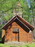 |
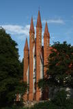
Krupenišku Old-Believer Prayer House was built in 1908. The autor of the
design is engineer I. Ivanov. At present the church is in bad tehnical condition.
|
|
 3 days
|
Šis ir viens no 6 ceļojuma maršrutiem sērijā "Baudi laukus!", un tas aicina apmeklēt Lauku Labumus – visdažādāko veidu un nozaru saimniecības un uzņēmumus, kas atvērti apmeklētājiem, piedāvā ekskursijas, nogaršot, apskatīt un iegādāties savus ražojumus. Tur apskatāmi mājdzīvnieki, mūsdienīgas lauku saimniecības, amatnieku darbnīcas, iegādājami lauku produkti – maize, medus, mājas vīns un alus, siers, ogas, augļi, zivis, gaļa, dārzeņi, tējas un citi laukos audzēti labumi. Pa ceļam iespējams ieturēt pusdienas lauku krodziņos. |
|
 |
Naukšēni Winery is an organic farm producing cider from Paradise apples. Our Story Apples Ciders For Visitors Where to Buy |
|
 5 days
|
Duke Jacob of Courland was a ruler of the Duchy of Courland and Zemgale for 40 years (1642-1682). There were great changes during his rule, with the ship building industry developing rapidly, the first factories appearing, and agricultural output improving. The duke had a large fleet that brought grain, meat, butter, wool, timber and all that was manufactured at baronial estates in Zemgale and Courland to Western Europe. The fleet was so big and strong that its ships sailed not just to Europe, but also all the way to Tobago and Gambia, where colonies were established to bring sugar, coffee and spices to Europe. The duchy built ships, manufactured paper and saltpetre and wove textiles, brocade and tapestries. Iron manufacturing was highly developed, and ore was imported from Sweden. This made it possible to forge nails, anchors, bells, cannons and other firearms. The duchy produced vodka, vinegar and gunpowder for which there was great demand in Europe, because there were attacks and defences that required it. As much as 25 tonnes of gunpowder were produced each year. One of the gunpowder towers is still in Kandava, though it has been rebuilt many times. The duchy manufactured sails and ropes, as well as hemp ropes. It was said that the fleet of the Queen of England would not have existed without those ropes. The duke also thought about selection of grain, bred livestock, improved land with land reclamation and tried to expand output from his fields. Jacob did not manage to do everything that he wanted to do. A canal to avoid the Venta rapids was not finished, and plans such as the colonisation of Australia were not finished. Yet the era of Duke Jacob was a period of great change in the territory of Latvia, and it has not gone unnoticed that the great achievements of the duke occurred on a small plot of European land. That proves that wise management can ensure lots of progress. |
|
 |
Uibo farm offers customers fresh pork dishes, using as little preservatives and additives as possible, characterised by traditional Estonian flavours. |
|
 |
This is a territory that is unique at the Latvian and the Baltic level, one which stretches from Valmiera to the Gulbene District. Here we find the irregular Gauja River valley with a dense system of ancient rivers. The meadows on the banks of these rivers are important in terms of biological diversity. There are stands of oak and broad-leaf trees. Many rare and protected birds live and next here – the corn-crake, the woodpecker, etc. The territory is excellent for bird watching, nature studies, ecological tourism and various kinds of active tourism. |
|
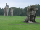 |
A Nazi concentration camp was at this location during World War II, and there is information to suggest that more than 50,000 residents of occupied Europe were murdered here. This is one of the largest ensembles of its type, taking up 25 hectares of land. It was opened in 1967 and has large groups of sculptures, including “Mother,” “Solidarity,” “Unbroken One” and “The Path of Suffering.” The wall of the entrance gates has a thematic exhibitions. |
|
 |
Der Turm war der Eckturm der mittelalterlichen Stadtmauer von Pärnu. Der Turmhof ist ein beliebter Ort für Kunsthandwerkermärkte und ein Veranstaltungsort. |
|
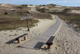 |
Die Dünen nördlich Pervalka über dem ehemaligen Dorf Negeln. Eine 9 km lange Strecke mit den wüstenartigen Landschaften. Stegpfade. |
|
 |
Handicraft house Heltermaa is a local Hiiumaa grocery and handicraft shop, open during the summer season. The selection is very wide, starting from ceramic dishes and ending with Hiiumaa lemonade. |
|
 |
Traķu pirmsākumi ir meklējami Senajos Traķos, kas atrodas 4 km dienvidaustrumos no Traķu centra. Uzskata, ka Senos Traķus ir dibinājis Lietuvas dižkunigaitis Ģedimins (~ 1275. – 1341.) 14. gs. pirmajā pusē. 14. gs. otrajā pusē šeit uzcēla mūra pili, no kuras līdz mūsdienām ir saglabājušies tikai nostāvināti zemes vaļņi. Laikā no 1345. – 1382. g. tajā valdīja Ģedimina dēls – Ķēstutis (1297. – 1382.). Senajos Traķos dzimis arī viens no izcilākajiem viduslaiku Lietuvas valdniekiem – Ķēstuta dēls - Vītauts Dižais. Kā pilij, tā arī tās valdniekiem bija nozīmīga loma sekojošajos krusta karos un cīņās. 1391. g. pils tika sagrauta cīņas laikā ar Vācu ordeni, kādēļ arī zaudēja savu stratēģisko nozīmi. 1405. g. benediktīniešu mūki šajā vietā uzcēla baznīcu, bet 18. gs. beigās - jaunu un lielāka apjoma klosteri, kura vienu no korpusiem 1889. g. pārbūvēja par baznīcu. |
|
|
|
Metāla tornis Kazari upes kreisajā krastā, ~ 5 km attālumā no Matsalu līča. No torņa redzamās Kazari deltas palieņu pļavas atrodas tikai 0,3 – 1 m augstumā virs jūras līmeņa, tādēļ pavasara palos un stipru vētru (īpaši rietumvēju) laikā ūdens appludina milzīgu teritoriju. Uzskata, ka platības ziņā šīs ir vienas no lielākajām Eiropas palieņu pļavām, kas ir nozīmīga dažādu tārtiņveidīgo putnu sugu ligzdošanas, dzērvju un zosveidīgo putnu atpūtas un barošanās vieta. Ir pagājis laiks, kad zemnieki Matsalu pļavās ganīja govis un pļāva sienu, tādēļ šobrīd pļavu apsaimniekošanu veic nacionālā parka administrācija. |
|
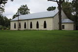 |
Jau pēc dievnama veidola var spriest, ka vēl ne tik sen – padomju laikos ēka bija izmantota citām vajadzībām. Pēc 2. pasaules kara to atsavināja draudzei, bet torni – uzspridzināja, dievnamā ierīkojot noliktavu. 20. gs. deviņdesmitajos gados draudze uzsāka baznīcas atjaunotni un tagad tā kalpo savam pamatmērķim. |
|
 |
Located in Daugmale, surrounded by the waters of the Daugava. This special location allows the bees to harvest and bring high-quality honey that has been recognised several times in Latvian contests, as well as other beekeeping products. |
|
 |
The owner is a sauna master, healer, masseur and Reiki master who is interested in ethnic culture and offers guests real leisure and health improvements that have been tested by his ancestors -- sauna programmes, the secrets of medicinal plants, restoration of links to nature, as well as entertainments on the water. |
|
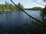 |
Dabas parks, kura lielāko daļu aizņem neprastās formas un līčiem bagātais Cārmaņa (arī Cārmins) ezers. Ezera ūdens ir ļoti tīrs, tādēļ tajā sastopamas Latvijai retas augu sabiedrības. Tā kā parka teritorijā nav tūristiem veidota infrastruktūra, interesenti var baudīt skatus, kas paveras uz ezera un tā apkārtni no Aulejas – Grāveru ceļa.
|
|
 |
Kihnu farm offers traditional Kihnu island dishes from home-grown vegetables and local fish. |
|
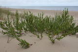 |
The territory is established in order to protect the dunes and the seashore habitats. There are beautiful beaches and wooded dunes, and the paved Klaipēda–Palanga bikeway trails through the park, which is worth travelling at full length. |
|
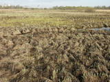 |
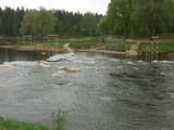
Natural flood-land meadows along the banks of the Lielupe before Jelgava. Many protected plants are found here, and birds nest and rest here during migration season.
|
|
 12 days
|
The tour introduces visitors to varied landscapes, local traditions and historic sites. Travellers are usually surprised that such a small territory holds so many contrasts. Riga offers a medieval Old Town and elegant Art Nouveau district, then comes Sigulda with three castles on the high banks of the Gauja river valley. Saaremaa island is a pleasure to drive around with good quality, quiet roads, windmills, medieval churhes and ethnographic villages. Tallinn has its walled Old Town while Lahemaa national park has an almost mystical landscape There is also elegant Palmse Manor. The tour goes through sleepy villages in eastern Latvia with distinctive pottery, ancient culinary traditions, and the Catholic pilgrimage site of Aglona. Vilnius' historic centre has distinctive baroque churches. The massive sand dunes of the Curonian Spit and Nida with its characteristic blue framed windows are among Lithuania's most attractive sights. Trakai has its picturesque medieval castle on the lake as well as the small Karaitis ethnic comunity with their unique traditions and food. Port towns Klaipeda and Liepaja have both developed into bustling modern cities with lively cafe culture. |
|


