
| No | Name | Description |
|---|---|---|
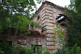 |
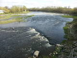
Atrodas Kraujā – Daugavas ielejas krasta malā un nogāzēs. Atrodama informācija, ka šajā vietā Livonijas kara laikā atradusies krievu karaspēka nometne. Muižas nosaukums cēlies no vācu Hof zum Berg – „Kalnu muiža”. Pēdējie muižas īpašnieki līdz 1. pasaules karam bija grāfu Šahno dzimtas pārstāvji. Viens no tiem – Marians Šahno 1910. gadā uzceļ muižas pili, kas bija būvēta eklektisma formās. Daļēji nojaukta tā pārdzīvo padomju laikus, līdz 2002. gadā nodeg. Līdz mūsdienām saglabājušās vien ēkas sienas, kuras slēpj biezs augājs. Var tikai iedomāties, kādi skati šeit kādreiz pavērušies uz Daugavas ieleju! Muižas parks ir vietējo iedzīvotāju pastaigu vieta. |
|
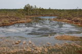 |
Iepazīstina ar Somā nacionālā parka lielākā purva – Kureso (Kuresoo) ziemeļaustrumu daļu, kur redzamas purva ezeriņu un lāmu ainavas. Takas sākumā atrodas igauņu komponista, ērģelnieka un folkloras vācēja Marta Sāra (Mart Saar) (1882. – 1963.) dzimtās mājas. To apkaimē pļavas apsaimnieko aitas. Lokveida takas garums ir 4,2 km. |
|
 |
The "Dzirnavinas" café is along the Rīga-Liepāja highway (A9) at the 67th km road marker. Travellers love to stop here for lunch. Latvian cuisine: Sorrel soup, marinated herring with cottage cheese, “Countryside Feast” (potatoes, eggs, smoked meat, marinated pickles), pork steak haché, Kurzeme stroganoff, sautéed sauerkraut with hunter’s sausages, barley porridge with meat, rye bread cream, bread soup with whipped cream. |
|
 3 days
|
The Liv Coastline involves a series of shoreline villages from Ovīši to Ģipka along the shores of the Baltic Sea and the Bay of Rīga. Like Latvians, Livs are an indigenous population in Latvia, with ancestors who lived here at least 5,000 years ago. They populated extensive parts of Kurzeme and Vidzeme, and the area in which they lived the longest was Northern Kurzeme, on the shores of the Baltic Sea. Today visitors to the Liv Coastline mill meet real Liv fishermen, feel the aroma of smoked fish, enjoy traditional dishes, look at diverse ancient fences, learn about the reticent charm of the local landscape, enjoy the place where two seas, birds and people meet at Cape Kolka, hear the Liv dialect of the Latvian language, see rounded hillocks and swampy areas, visit the Šlītere lighthouse, and see the green-white-blue Liv flag, red bilberries, bird migration routes and blue cows. The oldest evidence of the life of Livs can be found in the Liv centres. The Liv language and culture are still alive in place names, handicrafts, folk costumes, and the world view and lifestyle of people who live in the area. The Liv language and cultural values are part of Latvia's national cultural heritage, and traditional Liv culture is part of the Latvian Canon of Culture. |
|
 |
Lauku sētas atrodas pie upītes, ciema nomalē, kas jau izsenis bijusi mājvieta biškopjiem. Vieta piemērota mierīgai atpūtai. Izglītojošas nodarbības ikvienam, kas ir ieinteresēts Dzūkijas kulinārajā mantojuma, amatniecībā un tradīcijās. Maizes cepšana, pīrāgi ar sēnēm, olu rotāšana ar vasku, pinumi no salmiem. Vakarēšana ar dzuku dziesmām un dejām. Tautastērpu izgatavošana gan bērniem, gan pieaugušajiem. |
|
 |
Above and below the town of Kuldīga, the Venta River is distinguished by a variety of biotopes – hillside forests, sandstone and dolomite cliffs, meadows, protected plants and animals, and diverse landscapes. There are popular tourism objects in this part of Kurzeme – the Venta dam, the stone bridge of Kuldīga, the Veckuldīga castle hill, etc. An ecological tourism trail runs along the banks of the Venta, and a bicycling trail has been installed on its left bank. |
|
 |
A family-owned company that makes culinary and confectionery products in Jaunannas Parish, Alūksne Municipality. Delicious meat roulettes and rolls, prepared using Grandmother's recipes, and other meat products in a wide assortment, as well as special "Gustiņa" confectionery products can be purchased in Alūksne - taste store "Gustiņš". In the café “Gustiņš” you can enjoy a delicious and rich homemade meal, and taste the special dishes characteristic to the locals of Alūksne – malēnieši (booking in advance). |
|
 |
This arboretum park is in a lovely place – the Blue Hills of Ogre, where there is a tower with a good view of the Daugava River Valley. The landscape is enlivened by a pond and its streams. There are beautiful hiking trails throughout the park.
Unique species: The Amur Cork Tree (Phellodendron amurense) and the Field Elm (Ulmus minor), among others.
|
|
 |
Mākslinieka un koktēlnieka Antano Česnulio koka skulptūru parks atrodas Naujasodė ciematā, aptuveni 3 km attālumā no Druskininku pilsētas. Ekspozīcija tiek regulāri atjaunota ar jauniem darbiem. |
|
 |
The house is on the eastern shore of Lake Lubāns with a wonderful view of Latvia’s largest lake. The owners prepare dishes from local freshwater fish, using old recipes and ones that they have developed themselves. "Zvejnieki" is the participant of Latgalian culinary heritage. Latvian cuisine: Porridge with homemade jam, fish soup, bream or pike cakes, smoked carp, sautéed wild duck, sautéed elk, wild berries with milk. Special foods: Oven-baked pike-perch with potatoes or vegetables. |
|
 |
Atrodas Skolas ielā 12, Priekules pamatskolā. Tās krājumā ir plašs Priekules novadā iegūto vēsturisko liecību klāsts – sadzīves priekšmeti, darbarīki, dokumenti, padomju gados izsūtīto un represēto cilvēku atmiņu stāsti u.c. liecības, kā arī Priekules skolu attīstības vēsture. |
|
 |
Built in the 18th century and rebuilt in the mid-19th
century, the parsonage was the place where the Liv flag was first consecrated. Renovations
of the parsonage are underway at this time. Since September 2009, it has been used
by the Latvian Evangelical Lutheran Church as a rest home for its Recollection Centre.
|
|
 |
The restaurant and deli is located in Cēsis, on the way from Valmiera. Modern interior, relaxed atmosphere and delicious dishes from the produce of local farmers. The menu is rich not only with meat and fish dishes, but also with a wide range of vegetarian dishes. |
|
 |
The landlady of this farm will tell you about healthy herbal teas and home-based goodies. If you wish to spend the night under the stars, we offer a place for tents and a campfire on the banks of local river by the old Lūkas windmill. “Aploki” will welcome anyone who wants to relax in a peaceful and quiet atmosphere. |
|
 8 days
|
The tour from Rīga to Tallinn combines natural and cultural heritage and includes lovely landscapes and 15 nature trails which cross marshlands, meadows and forests along the shores of the Baltic Sea, including several protected nature reserves. Many trails are equipped with viewing towers for birdwatching. Randu meadows near Ainaži contains one third of Latvia’s entire plant species. A boardwalk leads through reeds to a viewing platform with views over the meadow and the sea. Saaremaa island is interesting with very different natural attractions to the mainland - dolomite cliffs, juniper heaths, a meteorite lake and rocky sea shore. The tour passes rural farms and traditional villages typical of the coastal areas. Hiiumaa island is a laid back place and retains a very Estonian atmosphere with an important bird reserve at Käina Bay, unusual Sääre Tirp as well as several small islets off its south-eastern coast. Back on the mainland, Paldiski peninsula gives a glimpse of the recent history with its former Soviet military base |
|
 |
The No. 521 Border Guard post at Ovīši is owned by the Defence Ministry and is closed to civilians. Visitors can only look at the ruins of some buildings in the dunes.
|
|
 |
Jau kopš 2009. gada decembra, kad tika reģistrēta saimniecība, Dainis Erbss ir pilnībā pievērsies kazkopībai, izmantojot dabas sniegtās iespējas, lai radītu augstvērtīgus kazas piena produktus. Dainis ir pieredzējis kazkopis un siera meistars, kurš kopā ar dzīvesbiedri Tatjanu apsaimnieko piemājas saimniecību “Dāri”, kur audzē aptuveni 100 kazu lielu ganāmpulku. Sieri Kā top siers Apmeklētājiem Kur iegādāties sierus
|
|
 |
Namdaris Rinalds Dundurs būvē, atjauno un restaurē vecās koka ēkas. Veido nestandarta masīvkoka mēbeles, bērnu rotaļlietas un lampas. Darbus veic sadarbojoties ar Latvijas dizaineriem. |
|
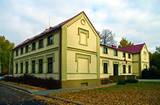 |
In 1888, the building, provided for a doctor’s needs, was donated by Baron Alexander Alexei von Pistohlkors to the parish of Pēterupe Lutheran Church. Along with the building, Baron Pistohlkors also donated 6 hectares of land and 10 000 roubles for the doctor’s use. Arvēds von Engelhards became the first medical doctor in Pēterupe. In 1890, the first pharmacy was opened in one room of the clinic, serving people from a wide area; it remained in the building until 1895. This outpatient clinic was the very first stone building in Saulkrasti, the first health authority in a wide area, as well as the first pharmacy. Through its entire lifetime, the house was maintained from voluntary donations – at first by Alexander Alexei von Pistohlkors, then by churchgoers of Pēterupe Parish – therefore by the money of the villagers. |
|
 2 days
|
This section of the Baltic Coastal Hiking Route is suitable to hardy hikers who like to travel across uninhabited places. In many places, reeds, floodplains with pastures and wetlands stretch across the Estonian seacoast, which is why the itinerary often leads you along forest and country roads. In the second half of summer you can pick the mushrooms and berries in the coastal forests. Pärnu is a popular resort city with many cafés, live music, SPAs, hotels and a beautiful Old Town. |
|


