
Nature objects in Estonia

What's special about the nature in Estonia?
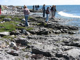
In Estonia, there stands the most impressive rock wall in the Baltics - the so called North Estonian "glint" (from Estonian language). Estonia has its own "Land of Inlets" - the Lahemaa region with its national park, the "Land of Islands" - the Saaremaa island and the Monzund archipelago. The Matsalu bay is one of the most significant rest stops for birds during their migration. In Estonia there is one of the most prominent impact craters in Europe, there are the greatest waterfalls and boulders in the Baltics, the Munamagi hill - the highest spot in the Baltics, the Lake Peipus - the 5th largest lake in Europe, - with long-standing fishing traditions, and the great variety of nature from West to East, from North to South.
Act responsibly - follow the Green advice!
| Overview | Details |
|---|---|
 |
Estonia
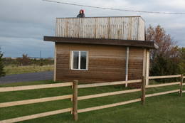
Halbinsel PärispeaAuf der Küste der Halbinsel befinden sich sowohl ehemalige Fischerdörfer, als auch die Reste eines Militärstützpunkts der Sowjetarmee. Großartige von den Gletschern des Eiszeitalters eingebrachte Feldsteine.  74 74
Services
74km - Distance from countries capital city |
 |
Estonia
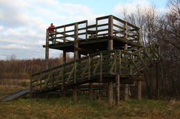
Ignatsi pargajienu taka (Ignatsi matkarada)Taka iesākumā ved pa mežu ieskautu bijušo šaursliežu dzelzceļa līniju, pa kuru pagājušā gadsimta vidū izveda kokmateriālus. Tās tālākā daļa izmet nelielu loku pa Suistna purvu (Suistna raba), kur uzcelts skatu tornis ar izcilu sūnu purva ainavu ar nelieliem ezeriņiem. Takas garums vienā virzienā ir 4,5 km. |
 |
Estonia
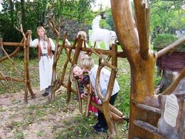
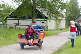
Metsamoori (Woods Crone) Family ParkThis park is a network of farms in Kaika area where visitors can learn about healthy life styles and alternative medicine. Farms have programmes on using herbs and leech in therapies, on the magical worlds of bees and mushrooms, spells and meditation. In workshops you can learn to use weeds in cooking, make bread and herbal drugs. Individual travellers are welcome to explore the farm on their own. 275
 5-9 5-9
Services
275km - Distance from countries capital city
5-9 Active season months |
 |
Estonia
Stein MajakiviDer dritgrößte Feldstein im Baltikum (584 m3, 7 m hoch, Durchmesser bei dem Grund – 32 m ). Auf estnisch bedeutet „Hausstein”. Befindet sich am Rande des Pikanõmme – Majakivi Pfades (4,5 km lang). 60
Services
60km - Distance from countries capital city |
 |
Estonia
Hjupasares pargajienu taka (Hüpassaare matkarada)Iepazīstina ar Somā nacionālā parka lielākā purva – Kureso (Kuresoo) ziemeļaustrumu daļu, kur redzamas purva ezeriņu un lāmu ainavas. Takas sākumā atrodas igauņu komponista, ērģelnieka un folkloras vācēja Marta Sāra (Mart Saar) (1882. – 1963.) dzimtās mājas. To apkaimē pļavas apsaimnieko aitas. Lokveida takas garums ir 4,2 km. 169
Services
169km - Distance from countries capital city |
 |
Estonia
Erdi taka (Öördi rada)1,2 km gara taka, kas pa purvainu mežu aizved līdz Ērdi purvam (Öördi raba) un tā austrumu daļā esošajam Ērdi ezeram (Öördi järv), pie kura izveidota atpūtas un peldvieta. |
 |
Estonia
Kidevas (Kiideva) putnu verosanas platformasPirmā ir uzcelta uz vienstāvīgā apmeklētāju centra jumta. No tās paveras plašs skats uz Kīdevas ciemu, ostu un niedrēm apaugušo Matsalu līča ziemeļdaļu. Austrumos no šīs atrodas vēl viena - divstāvīga putnu vērošanas platforma. No Kīdevas līdz Puisei gar Matsalu līča var doties pārgājienā pa 5 km garo dabas taku. To izejot, novēroto putnu sugu klāsts noteikti būs lielāks! |
 |
Estonia
Kihnu islandCultural space of Kihnu (www.kultuuriruum.ee) is incorporated in the UNESCO list of Masterpieces of Oral and Intangible Heritage of Humanity, and is a quaint mix of old and modern. The local history museum displays tools, clothes, handicraft and furniture. 180
1-12
Services
180km - Distance from countries capital city
1-12 Active season months |
 |
Estonia
Skatu platforma Puises ciemaPuises „centrā” uz vienstāvu koka mājiņas jumta izveidota skatu platforma. No tās paveras laba ainava uz ciemu, ostu un piekrastes kadiķu laukiem. 121
Services
121km - Distance from countries capital city |
 |
Estonia
Rannaje putnu verosanas tornis (Rannajõe linnutorn)Divstāvīgs skatu tornis pie Laikjula (Laiküla) – Hāpsalu ceļa, no kuras paveras plaša ainava uz Matsalu līcī ietekošo upīšu palieņu pļavām. Te var vērot migrējošās dzērves un zosis, bet pavasaros varbūt laimēsies redzēt vai dzirdēt ķikutu Gallinago media. Viens no retajiem torņiem, kas ir pielāgots cilvēkiem ar īpašām vajadzībām. |
 |
Estonia
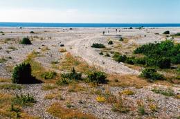
OsmussaarThis is a “peripheral” island in the Bay of Finland, 9 km from the Dirhami port. The special fact about this island is that it offers fields of juniper, a rocky and grassy seashore that is around 2 km long, and limestone cliffs that are a few metres high along the northern and the eastern shores of the island. These are designated with the words Osmussaare pank.
|
 |
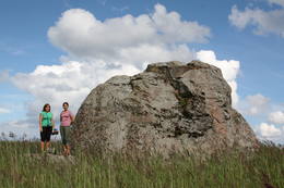
Estonia
Stein TammispeaDie Größe dieses Feldsteins ist eindrucksvoll, obwohl er nach dem Volumen (262 m3) nur der 16. größte Feldstein Estlands ist. Die Länge beträgt 10,7 m, Breite – 6,5 m, Umfang – 27,8 m. 70
Services
70km - Distance from countries capital city |
 |
Estonia
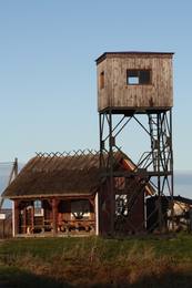
Mekonnu skatu tornis (Mäekonnu vaatetorn)Viens no diviem nacionālā parka skatu torņiem, kas atrodas ~ 1,5 km ziemeļos no Ehijerva ezera (Ähijärv). Tornis ir veiksmīgi „nomaskēts” nelielā priežu pudurī, tādēļ tas „nebojā” izcilo dabas un kultūrainavu, kas paveras no tā skatu platformas. Pie autostāvlaukuma ir izveidota labiekārtota atpūtas vieta. |
 |
Estonia
Tuhala Nature Centre and NõiakaevTuhala region has settlements of about 3000 years of age. There are 11 ancient settlement sites, 30 cult stones, 3 burial sites, 4 sacred groves, etc. Tuhala Landscape Reserve has a unique natural feature - the Nõiakaev (Witch´s Well) which “boils” up water during floods at 100 l/s, and 5 mightiest energy columns of the country. 32
1-12
Services
32km - Distance from countries capital city
1-12 Active season months |
 |
Estonia
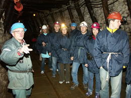
Gas mixtureGas mixture is the main raw material for Estonia’s energy and chemical industries, and it is extracted in our day from open quarries or underground shafts. This layer was established during the Ordovician Period between 450 and 480 million years ago, and it is made up of the remnants of plants and animals from that age. In the Kohtla-Nõmme suburb, there is a shaft which can be toured in the company of a guide who will tell you that this is the only layer of its kind in the Baltic States. He will tell you about how the gas mixture has been extracted over the course of history.
ServicesServices - recreational
Nature watchingIn the village of Kiviõli, in turn, you can climb an old hill of slag from the gas mixture (Vana tuhamägi). This will open up a view of one of Estonia’s most interesting landscapes. For more information: www.kivioli.ee (available in English). |
 |
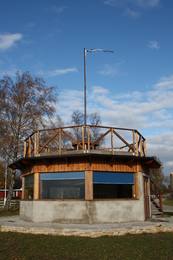
Estonia
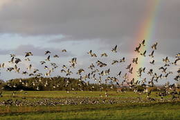
The Matsalu National ParkThis is one of the most popular bird-watching locations in Estonia, and during spring and autumn migration there are a great many different kinds of birds resting and feeding in the meadows and shallow coastal waters of the Bay of Matsalu and the Kasari River.
Services
1-12 Active season monthsServices - recreational
Boat tourBoating on the Bay of Matsalu and the Kasari River can be organised. 
Nature trailThe Kiideva-Puise hiking trial (5 km), the Penijõe trail (3 km), the Salevere information trail (1.5 km).
Nature watchingBird-watching is possible throughout the park, especially on the shorelines, in wetland meadows and heaths. There are bird-watching towers or platforms at Puise, Kiideva, Haeska, Rannajõe, Kasari jõgi, Penijõe, Suitsu and Keemu. The visitor centre is in the village of Matsalu. For more information: www.matsalu.ee (available in English). |
 |
Estonia
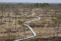
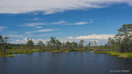
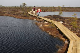
Meenikunno swampThis is a highland swamp with several little lakes. At the SE of the area is a wooden trail.
|
 |
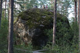
Estonia
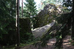
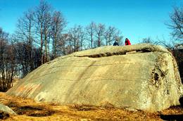
Muuga Kabelikivi rockThis is the second largest rock in the Baltic States in terms of size (728 m3). It is the only rock in the Baltic States with this form and size. It is 7 m high, 19 m long, 11 m wide, and 58 m in perimeter. Kabelikivi looks like a cliff that is halfway sunk into the earth. During the Ice Age, the rock “travelled” to this location from southern Finland. It is made of granite, and there are two other very impressive rocks alongside it.
|
 |
Estonia
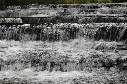
Joaveski udenskritumi (Joaveski joastik)Krāčains Lobu upes (Loobu jõgi) posms pie Joaveski ciema, kur ~ 160 m garumā upes gultnē, tai šķērsojot Ziemeļigaunijas glintu, izveidojušās izmēros nelielas, tomēr ļoti ainaviskas un skaistas 0,5 – 1 m augstas ūdenskritumu kaskādes. 1898. g. šeit uzcēla hidroelektrostaciju, kuras atliekas ir redzamas upes labajā krastā. Iecienīta pavasara laivotāju treniņu vieta. |
 |
Estonia
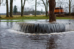
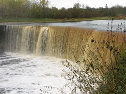
Jägala waterfallThis is one of the greatest waterfalls in the Baltic States – 8 m high and up to 70 m wide. It is most impressive in the spring and after strong rains. The waterfall and its ~300 m canyon emerged from the limestone of the Ordovician Period. You may spot some fossils there. When the water is low, courageous people try to ford the river both above and below the waterfall. The limestone and the falling water have established a unique “tunnel” there.
|
 |
Estonia
Insel HiiumaaDie zweitgrößte Insel Estlands mit breiter Waldung, Sand- und Steinstränden und einem der ältesten Leuchttürme Europas. 132
Services
132km - Distance from countries capital city |
 |
Estonia
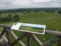
The Vooremaa field of drumlinsThis is the most visually impressive drumlin field in the Baltic States, and it is close to the village of Tabivere. The drumlins were established by ice glaciers, and they point in the direction in which the ice moved long ago. In terms of their appearance, the drumlins resemble loaf-shaped hillocks. From their “backs,” there are lovely views of the local landscape and the lakes that are around the area. The visitor centre is in the village of Äksi.
|
 |
Estonia
Nemmeveski udenskritums (Nõmmeveski juga)No vairākiem parka ūdenskritumiem noteikti ir jāapmeklē divi. 1,2 m augstais vienpakāpes Nemmeveski ir izveidojies uz Valgejegi upes (Valgejõgi), vietā kur tā šķērso Ziemeļigaunijas glintu. Šeit Valgejegi atgādina krāčainu (īpaši – pavasaros) kalnu upi, kas plūst pa vairākus metrus augstu klinšu ieskautu kanjonu. Palu laikā šo upes posmu ir iecienījuši ekstrēmie ūdenssporta veidu cienītāji. Pie ūdenskrituma un tālāk pa upi lejup redzamas ap 1920. g. celtās hidroelektrostacijas konstrukciju paliekas. |
 |
Estonia
The Vilsandi National ParkThe national park was established to protect the 100 or so small islands that make up the archipelago of the local area. The largest island, the Vilsandi Island, is 6 km long and up to 2 km wide. You can rent a boat to get there, or, during appropriate conditions, you can walk across the sea and the small islands from the southern end of the Kuusnõmme peninsula.
Services
255km - Distance from countries capital cityServices - recreational
Boat tourBoat along the islands of the archipelago, but keep in mind that the Vaika Island and the Nootamaa Island are nature reserves which are closed to visitors.
Nature trailHike the route Loona-Kuusnõmme (8 km), hike around the Vilsandi Island (~12-15 km), hike the Harilaid peninsula (~10 km).
Nature watchingBird-watching from the southern end of the Vilssandi Island – the nearby Vaika Island is closed to visitors. There is a viewing tower on the N end of the Kuusnõmme peninsula. The visitor centre of the park is found at the Loona estate (Loona mõis). |
 |
Estonia
Tuhala Karst area, Witch’s wellOne of the largest karst areas in Estonia is found here. The unique Witch’s well is one of the most interesting parts of this area. During spring floods (not every year, and for only a short period of time), the well erupts with underground river waters to create an unusually powerful karst stream that can pump out as much as 100 litres per hour.
|
 |
Estonia
Kemu skatu tornis (Keemu vaatetorn)Meklējams Matsalu līča dienvidu krastā pie Kēmu ostas (Keemu sadam). Blakus sešus metrus augstajam metāla – koka tornim uzcelts neliels apmeklētāju centrs. Tāpat kā no Haeskas torņa, arī no šī paveras viena no izcilākajām Matsalu līča un tā piekrastes ainavām. Laba putnu vērošanas vieta migrāciju laikā. 129
Services
129km - Distance from countries capital city |
 |
Estonia
Torna kalns (Tornimägi)Karulas augstienes augstākais reljefa punkts (137 m.vjl.), kas virs tuvākās apkārtnes paceļas par ~ 60 m. Torņa kalnā ir uzbūvēts skatu tornis ar ļoti plašu apkārtskatu. Uz tā platformas ir novietoti panorāmas fotoattēli, kuros atzīmēti zīmīgākie plašākā apkaimē redzamie objekti – apdzīvotas vietas, pilskalni, baznīcu torņi u.c. Turpat izveidota atpūtas vieta un meklējams Rebases ainavu takas sākums. 260
Services
260km - Distance from countries capital city |
 |
Estonia
Piirissaar islandThe island of 7.5 km2 in Lake Peipsi is largely inhabited by Russian-speaking Old Believers who have broadly retained their old traditions through time. Traditional trades are fishing and growing vegetables, mainly onion. 262
1-12
Services
262km - Distance from countries capital city
1-12 Active season months |
 |
Estonia
Moor TolkuseDurch das höchste Dünen-Massiv Estlands und den Moor führt der Lehr-Wanderweg. Blick vom Aussichtsturm bis auf die Insel Kihnu. 175
Services
175km - Distance from countries capital city |
 |
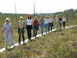
Estonia
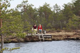
The Soomaa National ParkThe word “Soomaa” means “land of the swamps” in Estonian. There are several major swamps in this area, along with rivers, lowland meadows, wetland forests, and other biotopes that are of key importance in terms of the diversity of species. Major floods occur here in the spring, which is known by locals as the “fifth season''. The fifth season is the best time to explore the landscape of Soomaa. Services
150km - Distance from countries capital city
1-12 Active season monthsServices - recreational
Fishing
Cross-country skiingDuring the winter, there is cross-country skiing and hikes across frozen swamps. The visitor centre is in Tõramaa. For more information: www.soomaa.com (available in English).
Boat tourCanoeing is possible on flooded territories and down the rivers of the park.
Nature trailWalking tours in the park
Nature trailHike the area in the presence of a guide, go “bog-shoeing”, hike the Riisa swamp trail (5 km, with watching tower), the Ignatsi trail (4.5 km, with watching tower), the Beaver information trail (3 km), the Tõramaa trail (2.5 km, with watching tower), and other trails and routes in the park.
Nature watchingYou can go on a beaver safari and look for other animals in the company of a guide. |


