
Nature objects in Estonia

What's special about the nature in Estonia?
In Estonia, there stands the most impressive rock wall in the Baltics - the so called North Estonian "glint" (from Estonian language). Estonia has its own "Land of Inlets" - the Lahemaa region with its national park, the "Land of Islands" - the Saaremaa island and the Monzund archipelago. The Matsalu bay is one of the most significant rest stops for birds during their migration. In Estonia there is one of the most prominent impact craters in Europe, there are the greatest waterfalls and boulders in the Baltics, the Munamagi hill - the highest spot in the Baltics, the Lake Peipus - the 5th largest lake in Europe, - with long-standing fishing traditions, and the great variety of nature from West to East, from North to South.
Act responsibly - follow the Green advice!
| Overview | Details |
|---|---|
 |
Estonia
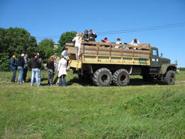
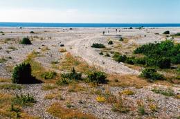
Kusnemmes pussala (Kuusnõmme poolsaar)Ap 6 km garā pussala ir vieta, kur jānokļūst tiem, kas grasās doties vienā no neparastākajiem pārgājieniem pāri jūras šaurumam. Cauri Kūsnemmes pussalai līdz tās ziemeļu daļai iet šaurs un ļoti līkumains grants ceļš (ar garāku tūristu autobusu jābrauc lēni un uzmanīgi), kura galā izveidots autostāvlaukums, neliels namiņš, kur patverties lietus un vēja laikā, kā arī informācijas stends. Turpat redzamas divas Padomju armijas „KRAZ” tipa automašīnas. Lai sasniegtu robežkontroles posteni, Padomju robežsargi brauca pa jūru un mazajām saliņām, kas kā pērļu virtene savieno Kūsnemmes pussalas galu ar Vilsandi salas dienviddaļu. Turpat divas desmitgades pēc Igaunijas neatkarības atjaunošanas „KRAZ” automašīnu kravas kastēs vasaras laikā uz Vilsandi vizināja tūristus, taču spēkrati savu mūžu ir nokalpojuši un unikālais piedāvājums vairs nav spēkā! Ko darīt? Pa mazajām saliņām uz Vilsandi var doties ar kājām. To var īstenot tikai siltā laikā, kad nav gaidāms stiprs vējš un ir zināma laika prognoze vismaz divām tuvākajām dienām. Kā sava veida orientieris var kalpot augstsprieguma elektrolīnija. Kopumā ir jārēķinās arī ar 1 h 40 – 2 h ilgu un ~ 4 km garu gājienu. Dziļākā vieta (ja ietur pareizo „kursu”) atrodas pārgājiena sākumdaļā, kur starp saliņām izveidots laivu ceļš - ~ 1 m dziļa vieta atkarībā no vēja virziena un ūdens līmeņa. Zināmu priekšstatu par maršrutu sniegs redzamā ainava, kas paveras no skatu torņa. Kaut arī šis maršruts tiek reklamēts dažādos informatīvajos materiālos, atbildību par tā veikšanu uzņemas katrs pats!  257 257
Services
257km - Distance from countries capital city |
 |
Estonia
Viking villageA unique theme park on the River Pirita evokes interest in ancient Vikings. Facilities include: stronghold, chamber of spells, smithy, Viking boat and dugout canoe trips, shows and battles with ancient weapons, a catapult, archery, axe throwing, cave and smoke saunas, trout fishing, accommodation, catering etc.  30
30
 1-12 1-12
Services
30km - Distance from countries capital city
1-12 Active season months |
 |
Estonia
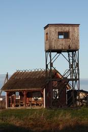
Kidevas (Kiideva) putnu verosanas platformasPirmā ir uzcelta uz vienstāvīgā apmeklētāju centra jumta. No tās paveras plašs skats uz Kīdevas ciemu, ostu un niedrēm apaugušo Matsalu līča ziemeļdaļu. Austrumos no šīs atrodas vēl viena - divstāvīga putnu vērošanas platforma. No Kīdevas līdz Puisei gar Matsalu līča var doties pārgājienā pa 5 km garo dabas taku. To izejot, novēroto putnu sugu klāsts noteikti būs lielāks! |
 |
Estonia
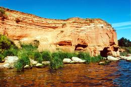
The sandstone cliffs of KallasteThis is one of the few places in the Baltic States where one can find Devonian period sandstone cliffs featuring abrasion caves, arches, etc. The cliffs are on the shores of Lake Peipsi (Peipsi järv), near Kallaste, and they are between two and four (in some cases – nine) metres high, stretching for a distance of around one km.
ServicesServices - recreational
Nature trailHike along the shores of the lake to and from the cliffs (3 km). 
Nature watchingThere is a viewing tower which offers a good look at Lake Peipsi and the shoreline. For more information: www.kallaste.ee (only in Estonian). |
 |
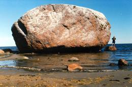
Estonia
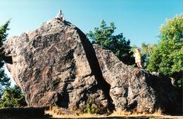
The Rock of Jana - TomaThe Rock of Jana - Toma is claiming itself to be the highest (almost 8 m) rock in The Baltic. It is located in Kasispea village. 72
Services
72km - Distance from countries capital city |
 |
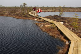
Estonia
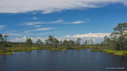
Moorpfad ViruEin 3,5 km langer Pfad quert den Viru Moos in Richtung Süd–Nord. Von einem Holzaussichtsturm eröffnet sich einen Blick auf eine typische Hochmoorlandschaft mit einigen Seen, Aushöhlungen und morastigen Stellen. 56
Services
56km - Distance from countries capital city |
 |
Estonia
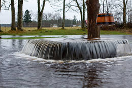
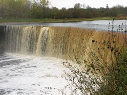
Jägala waterfallThis is one of the greatest waterfalls in the Baltic States – 8 m high and up to 70 m wide. It is most impressive in the spring and after strong rains. The waterfall and its ~300 m canyon emerged from the limestone of the Ordovician Period. You may spot some fossils there. When the water is low, courageous people try to ford the river both above and below the waterfall. The limestone and the falling water have established a unique “tunnel” there.
|
 |
Estonia
The Haanja Nature ParkThis park was set up to protect the landscape and cultural environment of the Haanja highland. At the central part of the park are the two highest hills in the Baltic States – Suur Munamägi, which stands 318 m above sea level, and Vällamägi, which is 304 m above sea level. The ancient Rõuge River valley (Rõuge ürgorg) is found in the western part of the park. It is 7.5 km long and up to 60 m deep. The valley dates back to the Ice Age, and it has seven lakes, including the deepest one (38 m) in Estonia – Lake Rõuge Suurjärv.
ServicesServices - recreational
Bicycle trailBike the route Rõuge-Nursi-Tindi-Rõuge (15 km).
Nature trailThe Vällamäe nature trail (2.2 km) is the highest trail in terms of elevation in the Baltic States. You may hike the wooden trail of the Hinni canyon and the hiking route of the Rõuge River valley (10 km), or the trail of Lake Kavadi (Kavadi järv) (4.5 km).
Nature watchingThere are viewing towers at Suur Munamägi and on the eastern shore of Rõuge Suurjärv. For more information: www.haanjapark.ee (only in Estonian). |
 |
Estonia
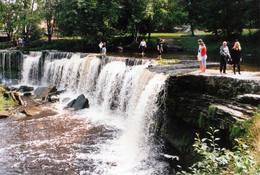
Keila waterfallThis is one of the loveliest waterfalls in Estonia – up to 6 m in height and 50 m in width. Recommended: The rapid Keila River has carved a cliffy canyon behind the waterfall, with a flow of water that falls down a major distance. It’s worth hiking through the Keila park to the shore of the Bay of Finland (~1 km), then returning along the other bank of the river.
Services
31km - Distance from countries capital cityServices - recreational
Nature trailThe rapid Keila River has carved a cliffy canyon behind the waterfall, with a flow of water that falls down a major distance. It’s worth hiking through the Keila park to the shore of the Bay of Finland (~1 km), then returning along the other bank of the river. |
 |
Estonia
The Lahemaa National ParkThis is the first national park in Estonia and the Baltic States. Perfect for a day trip out from Tallinn for a hiking trip and nature watching. It was established in 1971 to protect the area that is along the Bay of Finland – the shoreline, forests, swamps, meadow biotopes, species, natural monuments, rocks, waterfalls, cliffs and cultural monuments such as ancient cemeteries, castle hills, baronial estates, fishing villages, etc. Services
50km - Distance from countries capital cityServices - recreational
Cross-country skiingFor cross-country skiers, the Käsmu peninsula is perfect during the season.
Bicycle trailFor bikers, there’s the Käsmu peninsula (~10 km), the route Loksa-Pärispea-Viinistu-Kasispea on the Pärispea peninsula (here you will find the highest rock in the Baltic States – the Jaani-Tooma rock (kivi, 7.8 metres high).
Nature trailYou can hike a wooden train over the Viru swamp (Viru raba, 3.5 km), another trail on the Käsmu peninsula (~15 km), and the Pikanõmme-Majakivi trail (4.5 km), along which you will find the third largest rock in the Baltic States – the so-called House Rock (Majakivi), which has a size of 584 m3. We also suggest the informational Altja trail (3 km).
Nature watchingThere are viewing towers in the Viru raba swamp and along the Piaknõmme-Majakivi trail. There is a visitor centre at Palmse. |
 |
Estonia
Haeskas putnu verosanas tornis (Haeska linnutorn)Pamatīgs trīsstāvu koka tornis, no kura atklājas viens no labākajiem Matsalu līča un tā apkaimes palieņu pļavu skatiem, kuras apsaimnieko mājlopi, veidodami piemērotu vidi dažādām putnu un augu sugām. Laba migrējošo zosveidīgo putnu vērošanas vieta. Tā kā tornis ietilpst Tūlingu (Tuulingu) saimniecības teritorijā – spēkrats ir jāatstāj netālu esošajā autostāvlaukumā, bet suņi jāved piesieti kakla siksnā. |
|
|
Estonia
Insel HiiumaaDie zweitgrößte Insel Estlands mit breiter Waldung, Sand- und Steinstränden und einem der ältesten Leuchttürme Europas. 132
Services
132km - Distance from countries capital city |
|
|
Estonia
Skizentrum OtepääDas größte im Baltikum. Marathonloipe von Tartu, Wand der künstlichen Felsen und Trasse der Radmarathon. Skimuseum. Auf der Tehvandi-Sprungschanze ist ein Aussischtsplatform eingerichtet. 225
Services
225km - Distance from countries capital city |
 |
Estonia
Nemmeveski udenskritums (Nõmmeveski juga)No vairākiem parka ūdenskritumiem noteikti ir jāapmeklē divi. 1,2 m augstais vienpakāpes Nemmeveski ir izveidojies uz Valgejegi upes (Valgejõgi), vietā kur tā šķērso Ziemeļigaunijas glintu. Šeit Valgejegi atgādina krāčainu (īpaši – pavasaros) kalnu upi, kas plūst pa vairākus metrus augstu klinšu ieskautu kanjonu. Palu laikā šo upes posmu ir iecienījuši ekstrēmie ūdenssporta veidu cienītāji. Pie ūdenskrituma un tālāk pa upi lejup redzamas ap 1920. g. celtās hidroelektrostacijas konstrukciju paliekas. |
|
|
Estonia
Abruka IslandThis is the 11th largest Estonian island, and its central section is covered by a broadleaf forest (linden, oak, elm and other trees) that is more than 100 years old. Along the shores, the Abruka Island has meadows and small areas of wetlands. Only the northern part of the island is populated. Few tourists come to call, which means that the island is relatively untouched by humankind.
ServicesServices - recreational
Nature trailHike across the island or along its NE shoreline (7 km). For more information: www.abruka.ee (available in English).
Nature watching |
 |
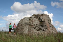
Estonia
Muuga Kabelikivi rockThis is the second largest rock in the Baltic States in terms of size (728 m3). It is the only rock in the Baltic States with this form and size. It is 7 m high, 19 m long, 11 m wide, and 58 m in perimeter. Kabelikivi looks like a cliff that is halfway sunk into the earth. During the Ice Age, the rock “travelled” to this location from southern Finland. It is made of granite, and there are two other very impressive rocks alongside it.
|
 |
Estonia
The Soomaa National ParkThe word “Soomaa” means “land of the swamps” in Estonian. There are several major swamps in this area, along with rivers, lowland meadows, wetland forests, and other biotopes that are of key importance in terms of the diversity of species. Major floods occur here in the spring, which is known by locals as the “fifth season''. The fifth season is the best time to explore the landscape of Soomaa. Services
150km - Distance from countries capital city
1-12 Active season monthsServices - recreational
Fishing
Cross-country skiingDuring the winter, there is cross-country skiing and hikes across frozen swamps. The visitor centre is in Tõramaa. For more information: www.soomaa.com (available in English). 
Boat tourCanoeing is possible on flooded territories and down the rivers of the park.
Nature trailWalking tours in the park
Nature trailHike the area in the presence of a guide, go “bog-shoeing”, hike the Riisa swamp trail (5 km, with watching tower), the Ignatsi trail (4.5 km, with watching tower), the Beaver information trail (3 km), the Tõramaa trail (2.5 km, with watching tower), and other trails and routes in the park.
Nature watchingYou can go on a beaver safari and look for other animals in the company of a guide. |
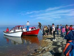 |
Estonia
Pärimusmatkad/Heritage ToursThe company provides wildlife tours – seal watching, walking, cycling or skiing trips, rubber boat trips to Vilsandi and other islands, orchid trips, and trips to learn about culture and life of the manors, towns and villages, crafts and seafaring. Miku forest park in Vilsandi National Park is where visitors can learn about and try various forestry jobs. 200
1-12
Services
200km - Distance from countries capital city
1-12 Active season months |
 |
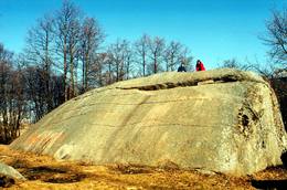
Estonia
The Letipea Ehalkivi rockThis is the largest rock in the Baltic States and, according to some sources, in all of the segment of Northern Europe which was affected by the last Ice Age. Its size is 930 m3! The rock is 7.5 m high, 16.5 m long and 14 m high, with a circumference of 48.5 m. The rock resembles a huge pebble from a distance, and it is on the sandy and rocky beach. Depending on the season, it can be out in the water. The Ice Age carried the rock to its current location from the southern shore of Finland. It is made of pegmatite.
|
 |
Estonia
Kemu skatu tornis (Keemu vaatetorn)Meklējams Matsalu līča dienvidu krastā pie Kēmu ostas (Keemu sadam). Blakus sešus metrus augstajam metāla – koka tornim uzcelts neliels apmeklētāju centrs. Tāpat kā no Haeskas torņa, arī no šī paveras viena no izcilākajām Matsalu līča un tā piekrastes ainavām. Laba putnu vērošanas vieta migrāciju laikā. 129
Services
129km - Distance from countries capital city |
 |
Estonia
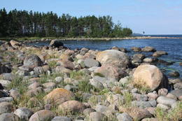
Halbinsel PärispeaAuf der Küste der Halbinsel befinden sich sowohl ehemalige Fischerdörfer, als auch die Reste eines Militärstützpunkts der Sowjetarmee. Großartige von den Gletschern des Eiszeitalters eingebrachte Feldsteine. 74
Services
74km - Distance from countries capital city |
 |
Estonia
Kihnu islandCultural space of Kihnu (www.kultuuriruum.ee) is incorporated in the UNESCO list of Masterpieces of Oral and Intangible Heritage of Humanity, and is a quaint mix of old and modern. The local history museum displays tools, clothes, handicraft and furniture. 180
1-12
Services
180km - Distance from countries capital city
1-12 Active season months |
 |
Estonia
OsmussaarThis is a “peripheral” island in the Bay of Finland, 9 km from the Dirhami port. The special fact about this island is that it offers fields of juniper, a rocky and grassy seashore that is around 2 km long, and limestone cliffs that are a few metres high along the northern and the eastern shores of the island. These are designated with the words Osmussaare pank.
|
 |
Estonia
Moor TolkuseDurch das höchste Dünen-Massiv Estlands und den Moor führt der Lehr-Wanderweg. Blick vom Aussichtsturm bis auf die Insel Kihnu. 175
Services
175km - Distance from countries capital city |
 |
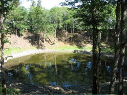
Estonia
Kaali meteorite cratersThis is actually a group of nine craters, and some of them are as much as 100 m in diameter and 16 m in depth. This is the most visually expressive meteorite crater in the Baltic States and, indeed, in all of Europe. Remnants of the meteorite – some 2.5 kg in all – yielded iron and nickel. It is thought that this pan-Baltic natural catastrophe occurred 2,600 to 4,000 years ago. Kaali Visitor Centre comprises the meteoritics and limestone museum, a conference hall and a hotel.The museum exhibits genuine meteorite pieces amongst other items. The hotel has all modern conveniences, tasty food is provided at Kaali Tavern nearby. 204
1-12
Services
204km - Distance from countries capital city
1-12 Active season months |
 |
Estonia
Tartu-PiirissaareThis is a quick boat ride from Tartu down the Emajõgi River to Piirissaare Island in Lake Peipsi (Peipsi järv). Along the lower reaches of the river are major wetlands which are of enormous importance for birds.
ServicesServices - recreational
Boat tourTake the ship from Tartu to Piirissaare (65 km) and just enjoy the landscapes along the banks of the river.
Nature watchingThere is a viewing tower on Piirissaare Island. For more information: www.visittartu.com (available in English). |
 |
Estonia
Meteoriten-kraterfeld von KaaliEins der eindrücksvollen Meteoritenkraterfelder Europas. Der Hauptkrater ist 22 m tief, Durchmesser – 110 m. Der ungefähre Zeitraum des Meteoriteneinschlags liegt ung. 7500-Jahre zurück. 205
Services
205km - Distance from countries capital city |
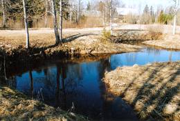 |
Estonia
Tuhala Karst area, Witch’s wellOne of the largest karst areas in Estonia is found here. The unique Witch’s well is one of the most interesting parts of this area. During spring floods (not every year, and for only a short period of time), the well erupts with underground river waters to create an unusually powerful karst stream that can pump out as much as 100 litres per hour.
|
 |
Estonia
Kuranidu macibu taka (Kuuraniidu õpperada)1,7 km gara lokveida taka, kas iepazīstina ar dažādiem meža biotopiem, to iemītniekiem un meža apsaimniekošanas pamatprincipiem. Apmeklētāju ērtības nolūkā ir izveidotas koka laipas un neliels skatu tornis. 159
Services
159km - Distance from countries capital city |
 |
Estonia
Piirissaar islandThe island of 7.5 km2 in Lake Peipsi is largely inhabited by Russian-speaking Old Believers who have broadly retained their old traditions through time. Traditional trades are fishing and growing vegetables, mainly onion. 262
1-12
Services
262km - Distance from countries capital city
1-12 Active season months |


