
| No | Name | Description |
|---|---|---|
 |
Riežupes dabas parks veidots g.k. Riežupes izteksmīgās ielejas, tai raksturīgo dabas vērtību – nogāžu un gravu mežu, dažādu ģeoloģisku dabas pieminekļu - smilšakmens atsegumu, alu, ūdenkritumu, upes straujteču posmu, dažādu sugu, mežu masīvu un ainavas aizsardzībai. Parka atrodas viens no Kurzemes populārākajiem tūrisma objektiem – Riežupes alas - garākais mākslīgo alu labirints Latvijā, kura eju kopgarums ir 460 m. Sākotnēji dabas veidotās alas 19. gs. vidū mākslīgi paplašināja baltās smilts ieguves nolūkos, kuras izmantoja stikla ražošanai. Parkā izveidots velotūrisma maršruts. |
|
 |
The Bauska Nature Park runs for several dozen kilometres along the Lielupe River and its tributaries – the Mūsa and the Mēmele. This is a protected territory. The shores of these rivers contain some of the largest dolomite cliffs in Zemgale. These are protected both as biotopes and as geological monuments. The rivers are important places for river lampreys and vimbas to spawn. Tourists will be attracted by the cultural landscape of the area, as well as the cultural monuments such as the Bauska castle, the Jumpravmuiža park, the Mežotne castle hill, Vīna Hill, the Mežotne castle, etc. The rivers are used for water tourism. |
|
 |
The ancient Abava River Valley between Kandava and the place where the river flows into the Venta River is the most expressive river valley segment in Kurzeme in terms of landscape and terrain. The valley is 30 to 40 metres deep and as much as 300 metres wide. The territory is distinguished by great diversity of a biological nature (more than 800 kinds of plants), featuring many different biotopes and natural monuments such as streams, waterfalls, cliffs, huge rocks, and many cultural and historical monumentssmall towns such as Kandava and Sabile. In both cases, the town centres are national monuments of urban construction. Popular tourist destinations include Vīnakalns hill in Sabile, where wine-making grapes are grown, as well as the open-air art museum at Pedvāle. To protect cultural treasures, a cultural and historical territory, “Abava River Valley” has been established. Wild livestock live at Drubazas and Tēvkalni to “maintain” the landscape. There are nature trails for tourists, and the Abava is the most popular river for water tourists in Kurzeme. Information is available at the tourist information centres in Kandava and Sabile. such as castle hills, churches, ancient burial grounds, and
|
|
 |
This lovely territory includes the hillocks of Embūte, which are in the ancient Embūte valley. The aim of establishing the park was to protect the landscape, biotopes and species of the region. An ecological tourism trail has been established in the valley, as has a forest trail through the nature park (accessibly only in the company of a guide). Visitors will learn about the hillocks and ravines left behind by the Ice Age. The ravines and the forests along their sides are protected biotopes. There are also important natural and cultural monuments, including the Embūte castle hill and the ruins of a baronial estate, castle and church. Other points of interest include the death place of the Courlandian warrior Indulis, the Joda dam, meadows, a viewing tower, etc. Three unmarked bicycle trails are in the area. |
|
 |
Dabas parks, kura lielāko daļu aizņem neprastās formas un līčiem bagātais Cārmaņa (arī Cārmins) ezers. Ezera ūdens ir ļoti tīrs, tādēļ tajā sastopamas Latvijai retas augu sabiedrības. Tā kā parka teritorijā nav tūristiem veidota infrastruktūra, interesenti var baudīt skatus, kas paveras uz ezera un tā apkārtni no Aulejas – Grāveru ceļa.
|
|
 |
The forests of Zvārde are located on land which used to be a Soviet air base. The territory was unpopulated and was not accessible to civilians. The vast area includes various types of forest - boreal forest, bogs of black alder, etc. The fact that the military used to control the territory is one of the reasons why the forests of Zvārde are a location where many rare and protected birds live, reproduce and find food. Some of the elements of the old air base are still in place, including a unique surveillance platform. It is recommended that visitors to the area drive only along general use roads. |
|
 |
The Dole is the largest island in the Daugava River, surrounded to the Northeast by the rapid waters of the Daugava and to the Southwest by calm and gradually overgrown waters from Dry Daugava. The island is a specially protected nature park, established in 1986 to protect the landscape and cultural and historical values of the island in the wake of the construction of the Rīga hydroelectric power plant, as well as rare and protected species of plants and animals. The island is also meant to provide education and leisure for visitors. Best known on the island is the Daugava Museum, which is in the mansion of the old Dole Estate. The museum features some 13,000 exhibits that speak to the history of the island and the river – Baltic and Livonian apparel, tools and household objects. The exhibition also presents the Daugava as an important waterway and the related history of forms of transport and rafters. In the park is an open-air exhibition with reconstructed lamprey eel traps and a barrier to fish salmon, along with a set of fishing tools. A dolomite cliff is alongside the museum on the steep shore of the Dry Daugava. The ruins of the Vecdole castle can be found on the south-eastern end of the island, near Bēči. |
|
 |
This park covers the Nemuna River valley between the villages of Seredžius and Geldaudišķis, with lovely views of castle hills, medieval castles, aristocratic estates, etc., along the shores.
|
|
 |
This park is in a region of hillocks in the Karula highlands, and Lake Ähijärve is at its centre. The park offers a cultural environment of small farms, and it was set up to protect the unique cupola-shaped hillocks of the area. Main attractions: Scenic Lake Ähijärv (176ha), Rebasemõisa Tornimägi hill (137.8 m above sea level), undulating landscapes. |
|
 |
Tītuvēnu reģionālais parks (Tytuvėnų regioninis parkas) dibināts 1992. gadā. Parkam raksturīga ainavu daudzveidība – te ir sastopami lieli mežu masīvi, purvi, ezeri, upītes. Šejienes reljefa veidotājs tāpat kā citur Baltijas valstīs ir bijis ledājs, kas atnesis un atstājis aiz sevis garas laukakmeņu grēdas. Kopumā parkā ir konstatētas 603 augu un 787 dzīvnieku sugas. Parkā aug veci un dabiski boreālie (ziemeļu) meži, veci un jaukti platlapju meži ar ozoliem, liepām, kļavām, ošiem un gobām, sugām bagāti egļu meži, staignāju meži, nogāžu un gravu meži, purvaini meži un aluviālie (pārplūstošie) meži. Parkā esošās pļavas un tīrumi ir nozīmīga dzērvju atpūtas vieta migrāciju laikā, kad te pulcējās tūkstošiem putnu. Šiluvas baznīca un Tītuvēnu klosteris ir svētceļnieku galamērķis vairāk nekā 500 gadu garumā. |
|
 |
This park is found in the Otepää highlands and offers an outstanding example of how the terrain of a protected natural territory can be used for recreation, sports and active leisure. The infrastructure of the park is perfect for such activities and is of a high level of quality.
|
|
 |
This park was set up to protect the lovely ancient valley of the Dubysa River. This is one of the most popular rivers for water tourism in Lithuania, because it has a significant drop with rapids and beautiful shorelines.
|
|
 |
The “backbone” to this park is the valley of the Šventoji (Holy) River. One of the most impressive Devonian cliffs in Lithuania can be seen from the river – Vetygalos atodanga. On the shores of the Varius stream is a cliff made of quartz and sand – Variaus atodanga. 6 km to the S of Anykščiai is Lithuania’s second largest rock (5.7 m high, ~100 m3) – Puntukas akmuo.
|
|
 |
The Nemuna River divides up into two large streams at its estuary at Kuršių Marios, and this has established the Rusnė Island. This is a unique environmental territory with wetlands, streams, ancient rivers, lagoon lakes and flood plains which are important places for birds to nest and rest during migration season. Vast tracts of this territory are flooded each spring. The park includes the territory to the N and W of Rusne (lagoons, swamps, fishing ponds, Kuršių Marios).
|
|
 |
Teritorija, kas aptuveni 20 km garumā „piekļāvusies” abiem Aiviekstes upes krastiem. Dabas parka galvenā vērtība ir palieņu pļavas (un citi pļavu biotopi), kas ir ļoti nozīmīga daudzu augu un dzīvnieku (īpaši – putnu) sugu dzīves vieta. Ūdenstūristiem, kas laivo pa Aivieksti, nakšņošana ir jāplāno tikai šim mērķim paredzētās vietās!
|
|
 |
This park was established to protect Lithuania’s longest lake, Lake Asveja (> 20 km). The lake is in a sub-glacial valley carved out by ice during the Ice Age, and it actually resembles a wide and curvy river.
|
|
|
|
Ap 9 km garā taka (vienā virzienā) sākas Skaņākalna dabas parkā (Mazsalacā) un beidzas pie Ramatas. Tā iepazīstina ar Salacas ielejas dabas parka nozīmīgākajām vērtībām – smilšakmens atsegumiem (Skaņaiskalns, Dauģēnu klintis u.c.), alām, nozīmīgu izmēru laukakmeņiem u.c. Taka marķēta. Tajā izvietoti informācijas stendi, norādes. Jāpadomā par loģistiku – kā nokļūt sākuma punktā. |
|
 |
The tower on the eastern shore of Lake Engure (next to the meadow for wild cattle, accessible from the side of Bērzciems) offers a view of the reeds, small islands, Great Island, cows and horses of the north-eastern part of the lake. The tower on the northern shore of the lake (accessible from the side of Mērsrags) offers a look at the boating facility and the very overgrown northern part of the lake. The tower at the north-western shore of the lake (accessible from the side of Ķūļciems) shows the Apaļrova island (a footpath), stands of juniper, the boating facility, and the mosaic-like landscape of the lake itself.
|
|
 |
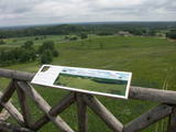
The viewing area is near the top of the Vilce castle hill, with a view of the Rukūze River valley, Zaķi meadow, and surrounding forests. This is an unusual landscape for the region of Zemgale. The Vilce baronial estate is nearby.
|
|
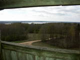 |
This is one of the highest points among the hillocks of the Selonian area of Zemgale – Borīškalns Hill. From the tower, you will see Lake Sauka, as well as the forests and farmland which surround it. The “Kalna Ļūdāni” farm is nearby, and its owner uses his livestock to help to maintain the surrounding landscape.
|
|


