
| No | Name | Description |
|---|---|---|
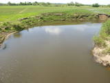 |
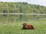
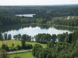
The Dviete Wetlands Nature Park contains a unique natural territory – the ancient Dviete River valley with the Lake Skuķi and the Lake Dviete and the surrounding wetland meadows. During flooding season, these wetlands store up waters from the Daugava River. They absorb a lot of floodwater at first and then slowly return it, thus reducing the level of floods in the Daugava River valley. This process is the reason for the unique ecosystem which exists in this area. It is an important location for plants and birds both during migration and nesting season. The river valley is important for birds during migration and nesting. In 2006, wild cows were released into the meadows. There is also work to improve the tourist infrastructure in the area. |
|
 |
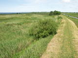
This path is found on the right bank of the ancient Abava river valley. The visitor will be able to view places where underground streams create wetlands, various kinds of meadows, a stand of juniper bushes, etc. The area is “managed” all year long by “wild” cows. The shore of the ancient valley can be climbed (some 200 steps), and the view is magnificent. It is recommended that the trail be visited in the company of a knowledgeable guide. There is a shorter path that is 600m long, along with a longer one that is more than a kilometre in length. It will take an hour or so to traverse it. Objects are found in the ancient Abava valley nature park.
|
|
 |
The nature park in the Daugava River valley is the only place between the cascades of the Daugava hydroelectric power plants there is still a chance to see the Daugava River valley and the ravines of its tributaries as they appeared before the area was flooded so that the power plants could be constructed. Particularly lovely views are found on the right bank of the river near the Aizkraukle church and castle hill. Forests, meadows, origins of streams and small dolomite cliffs in this area are all protected biotopes. Leisure facilities have been installed on the Aizkraukle castle hill, and the Aizkraukle castle ruins are not far away. |
|
 |
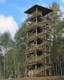
This lovely territory includes the hillocks of Embūte, which are in the ancient Embūte valley. The aim of establishing the park was to protect the landscape, biotopes and species of the region. An ecological tourism trail has been established in the valley, as has a forest trail through the nature park (accessibly only in the company of a guide). Visitors will learn about the hillocks and ravines left behind by the Ice Age. The ravines and the forests along their sides are protected biotopes. There are also important natural and cultural monuments, including the Embūte castle hill and the ruins of a baronial estate, castle and church. Other points of interest include the death place of the Courlandian warrior Indulis, the Joda dam, meadows, a viewing tower, etc. Three unmarked bicycle trails are in the area. |
|
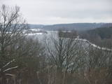 |
At the Aizkraukle Lutheran church along the upper part of the shores of the ancient Daugava River valley, there is a bit of an old road from which one of the most beautiful views of the central section of the river can be seen, particularly when the trees are bare. Approximately one kilometre to the North-west is the Aizkraukle castle hill, which offers a no less impressive view.
|
|
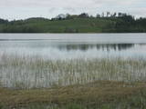 |
This nature park was established to protect the Burzava hillocks, Lake Adamova (a eutrophic lake), and the habitats and species that are found along the lake’s shores – bats included. The loveliest views of the area can be viewed from the hillocks that are on the northern shore of the lake. There are tourist accommodations on the shores of Lake Adamova where tourists can spend the night. |
|
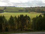 |
As you travel from Kandava to Sabile, you will find a parking lot on the right side of the road. From there, there are steps to a viewing area on the highest hill in the Abava Ancient River Valley – Greiļi Hill. This offers a wonderful view of the ancient river valley and the local mosaic of meadows and forests. The landscape is enriched by the Imula and Amula valleys that are on the other side of the ancient river valley.
|
|
 |
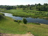
Open landscape area within farming lands on both banks of Uzava River about 10 km before it flows into the Baltic Sea. There is a good open view over the area from the Vendzava-Ziri road going through the nature park. Protection of migratory birds and corncrakes has been one of the main reasons for establishment of the nature park. Bird watching is possible from the road Vendzava-Ziri during migration period in spring and fall. There is no tourist infrastructure in the nature park.
|
|
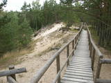 |
The trail climbs up and down along the bluffs of lower River Pilsupe and reveals a fascinating sight of three white dune exposures (the largest is called the White Dune). The trail is 900m long, and the White Dune is ca 20m high. It has formed ca 6000 years ago, in the period of the Littorina Sea which is a foregoer of the Baltic Sea. Here the first Stone Age settlement on the North Western coast of Latvia has been found in 1934 by geologist S. Burhards. In the sand, some 500m from the sea, he found some pottery fragments, a sandstone hone, a piece of flint, parts of bones and an amber bead. He handed the findings over to the National Museum of History. In October 1934, the site was checked by archaeologist E. Šturms, who found the archaeological layer, typical for such settlements, in the landslides of the Pilsupe riverbanks. In 1936 he started larger excavations to continue by 1938. Totally seven, chronologically different settlements were detected and many artefacts found, including fragments of the so called Sārnate and pit-comb pottery, as well as some pieces of corded pottery. Based on these findings, the settlement is dated back to the beginning or middle of the 3rd millenary B.C., and it has been inhabited till the beginning of the 2nd millenary B.C. Especially remarkable are three clay figures in human shape which have probably been used for some religious cult purposes. Since 1993, archaeologist Ilzes Loze has discovered several pit-comb ware culture settlements in large area around Pūrciems village. They are known in research literature as „the Ģipka settlements”. |
|
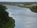 |
This lovely part of the Nemuna River between Alytus and Pakuonis meanders through cliffs that are up to 40 m high.
|
|
 |
The Bauska Nature Park runs for several dozen kilometres along the Lielupe River and its tributaries – the Mūsa and the Mēmele. This is a protected territory. The shores of these rivers contain some of the largest dolomite cliffs in Zemgale. These are protected both as biotopes and as geological monuments. The rivers are important places for river lampreys and vimbas to spawn. Tourists will be attracted by the cultural landscape of the area, as well as the cultural monuments such as the Bauska castle, the Jumpravmuiža park, the Mežotne castle hill, Vīna Hill, the Mežotne castle, etc. The rivers are used for water tourism. |
|
 |
This is one of the most outstanding areas in the entire Baltic States with active underground waterways which still, to this very day, dissolve local gypsum rock. Parts of the area collapse regularly, and there are legends about all of this. Underwater rivers, streams, the so-called Karvės (Cow) cave, etc., can be seen in the area.
|
|
 |
The Nemuna River divides up into two large streams at its estuary at Kuršių Marios, and this has established the Rusnė Island. This is a unique environmental territory with wetlands, streams, ancient rivers, lagoon lakes and flood plains which are important places for birds to nest and rest during migration season. Vast tracts of this territory are flooded each spring. The park includes the territory to the N and W of Rusne (lagoons, swamps, fishing ponds, Kuršių Marios).
|
|
 |
Atrodas Numerenes dabas parka teritorijā. 20 m augstais tornis uzbūvēts uz t.s. Numerenes vaļņa, no kura paveras plaša ainava un aizaugošām lauksaimniecības zemēm un nelielu mitrāju ar Kugreņa ezeru austrumu virzienā. Torņa apkaimē izveidota izziņas taka. |
|
 |
The Buse (Matkule) castle hill is near the Imula River. From the castle hill and from the opposite shore of the river, you can find one of the loveliest views of Kurzeme’s small rivers. Their appearance is best when trees and other flora are bare and the view is unimpeded. A wonderful view of the Imula valley is also seen on the road to the castle hill – near the Buse homestead.
|
|
 |
Teritorija, kas aptuveni 20 km garumā „piekļāvusies” abiem Aiviekstes upes krastiem. Dabas parka galvenā vērtība ir palieņu pļavas (un citi pļavu biotopi), kas ir ļoti nozīmīga daudzu augu un dzīvnieku (īpaši – putnu) sugu dzīves vieta. Ūdenstūristiem, kas laivo pa Aivieksti, nakšņošana ir jāplāno tikai šim mērķim paredzētās vietās!
|
|
 |
This territory is rich with forestland and lakes (some 285 in all). There are extensive opportunities for active recreation or calm leisure.
|
|
 |
This park is found in the Otepää highlands and offers an outstanding example of how the terrain of a protected natural territory can be used for recreation, sports and active leisure. The infrastructure of the park is perfect for such activities and is of a high level of quality.
|
|
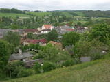 |
The Wine Hill of Sabile has been known since the age of the Duchy of Courland as the northernmost place where grapes were grown to produce more or less sour wine for the duchy. A wine festival has been held each year during the latter half of July in Sabile since 1999. The hill offers an excellent view of the small town that is on the banks of the ancient Abava River Valley. |
|
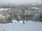 |
Gaiziņkalns Hill is the highest hill in Latvia, and it is a typical example of the hillocks of the Vidzeme highlands. This is a place of wonderful landscapes, even though there are not all that many good viewing areas. At the centre of this park is Gaiziņkalns Hill itself – the highest place in Latvia and the second highest in the Baltic States (311.6 metres above sea level). The viewing tower, alas is not open to the public, because it is in dangerous condition. There is a well-appointed hiking trail around Gaiziņkalns Hill, and during the winter the hill and its surroundings are popular for downhill and cross-country skiing. Lake Viešūrs (Lake Kaķītis) is popular among licensed fishermen. This territory is part of a region of protected landscapes around Vestiena. |
|


