
| Nr | Nosaukums | Apraksts |
|---|---|---|
 |
“Gustiņš” ir ģimenes uzņēmums, kas kopš 2002. gada Alūksnes novada Jaunannas pagastā nodarbojas ar dažādu kulinārijas izstrādājumu ražošanu, piedāvājot saviem pircējiem vairāk nekā 20 veidu gaļas rolādes, ruletes un citus gaļas izstrādājumus, kā arī 50 veidu salātus. Turpinot augt un attīstīties, 2011. gadā izveidota kūpinātava un uzsākta arī mājas kūpinājumu ražošana, kā arī atvērta kafejnīca “Gustiņš”, kuras piedāvājumā tūrisma sezonā vai pēc pasūtījuma ir arī Alūksnes novadam raksturīgie Malēniešu ēdieni. 2017. gada pavasarī “Gustiņa” sortimentu papildinājuši dažādi konditorejas izstrādājumi, no kuriem noteikti jāpiemin “Gustiņa” Kūciņas burciņā. Katru gadu pirms Ziemassvētkiem, jau sākot no novembra, pircējiem ir iespējams iegādāties un pasūtīt arī gardās un īpaši dekorētās “Gustiņa” piparkūkas. Visa produkcija tiek gatavota ar rokām gan pēc senām vecmāmiņu, gan mūsdienu receptēm, un cik vien iespējams izmantojot Latvijas zemnieku un vietējo ražotāju audzētās izejvielas un tikai dabīgās garšvielas. Ražošanā netiek izmantoti pārtikas uzlabotāji. Visu “Gustiņa” ražoto produkciju var iegādāties kulinārijas veikalā “Gustiņš” (Alūksnē, Tirgotāju ielā 10), kurā tiek piedāvāti arī citi kvalitatīvi un interesanti Latvijas ražotāju produkti. |
|
 |
Hiiu Gourmet ir mazs uzņēmums, kura mērķis ir piedāvāt produktus no vietējām izejvielām Hījumā. Izstrādājumi tiek izgatavoti ar rokām mazos daudzumos. Produktu klāstā ir mājās gatavoti sīrupi, piedevas, sinepes utt. No augiem un ogām, kas novāktas Hījumā mežos. Saimniece Heli padāvā Hījumā tradicionālā ēdiena gatavošanas meistarklases. |
|
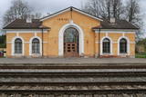 |
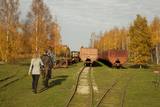
Ramocku stacija atklāta 1889. gadā reizē ar dzelzceļa Pleskava-Rīga atklāšanu. 1916.gadā pēc jauna dzelzceļa izbūves līdz Gulbenei, šīs stacijas nozīme ievērojami pieauga. 1918.gadā tā kļuva par divu dažādu sliežu platumu dzelzceļa iecirkņu saskares staciju. Intensīva vilcienu kustība caur šo staciju tika izvērsta Brīvības cīņu laikā. Sadursmes pie Ieriķu stacijas notika jau 1918.gada decembrī. 1919.gadā jūnijā te sākās Cēsu kaujas. Starp Cēsīm un Ieriķiem vācieši uzbruka igauņu bruņuvilcienam. Par dažādiem nopelniem Brīvības cīņu laikā Ieriķu apkaimē, vairāki karavīri saņēma apbalvojumus, arī Lācplēša kara ordeņus.1919. gadā stacija nodēvēta par Ieriķiem. Otrā pasaules kara laikā te atradās lokomotīvju depo.1953.gadā depo vietā izveidoja stratēģiskās rezerves tvaika lokomotīvju bāzi. Pēdējā tvaika lokomotīve L-3599 Ieriķu bāzi pameta 2002.gadā un tagad ir redzama kinopilsētā Cinevilla.Ieriķu stacija vairākkārt pārbūvēta.Otrā pasaules kara laikā nodedzināta pavisam. 1956.gadā uzbūvē pašreizējo ēku. |
|
 3 дня
|
This route section takes you to the Dzūkija National Park – it is among Lithuania’s most forested and desolate nature areas –, and to the town of Druskininkai – a popular SPA and mineral water health resort on the banks of the river Nemunas. When in Druskininkai, we recommend dipping yourself in mineral water baths, enjoying the trip with the cable car over the river Nemunas, visiting the musical fountain, and walking along the river promenade. The starting point of the hiking route is the village of Didžiasalis, which is reached by bus from Druskininkai. From there, the route will take you through vast coniferous forests, rich in berries and mushrooms, and small villages. As you get to Druskininkai, the Forest Trail will meander along the small streets and parks of the historic resort of Druskininkai, crossing the river Ratnyčia and the forest park on the right bank of the Nemunas valley. Leaving the resort town behind, the Forest Trail runs on the side of the village revealing you the beautiful landscapes and the view of the Liškiava monastery on the other bank of the river Nemunas. Up to the village of Žiogeliai, the route goes along forest roads and continues along the banks of the Nemunas valley, surrounded by the vast Dzūkija forests. Towards the end of the route, climb up the Merkinė Mound and it will surprise you with breathtaking views of southern Lithuania. |
|
 |
В Elly делают домашнее мороженое, а также предлагают ночлег и вкусный домашний завтрак. |
|
 1 день
|
After passing through Sigulda, the Forest Trail follows the River Vējupīte to Paradīzes Hill, where a steep staircase leads down into the ancient valley of the River Gauja and the ravine of the River Vējupīte. It continues to wind down smaller paths through meadows, crossing small rivers whose banks reveal sandstone outcrops. The last six kilometres of this section follow a smaller path down the Līgatne Nature Trails. You can see local wildlife animals and birds on this 5.5 km long trail. Further on the Forest Trail moves up the hills of the ancient valley of the River Gauja, before descending back down into the deep ravine of the River Līgatne, where the village of the former Līgatne paper mill is located. You can explore this attractive small village, visit the Līgatne spoon factory, winery and Līgatne caves. There is also the Līgatne Net Park with 4-7 m high net labyrinths among the treetops. This part of the Forest Trail and Gauja National Park is characterised by a gradual transition from diverse, deciduous forests (ash, grey alder, oak, birch, linden) to coniferous stands. |
|
 |
До наших дней сохранилось несколько строений Шлитерского хутора: дом прислуги (конец XIX в.), насосная (середина XIX в.) и коптильня (середина XIX в.), хлев и др. В 1936 году здесь построили здание лесничества (отреставрировано в 2010 г.), в которое с конца 2009 года вернулась из Дундаги администрация Слитерского национального парка - теперь Курземская региональная администрация Управления охраны природы. Напротив здания администрации растут два тиса, а разросшийся плющ обвил северную сторону стены дома прислуги. Тис обыкновенный и Балтийский плющ являются своего рода символами Шлитере, которые здесь можно увидеть и сфотографировать в одном месте, не тревожа их в естественной среде обитания. В насосной со времен Шлитерского фольварка, сохранился уникальный в масштабе Латвии колодец глубиной 34 метра (почти как высота всех Шлитерских Синих гор!), который работал до семидесятых годов ХХ столетия и снабжал водой комплекс лесничества. Каменный фрагмент обшивки колодца виднеется как часть стены насосной. Комплекс фольварка опоясывают небольшие фрагменты парка с аллеей внушительных ясеней. В свое время в одном из помещений здания лесничества ночевал после охоты K. Ульманис. |
|
 |
The Līgatne Paper Factory is located at Pilsoņu Street 1 in Līgatne. The factory was first built in place of an old paper windmill by two tradesman from Rīga who also built dormitories for residents. These structures are an important component in the urban environment of Līgatne. The rapid flow of the Līgatne River allowed the factory to produce writing paper, stationary and wrapping paper. In 1858, the factory was brought by a local nobleman who brought in new equipment from Scotland. If some 100 people worked at the factory during the first half of the 19th century, then that number rose to 600 by the end of the century and 800 at the beginning of the 20th century. Writing paper was the primary product from the factory, although there were sometimes special orders. During World War I, for instance, the factory produced paper on which the Russian military printed its maps. This allowed the factory to hold an important role in the Russian market. During the Soviet era, the factory at Līgatne produced notebooks and other products that were sent all over the USSR. Today the factory mostly produces wrapping paper of various kinds from waste paper. The Līgatne Paper Factory is the only functioning entity of its kind in Latvia, and there are guides available to give you a tour. The historical centre of the campus on which the factory sits is a cultural monument. The Līgatne Tourism Information Centre (_371-6415-3313) offers tours of the centre during which you will learn about the lives of the factory's workers and administrators in the late 19th and early 20th century. Back then there was major construction work at the factory to build residences for workers, a school, a childbirth facility, a hospital, a club, a guesthouse and other buildings which have survived to the present day. |
|
 |
Один из двух в Латвии рыбацких поселков (второй Кошрагс), который до сегодняшнего времени (насколько это возможно) сохранил дыхание аутентичности. Здесь находится филиал Латвийского Этнографического музея под открытым небом «Витолниеки» с древним рыбацким двором, лодками и предметами быта, с которыми можно ознакомиться в сопровождении гида. Сейчас в поселке ведется активное строительство современных зданий, поэтому с каждым днем он теряет свою первозданность. Находитсяв Папском природном парке . |
|
 |
В историческом центре Гулбене ‒ в восстановленном здании конского манежа усадьбы Вецгулбене, который раньше являлся крупнейшим крытым манежем в странах Балтии, ‒расположена четырехзвездочная гостиница и ресторан. Посетителям предлагается обширное сезонное меню и бизнес-ланчи. Латышская кухня: Холодный летний суп, стейк из бедра барашка, маринованная нога кролика, жареная голень утки, клубничный суп с мороженым. |
|
 |
Sedas purva kājnieku maršruts atrodas dabas liegumā Sedas purvs, pārgājienu pa maršrutu iespējams apvienot ar Sedas pilsētas apskati, kas ir unikāls 20.gs. 50.–60. gadu pilsētbūvniecības un arhitektūras paraugs - kūdras purva strādnieku pilsēta. Maršrutam ir divi apļi - Jērcēnu aplis - 5,5 km un Sedas aplis - 4,2 km. Tajos apakatāms izstrādātais kūdras purvs, šaursliežu dzelzceļš, ritošais sastāvs, divi skatu toņi. Rudenī un pavasarī - putnu migrācijas lāikā - interesanta vieta putnu vērošanai. GPS koordinātes: Jērcēnu puses aplim: 57.7055987, 25.7001324; Sedas puses aplim: 57.6699587, 25.7514815. |
|
 |
Предприятие работает уже более 40 лет. В наши дни оно стало конкурентноспособным молокоперерабатывающим предприятием в масштабах Балтии, производящим молоко, кефир, творог, йогурт, масло, сыры и другие продукты переработки молока. Продукцию можно приобрести в магазине рядом с предприятием. Одно из пяти латвийский предприятий, которые имеют право производить традиционный продукт, включенный в схему «Гарантированной традиционной особенности» ЕС – сыр «Яню». |
|
 |
Создан для сохранения прибрежных биотопов. В заповеднике сохранились традиционные для прибрежных ливских селений здания и структура застройки. |
|
 |
Between Saunags and Vaide on the road to Kolka, you will see an area on the left (South) side of the road where there was a massive forest fire in 1992 which burned approximately 3,300 hectares of forest. Biologists use the area to study the regeneration of the forest. There were extensive and destructive fires here during the early 20th century, as well. Swedish scientists say that there have been at least 15 fires in the forests of Šlītere over the last several centuries. The burned area is in a nature reserve and can only be viewed from the road. |
|
 17 дней
|
This tour offers a panorama of three Baltic countries - Lithuania, Latvia and Estonia visiting the most important cities and towns. Explore the capitals and smaller towns at your own pace, travelling by train and bus. Enjoy the capitals with their vibrant rhythm, medieval Old Towns in the middle of modern cities, romantic seaside resorts and charming small towns with attractive architecture. The tour starts in Vilnius, the capital of Lithuania. Kaunas and Klaipėda are popular tourist attraction towns. The Curonian Spit is a scenic 98 km long sand-dune, a UNESCO World Heritage Site. In Latvia you’ll visit Riga, the capital, several cities with ambient historical old towns Liepāja, Ventspils, Tukums, Jūrmala, and Kuldīga Old Town that is included in the UNESCO World Heritage List of Latvia. In Estonia visit Pärnu and Haapsalu resort towns, and Tallinn, the capital. As an option you can take extra few days to visit Kuressaare which is the capital of Saaremaa island. Tourist information centres in cities and towns will help you with maps, information on sights, attractions and guided tours, food, shopping and public transport. |
|
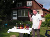 |
Делают домашнее вино из черники, черной смородины, морошки, дубовых листьев, березового сока, клубники, крыжовника, яблок, клюквы, весенних первоцветов и еще 20 других видов сырья. Хозяин предлагает дегустацию, показывает и рассказывает о процессе виноделия. Дегустация и покупка вин. |
|
 |
Кестери – родной дом деятеля ливской культуры и органиста Карлиса Сталте
(1870 -1947).
|
|
 |
Находится в восстановленном комплексе господской усадьбы «Смуку муйжас» (с XVI века). Летом можно трапезничать на террасе гостевого дома «Зиргу Сталлис», а в зимние месяцы – в баре у камина. Латышская кухня: «Полдник курземчан» (молочный суп с клецками и копченым салом), жареная на углях селедка, слойка из черного хлеба с взбитыми сливками, «Молочный колобок на деревенский лад» (парное молоко, сахар, корица, соус из садовых ягод), сырный картофель с жареной в меде свиной поджаркой. |
|
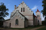 |
Стоит в городище Бейдас – на самом верху крутого склона долины Тебры (запружена Мельничным прудом). Церковь построена в городище куршей, где стояла укрепленная деревянная крепость Бейда древней земли куршей Бандавы. Первые сведения о храме относятся ко второй половине XIII века. Церковь неоднократно восстанавливалась и перестраивалась. Теперешний облик (готика) церковь приобрела во время перестройки в 1860 году и после того, как в 1730 году возвели башню. Это одна из старших церквей Курземе. До XVI века она была католическая, позже перешла в собственность лютеранского прихода. В церкви находится орган (1904 г.) фирмы «Зауэр», алтарь (вторая половина XIX века), надгробнаяплитаепископа Курляндского Х. Базедова (XVI в.), колокол (1589 г.) и др. |
|
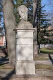 |
В 1877 году, отдавая дань заслугам предков в создании Нейбаде, барон Август фон Пистолкорс велел соорудить в парке памятник. После Первой мировой войны, в 30-е годы, памятник случайно был обнаружен при очистке русла реки Кишупе. Общество помощи и благоустройства Нейбаде памятник восстанавливает и в 1933 году его заново открывают. Памятник пострадал и после Второй мировой войны. В настоящее время памятник восстановлен и находится в парке эстрады. |
|


