
Природные объекты в Литве
Что особенного в природе в Литве?
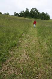
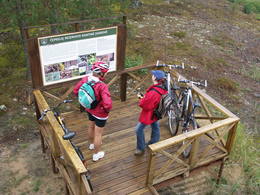
Куршская коса - песчаный, пустынный участок земли между Балтийским морем и Куршским заливом, холмистые ландшафты Жемайтийского региона, голубые зеркальные лабиринты озер в Аукштайтийском регионе, сосновые леса в Дзукийском регионе, Изгибы долины реки Немана и многочисленные региональные природные парки, созданные не только для защиты природы, но и для отдыха и интереса людей - это природные ценности, привлекающие гостей Литвы.
Действуй ответственно - следуй Зеленому совету!
| Обзор | Подробности |
|---|---|
 |
Литва
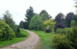
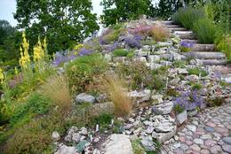
БОТАНИЧЕСКИЙ ОГОРОД ИМ. ТРАУПИСАЕдинственный в Литве школьный ботанический огород был заложен в 1989 г. в Школе им. Трауписа. Все коллекции растений (в целом здесь произрастает уже более 8000 видов, форм и сортов) были собраны одним человеком – С. Обелявичюсом. 
 4-9 4-9


Услуги
4-9 Месяцы активного сезонаСервисы - другие
Принимаются туристические группы
Принимаются индивидуальные посетители
Место с конкретным временем работы, которое следует уточнить заранее
Посещение по предварительной заявке |
 |
Литва
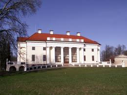
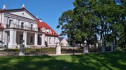
ПАРК УСАДЬБЫ БИРЖУВЕНАЙПарк находится в главной части усадьбы Биржувенай, на подступах к господскому дому. Для создания парка был использован рельеф долины реки Вирвите, а под парковые пруды была отведена старица реки. Для центральной части парка характерны черты регулярной планировки, тогда как остальная часть отличается пейзажным стилем. В партере напротив дворца стоит скульптура в античном стиле, а на западной окраине — деревянная беседка. В парке преобладают местные породы деревьев. Из интродуцированных растений здесь произрастают лиственница европейская, клен полевой, туя западная. На берегу реки выделяется группа дубов, а в центральной части — аллея из сердцевидных лип, ведущая до пруда по направлению к дворцу. 1-12
Услуги
1-12 Месяцы активного сезонаСервисы - другие
Принимаются индивидуальные посетители
Принимаются туристические группы
Место с конкретным временем работы, которое следует уточнить заранее |
 |
Литва
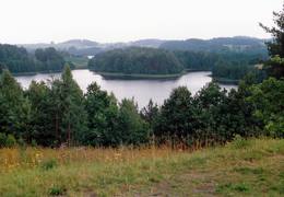
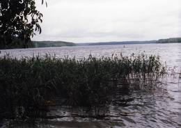
The Zemaitija National ParkThis park is located in the northern part of the Žemaitija Highlands, and much of it is taken up by Lake Plateliai. The park was established to protect lakes, rivers, wetlands and forest ecosystems, as well as the local cultural environment.
УслугиСервисы - отдых
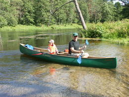
Прогулка на кораблике/лодкеTake a boat to the Pilies island in Lake Plateliai. 
ВеломаршрутBike around the lake (~25 km). 
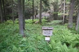
Природная тропаHike the Šierė nature trail (4.1 km), the Plokštinė information trail (3.1 km), which runs past a former Soviet military base, or the Mikytai information trail (1 km). 
Наблюдение за природойLook for birds from a tower near Lake Maudutis in the village of Virkšai. A viewing location from the village of Plateliai offering a look at the lake. There’s a visitor centre in Plateliai, as well. For more information: www.zemaitijosnp.lt (available in English). |
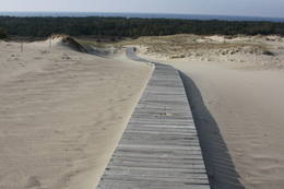 |
Литва
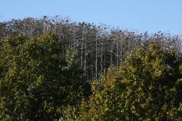
The Dunes of Courland National ParkThis is the only place in the Baltic States where there is such a vast territory of open-air sand dunes which still change the local terrain very actively because of the wind. The only Sea Museum and Dolphinarium in the Baltic States can be found here.
Услуги
325km - Расстояние от столицыСервисы - отдых
ВеломаршрутYou can bike from Nida to Smiltynė (>50 km along a bike route).
Природная тропаHike the Raganu Hill trail (1.6 km), the Naglių pathway in the sandy area of the nature reserve (~1.5 km), or the Parnidžio dune information trail (~2 km).
Наблюдение за природойWatch for birds on Garnių Hill and throughout the area during migration season. Views from the Naglių and Parnidžio dunes, as well as from the Hageno and Miškos galva dunes. For more information: www.nerija.lt (available in English). |
 |
Литва
ДУБРАВСКИЙ ДЕНДРАРИЙДубравский дендрарий был заложен в 1958 г. на базе Дубравской лесной научно-исследовательской станции, неподалеку от деревни Вайшвидава, что под Каунасом. Сотрудники дендрария собирают, хранят и экспонируют ценные с научной, познавательной и декоративной точки зрения растения местной и привозной дендрофлоры. Дендрарий занимает около 50 га. В нем растет более 800 видов, подвидов, вариететов (дикорастущих разновидностей) и культиваров (вариантов неизвестных в природе и искусственно выращенных растений) арборифлоры. Некоторые разделы дендрария (коллекция хвойных и вересковых растений, интродукционно-карантинный питомник и экспозиция редких деревьев и кустарников) доступны для посещения только по предварительной договоренности. 1-12
Услуги
1-12 Месяцы активного сезонаСервисы - другие
Принимаются туристические группы
Принимаются индивидуальные посетители
Место с конкретным временем работы, которое следует уточнить заранее
Посещение по предварительной заявке |
 |
Литва
Hügel LadakalnisVermutlich ein heidnischer Hügel. Schöner Blick auf die 6 Seenlandschaften. Ein Symbol vom Nationalpark. 122
Услуги
122km - Расстояние от столицы |
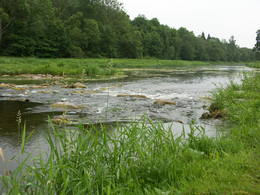 |
Литва
The Dubysa Regional ParkThis park was set up to protect the lovely ancient valley of the Dubysa River. This is one of the most popular rivers for water tourism in Lithuania, because it has a significant drop with rapids and beautiful shorelines.
УслугиСервисы - отдых
Прогулка на кораблике/лодкеA one-day boat trip from the Raseiniai-Baisogala road bridge to the Ariogala bridge. For more information: www.dubysa.info (very little information available in English). |
 |
Литва
Vilnius University Siauliai Academy Botanical GardenБотанический сад является подразделением Шяуляйского университета. Это самый молодой и самый небольшой по площади ботанический сад в Литве. Сад был заложен в 1958 г. Его общая площадь составляет 6,54 га.
3-10
Услуги
3-10 Месяцы активного сезонаСервисы - другие
Принимаются туристические группы
Принимаются индивидуальные посетители
Место с конкретным временем работы, которое следует уточнить заранее
Посещение по предварительной заявке |
 |
Литва
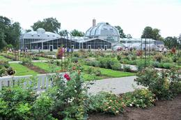
БОТАНИЧЕСКИЙ САД КАУНАССКОГО УНИВЕРСИТЕТА ИМ. ВИТАУТАСА ВЕЛИКОГОБотанический сад был основан в 1923 г. в качестве ботанического научного центра республиканского значения. Сад занимает более 60 га, а для свободного посещения открыты экспозиции общей площадью около 30 га.
4-10

Услуги
4-10 Месяцы активного сезонаСервисы - удобства
Запрещено брать с собой домашних животныхСервисы - другие
Принимаются туристические группы
Принимаются индивидуальные посетители
Место с конкретным временем работы, которое следует уточнить заранее
Посещение по предварительной заявке |
 |
Литва
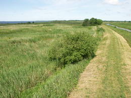
The Nemuna Delta Regional ParkThe Nemuna River divides up into two large streams at its estuary at Kuršių Marios, and this has established the Rusnė Island. This is a unique environmental territory with wetlands, streams, ancient rivers, lagoon lakes and flood plains which are important places for birds to nest and rest during migration season. Vast tracts of this territory are flooded each spring. The park includes the territory to the N and W of Rusne (lagoons, swamps, fishing ponds, Kuršių Marios).
Услуги
330km - Расстояние от столицыСервисы - отдых
ВеломаршрутBike the route Rusne-Pakalne-Uostadvaris-Rusne (20 km).
Природная тропаHike the Aukštumalos swamp information trail (1.7 km).
Наблюдение за природойBird watching on Rusnė Island, as well as at Ventės ragas (Cape Venta), where there is a bird ringing station. There is a viewing tower on the NW end of Rusnė Island, with a visitors centre in the village of Rusne. For more information: www.nemunodelta.lt (available in English). |
 |
Литва
БОТАНИЧЕСКИЙ САД КЛАЙПЕДСКОГО УНИВЕРСИТЕТАБотанический сад был основан в 1993 г. в живописной долине реки Дане. Он занимает около 9,3 га. В 2002 г. саду был присвоен статус дендрологического парка.
4-9
Услуги
4-9 Месяцы активного сезонаСервисы - другие
Принимаются индивидуальные посетители
Принимаются туристические группы
Место с конкретным временем работы, которое следует уточнить заранее
Посещение по предварительной заявке |
 |
Литва
Sarneles (Zviedru) pilskalns (Sarnelės (Svedų) piliakalnis)Viens no iespaidīgākajiem nacionālā parka pilskalniem, kura piekājē atradusies senpilsēta. Arheoloģisko izrakumu gaitā te atrastas kuršu senlietas. Tiesa, mežs un biezais augājs traucē uztvert šī nozīmīgā arheoloģijas pieminekļa patiesos apjomus un formu. Uz pilskalnu vasarās ved izpļauta taka. Ja esat Žemaišu Kalvarijas pusē un atliek brīvs brīdis, tad savā maršrutā var iekļaut arī šo apskates objektu. 317
Услуги
317km - Расстояние от столицы |
 |
Литва
Ula (Ula) un Merke (Merkys)Ūla ir viena no skaistākajām un likumsakarīgi – arī populārākajām Lietuvas ūdenstūristu upēm. Tās galvenā pievilcība ir skaistā ainava ar augstajiem upes krastiem, kuros slejas iespaidīgas smilšu kraujas līdzīgi kā Irbes krastos Latvijā. Laivošanu var sākt no Mančagires (Mančiagirė) vai Zervinos ciemiem un turpināt līdz Ūlas ietekai Merķē un tālāk pa Merķi līdz pat Merķinei un Nemunai. Ūla nav plata, taču posmā no Zervinos ciema tajā nav neviena koku aizgāzuma vai cita šķēršļa, kuram laiva būtu jānes apkārt. Ašā straume, asie līkumi, dzidrais ūdens un tajā redzamā zemūdens pasaule rada patiesi patīkamu sajūtu! Upes krastos atrodas gan publiskas (apsaimnieko Lietuvas valsts meži), gan privātas ūdenstūristu apmetnes un atpūtas vietas. Šī ir vienīgā Baltijas upe, kur ūdenstūristiem ir jāpērk licence. Ūlas krastos atrodas divi interesanti apskates objekti – Ūlas atsegums (Ūlos atodanga) un spēcīgs avots – Ūlas acs (Ūlos akis). Savukārt, Merķe jau ir jau krietni platāka upe, taču ar acīm redzamu straumi un dažviet pat jaukām straujtecēm. Kaut arī Merķes krasti ir mazapdzīvoti, tajos atradīsim piemērotas nakšņošanas vietas. Pa Ūlu un Merķi no Zervinos līdz Merķinei sanāk „mierīgs” pusotras - divas dienas ilgs brauciens. |
 |
Литва
Plokstines izzinas taka (Plokstinės pazintinis takas)Ja apskatīta kodolraķešu bāze, tad var iziet 3,2 km garo Ploštines izziņas taku, kas sākas turpat netālu. Taka ved cauri dažādiem mežu tipiem, iepazīstinot ar sikspārņu būrīšiem (cilvēka radītas sikspārņu dzīves vietas), apkaimes augiem un putniem, kā arī aizsargājamu dabas pieminekli – Pileļu avotu (Pilelio šaltinis). 302
Услуги
302km - Расстояние от столицы |
 |
Литва
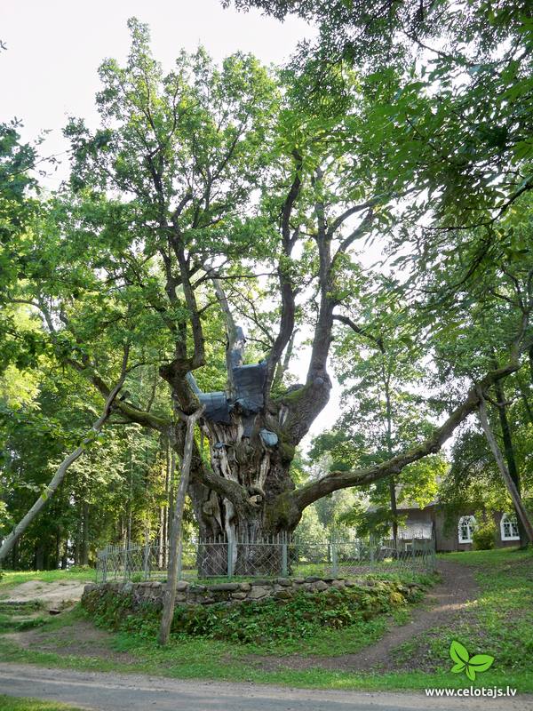
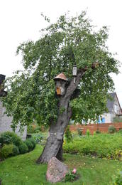
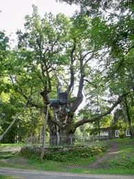
САМАЯ СТАРАЯ ЛИТОВСКАЯ ЯБЛОНЯСамая старая яблоня в Литве, плодовое дерево, представляющее собой ботанический объект природного наследия. Вид дерева: яблоня лесная. Это единственная яблоня в Литве, которая находится под охраной государства.
|
 |
Литва
ПАРК УСАДЬБЫ СТЕЛМУЖЕПарк усадьбы Стелмуже, что находится к югу от озера Стелмуже, был заложен в середине XVIII в. На холме здесь стоит костёл Креста Господня, к которому со всех сторон стекаются извилистые дорожки. Среди растительности преобладают липы, клены, дубы, вязы, березы, ели, ясени, сосны. У подножия холма можно найти Колодец счастья, прогуляться по дубовой аллее. Деревня Стелмуже также славится своим огромным дубом. Это самый старый и самый толстый дуб в Литве и одно из самых древних деревьев во всей Европе. Его возраст предположительно составляет 1500–2000 лет, в диаметре он достигает рекордных 3,5 м (чтобы обхватить его ствол, потребуется 8–9 человек), а его высота составляет 23 м. 1-12
Услуги
1-12 Месяцы активного сезонаСервисы - другие
Принимаются индивидуальные посетители
Принимаются туристические группы |
 |
Литва
УСАДЬБА СУРВИЛАСОВ ДЛЯ СЕЛЬСКОГО ТУРИЗМАНа хуторе Сурвиласов, что расположен неподалеку от деревни Швейцария Йонавского района, можно почувствовать природу всеми пятью органами чувств, ведь здесь есть необыкновенная тропа для прогулок босиком, на которой гостя ждут и шишки, и топь, и торф, и глина, и гравий, и шлифованное стекло, и хвоя, и солома, и полоса препятствий, и много чего еще. Протяженность тропы составляет более километра, благодаря чему босоногий путник получает всю гамму неизведанных доселе ощущений, положительных эмоций и наплыв энергии. 1-12

Услуги
1-12 Месяцы активного сезонаСервисы - удобства
Предлогают ночлегСервисы - другие
Принимаются туристические группы
Принимаются индивидуальные посетители
Место с конкретным временем работы, которое следует уточнить заранее
Посещение по предварительной заявке |
 |
Литва
Varniku izzinas taka (Varnikų pazintis takas)Varniku mežā (Varnikų miškas) ir izveidota patiesi interesanta dabas izziņas taka, kas iet cauri dažādiem biotopiem – skujkoku un ozolu mežiem, purvainu mežu un sūnu purvu ar akačiem un nelieliem purva ezeriņiem, kur uzceltas divas skatu platformas. Mitrajās vietās un purvā ir izveidotas koka laipas. Šī ir populāra pastaigu vieta. Taka ir lokveida un marķēta. Tās apskatei būs nepieciešama ~ pusotra stunda. |
 |
Литва
The Varniai Regional ParkIn the central part of the Žemaitija Highland, this park was established to protect local landscapes. Lithuania’s highest hillocks are found here – Mėdvegalis (235 m above sea level) and Šatrija (229 m). There are also other hillocks which offer a great view of the area – make up your own tour here.
УслугиСервисы - отдых
Природная тропаHike the Debesnos botany trail (2 km).
Наблюдение за природойViews from the Mėdvegalis, Šatrija, Moteraitis and Bilioniai castle hills. There’s a visitor centre at Varniai. For more information: www.varniai.lt (only in Lithuanian). |
 |
Литва
ПАРК УСАДЬБЫ ПАКРУОЙИСПейзажный парк усадьбы Пакруойис, чья структура сохранилась до наших дней, был разбит в 1850–1860 гг. С одной стороны естественную границу территории образует полоса запруженной реки Круойи, а с другой парк обнесен оградой из диких валунов. Согласно популярной в те времена английской схеме формирования парков преимущество отдавалось дикой природе и имитации естественности. В парке растет около 26 наименований деревьев, среди которых можно найти и редчайшие растения из различных уголков мира, привезенные сюда более сотни лет назад. 1-12

Услуги
1-12 Месяцы активного сезонаСервисы - удобства
Предлогают ночлегСервисы - другие
Принимаются индивидуальные посетители
Принимаются туристические группы
Место с конкретным временем работы, которое следует уточнить заранее
Посещение по предварительной заявке
Есть возможность заказать еду |
 |
Литва
Tauragns (Tauragnas)Ap 9,5 km garais un līdz kilometru platais ezers atrodas subglaciālā – t.i. ledāja veidotā vagā, tādēļ tas ir ne tikai Lietuvas, bet arī otrs Baltijas dziļākais ezers (pēc dažādiem avotiem 60,5 m vai 62,5 m). Tauragna dienvidu krastā paceļas Taurapils pilskalns (Taurapilio piliakalnis). Saglabājušies nostāsti gan par pagānu priesteri, kas te dzīvojis, gan nogrimušu baznīcu, gan laikiem, kad pilskalnu no visām pusēm apņēmis ūdens. No pilskalna plakuma paveras visaptverošs skats uz Tauragnu. 117
Услуги
117km - Расстояние от столицы |
 |
Литва
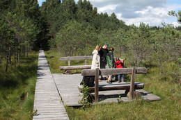
Botanikas takaKaut arī Augštaitijas nacionālo parku uzskata par floristiskā ziņā ļoti bagātu teritoriju, šī ir vienīgā vieta, kur varam iepazīt augu valsts bagātību. To īstenot palīdz takas malās izvietotie informācijas stendi. 3,8 km garās lokveida takas sākums ir meklējams Palūšē, Lūšu (Lūšiai) ezera galējā austrumu punktā. Taka ved gar ezera krastu, mežainām kāpām, nelielu strautu ielejām un pa purvāju. Nenomaldīties palīdz krāsu marķējums uz koku stumbriem. 113
Услуги
113km - Расстояние от столицы |
 |
Литва
ПАРК УСАДЬБЫ ИЛЬЗЕНБЕРГПарк усадьбы Ильзенберг отличается смешанной планировкой и сохранился в почти первозданном виде — таким, каким он был создан во второй половине XIX в. на живописном месте с выразительным рельефом, между озерами Апваласас и Ильгис. При восстановлении парка была сохранена его пространственная структура. Парк занимает 10 га и состоит из двух частей. Первая — это сравнительно правильная прямоугольная территория у дворца, ограниченная рядами сердцевидных лип и пейзажными группами местных и интродуцированных деревьев. Вторая часть представляет собой зеленые насаждения по типу естественного леса. Старый дуб из парка усадьбы Ильзенберг объявлен объектом природного наследия и находится под охраной государства. Охват ствола этого гиганта составляет 6,3 м, диаметр — 2 м, а высота — 30,5 м. 1-12
Услуги
1-12 Месяцы активного сезонаСервисы - удобства
Предлогают ночлегСервисы - другие
Принимаются туристические группы
Принимаются индивидуальные посетители
Место с конкретным временем работы, которое следует уточнить заранее
Есть возможность заказать еду |
 |
Литва
Garnu kalns (Garnių kalnas)Aiz Jodkrantes (Nidas virziens) ceļa labajā pusē ir izveidots autostāvlaukums un labiekārtota vieta, no kuras apskatāma Lietuvas (atrodamas ziņas, ka arī Eiropas) lielākā zivju gārņu Ardea cinerea un jūras kraukļu Phalacrocorax carbo kolonija, kur kopā varētu būt ~ 3000 putnu. Neaizmirstiet līdzi paņemt tālskati! 355
Услуги
355km - Расстояние от столицы |
 |
Литва
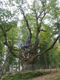
The Stelmuzės oak treeThis is the thickest English oak (Quercus robur) in Lithuania, with a circumference of 9.4 m (as opposed to the Kaive oak in Latvia, which has a circumference of 10.18 m).
|
 |
Литва
Bernsteinhaff1855, als einen Schiffahrtsweg getieft wurde, wurde im Haff unerwartet eine Bernsteinablagerung gefundet. In der Zeit zwischen 1860 und 1890 wurde dort 2250 Tonen Bernstein gewonnen, einbezogen einzigartige Bernsteingegenstände aus der Jungsteinzeit und der Bronsezeit. 319
Услуги
319km - Расстояние от столицы |
 |
Литва
Regionalpark GrazutėsGegründet für den Schutz der Landschaften und der Seen der Aukštaitija-Anhöhe, Arten und Biotope. 139
Услуги
139km - Расстояние от столицы |
 |
Литва
The Asveja Regional ParkThis park was established to protect Lithuania’s longest lake, Lake Asveja (> 20 km). The lake is in a sub-glacial valley carved out by ice during the Ice Age, and it actually resembles a wide and curvy river.
УслугиСервисы - отдых
Прогулка на кораблике/лодкеSpend one or two days boating on the lake and its bays.
Наблюдение за природойViews from the Dubingiai castle hill. For more information: www.asvejosparkas.lt (only in Lithuanian). |
 |
Литва
The Cepkelių Nature ParkThis is Lithuania’s largest mossy swamp, and the Čepkeliu Nature Reserve was established to protect it. Before visiting the swamp, you must register at the Dzūkijos National Park’s visitor centre (Marcinkonys, Šilagėlių gatve 11). УслугиСервисы - отдых
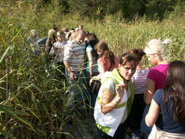
Природная тропаYou can hike or bike a sandy forest road from Marcinkonys (where the reserve has a museum) (~5 km), which will bring you to the western edge of the swamp. There’s a viewing tower atop a high dune, and from there you will be able to scan a broad territory. There’s a 1.5 km trail right there with a viewing platform atop the swamp. For more information: www.cepkeliai.lt (only in Lithuanian).
|
 |
Литва
ЖЕМАЙТИЙСКИЙ БОТАНИЧЕСКИЙ ПАРК ИМ. ИЗИДОРЮСА НАВИДАНСКАСАЭто один из первых ботанических парков в Литве. Парк заложил в 1928 г. Изидорас Навиданскас, которому тогда было всего 16 лет. В 1965 г. парк получил название Жемайтийского ботанического парка, а Изидорас вместе со своим сыном Раполасом, который в настоящее время является владельцем парка, продолжали расширять его.
1-12
Услуги
1-12 Месяцы активного сезонаСервисы - другие
Принимаются индивидуальные посетители
Принимаются туристические группы
Место с конкретным временем работы, которое следует уточнить заранее |


