
| No | Name | Description |
|---|---|---|
 |
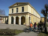
The second biggest city in Lithuania and from 1920 – 1939 - a temporary capital. The Old Town, The Town Hall (16th century), St. Peter and Pavil cathedral - basilica (15th century), Thunder building (15th century), Laisves alley, Ciurlionis Art and Devil Museum. |
|
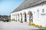 |
Located in the northern part of Valmiera, the Valmiermuiža Estate mansion (Neo-Baroque Style) was built between 1764 and 1771 by Prince August Friedrich of Schleswig, Holstein and Soderburg. Over the course of time it has been owned by other people. According to modern evidence, the mansion was a one-story building with a Baroque tower and a two-story addition in the early 20th century, which made it appropriate as a summer home and hunting lodge. The building burned down in 1918. Two years later, Valmiermuiža became a prison camp for captured soldiers. Later the addition to the mansion was restored and used as an elementary school. In 1936, the building became a prison, and it was once again a prison camp for captured soldiers during World War II. Later the building burned down again, and the ruins were removed. Still surviving is the Valmiermuiža tower, with ceiling paintings that are a cultural monument, as is the surrounding park. The Valmiermuiža brewery is alongside the historical monument, thus providing second wind for the whole region. |
|
 |
Old fishermen village, which was first mentioned in 1429. Before WW2 Juodkrante was popular resort in Europe and it still has its traditions nowadays. Village has an unique scenery with its wooden houses, promenade, Lutheran Church (1885), Lithuania's Art Museum Hall and much more. |
|
 |
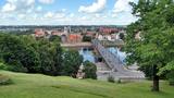
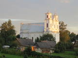
For the first time Valmiera is mentioned in the historical sources in 1323. Until the 13th century this place was in the composition of Talava, inhabited by Latgalians. Construction of Valmiera medieval castle began in the beginning of the 13th century, but in 1283, between the Gauja River and Rate River towered church. Location near to the Tartu-Pskov and Novgorod trade routes greatly facilitated the economic development of the populated area. During the 14th-16th century Valmiera was a part of the Hanseatic League. It suffered greatly from wars, epidemics and fires in 16th to 18th century. In the second half of the 19th century the economic boom started again. It was also facilitated by the building of wooden bridge across the Gauja in 1866 and Riga-Pskov railway opened in 1899. Historic centre is destroyed in 1944. During post-war years, large industrial companies such as - Valmiera glass fiber factory (to this day) are opeating in the town. Today, Valmiera is economic, educational and sports centre of Vidzeme. |
|
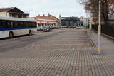 |
Ap 200 m garajā un izstieptās formas laukumā no 16. – 20. gs. atradās Liepājas tirgus. Laukuma malās tolaik bija izveidojusies vienstāvu apbūve – iebraucamās sētas, viesnīcas un dārzi. Līdz ar Pētertirgus izveidi 1910. gadā, izmainījās arī laukuma apveidi un to ieskaujošā apbūve. Laukuma DA malā slejas iespaidīgā Liepājas Svētās Annas Luterāņu baznīca. |
|
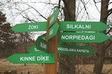 |
is seen as the newest village along the Livonian coastline. It was established during the 17th century. Košrags had 78 residents in 1826. The first reading school for Livonian children in the Dundaga seashore villages was opened at the Žoki homestead in 1832. One of the teachers was Nika Polmanis, who was the first Livonian to have completed a professional education. He also translated the Gospel of Matthew into the Eastern Livonian dialect. Košrags had a windmill, water mill and boat building facility. During the spring, job seekers from Saaremaa stopped here. A port was installed in 1932, and a breakwater to collect sea fertiliser followed in 1938. During the 1930s, Košrags was regularly visited by Finnish and Estonian linguists to study the folklore of the Livonians. The Norpiedagi homestead was built by Livonian activist Didriķis Volganskis (1884-1968). His son, Livonian cultural worker and pastor (in Finland) Edgars Vālgamā (Volganskis, 1912-2003) was born there. He translated the Andrejs Pumpurs epic "Lāčplēsis" into Finnish. Košrags today is a cultural monument of national importance. |
|
 |
Pilsētā nebija lielu rūpniecības uzņēmumu, un tās iedzīvotāji
nodarbojās galvenokārt ar amatniecību, tirdzniecību un lauksaimniecību.
Ilūkste tika pilnībā nopostīta 1. pasaules kara laikā un smagi cieta arī
2. pasaules kara laikā. Šodien Ilūkste ir klusa pierobežas mazpilsēta, ko
ieskauj gleznains dabas apvidus. Apskates objekti: bijušā jezuītu klostera ēka
un Ilūkstes katoļu baznīca.
|
|
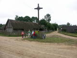 |
Ein der ethnografischen Dörfer in Dzūkija mit Holzgebäuden und Kruzifix. |
|
 |
Jurmala town (the second largest in Latvia) was founded in 1959, by combining Kemeri and Sloka towns in the Riga city Jurmala district. It stretches 32 km along the coastal line of Gulf of Riga. Jurmala resort once was one of the most important objects of this type in the Northern Europe. This was facilitated by the development of local and interstate transport and traffic (coaches, steamers, train). The first guests was accommodated in Dubulti, where in 1834 the first hotel was built, but in 1847 - The first wellness centre. In the 19th the first medical institution launched. Starting from 1834 the rapid construction of summer cottages began. Development of the resort was ended by the World War I. After the war the number of resort vacationers boomed from 12 thousand (in 1920) to 32 thousand (in 1935). Kemeri resort developed along with Jurmala, which received a massive of vacationers' amount during the Soviet period. |
|
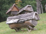 |
Das bekannteste Museum der Geschichte der Bienenzucht Litauens mit den Bienenhäusern verschidener Arte, der Arbeitsmittel der Bienenzüchter, Holzskulpturen und Hönigankauf. |
|
 |
The largest town in South-Eastern Latvia is on the banks of the Daugava River, which is the border between Latvia and Belarus at this location. The border runs down the middle of the river. Piedruja has two parts – Piedruja and Aleksandrova, which are separated by a central street (the V 631 road). Piedruja emerged from the Druja town that was on the left bank of the Daugava. During the 17th century, the two parts were owned by the Stapekha dynasty of Lithuanian aristocrats. It is worth strolling through the town, because the low-level wooden houses are reminiscent of buildings that are exhibited in open-air ethnographic museums. Piedruja is neat and tidy, with two churches and the Daugava rock that are part of a local hiking trails. Aleksandrova has a tourist accommodation, “Piedruja,” which offers special soirées in the Lettigalian, Russian and Belarusian style. Please be aware that you need a temporary permit to enter the border zone. The Border Guard facility is in Piedruja and at a place where there was a Daugava crossing point comparatively recently. |
|
|
|
Entstanden als eine 6 km entfernte Arbeiterstadt des schon geschlossenen Ignalina-Atomkraftwerks. In der Stadtbebauung dominieren die für die Sowjetzeit typischen architektonischen Formen und Monumentalbauten. |
|
 |
Saldus is mentioned in the historical documents already in 1253. Until the 13th century an ancient Cours castle Salden was located here, which is also represented in the coat of arms of the town. Around the 1341 Livonian Order built a castle near the Cours hill fort, where settlement formed. Its peak of development, like the other settlements of Courland, was during the reign of Duke Jacob 1642 – 1682. 1856 is mentioned as the year of the foundation of Saldus, when restoration of town perished during the Northern War begun. At the end of the World War II a big fights took place at the town, but town remained in German-occupied part of Latvian until the May 8, 1945. Modern Saldus attracts with its activities - town days, the music festival "Saldus Saule", as well as a variety of sightseeing objects, among which A/S 'Druvas Partika" can be mentioned, where you can watch how the ice cream is made and Saldus Food Factory, where you can taste the delicious candy "Gotina" and watch the production process. |
|
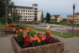 |
Madonas centrālais laukums, kas vēl 20. gs. sākumā bija tirgus laukums. Pēc apjomīgās restaurācijas tas ir kļuvis par ievērības cienīgu pilsētvides objektu. Laukuma ziemeļu pusē atrodas pilsētas un novada pašvaldība un Madonas novada TIC. |
|
|
|
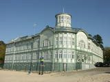
Hauptstadt von Hiiumaa. |
|
 |
Kemeri (Kemmer) are mentioned in the literature sources for the first time in 1561. In the second half of the 18th century and in the beginning of the 19th century the curative properties of Kemeri sulphur spring waters and swamp mud are well known, therefore here representatives of the highest Kurzeme social circles arrive for treatment. The local foresters welcome the guests. During this time the first mud baths are organised. For some time the development of Jurmala and Kemeri beach is terminated by the Fatherland War of 1812. Two decades later – from 1833 until 1835 the benefits of Kemeri were enjoyed by General Governor of the Baltics Graf K. M. Palen, who addresses the Tsar of Russia Nicholas I for supporting further development of the health resort. Plead is supported and in 1836 Tsar allocates 700 ha of state land and grants 100 000 roubles for the construction of sanatorium and paving of the road from Kemeri till Sloka-Tukums high-way. Two years later (in 1938) the first state bath institution is opened. This is also considered the year of founding the health resort. In several stages the formation of Kemeri Landscape Park is begun, which is an important part of the health resort. In the middle and second half of the 19th century further development of the health resort is promoted by steamboat, as well as railroad traffic that are opened in 1877 from Riga till Tukums. In 1912 direct railroad line Kemeri-Moscow is opened. Early before World War I the number of patients reaches 8300 per year. The 1st battlefront of World War I is held in Kemeri swamp for several years and the health resort is significantly destroyed. Despite this fact after the war it develops rapidly and Kemeri becomes a beloved recreation place for the residents of Riga and one of the most modern health resorts in Europe. In 1924 a new bath institution with mud-baths is built in Kemeri, which at the time is one of the most modern in Europe, but in 1936 State President Kārlis Ulmanis opens one of the most prominent buildings of the first independent state of Latvia period – hotel "Ķemeri". Also after World War II – during the Soviet times the health resort is significantly expanded and almost 10 sanatoriums are established within its territory, in which about 100 doctors are employed. In 1971 Kemeri is awarded the status of All-Union health resort. From 1975 until 1985 the largest of sanatoriums is constructed in Kemeri – Līva (initially – Latvija), which has two blocks of eleven storeys. Up to 1200 patients at the same time could receive treatment at Līva, but within a year – up to 140 000 patients. The sanatorium is closed in the beginning of the 90ies of the 20th century as unprofitable. Up to 1994 five sanatoriums operate in Kemeri: "Čaika", "Daugava", "Dzimtene", "Ķemeri" and "Līva" (Latvija) and resort policlinic "Ķemeri". The latter period may be considered the declining fame period of Kemeri as a large-scale health resort. |
|
|
|
Ein einzigartiges Örtchen beiderseits des Flusses Minija, wo der Fluss eine „Hauptstraße” ist. Litauens Venedig. |
|
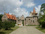 |
Cesvaine was first mentioned in written sources in 1209. For each traveller in Latvia, the town is associated with the family of Baron Woolf, who bought the Cesvaine estate in 1815. Cesvaine experienced the economic boom after establishment of Plavinas Gulbene railway. Town suffered significantly during the World War II. At the end of 2002, the Cesvaine Castle was struck by the tragedy - a fire, which damaged most of the castle. Cesvaine Castle is "recovering" by means of large public, state and local government support and still keeps the status as a significant tourism attraction in a scale of Vidzeme and Latvia. |
|
 |
This is an urban construction monument that was created between the 17th and 19th century, and it is of national importance. The street layout around Jelgavas and Rātūža streets forms closed blocks of buildings. There are Lutheran, Catholic, Orthodox and Baptist churches in Jaunjelgava. One of the most outstanding architectural monuments is City Hall, which was built in 1912 and features Art Nouveau forms. None of the city’s five synagogues has survived. The historical centre of Jaunjelgava features a promenade that runs along the banks of the Daugava River. This is a popular place for strolls, leisure and swimming. |
|
 |
From the 6th century until the 8th century instead of the current Grobina the largest known Scandinavian trade and warrior colony in the Baltic States was located. Settlers from the inlands of Gotland and Sweden established their settlement at the hillock that was then located at the bank of the navigable Alande River. It is believed that the Cours Castle – Seeburg mentioned in the chronicles of the 9th century was located exactly here. After the loss of the order castle in the 13th century Grobina became the centre of the region. The most ancient construction of the city was formed around Lielā Street, as well as around Saules and Parka Streets. |
|
