
| No | Name | Description |
|---|---|---|
 |
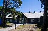
Saimniecība "Dižgāļi" Alsungā nodarbojas ar bioloģisko lauksaimniecību, gaļas liellopu audzēšanu un aitu audzēšanu. Apmeklētājiem ir iespēja aplūkot saimniecību, tajā esošos dzīvniekus, kā arī iegādāties svaigo produkciju. Saimniece pastāstīs par vietas vēsturi, kā arī pacienās viesus ar vistas zupu. |
|
 |
Alūksnes novada saimniecībā "Pauguri" kokamatnieks Jānis Vīksne izgatavo koka virpojumus - cibiņas, pulksteņus, pildspalvas, spēles, šūpoles un citas saimniecībā noderīgas lietas. Iespējams iegādāties kokamatniecības suvenīrus - dekoratīvus un praktiskus virpojumus no koka. Senlietu muzeja apskate - seni galdniecības darba galdi, ēveles, āmuri, sirpji, grābekļi, sējmašīna, pulksteņi, trauki u.c. Saimniecībā ir izveidota skatu platforma, no kuras paveras skats uz Hānjas augstienes ainavām Igaunijā, kā arī atpūtas vieta vasaras piknikam ar galdu, uguskura vietu un skulptūrām. |
|
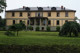 |
The origins of the castle that was built in the style of Classicism date back to 1784. Later it was rebuilt into a two-story building with a portico with four columns at its centre. A new period in the development of the state began in 1993, when restoration of the buildings began. The estate currently houses a children’s village, while the mansion is now a hotel.
|
|
 |
Ap 400m garš un līdz 16m augusts atsegums upes kreisajā krastā.
|
|
 |
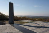
The so-called Christmas battles between the Russian and the German military took place in 1916, during World War I. Latvian riflemen demonstrated such courage and heroism during these battles that they became known far beyond Latvia’s borders. Machine Gun Hill now has a memorial to the Latvian riflemen. The viewing tower on the hill has been restored. The Maztīrelis swamp and the place where the German narrow-gauge railroad used to run can be seen well from the hill. The rail tracks crossed the swamp from the North to the South, and the rows of trees in the swamp show where they were.
Visiting the object: You can hike the area with or without a guide. The Christmas battle museum at the Mangaļi homestead offers thematic and educational events, as well as mock battles. You can look at monuments, graves, trenches, fortifications, dugouts, etc.
The Mangaļi homestead is home to Latvia’s largest mock-up of a battle site. There are unique elements of fortifications from World War I here – ones that are related to the Christmas battles. One part of the fortifications has been reconstructed in its original location – the dugout and a part of the so-called “German rampart” that was part of the front line of the German fortifications.
|
|
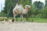 |
A park of exotic animals in Dundaga features alpacas, llamas, ostriches, a camel, a blue cow, etc. |
|
 |
The Old Town of Kandava is located around the old Market Square and dates back to 1881, after a fire in the town. The urban environment in Kandava is made up of farms with various buildings, closed yards, passageways and walls made of fieldstones. These can be seen in Talsu Street and Sabiles Street. Uncommon for Latvia is Lielā Street. At the foot of the Bruņinieku Castle Hill is a model of the Castle of the Livonian Order that was created in 2010. |
|
|
|
Eine der malerischischen Burgberge am Fluss Nemunas mit schöner Sicht aufs Flusstal. In 13 – 14 Jh. befand sich hier eine militäre Festung, die nicht erhalten ist. |
|
 |
In der Umgebung von der 52 m hohen Parniddenen Düne sind die im 18. Jh. bei einem Holzeinschlag entstandene Wanderdünen zu sehen! Aussichtsplatz. |
|
 |
"Karpyne" has an excellent restaurant which offers both various fish dishes as well as other foods. Here there's a lot to do inside and outside, for example, inside is bowling alley, swimming pool, gym and outside - outdoor swimming pool and a tennis court, there's a possibility to fish too. Seminars and celebrations can be organised here. |
|
 |
Atpūtas centrā tiek piedāvāta iespēja atpūsties brīvā dabā kolektīviem vai individuāliem apmeklētājiem. Iespējams izmēģināt dažādus metamos ieročus (nažus, cirvjus u.c.), kā arī šaušanu ar dažāda veida lokiem, arbaletiem, pneimatiku u.c. |
|
 |
Home restaurant on Kihnu Island, where owners make rich meals, using the island's local ingredients, mainly fish. |
|
 |
Construction of the Neibāde resort in 1823, started up hospitality traditions. The park, designed in an English style, was created by the gardener Akerbergs, who was brought from Estonia by Baron August von Pistohlkors. In the 1920s – 1930s the Pēterupe – Neibāde Seashore Aid and Improvement Society looked after the restoration and care of the monument and the park of the resort that was ruined during the war, the appearance of Saulkrasti, the organisation of different events and foundation of the theatre and the choir, led by Olga Cīrule. Saulkrasti open-air stage has always been a place for festivities. 16 July 1933 is a date that deserves special attention as it was on this date that the open-air stage became the place where Neibāde and Pēterupe were renamed Saulkrasti. The open-air stage was repeatedly rebuilt and improved. Both during the Soviet era, as well as later, this was a meeting place for locals on joyful moments, on moments of change and remembrance. The stage was the place of origin of the Popular Front of Latvia (Latvijas Tautas fronte) Saulkrasti branch. Now the stage is a meeting place and holds different events on summer weekends. Each year Saulkrasti town festival concert takes place on this open-air stage. |
|
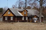 |
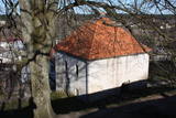
This set of buildings represents a homestead for a fisherman and a farmer. The house was built in 1926, and the ancillary buildings all date back to the first half of the 20th century. The homestead can be seen from the road. |
|
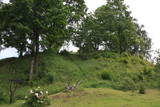 |
Atrodas 0,3 km ziemeļos no Vecpiebalgas pilsdrupām. Ap 10 m augsto, bet visnotaļ izteiksmīgo Grišku kalnu sauc arī par Piebalgas, Balgas un Veļķu pilskalnu. 13. gs. šeit bijusi svarīga apmetnes vieta ar mākslīgi nostāvinātām nogāzēm un dziļu aizsarggrāvi. Vēstures notikumi ir atstājuši ap metru biezu kultūrslāni. Bezlapu laikā no kalna paveras skats uz Vecpiebalgas baznīcu un pilsdrupu vietu. Pilskalna piekājē ir aka ar Griškavotu. |
|
 |
Livonian Community House at Kolka was opened in 2019. It is a place where you can get to know the Livonian culture of Northern Kurzeme, learn about traditional activities, listen to the sound of the language, and get an idea of the cultural and historical heritage of the coast. In House you can organize and attend cultural events, seminars, trainings, exhibitions, and also receive tourism information. |
|
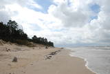 |
Бернати - самая западная точка суши Латвии. Рядом с автостоянкой установлен каменный знак скульптора Вилниса Титанса «Зеленый луч» (1998 г.). Бернатский мыс подвержен воздействию ветра и волн, поэтому здесь наблюдается вымывание морского берега. У дороги, которая из центра поселка Бернати ведет к морю, в конце дюн (имеется указатель), установлен памятный камень со словами первого Президента Латвии Яниса Чаксте, сказанными в 1924 году: «Здесь должен быть курорт». |
|
 |
The craftsman produces bespoke and elegant interior design objects such as wooden furniture (closets, beds), stairs and other useful items. He will be happy to share his knowledge and experience. Among other things, Andris Prikulis has built several wooden altars for churches. |
|
 |
Relatīvi grūti pieejama un cilvēka mazskarta teritorija kūdrā izstrādātajā Cenas tīreļa ziemeļaustrumu daļā, kur saglabājušies augstā purva biotopi ar purva ezeriem, kas kopumā veido nozīmīgu vietu ligzdojošām un migrējošām zosveidīgo, tārtiņveidīgo u.c. putnu sugām. Teritorija nav piemērota (un nav vēlams) tūrisma aktivitātēm.
|
|
 |
Located in the Līva Hotel in Old Liepāja, the restaurant offers Latvian and global cuisine. It has an herb garden to produce ingredients for the dishes. Latvian cuisine: Low-salt herring with cottage cheese, stuffed crepes, potato pancakes, sautéed pork ribs, venison with juniper berries, roast leg of duck, roast filet of pike-perch with grits, smoked herring filet. Special foods: Smoked cod with potatoes, onions and dill in a ceramic ramekin. |
|


