
| No | Name | Description |
|---|---|---|
 |
Saimniecības pamatnodarbošanās ir diļļu audzēšana un to pārstrāde. Siltumnīcā audzē arī Itālijas dienvidos zināmu melones un gurķa krustojumu "Carosello", kas latviski nodēvēts par "pūkaino gurķi". Iespējamas degustācijas, kā arī saimniecības produkcijas iegāde. |
|
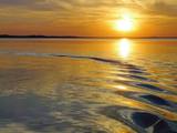 |
Lake Rāzna (57,8 m2) is often called the sea of Latgale. It is the biggest lake in Latvia. Rāzna is situated
on the hill Rāznava. You should see beautiful landscapes, high peaks and Latgalian castle hills. Enjoy the
recreation places beside the lake, the National park of Rāzna and its surroundings. The place is included in
the European Union network of protected areas NATURA 2000. The lake has 10 islands and two gulfs. The
level of the water reaches 163.8m.
|
|
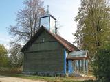 |
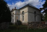
Pļuskovas Old-Believer Preaching House was built in the beginning
of the 20th century
|
|
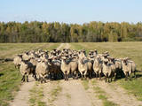 |
The farm, which has been developed around the servants’ home of the former Ķempēni Estate, breeds more than 200 Latvian dark-headed sheep. Visitors can purchase meat, wool and skins, also taking part in informational tours with tastings of various foods, as well as catching and tasting trout (this is available only to those who spend the night at the venue). |
|
 |
Visitors to the brewery can learn how beer is brewed and taste the beers and mead drinks that are produced there. |
|
 |
The restored mansion of the Dunte Estate is now a museum featuring the adventures and life of the legendary king of lies, Baron Munchhausen. The first floor is devoted to the barn and his stories, while the second floor has a collection of wax models of people who are distinguished in terms of Latvia’s history. Also there is the largest collection of beer mugs in Latvia. There are three circular trails in the forest with wooden sculptures. The longest one leads to the sea. A wooden model of a ship is interesting to children. |
|
 |
This park surrounds the mansion of the Biržuvenai Estate, and it is based on the terrain of the Virvite River and an old river that provides water for the park. The central part of the park is regularly designed, while the rest has elements of landscape. Opposite the estate is a glass sculpture, and on its western side is a wooden pergola. Local trees dominate in the park, but there are also trees from other countries. Of importance is a group of oak trees on the banks of the river, as is an alley of linden trees that leads to the pond in the direction of the estate. |
|
 |
Celta 1933. g. vietējai brāļu draudzei. Baznīcā atrodas glezna “Kristus” (1850. g.) un Liepājas meistara Jēkaba Jauģieša 1920. g. darinātās ērģeles. Mūsdienās dievnamu izmanto Bārtas draudze. Pie baznīcas novietots akmens apkaimes represētajiem iedzīvotājiem. |
|
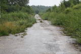 |
One of the largest tank bases in the Baltic War District was located during Soviet times just South of Gardene. The territory has largely been abandoned, and there are just a few remnants of the buildings that were once there. If you drive down the Dobele-Annenieki road, you will find a paved military road splitting off from it. It is still used today. The buildings and urban planning of Gardene are also of interest – during the Soviet era, soldiers and their families lived there.
|
|
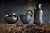 |
The potter uses the black (smoke) technique to create his artworks, and he uses clay from Latgale. He uses no industrial equipment in his work, and the kiln is fired with firewood. You can watch as he creates dishware on a foot-powered potter’s wheel and talks about the firing process. You can work with clay and purchase finished products. |
|
 |
Traķu pirmsākumi ir meklējami Senajos Traķos, kas atrodas 4 km dienvidaustrumos no Traķu centra. Uzskata, ka Senos Traķus ir dibinājis Lietuvas dižkunigaitis Ģedimins (~ 1275. – 1341.) 14. gs. pirmajā pusē. 14. gs. otrajā pusē šeit uzcēla mūra pili, no kuras līdz mūsdienām ir saglabājušies tikai nostāvināti zemes vaļņi. Laikā no 1345. – 1382. g. tajā valdīja Ģedimina dēls – Ķēstutis (1297. – 1382.). Senajos Traķos dzimis arī viens no izcilākajiem viduslaiku Lietuvas valdniekiem – Ķēstuta dēls - Vītauts Dižais. Kā pilij, tā arī tās valdniekiem bija nozīmīga loma sekojošajos krusta karos un cīņās. 1391. g. pils tika sagrauta cīņas laikā ar Vācu ordeni, kādēļ arī zaudēja savu stratēģisko nozīmi. 1405. g. benediktīniešu mūki šajā vietā uzcēla baznīcu, bet 18. gs. beigās - jaunu un lielāka apjoma klosteri, kura vienu no korpusiem 1889. g. pārbūvēja par baznīcu. |
|
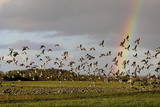 |
This is one of the most popular bird-watching locations in Estonia, and during spring and autumn migration there are a great many different kinds of birds resting and feeding in the meadows and shallow coastal waters of the Bay of Matsalu and the Kasari River.
|
|
 |
Atrodas Lielajā ielā 34 a. Vēlīnā klasicisma stilā celtā baznīca pēc muižnieka Nikolausa fon Korfa ierosmes būvēta laikā no 1828. - 1830. gadam. Dievnams ir interesants ar to, ka tajā apskatāms Vidzemes sakrālmākslā rets altāra tips – kancelaltāris (kancele un altāris ir apvienoti arhitektoniski vienotā mākslinieciskā kompozīcijā). |
|
 |
The Krustkalni Nature Reserve was established in 1977, and the diversity of plants in the region is based both on the terrain – the Madona-Trepe embankment, a series of hillocks with low areas among them, swamps and small lakes – and on the biotope – natural meadows, forest glades, places where underground streams bubble up to the surface, and vast areas of forest with very old stands of trees. Some 800 types of plants have been defined in the reserve. It can be toured only in the company of a guide from reserve headquarters, and one must apply in advance. Visitors can visit the Krāku streams, Lake Svēte-Dreimaņi, and other sites. |
|
 |
Temple Hill is steep (with artificially created steepness) and about 30 m high, and it is opposite Marijas Island. It is an ancient Lettigalian castle hill, 80 m long and 40 m wide, with several artificial ramparts. One of the oldest objects found in the region is an axe from the 2nd to 3rd millennium BC. Archaeologists believe that the island was populated at that time. There was a Lettigalian castle on the hill during the 10th and 11th century, but it was sacked by the Holy Crusade. The surface of the castle hill was transformed comparatively recently in 1807, when a granite rotunda was built there in honour of Russian Field Marshall Sheremetev and Swedish captain Wulff. The view of Lake Alūksne and the town is one of the most beautiful ones in all Vidzeme. The Sun Bridge (1937) is also worth a look. A wooden viewing platform is nearby. |
|
 |
Ezeres kultūrvēstures un novadpētniecības materiālu krātuve “Muitas nams” ir izveidota vēsturiski nozīmīgā ēkā, kur, II pasaules kara noslēgumam tuvojoties, 1945. gada 8. maijā tika parakstīts Kurzemes katlā ielenkto vācu karaspēka daļu kapitulācijas akts. Ar to tiek uzskatīts, ka Ezerē faktiski beidzies II pasaules karš. Krātuves materiālu ekspozīcijas ir no Ezeres pagasta senvēstures līdz šodienai, tai skaitā ezernieku vaļasprieki. |
|
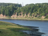 |
In Aizkraukle, drive down Enerģētiķu Street to the Selonian side (there will be small “pockets” at the side of the road) to see one of the best views of the Daugava River valley, reminding us of what this fateful river was like before the power plant was built. You will see that the river has eroded the steep cliffs on the right bank. The further part of the valley is part of the Daugava Nature Park.
|
|
 |
The cafe is situated in Stende, approximately 12 km away from Talsi. |
|
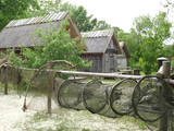 |
This is a very interesting monument to the history of fishing in the region. These areas had docks and areas where fishermen built huts to store their nets and other inventory. The areas also had a social role – men came together to discuss work that had to be done, while women and children wove nets. The huts at Bigauņciems were eventually washed into the sea, and the areas at Ragaciems have been partly destroyed. The ones at Lapmežciems are the ones which are best preserved. One of the net huts has been restored, but the others are in very poor condition, indeed. That may be why you should focus on these huts as you walk along the beach. Make sure that you take some pictures of this historic location. |
|
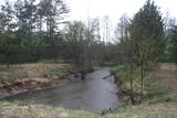 |
Nature restricted area is located to the South from former railroad Ventspils-Liepaja and includes approximately 6 km of Uzava River (and the old drainage system). The territory was used for agriculture during Soviet time, now it starts overgrow by scrubs. The protected nature values – rare bird species, including corncrakes, variety of grassland habitats and plant species. Territory is not useable for tourism activities. There is a possibility to get good insight into the North part of restricted area from the road Alsunga – Berzkalns where information stand is located.
|
|


