
| No | Name | Description |
|---|---|---|
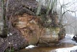 |
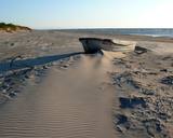
It is worth hiking this road where in crosses the Šlītere Blue Hills. This part of the road is approximately one kilometre long, and it goes down to the valley of the stream which crosses the hills. The place has been given a peculiar name – the Kušperlankgrāvis ravine (or the Zeltiņi ravine, as is claimed in other sources). If you're driving, be careful, because there is no bridge here, just a ford. During the early spring or the winter, you will appreciate the ravines and the impressive Blue Hills themselves. Impressive sandstone cliffs which are several metres high and have been vandalised by human hands are on both sides of the road. There is a small niche in one of the cliffs. To the right (East) from the road at the terrace of the Blue Hills is a side road which leads to the Mežlīdumi homestead. Please be gentle with the cliffs! |
|
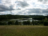 |
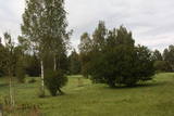
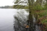
Ilziņš jeb Vestienas dzirnavezers pazīstams ar nostāstiem par tajā "periodiski uzpeldošām kūdras salām". Saskaņā ar vietējo iedzīvotāju sniegtajām ziņām, minētā parādība gan sen jau vairs nav novērota. Tajā pat laikā ezers un tā apkārtne ir nozīmīga daudzu aizsargājamu biotopu un sugu dzīves vieta. Ezers ietilpst Vestienas aizsargājamo ainavu apvidū. Ezeru var redzēt, braucot pa Ērgļu - Gaiziņkalna ceļu. Var pakāpties arī blakus esošajā paugurā (ziemeļos no minētā ceļa un ezera), no kura paveras plašāka skatu perspektīva.
|
|
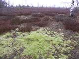 |
Baltijas mērogā unikāls dabas un cilvēkizmantots apvidus, kas veidojies kādreiz - padomju, mūsdienās - Latvijas Nacionālo bruņoto spēku pārvaldītā armijas poligona teritorijā. Poligona lielāko daļu aizņem smilšains vai ar zemiem lakstaugiem un krūmāju apaudzis kāpu masīvs ar atsevišķiem lielākiem kāpu vaļņiem. Rudens laikā šeit lielās platībās zied virši. Unikālā virsāju un aprimušo kāpu ainava un daudzu sugu dzīves vieta bija daži no iemesliem, kādēļ šai militārai teritorijai ir piešķirts arī aizsargājamas dabas teritorijas statuss. Jāatgādina, ka poligona apmeklējumi privātpersonām bez iepriekšēja saskaņojuma ir aizliegti!
|
|
 |
Neskartu mežu cienītāji var doties izpētīt Plakanciema puses mežu takas. Braucot no Plakanciema pasta nodaļas Mellupu virzienā pa autoceļu V7, pēc aptuveni 1 km jānogriežas ceļā pa labi. Tālāk jādodas uz priekšu vēl 1,2 km. Maršruta sākums - iepretī mājām “Putriņas” ceļa kreisajā pusē, kur sākas meža ceļš. Sākumā maršruts ved pa taisnu meža ceļu. Pēc 500 m nonākam pie ūdenskrātuves (karjera). Šeit ir iespēja doties vai nu gar vienu ūdenskrātuves krastu, vai gar otru. Abās pusēs var aiziet aptuveni līdz ūdenskrātuves pusei un tad griezties atpakaļ. Krastā augošos kokus iecienījuši bebri. Ūdenī peldas pīles, meža ceļa malā vairāki skudrupūžņi, no sakritušo pērno lapu apakšas lien ārā zaķskābenes. |
|
 |
Work on the arboretum, which covers 15 hectares of land, began in 1968, and it was meant to be a landscape park. The first plants were planted in 1972. During the fierce winter of 1976, sadly, many of the plants froze. In 1987, the park was redesigned. At that time it had 234 types of deciduous trees, coniferous trees and bushes. There are signs showing the Latin and Latvian names of the various plants
|
|
 |
This is a swamp into which sulphurous waters flow, and it is on the left bank of the Abava River valley. This is the only place in Latvia where the protected shrubby cinquefoil is found in the wild. This bush covers approximately one-fifth of the restricted territory. It also includes forests, various kinds of meadows and sulphurous streams, including the one which is known as the Devil’s Eye. |
|
 |
The castle hill of Rasnupļi (Opiņķi) is a significant place on the foot of the hill inhabited by ancient Latgalians.
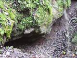
You will notice Velna ala (Devil’s cave) also called small Staburags of Latgale (ancient cult place)
in the right side of the Vīce river. It is a small natural geologically unique formation (length – 3m, width –
2m, high – 0,6m). There are only two such caves in Latvia. There are 5 – 6 m long stalactites.
|
|
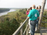 |
The old wooden tower at this site was torn down and replaced with the one that is there now. The restored tower offers one of the loveliest views in Eastern Latvia – one of the eight curves of the Daugava. This is the Rozališki curve. Here you will get a whole new sense of the Daugava River and its mighty valley in a place where the waters of a hydroelectric plant bubble away in our present day and age. It is claimed that the scene that is seen on the 10 lats note is based on the view which can be seen to the West from the tower. |
|
 |
"Valgums" is a word referring to the sandy coastline zone between dunes and water, and once there were boats and nets that were being dried at this location. Each village had several areas of this type, and in the 1920s and 1930s, these were of great importance in the preservation of the Liv language. |
|
 |
This trail offers education about the forest for children of all ages, families with children, and friends of the environment. The trail is located in the Īle Parish of the Auce Administrative District, 2 km from the Pokaiņu forest. |
|
 |
The word grīnis in Latvian refers to a very unusual type of forest – pine trees growing on sandy soil. There are two types of this environment – the heather type and the grass type. This is the result of long-lasting interaction between nature and humankind, and such sites are found in just a few places along the shores of the Baltic Sea in Latvia. A very rare plant which grows in the area – cross-leaved heath – was the main reason why a nature reserve was established here in 1936. An abandoned former rail line between Ventspils and Liepāja crosses the reserve from the North to the South. Visits to the reserve are strictly prohibited. |
|
 |
Nature restricted area is located to the South from former railroad Ventspils-Liepaja and includes approximately 6 km of Uzava River (and the old drainage system). The territory was used for agriculture during Soviet time, now it starts overgrow by scrubs. The protected nature values – rare bird species, including corncrakes, variety of grassland habitats and plant species. Territory is not useable for tourism activities. There is a possibility to get good insight into the North part of restricted area from the road Alsunga – Berzkalns where information stand is located.
|
|
 |
One of the few pure stands of oak trees in Latvia, this one covers 19.6 ha, and it was declared to be a protected territory back in 1928. The oldest trees are 300 to 400 years old. The stand of trees can be found alongside the Ezernieki-Andzeļi road. There is a small car park, along with a hiking trail, an information stand, and a leisure area with a plank from which the northern bay and islands of Lake Ežezers can be seen very well. There are typical species of plants, mushrooms and insects here, but only a specialist will be able to recognise them. |
|
 |
Kaņieris is a seriously overgrown and
shallow seaside lake. Its water level was
adjusted several times during the 20th
century so as to obtain agricultural lands.
The lake has 14 islands, among which nine
are natural and the rest are artificial and
aimed at attracting nesting water birds.
Lake Kaņieris has one of the richest
diversities of birds in Latvia. An
ornithological nature reserve was
established here in 1964. In 1989, the lake
was placed on the list of major birding
locations in Europe, and in 1995 it was put
on the list of the Ramsar Convention. At
the southeastern shore of the lake is a
boating facility (only rented boats are
permitted on the lake). A bird-watching
tower was erected on the Riekstu
peninsula in 2009
|
|
 |
In 1951, when it died, the pine tree had a circumference of 4.63 metres. It was the thickest pine tree in the Baltic States
This is one of the few trees with such a long history for which age has been determined by counting up circles – 370 years. All that’s left is a conserved part of the stump at the side of the road. Cross-sections of the stump are on exhibit at the Latvian Museum of Nature and the Latvian Ethnographic Open-Air Museum.
|
|
|
|
The restricted area was set up to protect Nesaule Hill, which is a forested hillock in the area and features boreal and damp forests.
|
|
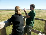 |
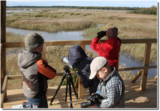
The viewing tower is in a seaside meadow near Mērsrags. It is an unusual type of biotope in Latvia and is located to the North of the Mērsrags port. The tower offers a good view of reed-filled meadows, areas where wild cattle have grazed, and an amazing wealth of different kinds of plants. |
|
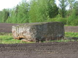 |
Rīgas - Daugavpils šosejas (A 6) 157. kilometrā skats jāpavērš Daugavas (rietumu) virzienā, kur cauri koku alejai klajā laukā 50 m attālumā no ceļa iegūlis Vaiķu akmens (7 m garš, 4,7 m plats un 1,7 m augsts). Akmens, kura tilpumu vērtē ~ 45 m³, pēc formas atgādina plakanu galdu. Nostāsti vēsta, ka to šeit atnesis velns. Kā jau šādiem akmeņiem „pienākas”, stāsta, ka te pusdienojis gan Krievijas cars Pēteris I, gan pats Napoleons. |
|
 |
It is rare type of lake in Latvia and there are only of few this type of lakes in Kurzeme region. The lake is characterized by high water limpidness (very attractive for tourists) and very rare plant species for Latvia. Nature park includes the lake, costal area and forest on the East from the lake, few smaller lakes and Sarlote Pond. There are several tourist accommodations located around the lake.
|
|
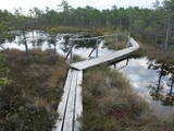 |
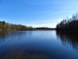
The Teiči Nature Reserve was established in 1982 and is one of the largest areas of moss swamps in the Baltic region. It consists of the Teiči and the Pelečāre swamps, with a variety of plants and animals, as well as adjacent territories which are under protection. The Teiči swamp is the largest nesting ground for a number of bird species, including the common crane, the whimbrel, the golden plover and the wood sandpiper. During migratory seasons, thousands of geese of various kinds are found in the area. The reserve can be toured only in the company of a guide from reserve headquarters, and one must apply in advance for such a tour. Visitors will see the pathway of footbridges on Lake Silda, as well as Siksala island, which offers a magnificent view of Latvian swampland from a viewing tower. |
|


