
| No | Name | Description |
|---|---|---|
 |
Burtnieku muižas parks, kas atradās kungu ēkas priekšā, ir valsts nozīmes dabas aizsardzības objekts, tika izveidots ap 19.gs. 60. gadiem 10 ha platībā. Iespēja doties ekskursijā pa Burtnieku muižas parku mazākā vai lielākā grupā. Ekskursijas laikā gida pavadībā iespējams iepazīt teikām un nostāstiem bagāto parku, apskatīt teiksmaino Burtnieku ezeru, kā arī baudīt nesteidzīgu pastaigu svaigā gaisā. Papildus tiek piedāvāta iespēja iegādāties oriģinālus Burtnieku suvenīrus, kuros dažādi meistari ielikuši ne vien savu talantīgo roku darbu, bet arī Burtnieku stāstu. Lai diena būtu piepildīta, gids ieteiks, ja nepieciešams, koordinēs un dosies līdzi apskatīt arī citus dabas un vēstures objektus tuvākajā apkārtnē. |
|
|
|
Meklējams pie Gulbjiem – Dvietes senlejas informācijas centra. No torņa labi pārskatāma ūdeņiem bagātos pavasaros pārplūstošā Dvietes paliene, dzīvei savvaļā pielāgoto mājlopu aploki un izlīkumotā Dvietes upīte. |
|
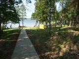 |
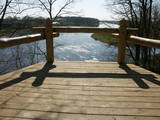
There is a small and relatively hard to reach area on the western shore of Lake Būšnieks which has been restricted to protect swamp habitats and several protected plants. Boat base is on the northern shore of the lake offers boat rental. From the plank-way good sites of eutrophic part of Lake Būšnieks can be seen. A well-appointed recreational facility (not included in the restricted area) is on the opposite shore of the lake. |
|
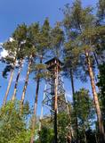 |
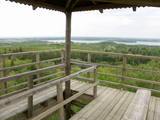
Uzcelts apkaimes augstākajā vietā – Ančupānu meža kalnā, kuru vietējie dēvē par „Bāku”. No 26 m augstā torņa redzama ļoti plaša panorāma ar Rēzeknes pilsētas namiem, baznīcu torņiem un apkaimes mežu masīviem, kas mijas ar lauksaimniecībā izmantojamām zemēm. Blakus tornim – atpūtas vieta. |
|
 |
The tower is on the western shore of the lake, next to the dam and the Zvidze canal. From here you will see the overgrowth north-western part of the lake, Akmeņsala Island, and a wide area of open water. The third is on the southern shore of the lake, by the dam and the Īdeņa canal. Here you will find typical views of wetlands – areas of reeds, shrubbery, wet meadows and the overgrown lake. |
|
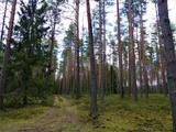 |
Ķekavas novada Daugmales pagastā atrodas pastaigām un dabas baudīšanai piemērots mežs, kurā baudīt dabas daudzveidību. |
|
 |
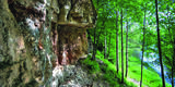
Atrodas mežā, netālu no Kaltenes. Labiekārtota (laipas, kāpnes, informācijas stendi) taka, kas iepazīstina ar Latvijai samērā neparastu dabas pieminekli (aizsargājams) – Kaltenes kalvām, kas ir lieli, līdztekus Rīgas jūras līča krasta līnijai orientēti laukakmeņu krāvumi. Uzskata, ka tos veidojuši Baltijas ledus ezera ūdeņi un ledi. Garums – ap 1,5 km. |
|
 |
1,2 km garā taka atrodas netālu no vietas, kur Gauju šķērso Vidzemes šoseja (A 2). Izejot taku, var iepazīt vienu no Latvijas augstākajiem dolomītiežu atsegumiem – Randātu klintis, kas paceļas 25 m virs Gaujas. Taka ir apļaveida un tās apskatei nepieciešamas ~ 45 minūtes. |
|
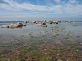 |
This is an important territory for the protection of reefs. It is opposite the Salacgrīva Administrative District and covers 3,577 hectares. The marine part of the “Rocky Shore of Vidzeme” nature reserve is a part of the territory.
|
|
 |
Īdeņa Castle mound is located near Lake Lubāns. A beautiful view
to the lake and to the marshy meadows. The place was inhabited from
the 11th century.
|
|
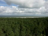 |
This lighthouse is in Ovīši, which is an ancient Livonian village. The 38-metre lighthouse on Cape Ovīši was built in 1814 and modernised in 1860, and it is the oldest functioning lighthouse in Latvia today. Visitors will get a great view of the shores of the Baltic Sea and the forests which cover them. The lighthouse also offers an exhibition devoted to the history of lighthouses in Latvia.
|
|
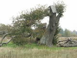 |
Before a great storm in 2005, this was one of the tallest and most noble lime trees in Latvia. Now only one branch is still alive.
|
|
 |
The Gauja National Park, established in 1973, was Latvia’s first national park, and it has a wealth of tradition in environmental protection and tourism. Indeed, the GNP is one of the most popular tourist destinations in Latvia. The main “artery” of the park is the ancient Gauja River valley, which was left behind when Ice Age glaciers receded. The valley is 95 kilometres long, with many tributaries that are also in deep ravines with massive sandstone cliffs from the Devonian period. The deepest part of the river valley is at Sigulda, where it is 85 metres deep. The territory has a great diversity of species – some 900 plant species in all. The Gauja is Latvia’s most popular river for water tourism, and many tourist accommodations are found along its shores. The Gauja National Park is one of the best-appointed protected territories in Latvia in terms of nature trails and tourism routes. Nature trails at Līgatne pass along paddocks of wild animals – the largest and most complete object of its kind in the Baltic States. The park also features cultural monuments of pan-Baltic importance – the Turaida Museum Reserve, the medieval old town of the city of Cēsis with its famous castle ruins and St John’s Church, the lake castle at Āraiši, etc. Visitors centres are found in Sigulda, along the Līgatne nature trails, and at the Zvārte rock. The administration of the GNP is building a new and modern visitors centre in Sigulda.
|
|
 |
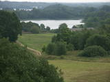
This is the highest point in the Latgale highlands (289 metres above sea level), opening up a narrow but lovely view of Lake Rāzna and the massive forests of the highlands. You really should visit this hill when the sun is setting beautifully!
|
|
 |
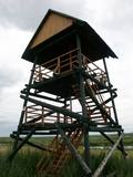
The forests of Zvārde are located on land which used to be a Soviet air base. The territory was unpopulated and was not accessible to civilians. The vast area includes various types of forest - boreal forest, bogs of black alder, etc. The fact that the military used to control the territory is one of the reasons why the forests of Zvārde are a location where many rare and protected birds live, reproduce and find food. Some of the elements of the old air base are still in place, including a unique surveillance platform. It is recommended that visitors to the area drive only along general use roads. |
|
 |
The Svene Nature Park is in the central part of the Augšzeme highlands, and Lake Svente is at its centre. This is one of the cleanest lakes in Latvia. There is also Egļukalns Hill, which offers one of the most beautiful views in all of Zemgale from its viewing tower. Visitors can gaze at the hillocks and lakes of the Svente area. Egļukalns Hill also has ski trails and a nature trail. |
|
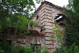 |
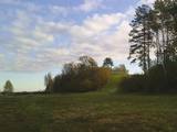
Atrodas Kraujā – Daugavas ielejas krasta malā un nogāzēs. Atrodama informācija, ka šajā vietā Livonijas kara laikā atradusies krievu karaspēka nometne. Muižas nosaukums cēlies no vācu Hof zum Berg – „Kalnu muiža”. Pēdējie muižas īpašnieki līdz 1. pasaules karam bija grāfu Šahno dzimtas pārstāvji. Viens no tiem – Marians Šahno 1910. gadā uzceļ muižas pili, kas bija būvēta eklektisma formās. Daļēji nojaukta tā pārdzīvo padomju laikus, līdz 2002. gadā nodeg. Līdz mūsdienām saglabājušās vien ēkas sienas, kuras slēpj biezs augājs. Var tikai iedomāties, kādi skati šeit kādreiz pavērušies uz Daugavas ieleju! Muižas parks ir vietējo iedzīvotāju pastaigu vieta. |
|
 |
Latvia’s newest national park (2007) is in the “land of the blue lakes” – the region of Latgale. One of the goals of establishing a national park was to preserve the natural treasures of the region. Lake Rāzna, which is the second largest in Latvia, is there, as is Lake Ežezers, which has more island than any other lake in Latvia. There are other bodies of water, as well as typical landscapes of hillocks and a unique cultural environment. One of the most popular destinations in the park is Mākoņkalns Hill, which offers a lovely view of Lake Rāzna. Administrators of the newly established park are working on the tourist infrastructure – trails, routes, etc. Perhaps visitors would be advised to postpone their trip to the Rāzna National Park for awhile. |
|
|
|
Andrupenes dabas takā var iepazīt sūnas, pārliecināties par sfagnu lielo ūdens uzsūkšanas spēju, gar laipas malām ieraudzīt apaļlapu raseni un purva dzērveni, apskatīt spilves, vaivariņus un purva vārnkāju, kā arī purva pasauli. Takas garums ~ 750m.
|
|
 |
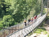
The Mežotne castle hill is on the left bank of the Lielupe River and opposite the Mežotne Castle. This was one of the largest Semigalian fortified castle hills during the 9th to the 13th century, and an ancient town alongside the hill covered 13 ha of land. The castle hill has been improved. A pontoon bridge across the Lielupe allows hikers and bikers to reach the castle (between May and October). Vīna Hill is approximately 500 m to the South of the castle hill, and a wooden pathway leads to it. |
|


