
| No | Name | Description |
|---|---|---|
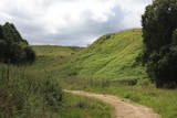 |
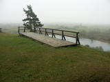
Found on the right bank of the Daugava, approximately half a kilometre upriver from the Skrīveri Agricultural Institute, the hill is in a place where the bank of the Daugava River Valley is split by the deep Ašķere stream valley. The castle hill was occupied beginning in the first millennium BC, with antiquities from the Lettigalian and Livonian tribes found there. During the 13th century, a brick castle was built on the hill, but it was sacked during the 17th century. Nothing remains of the castle. The castle hill is also known as Raven Hills, and it offers one of the most beautiful views of the central part of the Daugava. In the direction of Rīga, there is a field with a white cross that represents an ancient church. There is a hiking trail along the Ašķere stream. The area is well improved with four trails. The longest is the Daugava trail (10 km). |
|
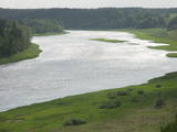 |
The Dinaburga trail first goes downhill, and then it quickly goes uphill to the steep shores of the Daugava river. Among a set of gullies, there is the Naujene (Vecpils) castle hill – some 25m high and the “cradle” of the city of Daugavpils. The ruins of the castle are still visible, and a unique open-air model of the old Dinaburga castle has been prepared. There is a lovely view of the Daugava river valley, and the visitor can expect to spend 20 minutes to an hour here. Objects are located in a protected area of Augšzeme landscapes and in the Curves of Daugava nature park.
|
|
 |
Covered with rocks and with small capes and inlets, this is the eastern shore of the Bay of Rīga and the only place in Latvia where sandstone outcrops are found. These are the result of the abrasive effects of waves between Tūja and Vitrupe. Among the most distinguished of these outcrops are the Veczemi cliffs, which are less than half a kilometre long and up to four metres high. The area has been improved for tourists. It has to be said that this part of the shoreline changes very often, particularly after large storms.
|
|
 |
The loveliest views of the local cultural and historical treasures (the Āraiši lake castle, the Lutheran church, the parsonage, Medieval castle ruins – all of these cultural monuments). The hillocks of the area which offers this view can be found in the immediate proximity of the Āraiši windmill and the Drabeši-Āraiši road.
|
|
 |
Takas sākums atrodas Vidagā, vietā, kur uz Vizlas celts vēsturiskais akmens arkas tilts. 1,2 km garā taka bez marķējuma ved gar pašu upes krastu līdz pat ietekai Gaujā. Redzami skaisti dolomīta atsegumi, nelieli krāčveidīgi ūdenskritumi un iespaidīgais Žākļu dižakmens. |
|
 |
Ap 1,6 km garā un labiekārtotā Adamovas dabas taka iepazīstina ar Adamovas krauju un tās apkaimē esošajām dabas vērtībām. Takas sākums meklējams pie autostāvlaukuma, no kura paveras plašs skats uz Krāslavu un Daugavas senieleju. Adamovas krauja (aizsargājams ģeoloģisks piemineklis) ir viena no garākajām (ap 1,7 km) un augstākajām (25 - 35 m) Daugavas kraujām. Tā veidojusies sānu erozijas rezultātā, Daugavas ūdeņiem noskalojot Daugavas pamatkrastu Adamovas loka ziemeļdaļā. |
|
 |
This tower is on the shores of the ancient Litorine Sea, with a lovely view of the unique seashore here – complete with small bays and capes. It is part of the Kaltene nature trail, which is around one kilometre long. The location is of particular interest during spring or autumn migration of birds. Two other bird-watching platforms are nearby.
|
|
 |
This territory is around 9 square kilometres in size and is found to the North of the village of Kūdra, where the so-called old peat quarries are found. Peat was extracted here during the first period of Latvian independence. Today the territory is overgrown, preserving the old and flooded quarries which offer a very unusual landscape. The best way to examine them is on foot or bike, taking the road from the Kūdra railroad station which leads to Lake Sloka. |
|
 |
The Dviete ancient river valley is a unique territory of environmental, cultural and historical importance between Kaldabruņas, Bebrene and Dviete. The small Dviete River flows through the ancient river valley, through Lake Skuķi and Lake Dviete, and through the wetland meadows that are alongside the valley. During flooding season, these wetlands store up water from the Daugava River, rapidly absorbing masses of floodwater and then slowly returning the water to the river. The views during wet springs are incomparable to anything else that can be seen in Latvia. The specifics of the shifting water level in the ancient river valley are the reason why this is an important place for plants and birds during migration and nesting season. The Dviete Wetlands Nature Park has been set up to protect the territory. It is interesting that higher areas which do not disappear underwater during the floods are known as islands. Archaeologists who have studied the Dviete ancient river valley have found 15 possible settlements of the ancients (from the Stone Age, Bronze Age and Iron Age). They found a wealth of ancient objects of various kinds. There is reason to believe that this is one of the oldest and most important settlements in what is now southern Latvia. |
|
 |
This is an uncommon landscape for the Kurzeme region with a protected biotope – open inland dunes with meadows of silver grass and forests of deciduous trees, including the common hornbeam. Tourists can visit the Muiža (Lejas) sacred stream on the right bank of the Sventāja valley, above which they will find Latvia’s most noble bird-cherry trees. A nice reed pergola has been installed above the stream. Wide are of Sventāja River valley can be overseen from the road before the stream. |
|
 |
In Dagda, on the side of Daugavpils Street, there is a forested hillock that is the Lubāne castle hill. On the upper part of its southern side, there’s a viewing area which offers a view of the small Lake Lubenenis, the eastern part of Dagda, and the white tower of the local Catholic church. Legend has it that treasure is buried here.
|
|
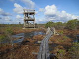 |
Atrodas 3,7 km garās laipu takas vidusdaļā. No torņa paveras viena no Latvijas izcilākajām augstā purva ezeriņu un lāmu kompleksa ainava. Tornis ir populāra saullēktu un ziemeļblāzmas fotografēšanas vieta. |
|
 |
Iespaidīgs pilskalns ar izveidotu apskates taku. Blakus ūdenstūristu apmetne „Kvēpene”.
|
|
|
|
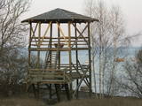
The viewing tower is on the western part of the Blue Hills of Ogre, not far from the Dubkalni quarry. Paths lead to the tower, as does a wooden staircase. The viewing platform offers a very broad view of the Ķegums hydroelectric power plant reservoir and the towers of
|
|
|
|
Viena no augstākajām Latvijas celtnēm ar vienu no augstākajiem skatu laukumiem (65 m). Paveras izcila Vecrīgas un Rīgas ainava, kā arī Daugavas (līdz Rīgas HES dambim) un Pārdaugavas skati. Labi redzami blakus esošie Rīgas centrāltirgus paviljoni. |
|
 |
This territory was established to protect the rare tree specie in Latvia - common hornbeam, which covers approximately 4% of the territory, but the most visually interesting part of the area is the Tīrspurvs swamp, also known as the Dunika heath. This is where the visitor will find Latvia’s longest and most impressive swamp footpaths, which crosses the area from the North to the South. Visitors will be fascinated by the unique landscape of the central part of the swamp, where in some places there are not even small swamp pine trees. Various habitats will be found – small swamp lakes, mineral islands, marsh pools, etc., and that is to say nothing of all the birds in the area. |
|
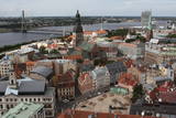 |
St Peter’s is one of the oldest historical monuments in the Baltic States, and it is also the best place from which to survey the historical centre of Rīga, which is part of the UNESCO list of world cultural heritage. You can see the central part of Old Rīga, City Hall Square, the Pārdaugava region on the opposite side of the river, and even – during clear weather – the Bay of Rīga. The tower of the church is 123 metres high, but the viewing location is at a height of 72 metres.
|
|
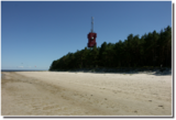 |
Cape Ragaciems – a promontory from
the western shore of the Bay of Rīga which
ends with a shallow and rocky submarine
shallows reaching several hundred metres
into the sea. The Ragaciems Lighthouse is
at the tip of the cape
|
|
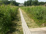 |
Near the Lielauce manor house start of a wooden pathway which crosses the transition-type swamp that is on the shore of Lake Lielauce to a boating facility near the open part of the lake. Boating and fishing are possible – here, too, the population of fish is regularly restored. The area is a part of the Vīķi swamp restricted zone. |
|
 |
This is the only viewing platform of its kind. It is north of Pāvilosta, between the sea and Latvia’s largest gray dune. The second level of the platform offers a good view of the habitats which surround the dune, as well as the seashore and the largest seashore rock on the shores of the Baltic Sea – the Pāvilosta sea rock. You can also see the northern part of Pāvilosta. When it is windy outside, you’ll see kiteboard riders showing their tricks.
|
|


