
| No | Name | Description |
|---|---|---|
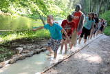 |
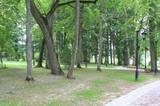
The first barefoot trail created in the Baltic States in the recreation complex "Valguma pasaule", which is located on the forested shores of Lake Valguma. When walking on the path, the feet "massage" sand, wood chips, clay, peat, gravel, cones and various other materials. |
|
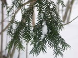 |
The forest covered area formed to protect tort protected plant species as yew-tree etc. Territory is not suitable for visitors as visitor without environmental knowledge will see “regular” forest.
|
|
 |
Vairākas salas Zvirgzdenes ezerā, uz kurām saglabājušies platlapju (ozolu, liepu) meži ar bagātīgu zemsedzes floru. Salas var redzēt no ceļiem, kas piekļaujas ezera ziemeļu un austrumu krastam. |
|
 |
There is a small and relatively hard to reach area on the western shore of Lake Būšnieks which has been restricted to protect swamp habitats and several protected plants. Boat base is on the northern shore of the lake offers boat rental. From the plank-way good sites of eutrophic part of Lake Būšnieks can be seen. A well-appointed recreational facility (not included in the restricted area) is on the opposite shore of the lake. |
|
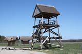 |
This barrow is on the western side of the Dunduri meadows and was built on the parking lot of the former collective farm. From the second level of the tower, you will have an excellent view of the meadows all the way to the Džukste River and the Kauguri canal. There are livestock accustomed to life in the wild, although they will sometimes be quite distant. This is a bird-watching location from the springtime until the second half of the summer. |
|
 |
The forests of Zvārde are located on land which used to be a Soviet air base. The territory was unpopulated and was not accessible to civilians. The vast area includes various types of forest - boreal forest, bogs of black alder, etc. The fact that the military used to control the territory is one of the reasons why the forests of Zvārde are a location where many rare and protected birds live, reproduce and find food. Some of the elements of the old air base are still in place, including a unique surveillance platform. It is recommended that visitors to the area drive only along general use roads. |
|
 |
Volzbahs ir stāva nogāze ar elpu aizraujošu skatu pāri gravai. Ziemā šeit pieejams vairāk nekā 100 m garš nobrauciens ar slēpēm, sniega dēli vai ragaviņām. Citos gadalaikos Volzbaha kalns ir lieliska atpūtas vieta- šeit ir labiekārtota vieta piknikam, pastaigām, foto sesijām. Rudenī Volzbaha kalns ir viena no labākajām vietām Vaiņodes novadā, kur vērot krāšņos rudens skatus. Volzbahs atrodas 2 km no Vaiņodes centra ZR virzienā. Kalnam ērti var piebraukt klāt ar automašīnām. Adrese: Vaiņodes pagasts, Dienvidkurzemes novads, LV-3435 Facebook: facebook.com/biedribavolzbahs Twitter: Volzbahs |
|
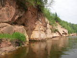 |
Eine der malerischen Sandsteinaufschüssen in Lettland. Die Länge beträgt ung. 500 m, die Höhe – 43 m. Gegenüber befindet sich die Ķūķu-Schnelle. |
|
 |
This is a large, outstanding and expressive tree, Latvia’s thickest Norway Maple (Accer platanoides).
|
|
 |
The Ungurmuiža park is well known for its outstanding and huge oak trees. Some of them are rotting or dead, and they are home to a great many species, including many that are found nowhere else in Europe. A pathway leads through these noble trees – 1.3km in length, with visitors spending as much as an hour there. The park also contains the only wooden castle from the early 18th century that has been preserved to the present day. There are other cultural and historical treasures, as well.
|
|
|
|
Atrodas Skuķu ezera ziemeļaustrumu krastā. No torņa labi saskatāms aizaugušais Skuķu ezers ar nelielām ūdens lāmām un ūdeņiem bagātos pavasaros pārplūstošā Dvietes paliene. Laba putnu vērošanas vieta. |
|
 |
Mud ponds for regeneration are used by
the spa and the rehabilitation centre. The mud
is purified from biological additives over the
course of a longer period of time, after which it
can once again be used for the famous
treatments offered at Ķemeri.
|
|
 |
Daugavas aizsargdambju būvniecību Jēkabpilī uzsāka pēc 1981. gada lielajiem paliem, kad ūdens līmenis pārsniedza kritisko - 6,3 m atzīmi un pakāpās līdz rādījumam „8,7 metri”. Šo plūdu laikā puse pilsētas klāja Daugavas ūdeņi. 2011. gada vasarā notika plašāki dambja atjaunošanas un labiekārtošanas darbi. Pie tā uzstādīja laternas, soliņus, izveidoja pastaigu promenādi un piemiņas zīmi Daugavas kreisajā krastā, kas parāda maksimālo plūdu līmeni. Uz aizsargdambja Daugavas labajā krastā ir izvietoti informatīvie stendi, kur var uzzināt daudz interesantus faktus par pilsētas vēsturi. Dambji ir piemērota vieta, kur fotografēt vai gleznot pilsētas ainavas. |
|
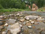 |
The Amata is one of Latvia's swiftest river, and water tourists congregate there each spring to engage in extreme activities. From the Rīga-Veclaicene highway, the Amata flows into a deep valley, with an average drop of more than 3 m/km or, downriver, as much as 8-10 m/km. Water tourists usually use the segment of the river between Melturi and the Zvārte cliff or the Veclauči bridge that spans the Līgatne-Kārļi road. Please remember that the Amata is not a friendly river for beginners. After lengthy rainfall, the river can be navigable during other times of the year, as well. The surrounding valley is attractive because of impressive sandstone and dolomite cliffs, among which the best known are the Vizuļi cliff (which can be the site of beautiful frozen waterfalls in winter), the Ainavu cliff, the Ķaubju cliff, the Dzilna cliff, the Zvārte cliff, and the Lustūzis cliff. Between Melturi and Veclauči, there is the Amata geological trail, which is marked with orange paint on tree trunks. There are three segments to the trail – from Melturi to the Kārļi fish farm, from the fish farm to the Zvārte cliff (both segments can be extreme!), and from the Zvārte cliff to the Veclauči bridge. You can hike the trail at any time except when there is deep snow. The most impressive views will be found when the trees are bare. If you boat down the river, you will not have time to look at or photograph the cliffs, because all of your attention will be focused on the river itself and the obstacles therein. |
|
 |
This is a natural monument of protected dendrological plants. The park is in the Upmala Parish, covers 2.7 ha, has been protected since 2001 and is managed by the Vārkava Administrative District Council. Judging from the oldest oak trees (approximately 200 years old), the park was established in the early 19th century, with other plants from the latter part of the century. Local species of trees, including maples, elms, fir trees, aspens, oak trees, willow trees, linden trees and hazelnut trees grow in the park, as do more than 10 exotic types of trees and bushes, including various types of maple, aspen, willow, lilac and linden trees. |
|
|
|
Atrodas Sedas purvā (Sedas dabas takas malā) ar plašu skatu uz izstrādātajām kūdras platībām. Sedas taku ieteicams izstaigāt vietējā gida pavadībā T: + 371 2636162. |
|
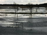 |
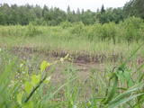
This is an open territory which is 3.5 km long and 2 km wide. It is located on the left bank of the Lielupe River between the village of Pavasari and the Odiņi homestead. The polder was established during the Soviet era to obtain farmland, and back then it was used very intensively. Today, it is slowly becoming overgrown, and despite this, this is one of the most important locations in Europe for corn-crakes. A gravel road crosses the polder from the North to the South, and this is an excellent place to hear the songs of the corn-crake. |
|
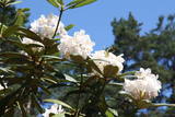 |
72 types of wild rhododendrons with 193 different species
This is the only specialised rhododendron nursery in the Baltic States. Specialists there work on different kinds of rhododendrons, seeking to produce decorative and winter-resistant types of the flower. The nursery also sells plants. In the facility’s pine forest, which covers 11.8 hectares, you can see a large collection of rhododendrons from all over the world.
There are 64 winter-resistant types of rhododendrons at “Babīte,” including “Alma Mater,” “Academia Scientiarum,” “Emeritus,” “Eduards Smiļģis,” “Dita Krenberga,” and others (these were developed by Rihards Kondratovičs). All of these are appropriate for Northern Europe.
|
|
|
|
10 km garais pārgājienu maršruts iepazīstina ar vienu no vēl retajiem, cilvēka mazāk ietekmētajiem Daugavas senlejas posmiem. Tā sākums – Aizkraukle, finišs – Skrīveri. Gar upes krastu izvietotas atpūtas vietas. Maršrutu var braukt arī ar velosipēdu. |
|
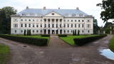 |
Work on the park began in end of 18th century, when it was a landscape park with trails for strolling and a system of pathways, benches and bridges. The 196-ha park is one of the largest estate parks in Latvia, and in dendrological terms it is one of the richest ones, with more than 200 varieties of trees and bushes, including 127 foreign ones. The park encircles the village of Kazdanga, including the Kazdanga Castle and the territory to its north, where you will find the burying grounds of the Manteuffel family. These were established at the very beginning of the 20th century, but the work was interrupted by World War I. The park features leisure areas and decorative elements. The castle was built around 1800 by the European-level architect Johann Gregor Berlitz after a design by architect Giacomo Quarenghi. The ensemble included a Cavalier House, a granary, a residential home, a stable, a bridge across the valley and other structures. An agricultural school was opened in the castle in 1924. Today it is the Kazdanga Museum, with the local Tourism Information Centre.. |
|


