
| Нo | Название | Описание |
|---|---|---|
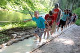 |
The first barefoot trail created in the Baltic States in the recreation complex "Valguma pasaule", which is located on the forested shores of Lake Valguma. When walking on the path, the feet "massage" sand, wood chips, clay, peat, gravel, cones and various other materials. |
|
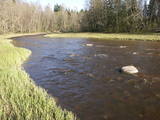 |
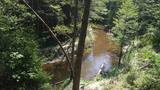
The nature park in the Ogre River valley is found along the middle section of the river. It has been established so as to protect the unregulated river valley and its surrounding territory, as well as biological diversity and habitats. For instance, this is an area in which rare park-type meadows can be found in Latvia. The Ogre is one of Latvia’s most popular rivers for water tourism in the spring, particularly downriver from the town of Ērgļi, where the technically complicated Braži rapids are found. |
|
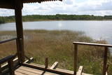 |
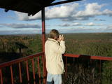
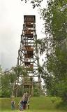
This is on the north-western shore of Lake Lielezers of Limbaži, at the start of the Lielezers nature trail. The tower opens up a view of the lake and its lovely shores. It is worth walking the trail, which is several kilometres long, because it is an interesting one. This is part of the ZBR. |
|
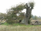 |
Before a great storm in 2005, this was one of the tallest and most noble lime trees in Latvia. Now only one branch is still alive.
|
|
 |
Very wide territory for a nature restricted area where extensive forests and several bogs can be found. The territory is important living space for many bird species. Vasenieku bog path with observation tower is the most attractive sites of the restricted area and offers unique landscape of the bog for its visitors. Waterproof shoes are recommended for visitors as the first 500 m of the path is molded turf rampart. Information stands are significant source of information along the path. It is suggested to visit also Stikli (Glass) village where glass factory used to be. Chandelier of Stende church has been made in this factory (by memory of Inese Roze).
|
|
 |
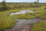
This restricted area was established to protect a high-type swamp, a swampy forest and a series of rare birds. The Niedrāji-Pilka swamp can be crossed with dry feet while enjoying almost virginal nature. This is possible on the narrow-gauge railroad embankment which runs through the swamp for three to four kilometres from the North-east to the South-west, or on the well-appointed circular wood pathway which is on the eastern size of the embankment.
|
|
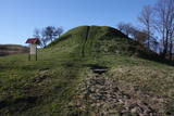 |
Arī Senču pilskalns, Baznīckalns un Velna gulta. Pirmo reizi minēts 1230. gadā kā viens no senās kuršu zemes Vanemas centriem. Ar šo objektu var sākt Abavas senlejas skaistāko skatu apzināšanu. Līdz pilskalna plakumam ved kāpnes, un no tā redzami senlejas vārti un upes ielejas kreisā krasta nogāze, kuras piekājē izvietojusies Jaunkandava.
|
|
 |
There is picnic area and information stand at the end of the forest path leading from Muiznieki to Klanu Bog. Klanu Lake was formed in the place of Littorina marine lagoon. Nature restricted area was established to protect biotopes in the area of Klanu, Dziru and Stavu Lakes. There is wide information about the area available on the information stand.
|
|
 |
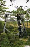
The viewing tower is in the southern part of the reserve, along the Ļaudona-Mārciena road and on the Madona-Trepe embankment. Here you can view a very wide territory all the way to the Vidzeme highlands, including Gaiziņkalns Hill if the weather is clear. At the foot of the tower you will see the lakes known as Small and Great Lake Plencis. |
|
 |
Dabas parks, kura lielāko daļu aizņem neprastās formas un līčiem bagātais Cārmaņa (arī Cārmins) ezers. Ezera ūdens ir ļoti tīrs, tādēļ tajā sastopamas Latvijai retas augu sabiedrības. Tā kā parka teritorijā nav tūristiem veidota infrastruktūra, interesenti var baudīt skatus, kas paveras uz ezera un tā apkārtni no Aulejas – Grāveru ceļa.
|
|
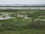 |
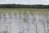
The Lake Lubāns depressions which are alongside the lake’s western and south-western parts feature little-changed forests and swamps, where many rare and protected birds nest. Many uncommon and protected habitats are in the region.
|
|
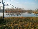 |
Cena's heath swamp's trail was made to introduce vistors to one of the most beautiful things in nature - a moss swamp. The pathway goes not only around beautiful swamp lakes but also meets the degraded part of the swamp. At the beggining and the end is a watch tower. |
|
 |
Тропа природы "Изгибы реки Риваc" начинается возле Улмалес-Лабрага лютеранской церкви и ведёт 3 километра вниз и вверх по обрывистым берегам реки Рива. Река здесь течёт по глубокому живописному оврагу глубина которого достигает 12 метров. Вы увидете бесчисленные речные повороты и крутые прибрежные скалы. Тропа частично доступна с ассистентом, тропа отмечена зеленой краской. |
|
 |
Охраняемая морская территория Нида – Перконе является одной из биологически многообразных и важных с точки зрения охраны природы морских территорий на побережье открытой части Балтийского моря – здесь находятся выдающиеся территории рифов. В период миграции территорию пересекает большинство мигрирующих пород птиц, встречающихся в Латвии. Расположенная напротив Руцавского и Ницского края территория площадью 36 703 га особенно важна для защиты большого крохаля и малой чайки. Территория частично перекрывается морской частью природного парка «Папе» и включает морскую часть территории природного парка «Бернаты».
|
|
 |
Lielais Liepu kalns ir Latgales augstienes Rāznavas pauguraines augstākā un Latvijā trešā augstākā virsotne (289,3 m v.j.l.). Lielpaugura relatīvais augstums ir 86 m! Skatu torņa platforma ir šobrīd augstākais Latvijas punkts (323 m.v.j.l.), kas sasniedzams ar paša kājām! Liepu kalna apkārtne ir labiekārtota. |
|
 |
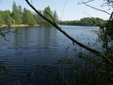
It is rare type of lake in Latvia and there are only of few this type of lakes in Kurzeme region. The lake is characterized by high water limpidness (very attractive for tourists) and very rare plant species for Latvia. Nature park includes the lake, costal area and forest on the East from the lake, few smaller lakes and Sarlote Pond. There are several tourist accommodations located around the lake.
|
|
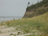 |
The Ziemupe nature restricted territory is on the shore of the Baltic Sea, and it protects a wide variety of coastline biotopes. The distinguished grey dunes are found here, as are various kinds of forest biotopes, some of them quite rare in Latvia. There are many protected plants and animals in the area, too. The Akmensrags lighthouse and several tourist accommodations, like camping Laikas who "Sējējs" award, are in the territory. On the sea shore not far from center of Ziemupe there is well-appointed parking area with information stands. |
|
 |
This is Latvia’s largest lake island and is found in the middle of Lake Usma. The island is restricted to protect old stands of pine, as well as various plants and birds. |
|
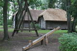 |
Доле является самым большим островом на Даугаве. С северо-востока его омывают быстрые воды Даугавы, а с юго-запада – спокойные и понемногу зарастающие воды бокового русла Даугавы. Острову присвоен статус природного парка (Особо охраняемая природная территория). Парк основан в 1987-м году с целью сохранения оставшегося после постройки Рижской ГЭС ландшафта острова и культурно-исторических ценностей, а также редких и охраняемых видов растений и животных. Еще одна цель образования парка – способствование просвещению и отдыху общества. Одним из известнейших объектов осмотра острова Доле является музей Даугавы, размещенный в жилом здании поместья Доле. В коллекции музея находятся ~ 13 000 различных экспонатов – свидетелей истории острова Доле и берегов Даугавы – одежда балтов и ливов, орудия труда, предметы быта. Экспозиция знакомит с историей Даугавы как значимого водного пути, а также с историей плотовщиков и транспортных средств этого пути. В парке поместья Доле размещена музейная экспозиция под открытым небом с реконструкцией заколов для миног и запруды для ловли лосося и коллекцией рыболовных снастей. Возле музея на обрывистом берегу бокового русла Даугавы находится доломитовое обнажение. На юго-востоке острова на берегу Даугавы возле хутора Бечи можно осмотреть руины замка Вецдоле. |
|
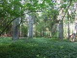 |
The Ukri forest on the border of the Dobele district is what is known as a vast forest. It has oak trees (including many huge ones), linden trees, oak trees (large stands of oak are uncommon in Latvia), and other deciduous trees. A small area of the forest can be toured in the company of a guide to look at the animals of the area and their importance in the flow of nature. The restricted area protects forest habitats, plants and animals, including many that are typical of the southern areas of Latvia. |
|


