
| Нo | Название | Описание |
|---|---|---|
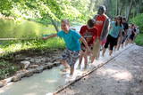 |
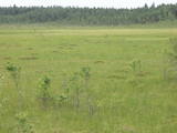
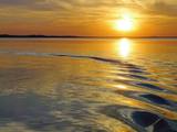
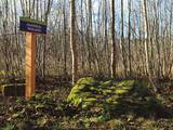
The first barefoot trail created in the Baltic States in the recreation complex "Valguma pasaule", which is located on the forested shores of Lake Valguma. When walking on the path, the feet "massage" sand, wood chips, clay, peat, gravel, cones and various other materials. |
|
 |
Established: 1959
60 coniferous and 350 deciduous trees
Brief description: Between the Tukums-Kolka road, the Lāčupīte stream and the sea, Igors Mednis has planted a series of foreign trees and shrubs. He has conducted experiments to see how different foreign plants adapt to different conditions. The best time to visit is in May and June, when the rhododendrons are in bloom.
|
|
 |
Ķurmrags is one of the most distinct capes along the Vidzeme shore of the
|
|
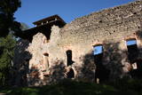 |
The ruins of the Rauna castle (which was built in 1262 and was a main residence of the Livonian archbishop) have a modern viewing tower which offers a view of the impressive castle walls, the place where the former Medieval city was located, and the centre of Rauna. The local government office has the keys to the tower.
|
|
 |
Dabas liegums veidots salīdzinoši neliela pārejas tipa purva aizsardzībai. Purvu lieliski var pārredzēt no nelielā skatu torņa.
|
|
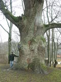 |
This tree is in the park of the Sēja Estate and is one of the four trees in Latvia that have a circumference of more than four metres.
|
|
 |
The tower offers a look at the historical centre of Limbaži , the castle ruins, and the landscape all the way to Lake Dūņezers. The Limbaži castle was part of Latvia’s earliest fortifications, and its unique gates survive to this very day. Keys to the tower can be found at the museum. This is part of the ZBR. |
|
 |
Atrodas ~ 0,4 km no Latvijas – Lietuvas robežas, Sventājas ielejas labā krasta nogāzē. Atrodama informācija, ka avotu tīrot, atklājusies 5 x 5 m ozolkoka „grīda”. Avots ir labiekārtots – virs tā slejas lapene ar niedru jumtu. Vēl pavisam nesen pie tā auga Latvijas dižākā ieva (nolūza), kuras vietā tagad kuplo biezs atvašu pulks. |
|
 |
Dabas parks, kura lielāko daļu aizņem neprastās formas un līčiem bagātais Cārmaņa (arī Cārmins) ezers. Ezera ūdens ir ļoti tīrs, tādēļ tajā sastopamas Latvijai retas augu sabiedrības. Tā kā parka teritorijā nav tūristiem veidota infrastruktūra, interesenti var baudīt skatus, kas paveras uz ezera un tā apkārtni no Aulejas – Grāveru ceļa.
|
|
 |
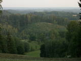
Zilais (Blue) Hill is the highest point in the Idumeja highlands – it is a very distinct hillock covered by forest, and from it there is a “narrow” landscape featuring the northern part of the highlands, as well as the Burtnieks flatlands. The restricted area is there to protect habitats such as gullies, hillsides and the boreal (northern) forest of the area. Zilais Hill is a popular tourist destination.
|
|
 |
Озеро Разна (57,8 кв.км), называемое народом морем Латгалии, по
вместимости воды самое большое в Латвии и находится на возвышенности Латгалии, на пригорках
Разнава. В живописной окрестности озера поднимаются самые высокие вершины Латгалии и латгальские
городища. На берегах озера находятся излюбленные места отдыха горожан. Чтобы уберечь и сохранить
уникальный комплекс природы, создан Национальный парк Разна, а территория включена в сеть Natura
2000 защищаемых территорий Европейского союза. В озере 10 островов, 2 залива. Уровень воды озера –
163,8 м над уровнем моря.
|
|
 |
This is a short stretch of the Daugava River valley between Lielvārde and Dzelme, with islands and shallows in the river, as well as with reeds and wet meadows alongside it. During migration season, many goose-type and plover-type birds rest and feed here. The location is also an important nesting area for several other kinds of birds.
|
|
 |
The Ukri forest on the border of the Dobele district is what is known as a vast forest. It has oak trees (including many huge ones), linden trees, oak trees (large stands of oak are uncommon in Latvia), and other deciduous trees. A small area of the forest can be toured in the company of a guide to look at the animals of the area and their importance in the flow of nature. The restricted area protects forest habitats, plants and animals, including many that are typical of the southern areas of Latvia. |
|
 |
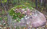
Большой чумной камень – с вырубленными письменами (немного еще про-
сматриваются), обращенными к будущим поколениям и повествующими о местном
пасторе того времени, который умер от чумы, и о создании пастората в Сикраге,
который в последствии был перенесен в Мазирбе. Чумной камень является и памят-
ником шести пасторам обширной окрестной общины. Все три камня повествуют о
Великой чуме 1710 года, а письмена на камнях вырублены во времена мазирбского
пастора Петерсона с 1711 по 1734 год.
|
|
 |
Atrodas Skuķu ezera dienvidrietumu krastā. Sasniedzams no Putnu salas, ejot cauri dzīvei savvaļā pielāgoto mājlopu aplokiem un taku. No torņa labi pārskatāma Dvietes paliene (ūdeņainos pavasaros pārplūst) un aizaugušais Skuķu ezers. Laba putnu vērošanas vieta. Putnu salas Atālu mājās – vietējais gids. |
|
 |
From the highest point in the Alūksne highlands, you will see an unusually beautiful view of the surrounding forested hillocks and the small areas of meadows and farmland. Sadly, there are no improvements to the location, which can be difficult to access. It is on private property.
|
|
 |
Камень Ажмугурас – коричнево-серая треугольная каменная
призма напоминает спину козла.
|
|
 |
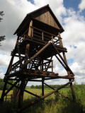
Viewing tower on pontoons, and there is a footpath to get to it. The tower offers a view of nearly all of Lake Sloka, all the way to Kauguri. Particularly visible is the northern part of the lake. There is also a sulphur spring. The site is good for bird-watching throughout the year, including the winter, because parts of the lake do not freeze over. |
|
 |
Яунсташульский камень чертова следа находится в деревне
Яунсташулю, в зарослях около заброшенных домов. Без знающего
человека это место трудно найти. Высота камня от земли 0,75 м,
окружность около земли 5,85 м. На его поверхности отпечатался человеческий след, длина которого
0,3 м, ширина 0,09 м, глубина 0,02. Был еще второй след, но, очевидно, откололся. В северный бок
камня как бы ударили три ступни.
|
|
 |
Another area where the manifestations water-soluble lime in the earth can be found. As the lime dissolves, there are empty areas underground which eventually collapse. To the East of Skaistkalne is a leisure area where dry and full holes of various sizes can be found.
|
|


