
Nature objects in Lithuania
What's special about the nature in Lithuania?
The Curonian spit - a sandy, desert-like stretch of land between the Baltic see and the Curonian Inlet, teh hilly landscapes of the Žemaitija region, the blue mirror labyrinths of the lakes in teh Aukštaitija region, the pine forests in teh Dzūkija region, the curves of the Nemuna river valley, and the many regional nature parks, created not only to protect the nature but also for people's recreation and interest - these are the nature values attracting guests of Lithuania.
Act responsibly - follow the Green advice!
| Overview | Details |
|---|---|
 |
Lithuania
Sarneles (Zviedru) pilskalns (Sarnelės (Svedų) piliakalnis)Viens no iespaidīgākajiem nacionālā parka pilskalniem, kura piekājē atradusies senpilsēta. Arheoloģisko izrakumu gaitā te atrastas kuršu senlietas. Tiesa, mežs un biezais augājs traucē uztvert šī nozīmīgā arheoloģijas pieminekļa patiesos apjomus un formu. Uz pilskalnu vasarās ved izpļauta taka. Ja esat Žemaišu Kalvarijas pusē un atliek brīvs brīdis, tad savā maršrutā var iekļaut arī šo apskates objektu.  317 317
Services
317km - Distance from countries capital city |
 |
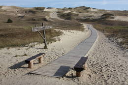
Lithuania
The Kursiu Dune (Kursių nerija)In terms of territory, it is the most impressive dune range in the Baltics. This is the only place in the Baltics, where one can enjoy open dune sands that are still active and, under the influence of wind, form the so-called eolian relief forms. There are trails, wooded trails and a paved bikeway for the conveniences of visitors. In order to protect the dune, The Dunes of Curonian spit National Park has been established . 340
Services
340km - Distance from countries capital city |
|
|
Lithuania
Burgberg SeredziausEine der malerischischen Burgberge am Fluss Nemunas mit schöner Sicht aufs Flusstal. In 13 – 14 Jh. befand sich hier eine militäre Festung, die nicht erhalten ist. 145
Services
145km - Distance from countries capital city |
 |
Lithuania
The Baltu Plant MuseumThis museum was established in 2014 in partnership with the Siauliai University botanical garden. The museum is 85 m long and 40 m wide on a territory that covers 0.34 ha. 
 5-9 5-9


Services
5-9 Active season monthsServices - other
Accepts individual travellers
Accepts tourist groups
This destination has specific opening hours which you must determine in advance
Must register in advance |
 |
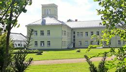
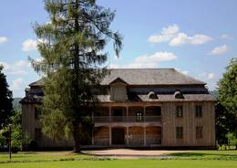
Lithuania
The Joniskelis Estate parkThe Jakiškiu Estate was first mentioned in documents in the late 16th century. The estate had elements of Classicism in terms of its architecture. Among the buildings, the only ones that have survived are the mansion, an ice cellar and a steam-driven windmill. The estate has not been restored, so it is still authentic. Its artistic soul is preserved by various objects that remain from the time when people lived at the estate and from the Soviet era. Alongside the estate are a few fragments of a park, which covers approximately 2 ha. There is an ancient alley of linden trees that are on both sides of the entrance road, as well as several other valuable types of trees and a small pond. 1-12
Services
1-12 Active season monthsServices - other
Accepts tourist groups
Accepts individual travellers
This destination has specific opening hours which you must determine in advance |
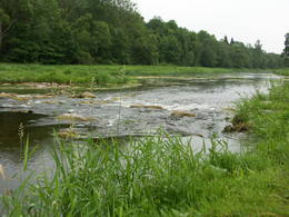 |
Lithuania
The Dubysa Regional ParkThis park was set up to protect the lovely ancient valley of the Dubysa River. This is one of the most popular rivers for water tourism in Lithuania, because it has a significant drop with rapids and beautiful shorelines.
ServicesServices - recreational
Boat tourA one-day boat trip from the Raseiniai-Baisogala road bridge to the Ariogala bridge. For more information: www.dubysa.info (very little information available in English). |
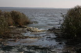 |
Lithuania
Kurisches HaffDas beinah 100 km langes und bis zu 36 km breites aus dem Süßwasser bestehende Haff, das im Norden mit der Ostsee verbunden ist. Das Haff trennt vom Merr die eindrucksvolle Kurische Nehrung. Ins Kurische Haff mündet der größte Fluss Litauens Nemunas ein. 310
Services
310km - Distance from countries capital city |
 |
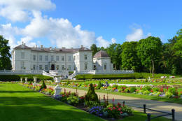
Lithuania
The Rietavas Estate ParkThe Rietavas Park was once the largest landscape park in Lithuania. It was established between 1848 and 1855 in a naturally cleaned forest and reconstructed in 1904 and 1905. This is a very nice park with local bushes and trees, as well as several foreign plants. Various alleys of trees and fragments of the hedges have been preserved along with the white gate, the red gate and a guard's hut. The park has a complex system of bodies of water, including a few ponds, a curvy river and an island that is surrounded by the old river. 1-12
Services
1-12 Active season monthsServices - other
Accepts individual travellers
Accepts tourist groups
This destination has specific opening hours which you must determine in advance |
 |
Lithuania
Negelsches Naturreservat (Naglių rezervatas)Die Dünen nördlich Pervalka über dem ehemaligen Dorf Negeln. Eine 9 km lange Strecke mit den wüstenartigen Landschaften. Stegpfade. 356
Services
356km - Distance from countries capital city |
 |
Lithuania
Cepkelu purvs (Cepkelių raistas)Lietuvas lielākais sūnu purvs, kura aizsardzības nolūkā ir izveidots Čepkeļu dabas rezervāts (Čepeklių gmatinis rezervatas). Tas izvietojies starp Dzūkijas nacionālā parka dienvidaustrumu daļu un Baltkrieviju. No Marcinkones pa smilšainu meža ceļu (~ 9 km turp - atpakaļ) ar kājām vai divriteni (arī nelielu tūrisma autobusu līdz 20 vietām) var nokļūt līdz purva malai, kur mežainās kāpās un purvā izveidota 1,5 km gara dabas taka un skatu tornis, no kura labi pārredzama purva rietumdaļa. Pirms došanās uz Čepkeļu purvu, ir jāreģistrējas Dzūkijas nacionālā parka apmeklētāju centrā (Šilagėlių gatve 11), kas meklējams aiz dzelzceļa pārbrauktuves. Te apskatāma neliela nacionālajam parkam un rezervātam veltīta ekspozīcija. 112
Services
112km - Distance from countries capital city |
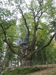 |
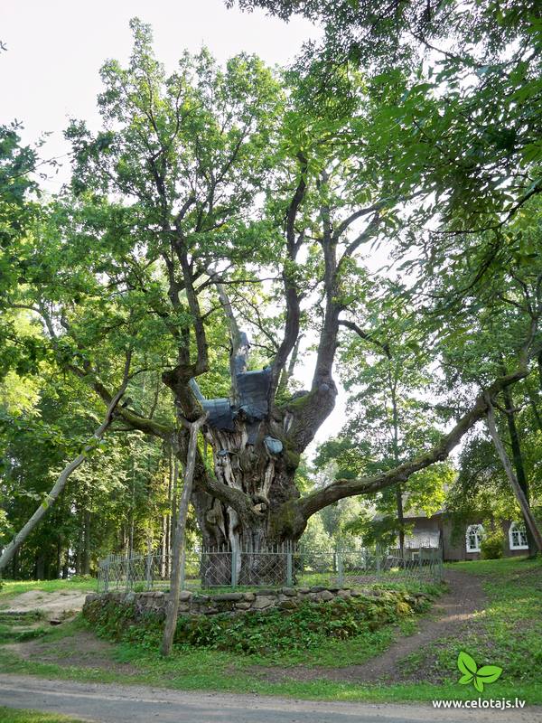
Lithuania
The Stelmuzės oak treeThis is the thickest English oak (Quercus robur) in Lithuania, with a circumference of 9.4 m (as opposed to the Kaive oak in Latvia, which has a circumference of 10.18 m).
|
 |
Lithuania
The Palanga Botanical GardenThe Palanga Botanical Garden surrounds the Palanga Amber Museum and is one of Lithuania's most beautiful and well-kept parks. It is in the area of the St Birute Forest, and it is familiarly known as the Birute Park. The park covers 101.3 ha of land, and offers a wide variety of landscapes, carefully organised trails, flowerbeds, two ponds and small architectural elements. 1-12
Services
1-12 Active season monthsServices - other
Accepts individual travellers
Accepts tourist groups
This destination has specific opening hours which you must determine in advance |
 |
Lithuania
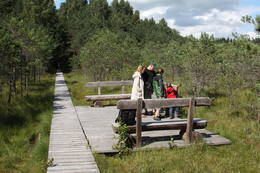
Varniku izzinas taka (Varnikų pazintis takas)Varniku mežā (Varnikų miškas) ir izveidota patiesi interesanta dabas izziņas taka, kas iet cauri dažādiem biotopiem – skujkoku un ozolu mežiem, purvainu mežu un sūnu purvu ar akačiem un nelieliem purva ezeriņiem, kur uzceltas divas skatu platformas. Mitrajās vietās un purvā ir izveidotas koka laipas. Šī ir populāra pastaigu vieta. Taka ir lokveida un marķēta. Tās apskatei būs nepieciešama ~ pusotra stunda. |
 |
Lithuania
The Kurtuvenai Estate ParkThis estate is surrounded by an ancient and geometric landscape. During the latter half of the 19th century, it had a landscape style with various elements of geometry. The park covers 4.2 ha and has ancient linden, maple, elm, oak and other decorative bushes, with more than 20 types of plants that have turned into wood. 1-12
Services
1-12 Active season monthsServices - other
Accepts tourist groups
Accepts individual travellers
This destination has specific opening hours which you must determine in advance |


