
Nature objects in Estonia

What's special about the nature in Estonia?
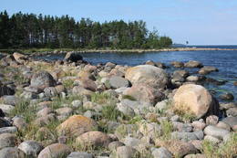
In Estonia, there stands the most impressive rock wall in the Baltics - the so called North Estonian "glint" (from Estonian language). Estonia has its own "Land of Inlets" - the Lahemaa region with its national park, the "Land of Islands" - the Saaremaa island and the Monzund archipelago. The Matsalu bay is one of the most significant rest stops for birds during their migration. In Estonia there is one of the most prominent impact craters in Europe, there are the greatest waterfalls and boulders in the Baltics, the Munamagi hill - the highest spot in the Baltics, the Lake Peipus - the 5th largest lake in Europe, - with long-standing fishing traditions, and the great variety of nature from West to East, from North to South.
Act responsibly - follow the Green advice!
| Overview | Details |
|---|---|
 |
Estonia
Moor TolkuseDurch das höchste Dünen-Massiv Estlands und den Moor führt der Lehr-Wanderweg. Blick vom Aussichtsturm bis auf die Insel Kihnu.  175 175
Services
175km - Distance from countries capital city |
 |
Estonia
Skatu platforma Puises ciemaPuises „centrā” uz vienstāvu koka mājiņas jumta izveidota skatu platforma. No tās paveras laba ainava uz ciemu, ostu un piekrastes kadiķu laukiem. 121
Services
121km - Distance from countries capital city |
 |
Estonia
Haeskas putnu verosanas tornis (Haeska linnutorn)Pamatīgs trīsstāvu koka tornis, no kura atklājas viens no labākajiem Matsalu līča un tā apkaimes palieņu pļavu skatiem, kuras apsaimnieko mājlopi, veidodami piemērotu vidi dažādām putnu un augu sugām. Laba migrējošo zosveidīgo putnu vērošanas vieta. Tā kā tornis ietilpst Tūlingu (Tuulingu) saimniecības teritorijā – spēkrats ir jāatstāj netālu esošajā autostāvlaukumā, bet suņi jāved piesieti kakla siksnā. |
 |
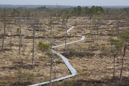
Estonia
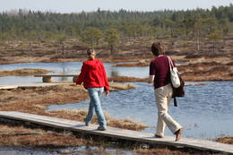
Hjupasares pargajienu taka (Hüpassaare matkarada)Iepazīstina ar Somā nacionālā parka lielākā purva – Kureso (Kuresoo) ziemeļaustrumu daļu, kur redzamas purva ezeriņu un lāmu ainavas. Takas sākumā atrodas igauņu komponista, ērģelnieka un folkloras vācēja Marta Sāra (Mart Saar) (1882. – 1963.) dzimtās mājas. To apkaimē pļavas apsaimnieko aitas. Lokveida takas garums ir 4,2 km. 169
Services
169km - Distance from countries capital city |
 |
Estonia
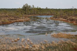
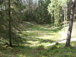
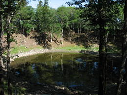
The Ilumetsa meteor cratersThere are three craters here, and the biggest one, known locally as Põrguhaud, or Grave of Hell, has a diameter of 80 m and a depth of up to 12 m. There are barriers around the crater that are several metres high. The other two craters are hard to spot. The craters around 6,000 years old. No scraps of the supposed meteorite have been found, however, and so the origins of the craters cannot be confirmed with certainty.
ServicesServices - recreational
Nature trailThe trail to the Põrguhaud crater is around 700 metres in length. For more information: http://www.ut.ee/BGGM/vaatamis/ilumetsa.html (only in Estonian). |
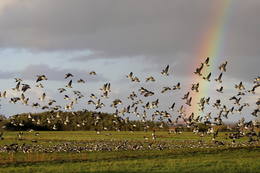 |
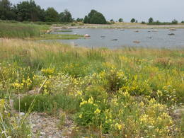
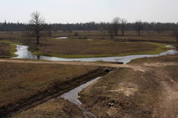
Estonia
The Matsalu National ParkThis is one of the most popular bird-watching locations in Estonia, and during spring and autumn migration there are a great many different kinds of birds resting and feeding in the meadows and shallow coastal waters of the Bay of Matsalu and the Kasari River.
Services
1-12 Active season monthsServices - recreational
Boat tourBoating on the Bay of Matsalu and the Kasari River can be organised.
Nature trailThe Kiideva-Puise hiking trial (5 km), the Penijõe trail (3 km), the Salevere information trail (1.5 km). 
Nature watchingBird-watching is possible throughout the park, especially on the shorelines, in wetland meadows and heaths. There are bird-watching towers or platforms at Puise, Kiideva, Haeska, Rannajõe, Kasari jõgi, Penijõe, Suitsu and Keemu. The visitor centre is in the village of Matsalu. For more information: www.matsalu.ee (available in English). |
 |
Estonia
Kaali meteorite cratersThis is actually a group of nine craters, and some of them are as much as 100 m in diameter and 16 m in depth. This is the most visually expressive meteorite crater in the Baltic States and, indeed, in all of Europe. Remnants of the meteorite – some 2.5 kg in all – yielded iron and nickel. It is thought that this pan-Baltic natural catastrophe occurred 2,600 to 4,000 years ago. Kaali Visitor Centre comprises the meteoritics and limestone museum, a conference hall and a hotel.The museum exhibits genuine meteorite pieces amongst other items. The hotel has all modern conveniences, tasty food is provided at Kaali Tavern nearby. 204
1-12
Services
204km - Distance from countries capital city
1-12 Active season months |
 |
Estonia
Risas purva taka (Riisa rabarada)Izcila lokveida taka (4,5 km), kuras lielākā daļa (koka laipas) ved pa Rīsas purvu (Riisa raba). No takas un divstāvīgā koka skatu torņa ir vērojami purva ezeriņi, lāmas, un purvaini meži. Ja nacionālā parka apskati sāk no ziemeļu puses, tad šī taka ir labs ceļojuma iesākums! |
 |
Estonia
Moorpfad ViruEin 3,5 km langer Pfad quert den Viru Moos in Richtung Süd–Nord. Von einem Holzaussichtsturm eröffnet sich einen Blick auf eine typische Hochmoorlandschaft mit einigen Seen, Aushöhlungen und morastigen Stellen. 56
Services
56km - Distance from countries capital city |
 |
Estonia
Skats uz Vaikas salam (Vaika saared)No Vilsandi bākas un tai tuvākās apkaimes ir labi saskatāmas leģendārās Vaikas salas. Tām ir piešķirts rezervāta statuss, tādēļ salas var apskatīt tikai no attāluma. Mazākā no saliņām - Kullipank ir tikai pārdesmit metrus diametrā. Tā ir jūras ūdeņu izrobots zemas un asas dolomīta klints fragments, kas klāts ar oļiem, nelieliem laukakmeņiem un kādu atsevišķi stāvošu lakstaugu. Domājams, ka vētru laikā tā pazūd zem jūras ūdens. Savukārt, Alumine Vaigas – Apakšējā Vaikas sala ir lielākā no sešām salām. Šīs salas diametrs ir ~ 150 m un tā paceļas vismaz kādus divus metrus virs jūras līmeņa. Uz salas ir bagātīga veģetācija un pat kāds zems krūms salas centrā. Redzami arī metru augsti atsegumi. Uz salas vēl joprojām atrodas 20. gs. sākumā celto „putnu māju” paliekas, kas bija domātas ligzdojošo putnu piesaistīšanai. |
 |
Estonia
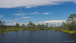
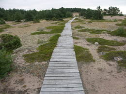
The Lahemaa National ParkThis is the first national park in Estonia and the Baltic States. Perfect for a day trip out from Tallinn for a hiking trip and nature watching. It was established in 1971 to protect the area that is along the Bay of Finland – the shoreline, forests, swamps, meadow biotopes, species, natural monuments, rocks, waterfalls, cliffs and cultural monuments such as ancient cemeteries, castle hills, baronial estates, fishing villages, etc. Services
50km - Distance from countries capital cityServices - recreational
Cross-country skiingFor cross-country skiers, the Käsmu peninsula is perfect during the season. 
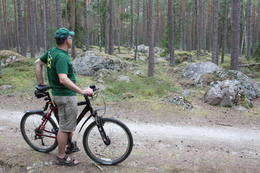
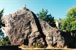
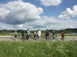
Bicycle trailFor bikers, there’s the Käsmu peninsula (~10 km), the route Loksa-Pärispea-Viinistu-Kasispea on the Pärispea peninsula (here you will find the highest rock in the Baltic States – the Jaani-Tooma rock (kivi, 7.8 metres high).
Nature trailYou can hike a wooden train over the Viru swamp (Viru raba, 3.5 km), another trail on the Käsmu peninsula (~15 km), and the Pikanõmme-Majakivi trail (4.5 km), along which you will find the third largest rock in the Baltic States – the so-called House Rock (Majakivi), which has a size of 584 m3. We also suggest the informational Altja trail (3 km).
Nature watchingThere are viewing towers in the Viru raba swamp and along the Piaknõmme-Majakivi trail. There is a visitor centre at Palmse. |
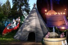 |
Estonia
Lahemaa Hiking CentreThe Centre promotes sustainable lifestyle and the great outdoors, there you can plant trees and make and install nest boxes. Canoeing, bog walks, bow and crossbow shooting ranges are available for the more adventurous. There is a log house for functions and accommodation and a sauna with a hot tub. 70
1-12
Services
70km - Distance from countries capital city
1-12 Active season months |
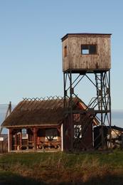 |
Estonia
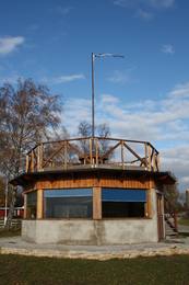
Kemu skatu tornis (Keemu vaatetorn)Meklējams Matsalu līča dienvidu krastā pie Kēmu ostas (Keemu sadam). Blakus sešus metrus augstajam metāla – koka tornim uzcelts neliels apmeklētāju centrs. Tāpat kā no Haeskas torņa, arī no šī paveras viena no izcilākajām Matsalu līča un tā piekrastes ainavām. Laba putnu vērošanas vieta migrāciju laikā. 129
Services
129km - Distance from countries capital city |
 |
Estonia
Rebases ainavu taka (Rebäse maastikurada)Ap 7 km garš lokveida pārgājienu maršruts (marķēts), kas ved pa dažādiem biotopiem – mežiem, mitrājiem un pļavām, mezdams līkumus pa stāvo pauguru nogāzēm. Takas malās ir izvietoti informācijas stendi un norādes. Rebases ainavu taka ir domāta tiem, kurus nebaida garāka iešana un orientēšanās pa ļoti dabisku un mazapdzīvotu apvidu. |
 |
Estonia
Mohni sala (Mohni saar)Igaunijas jūras ūdeņos ir saskaitīta 1521 sala! Salu sarakstā pēc platības (63 ha) ~ 2,5 km garā Mohni sala ieņem 38. vietu. Lai saudzētu salas trauslo veģetāciju (vietām nedaudz atgādina krūmainu tundru), tās vidusdaļā ir izveidotas koka laipas. Salas dienviddaļā atrodas sašaurinājums, kuru tāpat kā blakus esošo jūras krastu klāj viens no savdabīgākajiem Igaunijas akmeņu laukiem. Salas ziemeļos esošās Mohni bākas (Mohni tuletorn) celtniecība pabeigta 1871. g. un tās gaisma ir redzama 10 jūras jūdžu attālumā. Šī ir viena no skaistākajām Ziemeļigaunijas bākām! Līdz Mohni salai var nokļūt ar laivu (iepriekšēja pieteikšanās) no ~ 5 km attālās Vīnistu ostas (Viinistu sadam). Ar jūras laivu vai kajaku piemērotos apstākļos būs ~ 1h ilgs brauciens. Jārēķinās, ka uz salas nav pastāvīgo iedzīvotāju! Vīnistu ciemā apskatāms 2002. g. izveidotais Vīnistu mākslas muzejs (Viinistu kunstimuuseum). Apmeklētājus iespaidos ne tikai tā āriene, bet arī tapšanas vēsture. 76
Services
76km - Distance from countries capital city |
 |
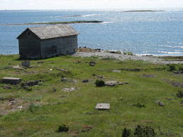
Estonia
NaisaarThis is a forested island in the Bay of Finland which is the 6th largest Estonian island and is found 14 km to the N of Tallinn. Two decades ago it was a closed zone, because the Soviet Union had a highly secretive manufacturing plant for maritime mines here.
ServicesServices - recreational
Bicycle traila route around the entire perimeter of the island (~20 km). A ferry boat will take you to the island from the Pirita port.
Nature trailThere is a hiking route along the southern part of Naisaar Island (13 km), as well as a military route (10 km), a central route (11 km)
Nature watching |
|
|
Estonia
Klostri (Kloostri) skatu tornisMetāla tornis Kazari upes kreisajā krastā, ~ 5 km attālumā no Matsalu līča. No torņa redzamās Kazari deltas palieņu pļavas atrodas tikai 0,3 – 1 m augstumā virs jūras līmeņa, tādēļ pavasara palos un stipru vētru (īpaši rietumvēju) laikā ūdens appludina milzīgu teritoriju. Uzskata, ka platības ziņā šīs ir vienas no lielākajām Eiropas palieņu pļavām, kas ir nozīmīga dažādu tārtiņveidīgo putnu sugu ligzdošanas, dzērvju un zosveidīgo putnu atpūtas un barošanās vieta. Ir pagājis laiks, kad zemnieki Matsalu pļavās ganīja govis un pļāva sienu, tādēļ šobrīd pļavu apsaimniekošanu veic nacionālā parka administrācija. |
 |
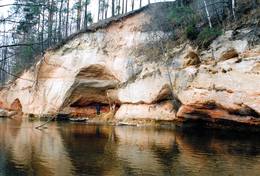
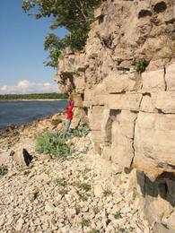
Estonia
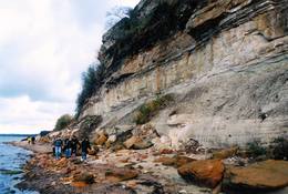
Turisalu cliffThis cliff is made of sandstone (its lower part) and limestone (the upper part). It is up to 30 m high, and it is part of the Northern Estonian set of cliffs along the shore of the Bay of Finland. This is a popular tourism destination and viewing location. Recommended Hike along the bottom of the cliff (a rocky beach) in one direction, and then along the top of the cliff to get back (~2 km). From the top of the cliff, you can see a broad segment of the shoreline territory, all the way to Tallinn.
|
 |
Estonia
Halbinsel KäsmuEine von Nadelbaumwäldern bedeckte Halbinsel. Malerisches Käsmu Steinfeld, Matsikivi Stein, Vana Jüri Stein u.a. Bei passenden Bedingungen kann man sich auf einer steinernen Landzunge bis zur 0,5 km entfernt liegenden Insel Saartneem schleppen. 81
Services
81km - Distance from countries capital city |
 |
Estonia
Kidevas (Kiideva) putnu verosanas platformasPirmā ir uzcelta uz vienstāvīgā apmeklētāju centra jumta. No tās paveras plašs skats uz Kīdevas ciemu, ostu un niedrēm apaugušo Matsalu līča ziemeļdaļu. Austrumos no šīs atrodas vēl viena - divstāvīga putnu vērošanas platforma. No Kīdevas līdz Puisei gar Matsalu līča var doties pārgājienā pa 5 km garo dabas taku. To izejot, novēroto putnu sugu klāsts noteikti būs lielāks! |
 |
Estonia
The Rock of Jana - TomaThe Rock of Jana - Toma is claiming itself to be the highest (almost 8 m) rock in The Baltic. It is located in Kasispea village. 72
Services
72km - Distance from countries capital city |
 |
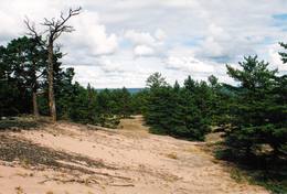
Estonia
The Otepää Nature ParkThis park is found in the Otepää highlands and offers an outstanding example of how the terrain of a protected natural territory can be used for recreation, sports and active leisure. The infrastructure of the park is perfect for such activities and is of a high level of quality.
ServicesServices - recreational
Cross-country skiingDuring the winter, you can ski the 63-km Tartu marathon trail, which crosses the park.
Bicycle trailBike around Lake Pühajärv from the centre of Otepää (~20 km), or ride from Otepää to Kääriku (11 km).
Nature trailHike around Lake Pühajärv (12 km), hike the Kekkose hiking route (14 km), or hike the Murrumetsa hiking trail (3.5 km). Bike around Lake Pühajärv from the centre of Otepää (~20 km), or ride from Otepää to Kääriku (11 km).
Nature watchingThere are viewing towers at Harimägi and in the hills of Kuutsemägi, near the Otepää ski jump, at Väike Munamägi, and near the Otepää castle hill. For more information: www.otepaaloodus.ee (available in English). |
 |
Estonia
Aegna IslandThis is an entirely forested island in the Bay of Finland, ~14 km from Tallinn. A network of small pathways covers the entire island. Recommended hike along the seashore of the island, which will offer dunes, as well as a coastline that is sandy in some parts, rocky in others, and covered with reeds in still others (~9 km). A ferry boat will take you to the island from the Pirita port.
|
 |
Estonia
Piirissaar islandThe island of 7.5 km2 in Lake Peipsi is largely inhabited by Russian-speaking Old Believers who have broadly retained their old traditions through time. Traditional trades are fishing and growing vegetables, mainly onion. 262
1-12
Services
262km - Distance from countries capital city
1-12 Active season months |
 |
Estonia
Ancient Võhandu River valleyThis is one of the most beautiful ancient river valleys in Estonia – 12 km long with nearly 40 revealed Devonian sandstone cliffs. Among these, the most important ones are Viira müür, Kalamatu müür, and Põdramüür.
|
 |
Estonia
Terama taka (Tõramaa matkarada)Divarpus kilometrus gara taka (vienā virzienā) aizved līdz Hallistes palieņu pļavām, kur Hallistes upes labajā krastā ir uzcelts divstāvīgs koka skatu tornis. No tā paveras visaptverošs skats uz atjaunotajām (izcirsti krūmi) Hallistes palieņu pļavām. Pavasara palu laikā no torņa redzamā apkārtne un tornis atrodas ūdenī. |
|
|
Estonia
Castle Hill OtepääVery expressive form of relief with wide look over the neighborhood. On its peak there's ruins of the castle of bishop Hermanis which was built in 1224. The world's oldest firearm was found here. 225
Services
225km - Distance from countries capital city |
 |
Estonia
Saleveres Salumegi kalns (Salevere Salumägi)Litorīnas jūras laikā (pirms ~ 6000 gadiem) Saleveres Salumegi kalns bija sala, bet mūsdienās tas kā izteikta kāple (īpaši - ziemeļu pusē) paceļas virs Piejūras līdzenuma. Salumegi ziemeļu pusē slejas 4 - 5 metrus augsts kaļķakmens atsegums – silūra perioda (> 400 mlj. gadu) koraļļu rifa paliekas, kuru noskalojuši Litorīnas jūras viļņi. Atseguma piekājē izplūst Acu avots, kam piedēvē dziednieciskas īpašības. Salumegi apskates nolūkos izveidota lokveida taka (1,5 km). No kalna augšas paveras labs skats uz Matsalu līci. Šeit atradies arī sens pilskalns. 132
Services
132km - Distance from countries capital city |
 |
Estonia
Eldas klints (Elda pank) un pussalaNacionālā parka dienvidrietumdaļā jūrā iestiepjas Eldas pussala – skaists un ļoti omaļš ar kadiķu mežu (alvāriem) noaudzis zemes pleķītis ar interesantu jūras krastu, kur atsedzas silūra perioda nogulumieži. No pussalas gala, kurā slejas vecs Padomju armijas robežsargu tornis (apmeklējumam bīstams!), paveras visaptverošs skats uz Vilsandi salu (atpazīstama pēc bākas), Lonalaidas salu (Loonalaid) – otru lielāko Vilsandi arhipelāgā, Salavu (Salava) un citām mazākām saliņām. Dabas mīļotāji var uzmeklēt Eldas klinti (Elda pank) – ~ 2 m augstu un 0,4 km garu atsegumu, kura piekājē var atrast interesantas ūdens izskalotas fosilijas. 261
Services
261km - Distance from countries capital city |
 |
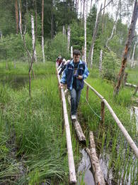
Estonia
Ignatsi pargajienu taka (Ignatsi matkarada)Taka iesākumā ved pa mežu ieskautu bijušo šaursliežu dzelzceļa līniju, pa kuru pagājušā gadsimta vidū izveda kokmateriālus. Tās tālākā daļa izmet nelielu loku pa Suistna purvu (Suistna raba), kur uzcelts skatu tornis ar izcilu sūnu purva ainavu ar nelieliem ezeriņiem. Takas garums vienā virzienā ir 4,5 km. |


