
Nature objects in Estonia

What's special about the nature in Estonia?
In Estonia, there stands the most impressive rock wall in the Baltics - the so called North Estonian "glint" (from Estonian language). Estonia has its own "Land of Inlets" - the Lahemaa region with its national park, the "Land of Islands" - the Saaremaa island and the Monzund archipelago. The Matsalu bay is one of the most significant rest stops for birds during their migration. In Estonia there is one of the most prominent impact craters in Europe, there are the greatest waterfalls and boulders in the Baltics, the Munamagi hill - the highest spot in the Baltics, the Lake Peipus - the 5th largest lake in Europe, - with long-standing fishing traditions, and the great variety of nature from West to East, from North to South.
Act responsibly - follow the Green advice!
| Overview | Details |
|---|---|
 |
Estonia
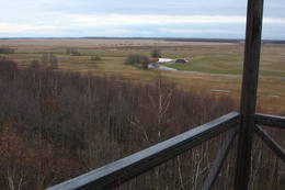
Torna kalns (Tornimägi)Karulas augstienes augstākais reljefa punkts (137 m.vjl.), kas virs tuvākās apkārtnes paceļas par ~ 60 m. Torņa kalnā ir uzbūvēts skatu tornis ar ļoti plašu apkārtskatu. Uz tā platformas ir novietoti panorāmas fotoattēli, kuros atzīmēti zīmīgākie plašākā apkaimē redzamie objekti – apdzīvotas vietas, pilskalni, baznīcu torņi u.c. Turpat izveidota atpūtas vieta un meklējams Rebases ainavu takas sākums.  260 260
Services
260km - Distance from countries capital city |
 |
Estonia
KassariThe Kassari Island is the fifth largest Estonian island, and it is found to the South of the Hiiumaa Island. There are two dams between the two islands, and a road for motor vehicles has been installed atop them.
Services
150km - Distance from countries capital cityServices - recreational
Bicycle trailBike the route Käina-Orjaku-Kassari-Esiküla-Käina (22 km). 
Nature trailThe Orjaku nature trail (up to 2 km); the Sääre tirp – a 3-km hike along a rocky path on the southern end of the Kassari Island; 
Nature watchingBirdwatchers will enjoy the Bay of Käina, where a colony of great cormorants and other water birds can be found. There is a bird-watching tower at Orjaku, as well as a viewing platform at the Bay of Vemla (Vaemla laht). |
 |
Estonia
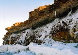
Felsen PakriDie mächtigste Steilküste im Baltikum (bis zu 24 m hoch). In den kalten Winter werden hier phantastische Gletscherstürze entstanden. Pakri Leuchtturm. 50
Services
50km - Distance from countries capital city |
 |
Estonia
Naissaar islandNaissaar is a small island near Tallinn which was exclusively used by the Soviet military from 1945 to 1993. Attractions on the island include walking trails, varied habitats, a narrow-gauge railway, fortifications from the early 20th C, and a Soviet naval mines factory. 12
 1-12 1-12
Services
12km - Distance from countries capital city
1-12 Active season months |
 |
Estonia
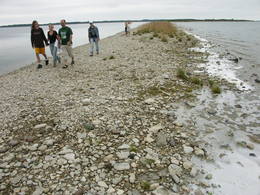
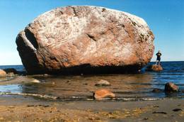
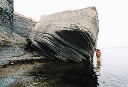
The Letipea Ehalkivi rockThis is the largest rock in the Baltic States and, according to some sources, in all of the segment of Northern Europe which was affected by the last Ice Age. Its size is 930 m3! The rock is 7.5 m high, 16.5 m long and 14 m high, with a circumference of 48.5 m. The rock resembles a huge pebble from a distance, and it is on the sandy and rocky beach. Depending on the season, it can be out in the water. The Ice Age carried the rock to its current location from the southern shore of Finland. It is made of pegmatite.
|
 |
Estonia
Lahemaa Hiking CentreThe Centre promotes sustainable lifestyle and the great outdoors, there you can plant trees and make and install nest boxes. Canoeing, bog walks, bow and crossbow shooting ranges are available for the more adventurous. There is a log house for functions and accommodation and a sauna with a hot tub. 70
1-12
Services
70km - Distance from countries capital city
1-12 Active season months |
 |
Estonia
Anhöhe OtepääOne of the three highlands of Southern Estonia with scenic hills and beautiful sights. In its center lies the bay-rich Lake Pühajärv (translating from Estonian - Holy Lake). 230
Services
230km - Distance from countries capital city |
 |
Estonia
Sõrve säärDie Südspitze der Insel Saaremaa – eine aus Geröll in der Irbenstraße langgestreckte Landzunge. Militärbefestigungen, Leuchtturm (1960), Vogelbeobachtungsort. 270
Services
270km - Distance from countries capital city |
|
|
Estonia
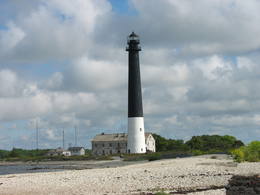
Kap TahkunaDer weiteste Nordpunkt der Insel Hiiumaa. Der höchste Leuchtturm Estlands aus Roheisen (1873 – 1875) und das Denkmal zur Errinerung an die bei dem Unglück des Schiffes ‘Estonia” Umgekommenen. 175
Services
175km - Distance from countries capital city |
 |
Estonia
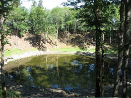
Meteoriten-kraterfeld von KaaliEins der eindrücksvollen Meteoritenkraterfelder Europas. Der Hauptkrater ist 22 m tief, Durchmesser – 110 m. Der ungefähre Zeitraum des Meteoriteneinschlags liegt ung. 7500-Jahre zurück. 205
Services
205km - Distance from countries capital city |
 |
Estonia
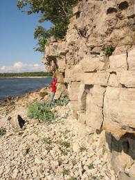
Pakri islandsThere are two islands here – Suur Pakri (Great Pakri) and Väike Pakri (Small Pakri). They are 3 km to the West of Paldiski. During Soviet times, the islands were used for target practice by the Soviet air force, which is seen in the many craters and spent munitions that can be found on the island even today. The island is mostly covered with scrappy areas of juniper, but the limestone cliffs at the northern and north-eastern end of the island are quite impressive – as much as 6 m in height.
|
 |
Estonia
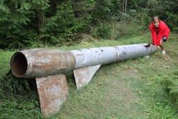
Kap JumindaDer weiteste Nordpunkt der Juminda Halbinsel mit einer Raketen-Attrappe der Sowjetarmee, der alten Grabstätten, dem Juminda-Leuchtturm und einem Denkmal für die Opfern des Zweiten Weltkriegs. 69
Services
69km - Distance from countries capital city |
 |
Estonia
Suitsu tornis (Suitsu torn)Suitsu tornis celts 1979. g. kā pirmais Matsalu rezervāta metāla tornis. To atjaunoja 1998. g. Torņa augstums ir 21 m, tādēļ no tā paveras izcila dabas un kultūrainava uz Kazari deltas niedrājiem un blakus esošo Suitsu upi (Suitsu jõgi), kuras krastā ir uzceltas vairākas zvejnieku laivu būdas. |
 |
Estonia
Skats uz Vaikas salam (Vaika saared)No Vilsandi bākas un tai tuvākās apkaimes ir labi saskatāmas leģendārās Vaikas salas. Tām ir piešķirts rezervāta statuss, tādēļ salas var apskatīt tikai no attāluma. Mazākā no saliņām - Kullipank ir tikai pārdesmit metrus diametrā. Tā ir jūras ūdeņu izrobots zemas un asas dolomīta klints fragments, kas klāts ar oļiem, nelieliem laukakmeņiem un kādu atsevišķi stāvošu lakstaugu. Domājams, ka vētru laikā tā pazūd zem jūras ūdens. Savukārt, Alumine Vaigas – Apakšējā Vaikas sala ir lielākā no sešām salām. Šīs salas diametrs ir ~ 150 m un tā paceļas vismaz kādus divus metrus virs jūras līmeņa. Uz salas ir bagātīga veģetācija un pat kāds zems krūms salas centrā. Redzami arī metru augsti atsegumi. Uz salas vēl joprojām atrodas 20. gs. sākumā celto „putnu māju” paliekas, kas bija domātas ligzdojošo putnu piesaistīšanai. |
 |
Estonia
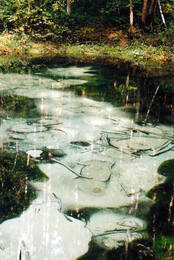
The blue streams of SaulaThree little lakes can be found on the left bank of the Pirita River with many erupting “eyes” of streams, each with its own colour (bluish-green, white, dark). This puts together various colour combinations. These are often known as the most beautiful streams in Estonia. Some pump out as much as 20-30 litres of water per hour. It is said that the waters are good medical resources, particularly for the eyes. There are improvements in the area of tourists.
|
 |
Estonia
Leti tornis (Läti torn)Jēsū – Kepu ceļa malā pie Leti (Läti) ciema ir izveidots autostāvlaukums ar putnu vērošanas torni, no kura paveras skats uz Hallistes upes palieņu pļavām un tuvējā ciema apkārtni. Stipru palu laikā arī no šī torņa redzamā apkārtne (izņemot ceļus) var atrasties zem ūdens. Laba putnu vērošanas vieta. Läti tulkojumā no igauņu valodas nozīmē Latvija. |
 |
Estonia
Kostivere karst fieldThis is one of Estonia’s most beautiful karst fields, covering 125 hectares which feature different karst processes – subterranean streams, the dry Jõelähtme River bed, karst streams, funnels, ditches, caves, cliffs, a unique rock “mushroom,” etc. During the spring, the field is flooded, but at other times of the year, its contents are easily visible.
|
 |
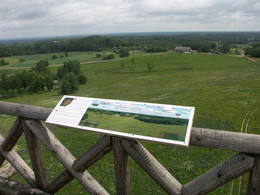
Estonia
The Karula National ParkThis park is in a region of hillocks in the Karula highlands, and Lake Ähijärve is at its centre. The park offers a cultural environment of small farms, and it was set up to protect the unique cupola-shaped hillocks of the area. Main attractions: Scenic Lake Ähijärv (176ha), Rebasemõisa Tornimägi hill (137.8 m above sea level), undulating landscapes. Services
280km - Distance from countries capital cityServices - recreational
Fishing
Bicycle trailBike the route Ähijärve-Peräjärve-Kolski-Rebasemõisa-Kaika-Ähijärve (26 km).
Nature trailHike the Ähijärve nature trail (3.5 km), the Rebase landscape trail (7 km), or the Peräjärve nature trail (4 km).
Nature watchingThere are viewing towers on Tornimägi hill and at Mäekonnu. The visitor centre is in the village of Ähijärve. For more information: www.karularahvuspark.ee (available in English). |
 |
Estonia
Viking villageA unique theme park on the River Pirita evokes interest in ancient Vikings. Facilities include: stronghold, chamber of spells, smithy, Viking boat and dugout canoe trips, shows and battles with ancient weapons, a catapult, archery, axe throwing, cave and smoke saunas, trout fishing, accommodation, catering etc.  30
1-12
30
1-12
Services
30km - Distance from countries capital city
1-12 Active season months |
 |
Estonia
Koiva heritage culture trailThe 60 km cross-border cycling trail along the Koiva/Gauja River in Estonia and Latvia was completed in 2010. The trail begins at Tellingumäe car park, start and finish points of the trail and the border crossing site are supplied with resting areas and information boards with maps. Signposts are located at crossroads where there may be confusion for cyclists; attractions near the main route are also signposted. Information boards are provided in Estonian, Latvian and English. Tellingumäe car park is also a starting point for an 18-km cycling route. 267
1-12
Services
267km - Distance from countries capital city
1-12 Active season months |
|
|
Estonia
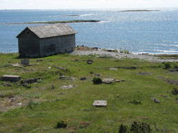
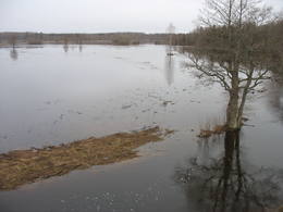
Klostri (Kloostri) skatu tornisMetāla tornis Kazari upes kreisajā krastā, ~ 5 km attālumā no Matsalu līča. No torņa redzamās Kazari deltas palieņu pļavas atrodas tikai 0,3 – 1 m augstumā virs jūras līmeņa, tādēļ pavasara palos un stipru vētru (īpaši rietumvēju) laikā ūdens appludina milzīgu teritoriju. Uzskata, ka platības ziņā šīs ir vienas no lielākajām Eiropas palieņu pļavām, kas ir nozīmīga dažādu tārtiņveidīgo putnu sugu ligzdošanas, dzērvju un zosveidīgo putnu atpūtas un barošanās vieta. Ir pagājis laiks, kad zemnieki Matsalu pļavās ganīja govis un pļāva sienu, tādēļ šobrīd pļavu apsaimniekošanu veic nacionālā parka administrācija. |
 |
Estonia
Ancient Piusa River valley and Piusa caveThe area of the ancient Piusa River valley that is between the villages of Vana-Vastseliina and Ignasõ is around 15 km long, features some substantial rapids, and offers a view of beautiful Devonian period cliffs. The largest, Härma müür, is 43 metres high and is the highest sandstone cliff in Estonia. There are caves from old mines in the village of Piusa. A small part of the mines, which have tunnels that are more than 10 km long in all, has been tured into a local museum.
ServicesServices - recreational
Boat tourBoat from Vana-Vastseliina to Ignasõ (1 day, extreme boating, only during flood season). For more information: www.piusa.ee (available in English).
Nature trailHike down the river valley along its entire length (~20 km). |
 |
Estonia
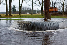
Nemmeveski udenskritums (Nõmmeveski juga)No vairākiem parka ūdenskritumiem noteikti ir jāapmeklē divi. 1,2 m augstais vienpakāpes Nemmeveski ir izveidojies uz Valgejegi upes (Valgejõgi), vietā kur tā šķērso Ziemeļigaunijas glintu. Šeit Valgejegi atgādina krāčainu (īpaši – pavasaros) kalnu upi, kas plūst pa vairākus metrus augstu klinšu ieskautu kanjonu. Palu laikā šo upes posmu ir iecienījuši ekstrēmie ūdenssporta veidu cienītāji. Pie ūdenskrituma un tālāk pa upi lejup redzamas ap 1920. g. celtās hidroelektrostacijas konstrukciju paliekas. |
 |
Estonia
Eldas klints (Elda pank) un pussalaNacionālā parka dienvidrietumdaļā jūrā iestiepjas Eldas pussala – skaists un ļoti omaļš ar kadiķu mežu (alvāriem) noaudzis zemes pleķītis ar interesantu jūras krastu, kur atsedzas silūra perioda nogulumieži. No pussalas gala, kurā slejas vecs Padomju armijas robežsargu tornis (apmeklējumam bīstams!), paveras visaptverošs skats uz Vilsandi salu (atpazīstama pēc bākas), Lonalaidas salu (Loonalaid) – otru lielāko Vilsandi arhipelāgā, Salavu (Salava) un citām mazākām saliņām. Dabas mīļotāji var uzmeklēt Eldas klinti (Elda pank) – ~ 2 m augstu un 0,4 km garu atsegumu, kura piekājē var atrast interesantas ūdens izskalotas fosilijas. 261
Services
261km - Distance from countries capital city |
 |
Estonia
Moorpfad ViruEin 3,5 km langer Pfad quert den Viru Moos in Richtung Süd–Nord. Von einem Holzaussichtsturm eröffnet sich einen Blick auf eine typische Hochmoorlandschaft mit einigen Seen, Aushöhlungen und morastigen Stellen. 56
Services
56km - Distance from countries capital city |
 |
Estonia
Mejekoses pargajienu taka (Meiekose matkarada)~ 3 – 5 km gara taka, kas ved pa veco ceļu gar Tēramā upes (Tõramaa jõgi) kreiso krastu. Takas malās izvietoti interaktīvi elementi bērniem, kas palīdz labāk uztvert dabā notiekošo. Taku ieskauj mitrie meži un palieņu pļavas, kas palu laikā atrodas zem ūdens. Tēramā (Tõramaa) ciemā apkārtnē atrastas cilvēka darbības pēdas jau no akmens laikmeta. 149
Services
149km - Distance from countries capital city |
|
|
Estonia
Skizentrum OtepääDas größte im Baltikum. Marathonloipe von Tartu, Wand der künstlichen Felsen und Trasse der Radmarathon. Skimuseum. Auf der Tehvandi-Sprungschanze ist ein Aussischtsplatform eingerichtet. 225
Services
225km - Distance from countries capital city |
 |
Estonia
Hjupasares pargajienu taka (Hüpassaare matkarada)Iepazīstina ar Somā nacionālā parka lielākā purva – Kureso (Kuresoo) ziemeļaustrumu daļu, kur redzamas purva ezeriņu un lāmu ainavas. Takas sākumā atrodas igauņu komponista, ērģelnieka un folkloras vācēja Marta Sāra (Mart Saar) (1882. – 1963.) dzimtās mājas. To apkaimē pļavas apsaimnieko aitas. Lokveida takas garums ir 4,2 km. 169
Services
169km - Distance from countries capital city |
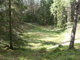 |
Estonia
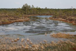
The Ilumetsa meteor cratersThere are three craters here, and the biggest one, known locally as Põrguhaud, or Grave of Hell, has a diameter of 80 m and a depth of up to 12 m. There are barriers around the crater that are several metres high. The other two craters are hard to spot. The craters around 6,000 years old. No scraps of the supposed meteorite have been found, however, and so the origins of the craters cannot be confirmed with certainty.
ServicesServices - recreational
Nature trailThe trail to the Põrguhaud crater is around 700 metres in length. For more information: http://www.ut.ee/BGGM/vaatamis/ilumetsa.html (only in Estonian). |
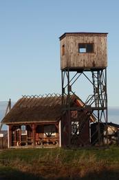 |
Estonia
Kemu skatu tornis (Keemu vaatetorn)Meklējams Matsalu līča dienvidu krastā pie Kēmu ostas (Keemu sadam). Blakus sešus metrus augstajam metāla – koka tornim uzcelts neliels apmeklētāju centrs. Tāpat kā no Haeskas torņa, arī no šī paveras viena no izcilākajām Matsalu līča un tā piekrastes ainavām. Laba putnu vērošanas vieta migrāciju laikā. 129
Services
129km - Distance from countries capital city |


