
Dabas objekti Igaunijā

Ar ko ievērojama daba Igaunijā?
Iespaidīgākā Baltijas klinšu siena – t.s. Ziemeļigaunijas glints, „Līču zeme” – Lahemā ar nacionālo parku, „Salu zeme” – Sāremā sala un Monzunda salu arhipelāgs, Matsalu līcis kā viena no nozīmīgākajām masveida putnu atpūtas vietām migrāciju laikā, viens no izcilākajiem Eiropas meteorīta krāteriem, izcilākie Baltijas dižakmeņi un ūdenskritumi, Munameģis – Baltijas augstākā virsotne, Peipuss – piektais lielākais Eiropas ezers – ar senām zivju ieguves tradīcijām un ārkārtīgi lielā dabas daudzveidība, kas ir acīmredzami mainīga gan austrumu – rietumu, gan ziemeļu – dienvidu virzienā, ir tikai dažas no Igaunijas valsts dabas pievilcībām.
Lai uzzinātu vairāk par apmeklējamām teritorijām aicinām izmantot vides vai vietējo gidu pakalpojumus. Esiet saudzīgi pret dabu ceļojuma laikā - ievērojiet Zaļos padomus!
| Pārskats | Detaļas |
|---|---|
 |
Igaunija
Pakri salasDivas salas – Lielā Pakri (Suur Pakri) un Mazā Pakri (Väike Pakri) - 3 km R no Paldiskiem (Paldiski). Padomju laikā tās izmantoja kā armijas aviācijas poligonu, par ko liecina daudzās bumbu bedres un munīcijas paliekas. Salas klāj g.k. retas kadiķu audzes, bet to Z, ZA galos paceļas iespaidīgas līdz 6 m augstas kaļķakmens klintis.
|
 |
Igaunija
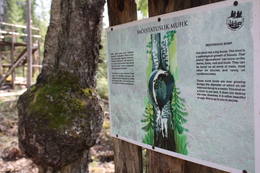
Kūranīdu mācību taka (Kuuraniidu õpperada)1,7 km gara lokveida taka, kas iepazīstina ar dažādiem meža biotopiem, to iemītniekiem un meža apsaimniekošanas pamatprincipiem. Apmeklētāju ērtības nolūkā ir izveidotas koka laipas un neliels skatu tornis.  159 159
Pakalpojumi
159km - Attālums no valsts galvaspilsētas |
 |
Igaunija
Otepää slēpošanas centrsLielākais Baltijas valstīs. Tartu maratona trase, mākslīgo klinšu siena un velomaratorna trase. Slēpju muzejs. Tehvandi tramplīnā – skatu platforma. 225
Pakalpojumi
225km - Attālums no valsts galvaspilsētas |
|
|
Igaunija
Hiiumaa salaOtra lielākā Igaunijas sala ar plašiem mežu masīviem, smilšainām un akmeņainām pludmalēm un vienu no Eiropas vecākajām bākām. 132
Pakalpojumi
132km - Attālums no valsts galvaspilsētas |
 |
Igaunija
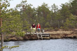
Ērdi taka (Öördi rada)1,2 km gara taka, kas pa purvainu mežu aizved līdz Ērdi purvam (Öördi raba) un tā austrumu daļā esošajam Ērdi ezeram (Öördi järv), pie kura izveidota atpūtas un peldvieta. |
 |
Igaunija
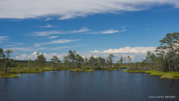
Tolkuse purvsCauri purvam un augstākajam Igaunijas kāpu masīvam izveidota izziņas taka. Skatu tornis ar skatu līdz pat Kihnu salai. 175
Pakalpojumi
175km - Attālums no valsts galvaspilsētas |
 |
Igaunija
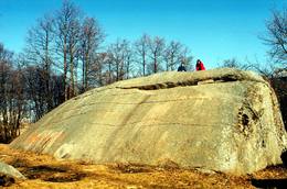
Mūgas Kabelikivi akmensPēc tilpuma (728 m3) - otrs lielākais Baltijas dižakmens. Baltijā vienīgais akmens ar šādu formas un izmēra apvienojumu. Tā augstums ir 7 m, garums – 19 m, platums – 11 m, bet apkārtmērs – 58 m. Kabelikivi atgādina līdz pusei zemē ieraktu milzu klints gabalu. Ledājs to „atnesis” no Somijas D daļas. Pēc sastāva - rapakivi granīts. Tam blakus atrodas vēl 2 visnotaļ iespaidīgi dižakmeņi.
|
 |
Igaunija
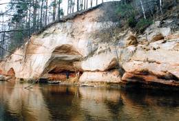
Vehandu upes senlejaViena no skaistākajām Igaunijas upju senlejām – 12 km gara ar gandrīz 40 ainaviskiem Devona perioda smilšakmens atsegumiem, no kuriem īpaši jāpiemin Viira müür, Kalamatu müür un Põdramüür.
|
|
|
Igaunija
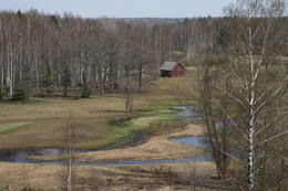
Lemmjē pārgājienu taka (Lemmjõe matkarada)Taka, kas izveidota Lemmjegi (Lemmjõgi) un Raudnas (Raudna jõgi) satekas vietā, iepazīstina ar palieņu pļavām un veciem pārmitriem mežiem, kas ir vieni no lielākajiem Igaunijā. Takas sākumā dominē atklātas lauku ainavas. Viens no 4,9 km garās lokveida takas apskates objektiem ir Lemjē dižozols. Mitrā laikā noderēs ūdensizturīgi apavi. 155
Pakalpojumi
155km - Attālums no valsts galvaspilsētas |
 |
Igaunija
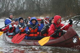
Piedzīvojumi 360°Uzņēmums nodarbojas ar dabas tūrisma pasākumu organizēšanu: vasarā laivošana ar kajakiem jūrā, rudenī – pārgājieni ar sniega kurpēm pa purvu, ziemā – pārgājieni ar sniega kurpēm, un pavasarī – laivošana ar kanoe laivām pa upēm. Dabas draugiem piedāvā tematiskas ekskursijas: pavasarī – lāču vērošanas safari un putnu vērošana, rudenī – aļņiem, roņiem un vilkiem veltīti tematiskie pasākumi. 37
 1-12 1-12
Pakalpojumi
37km - Attālums no valsts galvaspilsētas
1-12 Aktīvie sezonas mēneši |
 |
Igaunija
Oksas (Oksa) takaBijušā piecstāvīgā metāla skatu torņa apkaimē plešas Lemmjegi upes palieņu pļavas. Netālu atrodas kādreizējā Oksas kroga (Oksa kõrts) vieta, kur saglabājies iespaidīgs manteļskurstenis. Apkaimes apskatei izveidota 0,8 km gara koka laipu taka. 175
Pakalpojumi
175km - Attālums no valsts galvaspilsētas |
 |
Igaunija
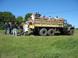
Kūsnemmes pussala (Kuusnõmme poolsaar)Ap 6 km garā pussala ir vieta, kur jānokļūst tiem, kas grasās doties vienā no neparastākajiem pārgājieniem pāri jūras šaurumam. Cauri Kūsnemmes pussalai līdz tās ziemeļu daļai iet šaurs un ļoti līkumains grants ceļš (ar garāku tūristu autobusu jābrauc lēni un uzmanīgi), kura galā izveidots autostāvlaukums, neliels namiņš, kur patverties lietus un vēja laikā, kā arī informācijas stends. Turpat redzamas divas Padomju armijas „KRAZ” tipa automašīnas. Lai sasniegtu robežkontroles posteni, Padomju robežsargi brauca pa jūru un mazajām saliņām, kas kā pērļu virtene savieno Kūsnemmes pussalas galu ar Vilsandi salas dienviddaļu. Turpat divas desmitgades pēc Igaunijas neatkarības atjaunošanas „KRAZ” automašīnu kravas kastēs vasaras laikā uz Vilsandi vizināja tūristus, taču spēkrati savu mūžu ir nokalpojuši un unikālais piedāvājums vairs nav spēkā! Ko darīt? Pa mazajām saliņām uz Vilsandi var doties ar kājām. To var īstenot tikai siltā laikā, kad nav gaidāms stiprs vējš un ir zināma laika prognoze vismaz divām tuvākajām dienām. Kā sava veida orientieris var kalpot augstsprieguma elektrolīnija. Kopumā ir jārēķinās arī ar 1 h 40 – 2 h ilgu un ~ 4 km garu gājienu. Dziļākā vieta (ja ietur pareizo „kursu”) atrodas pārgājiena sākumdaļā, kur starp saliņām izveidots laivu ceļš - ~ 1 m dziļa vieta atkarībā no vēja virziena un ūdens līmeņa. Zināmu priekšstatu par maršrutu sniegs redzamā ainava, kas paveras no skatu torņa. Kaut arī šis maršruts tiek reklamēts dažādos informatīvajos materiālos, atbildību par tā veikšanu uzņemas katrs pats! 257
Pakalpojumi
257km - Attālums no valsts galvaspilsētas |
 |
Igaunija
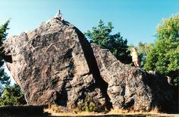
Jāņa - Toma akmens (Jaani - Tooma kivi)Neticami! Tā saka tie, kuri Ziemeļigaunijas dižāko akmeņu apzināšanu ir sākuši ar šo ledāja atnesto gigantu! Jāņa – Toma akmens kopā ar vēl diviem milžiem - Tammispeas akmeni (Tammispea kivi) un Ehalkivi (atrodas netālu no Kundas) pretendē uz Baltijas augstāko dižakmeņu (augstums sasniedz gandrīz 8 m) godu! Kaut arī pēc tilpuma (274 m3) tas ierindojas tikai Igaunijas lielāko akmeņu saraksta 14. vietā, arī pārējie izmēri (garums: 13,9, platums – 7,3 m, apkārtmērs – 35 m) ir gana iespaidīgi. Jāņa – Toma akmens ir meklējams Kasispeas (Kasispea) ciemā, neliela kadiķu lauka malā. 72
Pakalpojumi
72km - Attālums no valsts galvaspilsētas |
 |
Igaunija
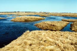
Kostiveres karsta lauksIgaunijas vizuāli izteiksmīgākais karsta lauks 125 ha platībā ar dažādām karsta procesu izpausmēm – pazemes strautiem, Jēlehtmes (Jõelähtme) upes sausgultni, karsta avotiem, piltuvēm, gravām, alām, pamatiežu atsegumiem, savdabīgu akmens „sēni” u.c. Pavasaros tas applūst, bet mazūdens periodā labi apskatāmas minētās karsta formas.
|
 |
Igaunija
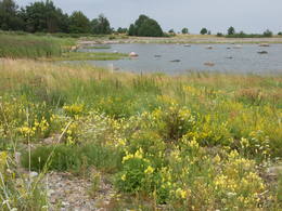
Aegnas salaViscaur mežiem klāta sala Somu līcī ~ 14 km Z no Tallinas. Salu caurauž nelielu ceļu un taku tīkls. Ieteicams pārgājiens apkārt mainīgajai (kāpas, smilšaini, akmeņaini un ar niedrēm apauguši krasta posmi) salas piekrastei (~ 9 km). Kuģītis atiet no Piritas ostas.
|
 |
Igaunija
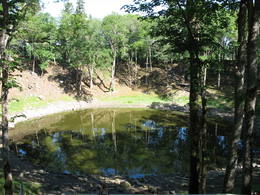
Kaali meteorīta krāterisViens no Eiropas iespaidīgākajiem krāteru laukiem. Galvenā krātera dziļums ir 22 m, diametrs – 110 m. Meteorīts nokritis pirms ~ 7,5 tūkstošiem gadu. 205
Pakalpojumi
205km - Attālums no valsts galvaspilsētas |
 |
Igaunija
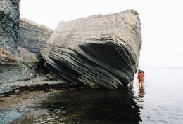
Pangas klintisSāremā salas augstākā (līdz 21 m), iespaidīgākā un ainaviskākā klinšu siena, kas stiepjas ~ 3 km garumā. Stipra R, ZR vēja laikā tās nelielu posmu apskalo jūras viļņi. Atsegumu veido Silūra perioda kaļķakmeņi, merģeļi un dolomīti, tādēļ to piekājē izskalots bagātīgs fosiliju klāsts – koraļļi, galvkāji, stromatopori u.c.
|


