
Nature objects in Estonia

What's special about the nature in Estonia?
In Estonia, there stands the most impressive rock wall in the Baltics - the so called North Estonian "glint" (from Estonian language). Estonia has its own "Land of Inlets" - the Lahemaa region with its national park, the "Land of Islands" - the Saaremaa island and the Monzund archipelago. The Matsalu bay is one of the most significant rest stops for birds during their migration. In Estonia there is one of the most prominent impact craters in Europe, there are the greatest waterfalls and boulders in the Baltics, the Munamagi hill - the highest spot in the Baltics, the Lake Peipus - the 5th largest lake in Europe, - with long-standing fishing traditions, and the great variety of nature from West to East, from North to South.
Act responsibly - follow the Green advice!
| Overview | Details |
|---|---|
 |
Estonia
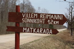
Paunas taka (Pauna rada)Kultūrvēsturiska taka (garums ~ 2 km) Tipu (Tipu) ciemā, kas iepazīstina ar vairākiem interesantiem objektiem: veco skolu (1931. g.), Hallistes upi, pirti un Paunas saimniecību, kurā dzimis viens no Igaunijas nacionālās kustības līderiem Villems Reimans (1861. – 1917.). |
 |
Estonia
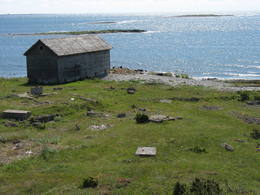
Piirissaar islandThe island of 7.5 km2 in Lake Peipsi is largely inhabited by Russian-speaking Old Believers who have broadly retained their old traditions through time. Traditional trades are fishing and growing vegetables, mainly onion.  262 262
 1-12 1-12
Services
262km - Distance from countries capital city
1-12 Active season months |
 |
Estonia
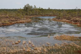
Hjupasares pargajienu taka (Hüpassaare matkarada)Iepazīstina ar Somā nacionālā parka lielākā purva – Kureso (Kuresoo) ziemeļaustrumu daļu, kur redzamas purva ezeriņu un lāmu ainavas. Takas sākumā atrodas igauņu komponista, ērģelnieka un folkloras vācēja Marta Sāra (Mart Saar) (1882. – 1963.) dzimtās mājas. To apkaimē pļavas apsaimnieko aitas. Lokveida takas garums ir 4,2 km. 169
Services
169km - Distance from countries capital city |
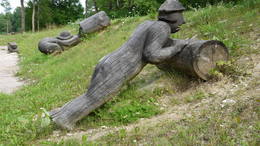 |
Estonia
Theme park of GothamitesThe theme park of wise men of Gotham (Kilpla) is located in Müüsleri village; the park’s attractions arise from legends told in Germany some 400 years ago. Gothamites are funny characters famous for their irrational, impractical and foolish actions. Fun-packed tours and activities are on offer along with craft workshops, themed souvenirs, catering (groups should book in advance), and grounds for pitching tents. 107
1-12
Services
107km - Distance from countries capital city
1-12 Active season months |
 |
Estonia
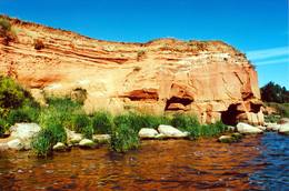
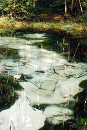
The sandstone cliffs of KallasteThis is one of the few places in the Baltic States where one can find Devonian period sandstone cliffs featuring abrasion caves, arches, etc. The cliffs are on the shores of Lake Peipsi (Peipsi järv), near Kallaste, and they are between two and four (in some cases – nine) metres high, stretching for a distance of around one km.
ServicesServices - recreational
Nature trailHike along the shores of the lake to and from the cliffs (3 km). 
Nature watchingThere is a viewing tower which offers a good look at Lake Peipsi and the shoreline. For more information: www.kallaste.ee (only in Estonian). |
 |
Estonia
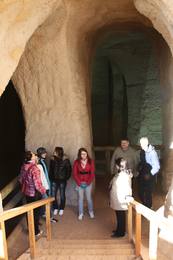
Ancient Piusa River valley and Piusa caveThe area of the ancient Piusa River valley that is between the villages of Vana-Vastseliina and Ignasõ is around 15 km long, features some substantial rapids, and offers a view of beautiful Devonian period cliffs. The largest, Härma müür, is 43 metres high and is the highest sandstone cliff in Estonia. There are caves from old mines in the village of Piusa. A small part of the mines, which have tunnels that are more than 10 km long in all, has been tured into a local museum.
ServicesServices - recreational
Boat tourBoat from Vana-Vastseliina to Ignasõ (1 day, extreme boating, only during flood season). For more information: www.piusa.ee (available in English).
Nature trailHike down the river valley along its entire length (~20 km). |
 |
Estonia
Abruka IslandThis is the 11th largest Estonian island, and its central section is covered by a broadleaf forest (linden, oak, elm and other trees) that is more than 100 years old. Along the shores, the Abruka Island has meadows and small areas of wetlands. Only the northern part of the island is populated. Few tourists come to call, which means that the island is relatively untouched by humankind.
ServicesServices - recreational
Nature trailHike across the island or along its NE shoreline (7 km). For more information: www.abruka.ee (available in English).
Nature watching |
 |
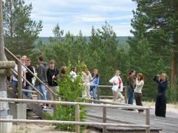
Estonia
The Lahemaa National ParkThis is the first national park in Estonia and the Baltic States. Perfect for a day trip out from Tallinn for a hiking trip and nature watching. It was established in 1971 to protect the area that is along the Bay of Finland – the shoreline, forests, swamps, meadow biotopes, species, natural monuments, rocks, waterfalls, cliffs and cultural monuments such as ancient cemeteries, castle hills, baronial estates, fishing villages, etc. Services
50km - Distance from countries capital cityServices - recreational
Cross-country skiingFor cross-country skiers, the Käsmu peninsula is perfect during the season. 
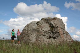
Bicycle trailFor bikers, there’s the Käsmu peninsula (~10 km), the route Loksa-Pärispea-Viinistu-Kasispea on the Pärispea peninsula (here you will find the highest rock in the Baltic States – the Jaani-Tooma rock (kivi, 7.8 metres high).
Nature trailYou can hike a wooden train over the Viru swamp (Viru raba, 3.5 km), another trail on the Käsmu peninsula (~15 km), and the Pikanõmme-Majakivi trail (4.5 km), along which you will find the third largest rock in the Baltic States – the so-called House Rock (Majakivi), which has a size of 584 m3. We also suggest the informational Altja trail (3 km).
Nature watchingThere are viewing towers in the Viru raba swamp and along the Piaknõmme-Majakivi trail. There is a visitor centre at Palmse. |
 |
Estonia
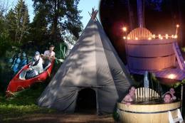
Reimann RetkedThe company runs wildlife tours: rafting in early spring, kayaking in summer (with beaver watching upon request), bog and snowshoeing round the year, kick-sledging in winter. Our experienced guides tell exciting stories of wildlife and history. 34
1-12
Services
34km - Distance from countries capital city
1-12 Active season months |
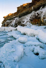 |
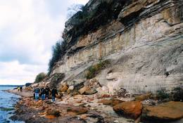
Estonia
Pakri peninsulaAt the end of the Pakri peninsula is the most visually impressive shoreline cliff in the Baltic States – the Pakri cliff (Pakri pank), which is as much as 24 metres high. During cold winters, streams which flow from the layers of limestone cliffs form fantastic and unusual shapes of ice.
|
 |
Estonia
LuitemaaIn Estonian, Luitemaa means ‘the land of dunes’. It is the seashore territory of the Gulf of Pärnu, 13 km between Vöiste and Häädemeeste with shallow waters, vast coastal meadows, the highest dune range in Estonia and the Tolkuse Mire (Tolkuse raba). The Tolkuse mire trail (~2.2 km) and watching tower are available for dune and mire sightseeing tours. Situated in Luitemaa Nature Reserve. |
 |
Estonia
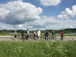
The Otepää Nature ParkThis park is found in the Otepää highlands and offers an outstanding example of how the terrain of a protected natural territory can be used for recreation, sports and active leisure. The infrastructure of the park is perfect for such activities and is of a high level of quality.
ServicesServices - recreational
Cross-country skiingDuring the winter, you can ski the 63-km Tartu marathon trail, which crosses the park.
Bicycle trailBike around Lake Pühajärv from the centre of Otepää (~20 km), or ride from Otepää to Kääriku (11 km).
Nature trailHike around Lake Pühajärv (12 km), hike the Kekkose hiking route (14 km), or hike the Murrumetsa hiking trail (3.5 km). Bike around Lake Pühajärv from the centre of Otepää (~20 km), or ride from Otepää to Kääriku (11 km).
Nature watchingThere are viewing towers at Harimägi and in the hills of Kuutsemägi, near the Otepää ski jump, at Väike Munamägi, and near the Otepää castle hill. For more information: www.otepaaloodus.ee (available in English). |
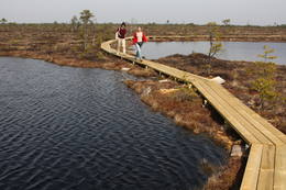 |
Estonia
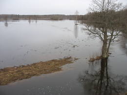
The Soomaa National ParkThe word “Soomaa” means “land of the swamps” in Estonian. There are several major swamps in this area, along with rivers, lowland meadows, wetland forests, and other biotopes that are of key importance in terms of the diversity of species. Major floods occur here in the spring, which is known by locals as the “fifth season''. The fifth season is the best time to explore the landscape of Soomaa. Services
150km - Distance from countries capital city
1-12 Active season monthsServices - recreational
Fishing
Cross-country skiingDuring the winter, there is cross-country skiing and hikes across frozen swamps. The visitor centre is in Tõramaa. For more information: www.soomaa.com (available in English).
Boat tourCanoeing is possible on flooded territories and down the rivers of the park.
Nature trailWalking tours in the park
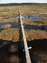
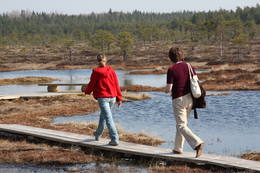
Nature trailHike the area in the presence of a guide, go “bog-shoeing”, hike the Riisa swamp trail (5 km, with watching tower), the Ignatsi trail (4.5 km, with watching tower), the Beaver information trail (3 km), the Tõramaa trail (2.5 km, with watching tower), and other trails and routes in the park.
Nature watchingYou can go on a beaver safari and look for other animals in the company of a guide. |
 |
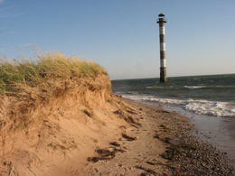
Estonia
Skats uz Vaikas salam (Vaika saared)No Vilsandi bākas un tai tuvākās apkaimes ir labi saskatāmas leģendārās Vaikas salas. Tām ir piešķirts rezervāta statuss, tādēļ salas var apskatīt tikai no attāluma. Mazākā no saliņām - Kullipank ir tikai pārdesmit metrus diametrā. Tā ir jūras ūdeņu izrobots zemas un asas dolomīta klints fragments, kas klāts ar oļiem, nelieliem laukakmeņiem un kādu atsevišķi stāvošu lakstaugu. Domājams, ka vētru laikā tā pazūd zem jūras ūdens. Savukārt, Alumine Vaigas – Apakšējā Vaikas sala ir lielākā no sešām salām. Šīs salas diametrs ir ~ 150 m un tā paceļas vismaz kādus divus metrus virs jūras līmeņa. Uz salas ir bagātīga veģetācija un pat kāds zems krūms salas centrā. Redzami arī metru augsti atsegumi. Uz salas vēl joprojām atrodas 20. gs. sākumā celto „putnu māju” paliekas, kas bija domātas ligzdojošo putnu piesaistīšanai. |
 |
Estonia
LuitemaaThe word “Luitemaa” means “land of the dunes” in Estoninan. This coastline territory stretches for 13 km between Vöiste and Häädemeste with shallow waters, large coastal plains, Estonia’s highest dunes, and the Tokuse swamp (Tokuse raba). There are lots of birds here.
|
 |
Estonia
Lahemaa Hiking CentreThe Centre promotes sustainable lifestyle and the great outdoors, there you can plant trees and make and install nest boxes. Canoeing, bog walks, bow and crossbow shooting ranges are available for the more adventurous. There is a log house for functions and accommodation and a sauna with a hot tub. 70
1-12
Services
70km - Distance from countries capital city
1-12 Active season months |
 |
Estonia
Ehijervs (Ähijärv)Karulas nacionālā parka lielākais ezers - 2,8 km garš, līdz 1 km plats. Ezera ziemeļaustrumu krastā atrodas parka apmeklētāju centrs. 5,5 m dziļais ezers ir gan zivīm, gan nostāstiem bagāta vieta. Ezera un tuvākās apkārtnes iepazīšanas nolūkā ir izveidota 3,5 km garā Ehijerva taka (Ähijärve teerada). Tās sākums atrodas pie iepriekš minētā apmeklētāju centra, kur izveidota atpūtas vieta un atraktīvs bērnu spēļu laukums. Taka sākumā ved gar ezera krastu, nelieliem mitrājiem un meža ceļiem, kas izmantoti iepriekšējos gadsimtos. |
 |
Estonia
The Endla ReserveThis reserve was set up to protect local swamps and surrounding wetlands. Please note that before you can visit the reserve, you must register with the local administration and visitor centre in the village of Tooma.
ServicesServices - recreational
Nature trailThe Endla swamp trail (~2 km) with a viewing tower, and the Endla stream trail (6 km). Please note that before you can visit the reserve, you must register with the local administration and visitor centre in the village of Tooma. For more information: www.endlakaitseala.ee (available in English). |
 |
Estonia
Mekonnu skatu tornis (Mäekonnu vaatetorn)Viens no diviem nacionālā parka skatu torņiem, kas atrodas ~ 1,5 km ziemeļos no Ehijerva ezera (Ähijärv). Tornis ir veiksmīgi „nomaskēts” nelielā priežu pudurī, tādēļ tas „nebojā” izcilo dabas un kultūrainavu, kas paveras no tā skatu platformas. Pie autostāvlaukuma ir izveidota labiekārtota atpūtas vieta. |
 |
Estonia
Turisalu cliffThis cliff is made of sandstone (its lower part) and limestone (the upper part). It is up to 30 m high, and it is part of the Northern Estonian set of cliffs along the shore of the Bay of Finland. This is a popular tourism destination and viewing location. Recommended Hike along the bottom of the cliff (a rocky beach) in one direction, and then along the top of the cliff to get back (~2 km). From the top of the cliff, you can see a broad segment of the shoreline territory, all the way to Tallinn.
|
 |
Estonia
Tuhala Nature Centre and NõiakaevTuhala region has settlements of about 3000 years of age. There are 11 ancient settlement sites, 30 cult stones, 3 burial sites, 4 sacred groves, etc. Tuhala Landscape Reserve has a unique natural feature - the Nõiakaev (Witch´s Well) which “boils” up water during floods at 100 l/s, and 5 mightiest energy columns of the country. 32
1-12
Services
32km - Distance from countries capital city
1-12 Active season months |
 |
Estonia
Perajerva meza taka (Pärajärve metsarada)Četrus kilometrus gara marķēta lokveida taka, kas ved pa lielāku meža masīvu, iepazīstina ne tikai ar augiem un dzīvniekiem, bet arī mežsaimniecības tradīcijām. Takas sākums atrodas pie nelielā Perejerves ciema, uz kuru paveras labs skats no tuvējā paugura. Pie autostāvlaukuma izveidota atpūtas un piknika vieta. |
 |
Estonia
Halbinsel PärispeaAuf der Küste der Halbinsel befinden sich sowohl ehemalige Fischerdörfer, als auch die Reste eines Militärstützpunkts der Sowjetarmee. Großartige von den Gletschern des Eiszeitalters eingebrachte Feldsteine. 74
Services
74km - Distance from countries capital city |
|
|
Estonia
Anhöhe OtepääOne of the three highlands of Southern Estonia with scenic hills and beautiful sights. In its center lies the bay-rich Lake Pühajärv (translating from Estonian - Holy Lake). 230
Services
230km - Distance from countries capital city |
 |
Estonia
The blue streams of SaulaThree little lakes can be found on the left bank of the Pirita River with many erupting “eyes” of streams, each with its own colour (bluish-green, white, dark). This puts together various colour combinations. These are often known as the most beautiful streams in Estonia. Some pump out as much as 20-30 litres of water per hour. It is said that the waters are good medical resources, particularly for the eyes. There are improvements in the area of tourists.
|
 |
Estonia
Tihuse Riding Farm heritage trailTihuse farm provides accommodation and horse riding from trekking to carriage rides. A signposted heritage trail starts at the farm and tells the story of people and Nature; you can also learn about old beliefs and customs. The teahouse exhibits photos of places linked to Muhu island’s heritage. 148
1-12
Services
148km - Distance from countries capital city
1-12 Active season months |
 |
Estonia
Leti tornis (Läti torn)Jēsū – Kepu ceļa malā pie Leti (Läti) ciema ir izveidots autostāvlaukums ar putnu vērošanas torni, no kura paveras skats uz Hallistes upes palieņu pļavām un tuvējā ciema apkārtni. Stipru palu laikā arī no šī torņa redzamā apkārtne (izņemot ceļus) var atrasties zem ūdens. Laba putnu vērošanas vieta. Läti tulkojumā no igauņu valodas nozīmē Latvija. |
 |
Estonia
Risas purva taka (Riisa rabarada)Izcila lokveida taka (4,5 km), kuras lielākā daļa (koka laipas) ved pa Rīsas purvu (Riisa raba). No takas un divstāvīgā koka skatu torņa ir vērojami purva ezeriņi, lāmas, un purvaini meži. Ja nacionālā parka apskati sāk no ziemeļu puses, tad šī taka ir labs ceļojuma iesākums! |
 |
Estonia
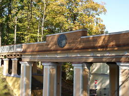
Domberg TartuVom 19. Jh. ist der Domberg ein offentlicher Park mit Pfaden, Gehwegen, Brücken (Engelsbrücke, Teufelsbrücke) und den Denkmälern für die Wissenschaftler der Tartu Universität. Hier befinden sich die Domkirche, das Anatomicum, das Observatorium u.a. interessante Objekte. 185
Services
185km - Distance from countries capital city |
 |
Estonia
Harilaidas pussala (Harilaid)Sāmsalas ziemeļrietumu daļā jūrā iestiepjas iespaidīgā Tagameizas pussala (Tagamõisa poolsaar). Tās ziemeļrietumu daļā meklējama mazāka – ap 5 km garā Harilaidas pussala (Harilaid). Pussalas vidusdaļā viļņojas Lajalepas ezers (Laialepa järv) - bijušais jūras līcis, kas zemes garozai ceļoties, kļuvis par iekšēju ūdenstilpi. Arī pati Harilaida (igauniski „laid” nozīmē „saliņa”) vairāk nekā trīs gadsimtus atpakaļ bijusi sala. Harilaidu iecienījuši ne tikai migrējošie putni, bet arī roņi, kurus piesaista vientuļi līči un akmeņainās sēres. Harilaidu var apmeklēt tikai ar kājām vai ar divriteni, bet spēkrati ir jāatstāj autostāvlaukumā. No tā ~ 1 km attālumā atrodas vieta, kur pēc 17. gs. radies Harilaidas savienojums ar Sāmsalu. Šeit paveras nepierasti klaja un akmeņaina ainava. Pārējā Harilaidas daļa ir apmežota pirms ~ 40 gadiem. Kopumā būs jāveic ~ 10 km garš pārgājiens. 273
Services
273km - Distance from countries capital city |


