
| No | Name | Description |
|---|---|---|
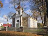 |
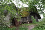
St. John the Baptist Roman Catholic Church of Nagļi was built
in 1862 by landlord Nābels. Some time ago, Nagļi Church was a branch of Viļāni Church. The Bernardian
monks served there. After the closing of the cloisters in 1930s, the church was served by priests.
|
|
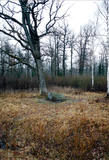 |
This territory was established to protect the lovely central section of the Neries River, local species, and Lithuania’s largest oak forest.
|
|
 |
The café is in the centre of Balvi on the side of Brīvības Street (in the direction of Viļaka). It offers homemade dishes and is a popular dining venue. |
|
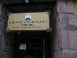 |
Karaims are a small nation of Turkish decent who practise The Karaim religion which started developing around 8th century in Persia. Their language is still used in modern-day Lithuania. In the museum there are rooms not only dedicated to Lithuanian Karaite communities but also Poland's and Ukraine's. |
|
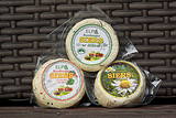 |
For more than 20 years the company has been partnering with some 100 local suppliers of milk. Its main principle is to offer healthy dairy products, including kefir, cottage cheese, cream, yogurts and soft cheese. SIA Elpa is the only dairy processing company in Southern Kurzeme that offers tours and tastings of products. Products can be bought, and during the tours, visitors can taste kefir, cheese and yogurt and help with the dairy processing process themselves. |
|
 |
The farm on the banks of the River Navesti is Estonia's largest company engaged in the cultivation and processing of organic medicinal herbs. The farm has an education and health path of medicinal herbs, open from May to September. The Energy Eco-Spa offers holiday, conference and accommodation services with a sauna. Spa experience is with local, ecologically grown herbs together with clay, peat and natural plant oils. Baths, wraps and massages help the body to function naturally and holistically. All the products are natural and fresh and are prepared just for you immediately before the treatment. Farm has a tea house completed in 2010 which is suitable for holding seminars, relaxing and in the summertime also for having meals. Herb presentations are held there - first on the field and then in the tea house. There is also a 13-metre viewing tower by the river from which you can get a good overview of the lands of the farm. |
|
 |
The saloon is on the edge of the Murjāņi-Valka road (A3) in a two-story log building with a terrace. The interior design of Mazais Ansis fits the aura of a massive wooden structure and it is possible to look at old times’ instruments, household goods and harnesses. There is also a very valuable wooden wheel, which is one of the very few in Latvia. The saloon offers a sauna, a location for campfires and a children’s playground. It works with local farmers and manufacturers. Latvian cuisine: Valmiera salad, boiled tongue, grey peas, farmer’s breakfast, cold soup, filet of pike, roast lamb, grilled pork, stacked rye bread, strawberry crème with jam, rye bread, herbal teas. Special foods: Beef filet with potato pancakes. |
|
 |
Mailīšu fabrika atrodas Ērgļos, un tā ir radīta ar mērķi saglabāt rokdarbu tradīcijas un prasmes. Te auž vilnas, lina un zīda darbus - segas, plecu lakatus, linu dvieļus. Viesiem ir iespēja apskatīt dažādu veidu stelles, kuras izmantotas Latvijas teritorijā jau sākot no 9.gs. |
|
 |
Das größte Wissenschaftszentrum Baltikums mit Möglichkeiten, mitzuarbeiten und zu experimentieren. Ein Planetarium. |
|
 |
Centre stage on the a la carte menu of the restaurant is devoted to premium quality game meat dishes. Fish lovers will enjoy just caught Siberian sturgeon in the Sangaste Loss pond, ensuring that ingredients are always fresh. Ancient cooking techniques, such as baking on a bonfire in natural smoke, are honoured. |
|
 |
Maza apdzīvota vieta ar dažām viensētām uz pussalas (salos tulkojumā no lietuviešu valodas nozīmē „sala") starp vairākiem ezeriem. Salos II ir viens no sešiem Augštaitijas nacionālā parka etnogrāfiskajiem ciemiem. Ciems patiks tiem, kas meklē ļoti nomaļas vietas ar vecām guļbaļķu dzīvojamām un saimniecības ēkām. No Salos II pa sauszemes maršrutu var doties pārgājienā līdz Ladakalnim un Ginuču pilskalnam (sk. iepriekš). |
|
 1 day
|
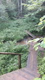
The Forest Trail leads down from the highest point of the Haanja Upland. The most important sight on this route is the Suur Munamägi Hill – 318 m above sea level. The highest point of the Baltics with its observation tower provides its visitors with a splendid 50 km range view of the Estonian nature. The 150 year-old western taiga spruce forests grow on the slopes of Suur-Munamägi. Further on the trail circles around the southern part of Lake Vaskna, and continues down small country roads surrounded by solitary homesteads and small clusters of farms. The route ends in a small village, Tsiistre, where the Linen Museum is located. The museum has a collection of folk linen. Flax is one of the oldest cultural plants in Estonia and a few decades ago, blue flax fields were a common sight in southern Estonia. |
|
 |
Saimniecība ir neliela un atrodas laukos, klusā vietā. Līdz ar to pilnīgi dabiski tiek nodrošināta mierīga un relaksējoša saskarsme un darbs ar zirgiem. Piedāvā izjādes ar diviem zirgiem, organizējam sacensības pajūgu braukšanā. Vasaras periodā nodrošina zirgiem pansiju. Atrodas tikai 4,5 km no valsts nozīmes A9 ceļa Rīga- Liepāja un 16 km attālumā no Rīgas Zoodārza filiāles „Cīruļi”. Vasarā ir ugunskura vieta, nakšņošanas iespējas teltīs. |
|
 |
Prepares dishes from local Latvian products. The menus are changed every season, meaning that the guests can enjoy seasonal dishes. The 360-degree glazed terrace offers a picturesque view of Rose Square, in the heart of Cēsis City. |
|
 |
Guest house "Ausmas" is located in Valka region, and can accommodate up to 30 people. Catering services are also available both on site and off-site. Guests have access to a wet sauna, as well as a sauna ritual with a skilled bather. The guest house organizes various events, as well as tours and groups of children. There is also an animal farm on the farm, where children can feed and love a variety of animals. The owners actively cooperate with the neighboring farms. The owners of the guest house are home-grown producers who offer guests a variety of smoked meats, cheeses and homemade bread. Master classes are offered in both cheese tying and bread baking. It is possible to visit and organize tastings both with home-made products and with the offer of the surrounding farms. |
|
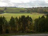 |
As you travel from Kandava to Sabile, you will find a parking lot on the right side of the road. From there, there are steps to a viewing area on the highest hill in the Abava Ancient River Valley – Greiļi Hill. This offers a wonderful view of the ancient river valley and the local mosaic of meadows and forests. The landscape is enriched by the Imula and Amula valleys that are on the other side of the ancient river valley.
|
|
 |
"Mākoņmalas" is located in the middle of the forest, in silence. A magical place where you can enjoy SPA procedures and sauna rituals, gain knowledge in magical and non-traditional practices, as well as be alone with nature, improve health, enjoy a "short vacation for the hurried and busy". In "Cloud Edges" you will receive a restart for both body and soul. After the procedures, it is possible to enjoy a deep night's sleep in our home and taste the early breakfast on the terrace, watching the morning rituals of wild animals and the beauty of nature. You can enjoy the morning with a stick or a regular morning walk through the forest to meet deer and other forest dwellers. |
|
 |
Šis avots ir pazīstams kopš seniem laikiem. Kalpo kā laba dzeramā ūdens ņemšanas vieta. |
|
 |
Kaļķis is a populated area where
dolomite is still extracted from quarries in
the region (Kalnciems2 is one such
quarry). Some of the quarries are flooded.
|
|
 |
This is a comparatively large lake (3 km long and 1.3 km wide). It is shallow (no more than 1.1 m deep) and is classified as a seashore lake. The Vecslocene River flows through it. At the southern end, there is a narrow stream which connects Lake Sloka with Aklo Lake – a shallow and small lake with a dolomite bed at some locations. The best view of Lake Sloka can be seen from the bird watching tower on its north-western shore. This is the only floating bird watching tower in Latvia. Alongside it is the beginning of the 3 km Lake Sloka hiking trail, which passes through the flooded wetlands of the lower reaches of the Vēršupīte. An information stand can be found on the shore of Lake Sloka by the car park. Beyond it is a sulphurous spring. |
|


