
| Нo | Название | Описание |
|---|---|---|
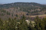 |
This park was set up to protect the landscape and cultural environment of the Haanja highland. At the central part of the park are the two highest hills in the Baltic States – Suur Munamägi, which stands 318 m above sea level, and Vällamägi, which is 304 m above sea level. The ancient Rõuge River valley (Rõuge ürgorg) is found in the western part of the park. It is 7.5 km long and up to 60 m deep. The valley dates back to the Ice Age, and it has seven lakes, including the deepest one (38 m) in Estonia – Lake Rõuge Suurjärv.
|
|
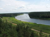 |
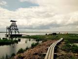
По количеству природных ресурсов, ландшафтов, биологического разнообразия и памятников культуры – один из самых богатых и ландшафтно самых необычных природных парков Латвии, главная «ценность» которого – это практически нетронутая долина среднего течения Даугавы с восьмью большими излучинами (длина 4 – 8 км) и оврагами ее притоков. Великолепные виды открываются с крутых берегов Даугавы, в частности с обрывов Слутишкю и Верверу, а также с гравийной горы Элернес. На берегах долины находятся более двух десятков различных памятников археологии, древние городища – Науенес, Марковас, Вецрачинас и др., многочисленные храмы – Юзефовас, Спрукту, Боровкас, Элернес, Сикелес, Каплавас и др., поместья (Розалишкю, Лиелборнес и др.), а также уникальная обжитая старообрядческая деревня Слутишки, в которой для посетителей создана музейная экспозиция. На территории парка находятся также интересные природные тропы, велосипедные маршруты, можно отправиться в поход на лошадях. Недавно в Краславе была построена новая современная смотровая вышка. Увлекателен спуск по Даугаве на лодках. Природный парк входит в состав большей особо охраняемой природной территории – в охраняемую ландшафтную местность Аугшдаугавы. |
|
 |
The park was established to protect the Venta River valley and the landscapes that are around its tributaries. On the west bank of the Venta, at Papilė, there is a cliff from the Jurassic period which is unique in the Baltic States, has been known since 1925, and has layers in which more than 300 forms of life have been identified over the course of time.
|
|
 |
Доле является самым большим островом на Даугаве. С северо-востока его омывают быстрые воды Даугавы, а с юго-запада – спокойные и понемногу зарастающие воды бокового русла Даугавы. Острову присвоен статус природного парка (Особо охраняемая природная территория). Парк основан в 1987-м году с целью сохранения оставшегося после постройки Рижской ГЭС ландшафта острова и культурно-исторических ценностей, а также редких и охраняемых видов растений и животных. Еще одна цель образования парка – способствование просвещению и отдыху общества. Одним из известнейших объектов осмотра острова Доле является музей Даугавы, размещенный в жилом здании поместья Доле. В коллекции музея находятся ~ 13 000 различных экспонатов – свидетелей истории острова Доле и берегов Даугавы – одежда балтов и ливов, орудия труда, предметы быта. Экспозиция знакомит с историей Даугавы как значимого водного пути, а также с историей плотовщиков и транспортных средств этого пути. В парке поместья Доле размещена музейная экспозиция под открытым небом с реконструкцией заколов для миног и запруды для ловли лосося и коллекцией рыболовных снастей. Возле музея на обрывистом берегу бокового русла Даугавы находится доломитовое обнажение. На юго-востоке острова на берегу Даугавы возле хутора Бечи можно осмотреть руины замка Вецдоле. |
|
 |
Kauņas jūras reģionālais parks (Kauno marių regioninis parkas) dibināts 1992. gadā. Tas ietver Nemunas HES uzpludināto posmu – lielāko Lietuvas ūdenskrātuvi no Kauņas līdz Piļonas (Piliuona) ciemam. Viena no nozīmīgākajām parka vērtībām ir ainava, kas veidojusies ilgā cilvēka un dabas mijiedarbībā. Parkā konstatētas 950 augu sugas, 600 dzīvnieku, t.sk. - 34 zivju sugas. Parka nozīmīgas dabas vērtības ir meži, augstie purvi, kadiķu audze. Parkā ir apskatāmi dažādu vēsturisko periodu liecinieki – senču pilskalni, Pažaislis klosteris, Kauņas cietokšņa Piektais forts, kā arī Rumšišķes (Rumšiškės) brīvdabas muzejs – viens no lielākajiem (195 ha) šāda veida muzejiem Eiropā. Vaišvīdavā (Vaišvydava) ir izveidots parka apmeklētāju centrs, parkā ir dabas takas, piemēram, Žiegždriai ģeoloģiskā taka un Dubravos izziņas taka. |
|
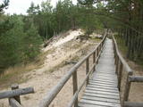 |
По всей своей протяженности тропа выстлана деревянными мостками. Она извивается то вверх, то вниз, вдоль крутых берегов низовья Пилсупе и приоткрывает красивые виды на три белых песчаных обнажения (самое крупное из них и есть Белая дюна). Окрестный дюнный массив образовался в период Литоринского моря нескольких тысяч лет тому назад. В окрестностях тропы найдены свидетельства поселения эпохи каменного века. Необходимое время для осмотра тропы примерно полчаса. |
|
 |
The tower is on the banks of the little Tērvete River, with a view of the river valley and surrounding forests. Good views of the Tērvete River valley are also available from the nearby Zviedru Hill and the Tērvete castle hill. Note: The viewing tower at the Tērvete Ancient History Museum is not open to visitors!
|
|
 |
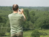
An important complex of the coastline and its sand dunes along with the mouths of three major rivers – the Lielupe, the Daugava and the Gauja. This area has ancient traditions of recreation and spa services. The territory has lovely shoreline landscapes and features one of the few coastline meadows in Latvia. The nature park includes several restricted areas – the meadows of the Lielupe estuary, Vakarbuļļi, Daugavgrīva, Vecdaugava and Ummis (see the section on “Restricted Natural Areas”). Interesting elements of nature in this area include the amphitheatre of the Garciems dunes, along with individual dunes such as the Legzdiņi dune and the so-called ski mountain dune. Visitors will be attracted by various cultural and historical monuments – fortifications on the Mangaļi peninsula, military buildings from the period of the Russian tsars all the way through the late period of the Soviet occupation, the fortress of Daugavgrīva, the Vecāķi spa with its old shoreline buildings, and the beaches at Daugavgrīva and Vecāķi. The proximity of the city of Rīga and various important recreational resources are the reason for the massive anthropogenic burden that is placed on this territory. The nature park is appropriate for active tourism (hiking, bicycling, boating, driving), distance skiing, nature and bird-watching, cultural tourism, passive leisure and educational tourism. There are nature trails at Daugavgrīva and the Rožu dunes, along with other elements of infrastructure. |
|
 |
Городище Бусе (Маткулес) находится в изгибе берегов реки Имула. С него, на противоположный берег Имулы открывается один из самых живописных видов на речушки Курземе. Видом лучше всего любоваться в безлистный период, когда ландшафт не закрывает береговая растительность. С правого берега великолепный вид на долину Имулы открывается также по дороге к городищу рядом с домом Бусе. |
|
 |
The forests of Zvārde are located on land which used to be a Soviet air base. The territory was unpopulated and was not accessible to civilians. The vast area includes various types of forest - boreal forest, bogs of black alder, etc. The fact that the military used to control the territory is one of the reasons why the forests of Zvārde are a location where many rare and protected birds live, reproduce and find food. Some of the elements of the old air base are still in place, including a unique surveillance platform. It is recommended that visitors to the area drive only along general use roads. |
|
 |
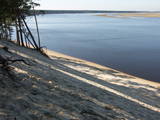
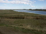
The key treasure in this park is that it has a lake that is one of the most intensive sites for birdwatchers in all of Latvia. It also features outstanding flora and the shallow waters of the Bay of Rīga. Recommended: Hike along the seashore from Mērsrags to Engure (20 km). See wild domestic animals (horses and cows) on the eastern shore of Lake Engure. There’s a bird-watching tower on the NW shore of the lake (approach from Kūļciems, where you can see domestic animals adapted to life in the wild, including the Blue Cows of Latvia). A bird-watching tower can be found at a place called Jomiņa near Mērsrags, where the seashore meadow is an uncommon biotope
|
|
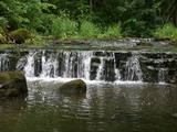 |
The ancient Abava River Valley between Kandava and the place where the river flows into the Venta River is the most expressive river valley segment in Kurzeme in terms of landscape and terrain. The valley is 30 to 40 metres deep and as much as 300 metres wide. The territory is distinguished by great diversity of a biological nature (more than 800 kinds of plants), featuring many different biotopes and natural monuments such as streams, waterfalls, cliffs, huge rocks, and many cultural and historical monumentssmall towns such as Kandava and Sabile. In both cases, the town centres are national monuments of urban construction. Popular tourist destinations include Vīnakalns hill in Sabile, where wine-making grapes are grown, as well as the open-air art museum at Pedvāle. To protect cultural treasures, a cultural and historical territory, “Abava River Valley” has been established. Wild livestock live at Drubazas and Tēvkalni to “maintain” the landscape. There are nature trails for tourists, and the Abava is the most popular river for water tourists in Kurzeme. Information is available at the tourist information centres in Kandava and Sabile. such as castle hills, churches, ancient burial grounds, and
|
|
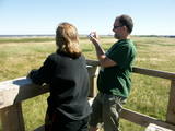 |
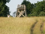
The viewing tower is in a seaside meadow near Mērsrags. It is an unusual type of biotope in Latvia and is located to the North of the Mērsrags port. The tower offers a good view of reed-filled meadows, areas where wild cattle have grazed, and an amazing wealth of different kinds of plants. |
|
|
|
Tītuvēnu reģionālais parks (Tytuvėnų regioninis parkas) dibināts 1992. gadā. Parkam raksturīga ainavu daudzveidība – te ir sastopami lieli mežu masīvi, purvi, ezeri, upītes. Šejienes reljefa veidotājs tāpat kā citur Baltijas valstīs ir bijis ledājs, kas atnesis un atstājis aiz sevis garas laukakmeņu grēdas. Kopumā parkā ir konstatētas 603 augu un 787 dzīvnieku sugas. Parkā aug veci un dabiski boreālie (ziemeļu) meži, veci un jaukti platlapju meži ar ozoliem, liepām, kļavām, ošiem un gobām, sugām bagāti egļu meži, staignāju meži, nogāžu un gravu meži, purvaini meži un aluviālie (pārplūstošie) meži. Parkā esošās pļavas un tīrumi ir nozīmīga dzērvju atpūtas vieta migrāciju laikā, kad te pulcējās tūkstošiem putnu. Šiluvas baznīca un Tītuvēnu klosteris ir svētceļnieku galamērķis vairāk nekā 500 gadu garumā. |
|
 |
One of the most important locations for migrating water birds in terms of rest and feeding in Latvia is the Svēte flood-land, which overflows in the spring time, along with the Svēte polder. It has been calculated that when circumstances are good, tens of thousands of birds can be seen in the area – swans, geese, corn-crakes, pintails, predatory birds, plover-type birds, etc. |
|
 |
Engures apkaimē aug 22 no Latvijā sastopamajām 32 orhideju dzimtas sugām .Lai dabas parka apmeklētājiem dotu iespēju aplūkot šīs interesantās augu sugas, ierīkota Orhideju taka. Kopējais takas garums ir 3.5 km, tā sākas netālu no Engures Ornitoloģisko pētījumu centra, līkumo caur kalcifilajiem purviem un mežam putnu novērošanas torņa virzienā, un aizvijas tālāk gar atjaunoto ezera piekrastes pļavu, kurā mīt govis un zirgi. Takas sākumā novietotajā informācijas zīmē attēlotas ne tikai apkārtnē sastopamās orhidejas. Tur iespējams gūt daudzpusīgu informāciju arī par citām interesantām Engures ezera dabas parka augu sugām.
|
|
 |
This park was established to protect Lithuania’s longest lake, Lake Asveja (> 20 km). The lake is in a sub-glacial valley carved out by ice during the Ice Age, and it actually resembles a wide and curvy river.
|
|
|
|
10 km garais pārgājienu maršruts iepazīstina ar vienu no vēl retajiem, cilvēka mazāk ietekmētajiem Daugavas senlejas posmiem. Tā sākums – Aizkraukle, finišs – Skrīveri. Gar upes krastu izvietotas atpūtas vietas. Maršrutu var braukt arī ar velosipēdu. |
|
 |
Here the visitor will find an ecological tourism trail in the ancient Embūte valley. The hills around Embūte date back to the Ice Age. There are valleys and forests of many fallen trees which are protected habitats. The visitor will learn about important natural and cultural monuments – the Embūte castle hill, as well as the ruins of a baronial estate, a castle and a church. The Courlandian chieftain Indulis died in the region. The visitor can view the Devil’s Dam, along with meadows, a viewing tower, etc. There are bicycler routes in the region. The site is located in the Embūte nature park. |
|
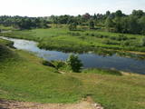 |
The Bauska Nature Park runs for several dozen kilometres along the Lielupe River and its tributaries – the Mūsa and the Mēmele. This is a protected territory. The shores of these rivers contain some of the largest dolomite cliffs in Zemgale. These are protected both as biotopes and as geological monuments. The rivers are important places for river lampreys and vimbas to spawn. Tourists will be attracted by the cultural landscape of the area, as well as the cultural monuments such as the Bauska castle, the Jumpravmuiža park, the Mežotne castle hill, Vīna Hill, the Mežotne castle, etc. The rivers are used for water tourism. |
|


