
| Нo | Название | Описание |
|---|---|---|
 |
Latvia’s highest hill is the second highest in the Baltic States, but alas, it has only a wrecked viewing tower, so you’ll have to look for the best views on your own. You’ll find some around the tower and the ski trails, particularly Large and Small Golgotha. It is worth hiking the Gaiziņkalns nature trail.
|
|
 |
Ārkārtīgi ainaviska teritorija Augšzemes augstienes centrālajā daļā ar vairākiem ezeriem - Medumu, Lielo un Mazo Ilgas, Šķirsteņu un dažām mazākām ūdenstilpēm. Medumu ezera salām ir dabas lieguma statuss. Teritoriju šķērso vairāki grantēti ceļi, no kuriem dažviet paveras brīnišķīgas, bet nelabiekārtotas skatu vietas. Teritorijā atrodas Medumu katoļu baznīca. Piemērota teritorija dažādu aktīvā tūrisma veidu attīstībai. Dabas parks ietilpst Augšzemes aizsargājamo ainavu apvidū. |
|
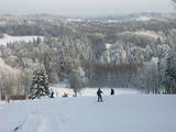 |
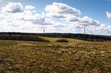
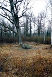
Gaiziņkalns Hill is the highest hill in Latvia, and it is a typical example of the hillocks of the Vidzeme highlands. This is a place of wonderful landscapes, even though there are not all that many good viewing areas. At the centre of this park is Gaiziņkalns Hill itself – the highest place in Latvia and the second highest in the Baltic States (311.6 metres above sea level). The viewing tower, alas is not open to the public, because it is in dangerous condition. There is a well-appointed hiking trail around Gaiziņkalns Hill, and during the winter the hill and its surroundings are popular for downhill and cross-country skiing. Lake Viešūrs (Lake Kaķītis) is popular among licensed fishermen. This territory is part of a region of protected landscapes around Vestiena. |
|
 |
Engures apkaimē aug 22 no Latvijā sastopamajām 32 orhideju dzimtas sugām .Lai dabas parka apmeklētājiem dotu iespēju aplūkot šīs interesantās augu sugas, ierīkota Orhideju taka. Kopējais takas garums ir 3.5 km, tā sākas netālu no Engures Ornitoloģisko pētījumu centra, līkumo caur kalcifilajiem purviem un mežam putnu novērošanas torņa virzienā, un aizvijas tālāk gar atjaunoto ezera piekrastes pļavu, kurā mīt govis un zirgi. Takas sākumā novietotajā informācijas zīmē attēlotas ne tikai apkārtnē sastopamās orhidejas. Tur iespējams gūt daudzpusīgu informāciju arī par citām interesantām Engures ezera dabas parka augu sugām.
|
|
 |
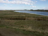
No ģeogrāfiskā un kultūrvēsturiskā viedokļa interesanta teritorija Latgales augstienes Rāznavas paugurainē, kuras nozīmīgākie resursi ir dažāda veida biotopi, ainavas, reljefs un Šķaunes ezers. Istras pauguraines dabas parkā nav ar tūrismu saistīti labiekārtojumi, bet šo teritoriju var apskatīt arī „no malas”, braucot pa grantēto ceļu no Soboļinas uz Osinovku, kas iet līdztekus parka ziemeļu robežai (skats uz Šķaunes ezeru).
|
|
 |
This is a small area with lots of different terrains – high hillocks, distinct river valleys, thermal streams, continental dunes, etc.
|
|
 |
One of the most important locations for migrating water birds in terms of rest and feeding in Latvia is the Svēte flood-land, which overflows in the spring time, along with the Svēte polder. It has been calculated that when circumstances are good, tens of thousands of birds can be seen in the area – swans, geese, corn-crakes, pintails, predatory birds, plover-type birds, etc. |
|
 |
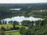
Богатое заливами и полуостровами озеро Цириш (находится в Циришском природном парке) украшено несколькими островами, наибольший из которых - Упурсале укрыл в листве своих деревьев городище древних латгалов – Упуркалнс. У подножья обнаружены свидетельства древних поселений и найдены черепки посуды, каменное долото и другие предметы. На берегу восточной части острова устроена лодочная пристань лодок, а вокруг острова проложена благоустроенная природная тропа. |
|
 |
We recommend that you walk through the town of Kandava not only to enjoy the charm of a small town, but also to find fantastic viewing locations where you can see the town and the shores of the ancient Abava River valley from the Kurši (Ancestor) castle hill, Lielā Street, the Bruņinieki castle hill and Zīļu Street (School Hill), as well as from the area of the Ozolāji open-air stage.
|
|
 |
This park is found in the Otepää highlands and offers an outstanding example of how the terrain of a protected natural territory can be used for recreation, sports and active leisure. The infrastructure of the park is perfect for such activities and is of a high level of quality.
|
|
 |
The “backbone” to this park is the valley of the Šventoji (Holy) River. One of the most impressive Devonian cliffs in Lithuania can be seen from the river – Vetygalos atodanga. On the shores of the Varius stream is a cliff made of quartz and sand – Variaus atodanga. 6 km to the S of Anykščiai is Lithuania’s second largest rock (5.7 m high, ~100 m3) – Puntukas akmuo.
|
|
 |
This lovely territory includes the hillocks of Embūte, which are in the ancient Embūte valley. The aim of establishing the park was to protect the landscape, biotopes and species of the region. An ecological tourism trail has been established in the valley, as has a forest trail through the nature park (accessibly only in the company of a guide). Visitors will learn about the hillocks and ravines left behind by the Ice Age. The ravines and the forests along their sides are protected biotopes. There are also important natural and cultural monuments, including the Embūte castle hill and the ruins of a baronial estate, castle and church. Other points of interest include the death place of the Courlandian warrior Indulis, the Joda dam, meadows, a viewing tower, etc. Three unmarked bicycle trails are in the area. |
|
|
|
The viewing tower is on the western part of the Blue Hills of Ogre, not far from the Dubkalni quarry. Paths lead to the tower, as does a wooden staircase. The viewing platform offers a very broad view of the Ķegums hydroelectric power plant reservoir and the towers of
|
|
 |
This territory was established to protect the lovely central section of the Neries River, local species, and Lithuania’s largest oak forest.
|
|
 |
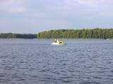
This territory is rich with forestland and lakes (some 285 in all). There are extensive opportunities for active recreation or calm leisure.
|
|
 |
10 km garais pārgājienu maršruts iepazīstina ar vienu no vēl retajiem, cilvēka mazāk ietekmētajiem Daugavas senlejas posmiem. Tā sākums – Aizkraukle, finišs – Skrīveri. Gar upes krastu izvietotas atpūtas vietas. Maršrutu var braukt arī ar velosipēdu. |
|
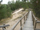 |
По всей своей протяженности тропа выстлана деревянными мостками. Она извивается то вверх, то вниз, вдоль крутых берегов низовья Пилсупе и приоткрывает красивые виды на три белых песчаных обнажения (самое крупное из них и есть Белая дюна). Окрестный дюнный массив образовался в период Литоринского моря нескольких тысяч лет тому назад. В окрестностях тропы найдены свидетельства поселения эпохи каменного века. Необходимое время для осмотра тропы примерно полчаса. |
|
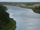 |
This lovely part of the Nemuna River between Alytus and Pakuonis meanders through cliffs that are up to 40 m high.
|
|
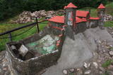 |
Науенское городище находилось на крутом правом берегу долины Даугавы на высоте 25 м, между двумя оврагами. Под руководством магистра Ливонского ордена Эрнеста фон Раценбурга в 1275 - 1277 гг. на месте прежнего латгальского деревянного замка возводится каменный замок. До середины XVI века замок служит резиденцией комтура Динабурга. В 1577 году войска Ивана Грозного полностью разрушили замок. После этого события Динабург теряет свое стратегическое значение, и строительство новых укреплений начинается в том месте, где сейчас находится Даугавпилс.Рядом с развалинами замка ордена установлен уменьшенный макет замка. С места автостоянки до городища можно дойти по тропе. С городища открывается один из красивейших видов на изгибы Даугавы. |
|
 |
The Sunset trail starts in the centre of Saulkrasti town and takes you to the White Dune. Saulkrasti town with its municipal rural territory, occupies a 17km long stretch of coastal land to the North from the river Lilaste and the lake Lilaste. The White Dune stands on the right side of river Inčupe mouth. It is covered by old pine forest. The white, 18m high sand outcrop in olden times served as a landmark for fishermen. The White Dune formed as winds carried the sand from the beach over clay sediments of the Baltic Ice Lake. Some 150-200 years ago, the dune had been drifting as witnessed by several layers of soil buried within it. Local fishermen and farmers at Bātciems initiated afforestation of the drifting dunes. At that time, the 30m high dunes which are now covered with forest, were bare, shifting and even buried a farmstead. To speed up afforestation, mountain pines were planted. The White Dune was partly washed away in heavy storm in 1969, and 4-6m high precipice formed. Now the wind and sand have levelled out the dune surface, it has been fixed with willow-twigs or grown with forest where the largest pines are more than 170-190 years old. The pines are notable with their large trunks and branches, the scars obtained during their lifetime and the typical “crocodile skin” – the bark forms rhombuses resembling those of the reptile’s scales. Scots Pine (Pinus Silvestris) is one of the most common tree species in Latvia. It grows in dry, meagre sandy soil in dunes as well as in marsh. However, it does not stand overshadowing. Forest fires help pines to get rid of competitors as pine endures fire better than other trees because of its thick bark and high crown. The wood exudes resin and burned wounds close soon. Fire cleans space for seedlings of young pines. Pines can live 300-350 years. Ground cover in dune forests is very sensitive. If the sparse vegetation is destroyed, not only the natural biodiversity and landscape is damaged, but also the dangerous shifting dunes can possibly “wake up”. Embryonic dunes, White (yellow) dunes, Grey dunes and Wooded dunes are EU protected biotopes. Grey Dunes are protected by Latvian law as well. |
|


