
| Nr | Name | Beschreibung |
|---|---|---|
 |
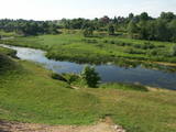
The park was established to protect the Venta River valley and the landscapes that are around its tributaries. On the west bank of the Venta, at Papilė, there is a cliff from the Jurassic period which is unique in the Baltic States, has been known since 1925, and has layers in which more than 300 forms of life have been identified over the course of time.
|
|
 |
Eine schöne malerische Flussstrecke zwischen Alytus und Pakuoni, wo der Fluss mehrere breite Mäanderkrümmungen mit bis zu 40 m hohen Mörenenabdeckungen macht (Balbieriškio-Abdeckung u.a.). |
|
 |
Die Wälder von Zvārde befinden sich auf einem ehemaligen sowjetischen Luftstützpunkt. Das Gebiet war nicht bewohnt und für Zivilisten nicht zugänglich. Auf dem riesigen Gelände gibt es verschiede Waldarten – Nadelwald, Schwarzerlensümpfe usw. Die Tatsache, daß das Militär dieses Gebiet kontrolliert hat, ist der Grund dafür, daß in den Wäldern von Zvārde viele seltene und geschützte Vögel leben, brüten und Futter finden. Einige Teile des alten Luftstützpunktes sind noch vorhanden, wie z.B. eine Überwachungsstation. Es wird empfohlen, daß sich Besucher nur auf den allgemein benutzten Straße bewegen.
|
|
 |
Riežupes dabas parks veidots g.k. Riežupes izteksmīgās ielejas, tai raksturīgo dabas vērtību – nogāžu un gravu mežu, dažādu ģeoloģisku dabas pieminekļu - smilšakmens atsegumu, alu, ūdenkritumu, upes straujteču posmu, dažādu sugu, mežu masīvu un ainavas aizsardzībai. Parka atrodas viens no Kurzemes populārākajiem tūrisma objektiem – Riežupes alas - garākais mākslīgo alu labirints Latvijā, kura eju kopgarums ir 460 m. Sākotnēji dabas veidotās alas 19. gs. vidū mākslīgi paplašināja baltās smilts ieguves nolūkos, kuras izmantoja stikla ražošanai. Parkā izveidots velotūrisma maršruts. |
|
 |
Tītuvēnu reģionālais parks (Tytuvėnų regioninis parkas) dibināts 1992. gadā. Parkam raksturīga ainavu daudzveidība – te ir sastopami lieli mežu masīvi, purvi, ezeri, upītes. Šejienes reljefa veidotājs tāpat kā citur Baltijas valstīs ir bijis ledājs, kas atnesis un atstājis aiz sevis garas laukakmeņu grēdas. Kopumā parkā ir konstatētas 603 augu un 787 dzīvnieku sugas. Parkā aug veci un dabiski boreālie (ziemeļu) meži, veci un jaukti platlapju meži ar ozoliem, liepām, kļavām, ošiem un gobām, sugām bagāti egļu meži, staignāju meži, nogāžu un gravu meži, purvaini meži un aluviālie (pārplūstošie) meži. Parkā esošās pļavas un tīrumi ir nozīmīga dzērvju atpūtas vieta migrāciju laikā, kad te pulcējās tūkstošiem putnu. Šiluvas baznīca un Tītuvēnu klosteris ir svētceļnieku galamērķis vairāk nekā 500 gadu garumā. |
|
 |
Der Bauska Naturpark verläuft für mehrere Dutzend Kilometer am Lielupe-Fluß und an seinen Nebenflüssen – der Mūsa und der Mēmele – entlang. Das ist ein geschütztes Territorium. Die Ufer dieser Flüsse enthalten einige der größten Dolomitklippen in Zemgale. Diese sind sowohl als Biotop als auch als geologisches Denkmal geschützt. Die Flüsse sind wichtige Laichplätze für Flussneunaugen und Zährten. Touristen werden von der Kulturlandschaft des Gebietes beeindruckt sein, genau wie von den Kulturdenkmälern wie z.B. vom Schloß Bauska, dem Park Jumpravmuiža, dem Mežotne - Burgberg und - Schloß, dem Vīna - Berg usw. Die Flüsse sind für Wassertourismus geeignet.
|
|
 |
It is rare type of lake in Latvia and there are only of few this type of lakes in Kurzeme region. The lake is characterized by high water limpidness (very attractive for tourists) and very rare plant species for Latvia. Nature park includes the lake, costal area and forest on the East from the lake, few smaller lakes and Sarlote Pond. There are several tourist accommodations located around the lake.
|
|
 |
Ārkārtīgi ainaviska teritorija Augšzemes augstienes centrālajā daļā ar vairākiem ezeriem - Medumu, Lielo un Mazo Ilgas, Šķirsteņu un dažām mazākām ūdenstilpēm. Medumu ezera salām ir dabas lieguma statuss. Teritoriju šķērso vairāki grantēti ceļi, no kuriem dažviet paveras brīnišķīgas, bet nelabiekārtotas skatu vietas. Teritorijā atrodas Medumu katoļu baznīca. Piemērota teritorija dažādu aktīvā tūrisma veidu attīstībai. Dabas parks ietilpst Augšzemes aizsargājamo ainavu apvidū. |
|
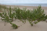 |
Ein Gebiet zwischen Palanga und Klaipeda, gegründet für den Schutz der Dünen und Biotopen der Küstenwälder. Ein asphaltierter Radweg läuft durch das Gebiet. |
|
 |
Zur Besichtigung steht die Umgebung der bis zu 17 m hohen Düne Ragakāpa un 100-jährige Kiefern. Entfernung ~2km (einfache Richtung!). Sie liegt im Naturpark Ragakāpa.
|
|
 |
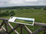
Engures apkaimē aug 22 no Latvijā sastopamajām 32 orhideju dzimtas sugām .Lai dabas parka apmeklētājiem dotu iespēju aplūkot šīs interesantās augu sugas, ierīkota Orhideju taka. Kopējais takas garums ir 3.5 km, tā sākas netālu no Engures Ornitoloģisko pētījumu centra, līkumo caur kalcifilajiem purviem un mežam putnu novērošanas torņa virzienā, un aizvijas tālāk gar atjaunoto ezera piekrastes pļavu, kurā mīt govis un zirgi. Takas sākumā novietotajā informācijas zīmē attēlotas ne tikai apkārtnē sastopamās orhidejas. Tur iespējams gūt daudzpusīgu informāciju arī par citām interesantām Engures ezera dabas parka augu sugām.
|
|
 |
The most important aspects of this park are a shallow lagoon-type lake – Lake Pape, with its flood land meadows, the shore of the Baltic Sea, the Nida swamp, and the more than 270 different types of birds that have been spotted here. The oldest bird ringing station in Latvia (est. 1966) is found between Lake Pape and the Baltic Sea. Birds and bats are caught and ringed there. Lake Pape is the first place in Latvia where so-called “wild” horses (the “Konik” breed) were released with the aim of managing the flood land meadows.
|
|
 |
The “backbone” to this park is the valley of the Šventoji (Holy) River. One of the most impressive Devonian cliffs in Lithuania can be seen from the river – Vetygalos atodanga. On the shores of the Varius stream is a cliff made of quartz and sand – Variaus atodanga. 6 km to the S of Anykščiai is Lithuania’s second largest rock (5.7 m high, ~100 m3) – Puntukas akmuo.
|
|
 |
This park is in a region of hillocks in the Karula highlands, and Lake Ähijärve is at its centre. The park offers a cultural environment of small farms, and it was set up to protect the unique cupola-shaped hillocks of the area. Main attractions: Scenic Lake Ähijärv (176ha), Rebasemõisa Tornimägi hill (137.8 m above sea level), undulating landscapes. |
|
 |
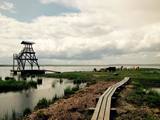
An der rechten Uferbiegung an der Mündung der Inčupe erhebt sich die bis zu 18 m hohe weiße Düne, die malerischste Ausgestaltung von Wind, Sand und Meer an der Küste der Rigaer Bucht - ein alter Orientierungspunkt der Seefahrer. Ein Stegpfad mit Aussichtsplattform. Das Gebiet südlich von Inčupe liegt im Naturpark Piejūra.
|
|
|
|
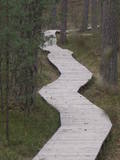
1,8 km garā taka atrodas neparastā vietā – uz Cirīša ezera salas. Tās galvenās vērtības ir augu valsts un dzeņveidīgo putnu daudzveidība. Viens no apskates objektiem ir Upurkalns – sens pilskalns. Taka labiekārtota, izveidoti informācijas stendi, atpūtas vieta. Lai nokļūtu uz salas, no vietējiem jānomā laiva, vai jādodas ar savējo. Atrodas dabas parkā „Cirīša ezers”. |
|
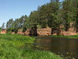 |
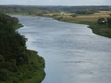
Dieser Park ist ein Gebiet, das vom Menschen kaum verändert wurde – Sandsteinklippen, verschiedene Höhlen, Biotope, Arten und Landschaften sind der attraktive Aspekt dieses Gebietes. Der Salaca-Fluss ist einer der wichtigsten Flüsse in der Ostseeregion als Laichgebiet für den Lachs, und es ist der zweitwichtigste Fluss für Wassertourismus in der lettischen Region von Vidzeme. Hier gibt es geologische Denkmäler, die für Besucher besonders attraktiv sind – Die Roten Klippen, der Skaņais-Berg, die Neļķu-Klippe, die Velna-(Teufels) Höhle usw. Hier sind auch solche Kulturdenkmäler wie der Livische Burgberg, der Vecsalaca - Gutshof, das Livische Museum, das Vantenberģi - Anwesen, die einzigartigen Neunaugen - Stauwehre usw. Im Park befindet sich auch eins der beliebtesten touristischen Ziele in Nordvidzeme – der Skaņākalna-Park, der ein dichtes Netz von Wanderpfaden hat. Der Salaca ist auch beliebt bei Fischern. Dies ist Teil des Nordvidzemer Biosphärenreservats.
|
|
 |
There are three large lakes at the centre of this park – Lake Dusia, Lake Metelys, and Lake Obelija. Lake Dusia has very clear and transparent water, and its southern and south-eastern beaches are popular among swimmers. The lakes and their nearby wetlands are important during the migration season of birds.
|
|
 |
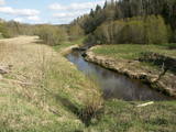
This is a small area with lots of different terrains – high hillocks, distinct river valleys, thermal streams, continental dunes, etc.
|
|
|
|
Ap 9 km garā taka (vienā virzienā) sākas Skaņākalna dabas parkā (Mazsalacā) un beidzas pie Ramatas. Tā iepazīstina ar Salacas ielejas dabas parka nozīmīgākajām vērtībām – smilšakmens atsegumiem (Skaņaiskalns, Dauģēnu klintis u.c.), alām, nozīmīgu izmēru laukakmeņiem u.c. Taka marķēta. Tajā izvietoti informācijas stendi, norādes. Jāpadomā par loģistiku – kā nokļūt sākuma punktā. |
|


