
| No | Name | Description |
|---|---|---|
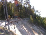 |
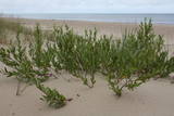
This nature park covers an area of the Baltic Sea coast and part of newly established sea protected area "Nida - Pērkone" with sand dunes which once used to move around but have now settled. These are the highest dunes in Latvia. Visitors will enjoy the coastal landscape, sandy beaches and small fishing villages of the area. A nature trail has been established on Pūsēni Hill (one of the highest dunes in Latvia) for those who wish to tour the nature park. |
|
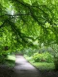 |
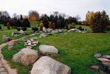
Established: 1931. The arboretum was set up at the suggestion of Latvia’s distinguished author Anna Brigadere. After her death and until 1935, the arboretum was supported and expanded by book publisher Jānis Rapa. There are some 180 foreign trees and shrubs of various kinds here. Some of the plants are outside the arboretum itself.
Unique plants: The Bunge’s Ash (Fraxinus chinensis), the Eastern Black Walnut (Juglans nigra), the American Buckeye (Aesculus glabra), the Smoketree (Cotinus coggyria), the White Mulberry (Morus Alba), and the Kentucky Yellowwood (Cladrastis kentukea).
|
|
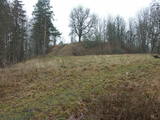 |
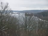
The Buse (Matkule) castle hill is near the Imula River. From the castle hill and from the opposite shore of the river, you can find one of the loveliest views of Kurzeme’s small rivers. Their appearance is best when trees and other flora are bare and the view is unimpeded. A wonderful view of the Imula valley is also seen on the road to the castle hill – near the Buse homestead.
|
|
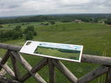 |
This park is in a region of hillocks in the Karula highlands, and Lake Ähijärve is at its centre. The park offers a cultural environment of small farms, and it was set up to protect the unique cupola-shaped hillocks of the area. Main attractions: Scenic Lake Ähijärv (176ha), Rebasemõisa Tornimägi hill (137.8 m above sea level), undulating landscapes. |
|
 |
The park was established to protect the Venta River valley and the landscapes that are around its tributaries. On the west bank of the Venta, at Papilė, there is a cliff from the Jurassic period which is unique in the Baltic States, has been known since 1925, and has layers in which more than 300 forms of life have been identified over the course of time.
|
|
 |
The territory is established in order to protect the dunes and the seashore habitats. There are beautiful beaches and wooded dunes, and the paved Klaipēda–Palanga bikeway trails through the park, which is worth travelling at full length. |
|
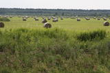 |
Open landscape area within farming lands on both banks of Uzava River about 10 km before it flows into the Baltic Sea. There is a good open view over the area from the Vendzava-Ziri road going through the nature park. Protection of migratory birds and corncrakes has been one of the main reasons for establishment of the nature park. Bird watching is possible from the road Vendzava-Ziri during migration period in spring and fall. There is no tourist infrastructure in the nature park.
|
|
 |
The terrain in this territory was created during the Ice Age. There are the ancient river valleys of the Minija, Salantas and Erla rivers, along with groups of rocks.
|
|
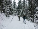 |
The nature park near the town of Ogre is a popular place for leisure, hiking and, in the winter, cross-country skiing. Most of the park is covered with coniferous trees that are on a long and comparatively narrow line of hillocks with steep sides – another element of nature left behind in Latvia by the Ice Age. Many different plants can be found here. The Jaunogres castle hill is one of the most distinct hillocks in the area. |
|
 |
At the Aizkraukle Lutheran church along the upper part of the shores of the ancient Daugava River valley, there is a bit of an old road from which one of the most beautiful views of the central section of the river can be seen, particularly when the trees are bare. Approximately one kilometre to the North-west is the Aizkraukle castle hill, which offers a no less impressive view.
|
|
 |
The nature park in the Daugava River valley is the only place between the cascades of the Daugava hydroelectric power plants there is still a chance to see the Daugava River valley and the ravines of its tributaries as they appeared before the area was flooded so that the power plants could be constructed. Particularly lovely views are found on the right bank of the river near the Aizkraukle church and castle hill. Forests, meadows, origins of streams and small dolomite cliffs in this area are all protected biotopes. Leisure facilities have been installed on the Aizkraukle castle hill, and the Aizkraukle castle ruins are not far away. |
|
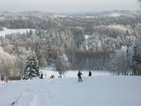 |
Gaiziņkalns Hill is the highest hill in Latvia, and it is a typical example of the hillocks of the Vidzeme highlands. This is a place of wonderful landscapes, even though there are not all that many good viewing areas. At the centre of this park is Gaiziņkalns Hill itself – the highest place in Latvia and the second highest in the Baltic States (311.6 metres above sea level). The viewing tower, alas is not open to the public, because it is in dangerous condition. There is a well-appointed hiking trail around Gaiziņkalns Hill, and during the winter the hill and its surroundings are popular for downhill and cross-country skiing. Lake Viešūrs (Lake Kaķītis) is popular among licensed fishermen. This territory is part of a region of protected landscapes around Vestiena. |
|
 |
The mouth of the most beautiful river of Vidzeme. On the seashore between the mouths of River Gauja and River Daugava, one of the largest dune ranges in Latvia with distinctive parabolic dunes overgrown with forest (wooded dunes) is situated. The Mouth of River Gauja is unique as it is one of the few major rivers in Latvia and in EU countries to flow into the sea naturally. There is no harbour or other hydro-engineering construction. It is a popular recreation area in the vicinity of Riga and Saulkrasti while, unfortunately, the lack of infrastructure makes it suffer from anthropogenic load. Not far from the rivermouth, hidden in dunes, there are pillboxes which were built in 1920 or 30ies as anti-airborne barriers. There was a whole range of them along the coastline from the mouth of the River Lielupe to the mouth of the River Gauja forming a part of the Daugavgrīva Fortress fortifications. The pillbox is made of concrete, ca 1.5m thick. Every year, on the 3rd Sunday in August, a lamprey festival takes place in Carnikava town by the Gauja rivermouth. Carnikava is called the Lamprey Capital as it is famous for its lamprey fishing tradition and generous catches. The Mouth of the River Gauja is a good bird-watching area, especially in spring and autumn when one can observe the highest variety of species. Just few of the many bird species that can be observed near the Gauja rivermouth |
|
 |
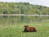
The key treasure in this park is that it has a lake that is one of the most intensive sites for birdwatchers in all of Latvia. It also features outstanding flora and the shallow waters of the Bay of Rīga. Recommended: Hike along the seashore from Mērsrags to Engure (20 km). See wild domestic animals (horses and cows) on the eastern shore of Lake Engure. There’s a bird-watching tower on the NW shore of the lake (approach from Kūļciems, where you can see domestic animals adapted to life in the wild, including the Blue Cows of Latvia). A bird-watching tower can be found at a place called Jomiņa near Mērsrags, where the seashore meadow is an uncommon biotope
|
|
 |
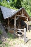
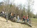
The nature trail was built in 2003 supported by the WWF, the Latvian Environment Protection Fund, the International volunteering organization supporting conservation initiatives in the United Kingdom (BTCV) involving volunteers from Nīca and Rucava municipal parishes. The trail exposes the surrounding landscapes and related biotopes – dunes, forest, grasslands and bog, as well as bird and animal species found there. On the trail, there is a bird watching tower and two birdwatcher hides. You can see the rivers Paurupe and Līgupe, beaver activity areas, grasslands, black alder forest, spruce forest, floodland, wild horses, aurochs, the Šķilu lime tree, the Holy Grove, the Ezerskolas sacrificial stone, the Pape ornithological field station, the Papes polder grasslands and the Pape lighthouse. There are resting places en route. The trail leads through the historical Ķoņu village with the traditional coastal fishing village architecture of buildings and yards. The trail is 9 km (5 km one way by a gravel road, returning 4km along the coastline). The trail is in the Pape nature park
|
|
 |
The Nemuna River divides up into two large streams at its estuary at Kuršių Marios, and this has established the Rusnė Island. This is a unique environmental territory with wetlands, streams, ancient rivers, lagoon lakes and flood plains which are important places for birds to nest and rest during migration season. Vast tracts of this territory are flooded each spring. The park includes the territory to the N and W of Rusne (lagoons, swamps, fishing ponds, Kuršių Marios).
|
|
 |
The Bauska Nature Park runs for several dozen kilometres along the Lielupe River and its tributaries – the Mūsa and the Mēmele. This is a protected territory. The shores of these rivers contain some of the largest dolomite cliffs in Zemgale. These are protected both as biotopes and as geological monuments. The rivers are important places for river lampreys and vimbas to spawn. Tourists will be attracted by the cultural landscape of the area, as well as the cultural monuments such as the Bauska castle, the Jumpravmuiža park, the Mežotne castle hill, Vīna Hill, the Mežotne castle, etc. The rivers are used for water tourism. |
|
 |
The viewing tower is in a seaside meadow near Mērsrags. It is an unusual type of biotope in Latvia and is located to the North of the Mērsrags port. The tower offers a good view of reed-filled meadows, areas where wild cattle have grazed, and an amazing wealth of different kinds of plants. |
|
 |
Ar mežiem, purviem un ezeriem (Riču, Sila u.c.) bagāta teritorija Latvijas - Baltkrievijas pierobežā. Galvenās aizsargājamās dabas vērtības - dažāda veida purvu, mežu un ezeru biotopi un tajos mītošās augu un dzīvnieku sugas. Ezeru krastos, kurus iecienījuši vietējie atpūtnieki, atrodas vairākas naktsmītnes. Ilgas muiža (celta 19. gs. kā medību pils) ir Daugavpils Universitātes studentu prakses vieta. Silenes dabas parkā ietilpst arī Glušonkas purva un Ilgas dabas liegumi.
|
|
 |
This path is found on the right bank of the ancient Abava river valley. The visitor will be able to view places where underground streams create wetlands, various kinds of meadows, a stand of juniper bushes, etc. The area is “managed” all year long by “wild” cows. The shore of the ancient valley can be climbed (some 200 steps), and the view is magnificent. It is recommended that the trail be visited in the company of a knowledgeable guide. There is a shorter path that is 600m long, along with a longer one that is more than a kilometre in length. It will take an hour or so to traverse it. Objects are found in the ancient Abava valley nature park.
|
|


