
| Нo | Название | Описание |
|---|---|---|
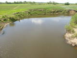 |
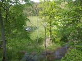
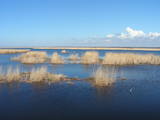
The Dviete Wetlands Nature Park contains a unique natural territory – the ancient Dviete River valley with the Lake Skuķi and the Lake Dviete and the surrounding wetland meadows. During flooding season, these wetlands store up waters from the Daugava River. They absorb a lot of floodwater at first and then slowly return it, thus reducing the level of floods in the Daugava River valley. This process is the reason for the unique ecosystem which exists in this area. It is an important location for plants and birds both during migration and nesting season. The river valley is important for birds during migration and nesting. In 2006, wild cows were released into the meadows. There is also work to improve the tourist infrastructure in the area. |
|
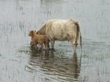 |
The shallow and mostly overgrown (65% of its surface) Lake Engure is one of those Latvian lakes which are most favoured by birds. It is a location which is governed by the Ramsar Convention on Wetlands, and 186 species of nesting birds have been identified there. The area is also distinguished by great botanical diversity (more than 800 kinds of plants). The coastline varies between sandy beaches and seashore meadows. There are forests, fishing villages and damp areas which ensure a great diversity in landscapes and species. The flood-land plains of the lake and the sea are grazing grounds for wild livestock – horses, blue cows, etc. Several bird-watching towers are open to visitors, as is the Orchid trail. The Centre for Ornithological Research is located on the eastern bank of Lake Engure. A unique floating house built by ornithologists is located on the lake. The territory is appropriate not just for holiday-makers, but also for hikers, bicyclists and bird-watchers. A leisure area and a small exhibition are located close to the ornithological research centre. |
|
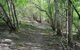 |
4 km garā un marķētā taka iepazīstina ar dziļo Imulas ieleju – Abavas kreisā krasta pieteku. Īpaši iespaidīga ieleja izskatās bezlapu periodā, kad ir apjaušami tās izmēri un formas. Vēstures cienītāji var upes gultnē uzmeklēt Langsēdes Velna pēdas akmeni. Atrodas dabas parkā „Abavas senleja”. |
|
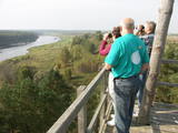 |
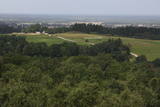
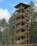
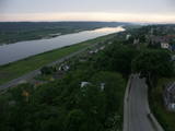
Старая деревянная башня была снесена, и на ее месте сейчас построена новая вышка. С построенной в 2015 году вышки открывается один из самых красивых природных видов Латвии, который в свое время был изображен на 10-латовой банкноте. Вид на эту излучину Даугавы считается самым красивым на протяжении всего течения реки. |
|
 |
The viewing area is near the top of the Vilce castle hill, with a view of the Rukūze River valley, Zaķi meadow, and surrounding forests. This is an unusual landscape for the region of Zemgale. The Vilce baronial estate is nearby.
|
|
 |
The mouth of the most beautiful river of Vidzeme. On the seashore between the mouths of River Gauja and River Daugava, one of the largest dune ranges in Latvia with distinctive parabolic dunes overgrown with forest (wooded dunes) is situated. The Mouth of River Gauja is unique as it is one of the few major rivers in Latvia and in EU countries to flow into the sea naturally. There is no harbour or other hydro-engineering construction. It is a popular recreation area in the vicinity of Riga and Saulkrasti while, unfortunately, the lack of infrastructure makes it suffer from anthropogenic load. Not far from the rivermouth, hidden in dunes, there are pillboxes which were built in 1920 or 30ies as anti-airborne barriers. There was a whole range of them along the coastline from the mouth of the River Lielupe to the mouth of the River Gauja forming a part of the Daugavgrīva Fortress fortifications. The pillbox is made of concrete, ca 1.5m thick. Every year, on the 3rd Sunday in August, a lamprey festival takes place in Carnikava town by the Gauja rivermouth. Carnikava is called the Lamprey Capital as it is famous for its lamprey fishing tradition and generous catches. The Mouth of the River Gauja is a good bird-watching area, especially in spring and autumn when one can observe the highest variety of species. Just few of the many bird species that can be observed near the Gauja rivermouth |
|
 |
The wooden tower was built and stands 28 metres high. It is at the top of the highest hillock of the Northern Courlandian Highlands – Kamparkalns Hill (175 metres above sea level). The tower offers one of the loveliest views in the region of the hillocks of Talsi. On a clear day, you can see all the way to the Bay of Rīga and Talsi. |
|
 |
This territory is rich with forestland and lakes (some 285 in all). There are extensive opportunities for active recreation or calm leisure.
|
|
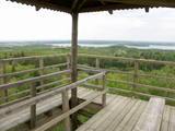 |
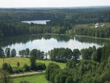
The Svene Nature Park is in the central part of the Augšzeme highlands, and Lake Svente is at its centre. This is one of the cleanest lakes in Latvia. There is also Egļukalns Hill, which offers one of the most beautiful views in all of Zemgale from its viewing tower. Visitors can gaze at the hillocks and lakes of the Svente area. Egļukalns Hill also has ski trails and a nature trail. |
|
 |
This is a shallow lagoon-type lake which, along with the area around it, is a wetland of international importance. The presence of 271 species of birds has been found in the area, including 43 birds which are listed in the Latvian Red Book and 15 that are listed in the European Red Book. The nature park includes the Nida swamp and the part of the sea which is alongside the park - newly estabilshed sea protected area "Nida - Pērkone". Between Lake Pape and the Baltic Sea we find Latvia’s oldest bird ringing station, where rings are attached not only to birds, but also to bats. Lake Pape is the first territory in Latvia where livestock adapted to life in the wild have been released for the proper management of the lake’s flood-land meadows. First there were wild horses (“Konik” horses), then aurochs and the European bison. Visitors can use bird and nature observation towers, nature trails, etc. The Ķoņi village is a unique example of a seaside fishing village. Pape is popular among bird-watchers, and the park’s visitors centre is found in the “Nature House” of the Worldwide Fund for Nature. |
|
 |
Atrodas Numerenes dabas parka teritorijā. 20 m augstais tornis uzbūvēts uz t.s. Numerenes vaļņa, no kura paveras plaša ainava un aizaugošām lauksaimniecības zemēm un nelielu mitrāju ar Kugreņa ezeru austrumu virzienā. Torņa apkaimē izveidota izziņas taka. |
|
 |
An important complex of the coastline and its sand dunes along with the mouths of three major rivers – the Lielupe, the Daugava and the Gauja. This area has ancient traditions of recreation and spa services. The territory has lovely shoreline landscapes and features one of the few coastline meadows in Latvia. The nature park includes several restricted areas – the meadows of the Lielupe estuary, Vakarbuļļi, Daugavgrīva, Vecdaugava and Ummis (see the section on “Restricted Natural Areas”). Interesting elements of nature in this area include the amphitheatre of the Garciems dunes, along with individual dunes such as the Legzdiņi dune and the so-called ski mountain dune. Visitors will be attracted by various cultural and historical monuments – fortifications on the Mangaļi peninsula, military buildings from the period of the Russian tsars all the way through the late period of the Soviet occupation, the fortress of Daugavgrīva, the Vecāķi spa with its old shoreline buildings, and the beaches at Daugavgrīva and Vecāķi. The proximity of the city of Rīga and various important recreational resources are the reason for the massive anthropogenic burden that is placed on this territory. The nature park is appropriate for active tourism (hiking, bicycling, boating, driving), distance skiing, nature and bird-watching, cultural tourism, passive leisure and educational tourism. There are nature trails at Daugavgrīva and the Rožu dunes, along with other elements of infrastructure. |
|
 |
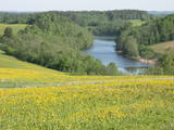
There are three large lakes at the centre of this park – Lake Dusia, Lake Metelys, and Lake Obelija. Lake Dusia has very clear and transparent water, and its southern and south-eastern beaches are popular among swimmers. The lakes and their nearby wetlands are important during the migration season of birds.
|
|
 |
This nature park features the most beautiful and distinct parts of the Vanema hillocks in Northern Kurzeme, and the aim is to protect the hillocks of Talsi. This is one of the loveliest parts of Kurzeme, with small but distinct hillocks and ravines among them. There are small but fairly deep lakes in the area – the Lake Ābeļi, Lake Čumals, Lake Sirdsezers, etc. Some of them are reminiscent of nothing other than deep craters. The territory is very good for active tourists – hikers (there are nature trails), bicyclists, etc. |
|
 |
The tower is on the banks of the little Tērvete River, with a view of the river valley and surrounding forests. Good views of the Tērvete River valley are also available from the nearby Zviedru Hill and the Tērvete castle hill. Note: The viewing tower at the Tērvete Ancient History Museum is not open to visitors!
|
|
 |
Тропа создана на склоне основного берега древней долины реки Абава, где можно осмотреть рассредоточенное выклинивание подземных вод, различные типы лугов, можжевельниковые поляны и др. На береговом склоне весь год „хозяйничают” дикие коровы. 200 ступеней приведут вас к вершине берега древней долины, с которой открывается великолепный вид. Тропу рекомендуется посещать в сопровождении местного гида. |
|
 |
The Bauska Nature Park runs for several dozen kilometres along the Lielupe River and its tributaries – the Mūsa and the Mēmele. This is a protected territory. The shores of these rivers contain some of the largest dolomite cliffs in Zemgale. These are protected both as biotopes and as geological monuments. The rivers are important places for river lampreys and vimbas to spawn. Tourists will be attracted by the cultural landscape of the area, as well as the cultural monuments such as the Bauska castle, the Jumpravmuiža park, the Mežotne castle hill, Vīna Hill, the Mežotne castle, etc. The rivers are used for water tourism. |
|
 |
This park covers the Nemuna River valley between the villages of Seredžius and Geldaudišķis, with lovely views of castle hills, medieval castles, aristocratic estates, etc., along the shores.
|
|
 |
Dabas parks, kura lielāko daļu aizņem neprastās formas un līčiem bagātais Cārmaņa (arī Cārmins) ezers. Ezera ūdens ir ļoti tīrs, tādēļ tajā sastopamas Latvijai retas augu sabiedrības. Tā kā parka teritorijā nav tūristiem veidota infrastruktūra, interesenti var baudīt skatus, kas paveras uz ezera un tā apkārtni no Aulejas – Grāveru ceļa.
|
|
 |
This nature park is located in the most distinct part of the Dagda hillocks of the Latgale highlands. Part of it is the deepest lake in the Baltic States -- Lake Drīdzis, which is 63.1 metres deep and has nine islands. Also there is Lake Otis. The loveliest views can be watched from the ancient Lettigalian castle hill that is known as Sauleskalns, and from the eastern shores of Lake Drīdzis. Accommodations are available near the lake. |
|


