
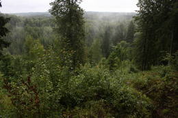
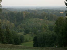
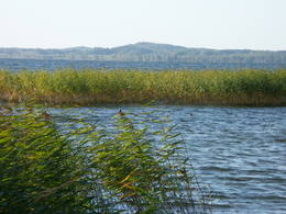
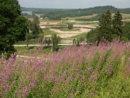
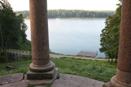
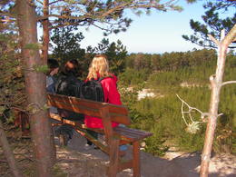
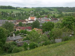
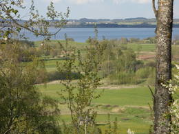
Великолепные виды на природе
Живописные участки дорог, виды на холмы, курганы, речные долины или морское побережье.
| Обзор | Подробности |
|---|---|
 |
Латвия
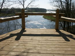
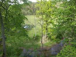
A viewing area at the White duneAt the estuary of the Inčupe River, there is the White Dune, which is around 18 metres high and is the most lovely element of the Vidzeme shoreline among those that have been created by the wind, sand and sea. There is a wooden footpath (the Saulriets trail) which is meant to view, but also protect the dune. It has a viewing area, too. The territory to the south of the river is in the Piejūra Nature Park.
|
 |
Латвия
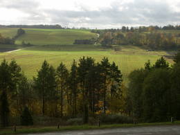
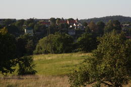
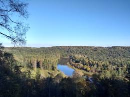
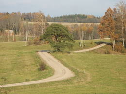
A viewing area on Greili HillAs you travel from Kandava to Sabile, you will find a parking lot on the right side of the road. From there, there are steps to a viewing area on the highest hill in the Abava Ancient River Valley – Greiļi Hill. This offers a wonderful view of the ancient river valley and the local mosaic of meadows and forests. The landscape is enriched by the Imula and Amula valleys that are on the other side of the ancient river valley.

 1-12 1-12
Услуги
1-12 Месяцы активного сезона |
 |
Латвия
Zilaiskalns HillThis is an area that is full of legend and tale. There is a stiff hillock, which stands about 66 metres above the surrounding land. From its southern side, you can see the Burtnieki lowlands. The tower, however, is not open to the public.

 107
1-12 107
1-12
Услуги
107km - Расстояние от столицы
1-12 Месяцы активного сезона |
 |
Латвия
Other viewing areas in and around SabileBeautiful views are accessible from the Sabile castle hill (steps, a location for relaxation), Upurkalns Hill (no improvements) and Briņķpedvāle, which part of the Pedvāle Open-Air Art Museum. There are also the Drubaži nature trails. The road between Kandava and Sabile which runs along the right bank of the Abava and the Aizdzire-Kalnmuiža road which runs on the left bank of the Abava also offer beautiful landscapes.
1-12
Услуги
1-12 Месяцы активного сезона |
 |
Латвия
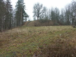
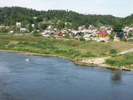
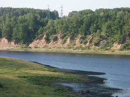
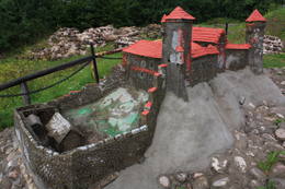
Городище БусеГородище Бусе (Маткулес) находится в изгибе берегов реки Имула. С него, на противоположный берег Имулы открывается один из самых живописных видов на речушки Курземе. Видом лучше всего любоваться в безлистный период, когда ландшафт не закрывает береговая растительность. С правого берега великолепный вид на долину Имулы открывается также по дороге к городищу рядом с домом Бусе.
1-12
Услуги
1-12 Месяцы активного сезона |
 |
Латвия
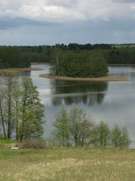
A lovely road along Lake RaznaThe eastern, southern and western shores of Lake Rāzna have roads which offer many lovely and unusual views of Latvia’s second largest lake and its surrounding landscape. Particularly lovely is the road between Foļvarkova and Vilkakrogs, which is part of the Rēzekne-Ezernieki road.
1-12
Услуги
1-12 Месяцы активного сезона |
 |
Латвия
A viewing area at the Lubane castle hillIn Dagda, on the side of Daugavpils Street, there is a forested hillock that is the Lubāne castle hill. On the upper part of its southern side, there’s a viewing area which offers a view of the small Lake Lubenenis, the eastern part of Dagda, and the white tower of the local Catholic church. Legend has it that treasure is buried here.
269
1-12
Услуги
269km - Расстояние от столицы
1-12 Месяцы активного сезона |
 |
Латвия
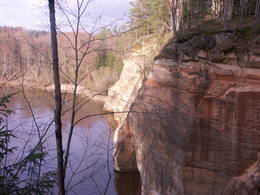
A viewing area at the Lustuzis cliffIn the centre of Līgatne, on the right bank on the rapid Līgatne River, there is a viewing plan which offers a close-up look at one of the most impressive sandstone cliffs which rise above it – the Lustūzis cliff. There are artificial caves in the wall of the cliff, which locals use as cellars and as places to store their property.
1-12
Услуги
1-12 Месяцы активного сезона |
 |
Латвия
Городище АсотеB образовании использовалась форма естественного рельефа - часть берега долины Даугавы, пересекающий Дарзупите. Согласно результатам проведенных в середине ХХ столетия археологических раскопок можно утверждать, что городище было населено с 1-го тысячелетия до н.э.до XIII века. В XI веке защитная система городища была улучшена и дополнена кольцевидным защитным валом. В это время городище Асоте стало важным краевым центром ремесленничества и торговли латгальских племен. Площадка городища возвышалась над ближайшими окрестностями на 10 м, и поэтому отсюда открывается хороший вид (в южном направлении) на остров Абелю (Яблочный), в конце северной части которого видно небольшое возвышение рельефа - городище Каупре. С другой стороны (на севере) городища Асоте находится так называемая Церковная горка – старинное культовое место. 137
1-12
Услуги
137km - Расстояние от столицы
1-12 Месяцы активного сезона |
 |
Латвия
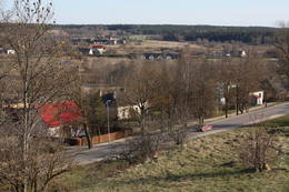
Views of EmbuteThe hill is the highest point on the shores of the little Slocene River valley, and it is located in Tukums, at the side of Jelgavas Street. It opens up a broad view of the Slocene River valley and the town of Tukums with its historical centre on the opposite side of the valley. The view is particularly interesting in the evening, when the town is lit up. There is a monument to the liberators of Tukums.
1-12
Услуги
1-12 Месяцы активного сезона |
 |
Латвия
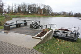
Grobinas promenade „Senais juras krasts”Gar Grobiņas ūdenskrātuvi (Ālandes labais krasts) izveidota mūsdienīga un labiekārtota pastaigu un atpūtas vieta - promenāde, uz kuras izvietotas plāksnes ar Zentas Mauriņas un Jāņa Raiņa citātiem. No promenādes paveras labi skatu punkti uz Skābaržkalnu un Grobiņas pilsdrupām. Grobiņas ūdenskrātuves sašaurinājumā pāri Ālandei ved neliels tiltiņš, kas ir bijušā Liepājas – Aizputes šaursliežu dzelzceļa tilta ferma. 206
Услуги
206km - Расстояние от столицы |
 |
Латвия
Viewing areas in KandavaWe recommend that you walk through the town of Kandava not only to enjoy the charm of a small town, but also to find fantastic viewing locations where you can see the town and the shores of the ancient Abava River valley from the Kurši (Ancestor) castle hill, Lielā Street, the Bruņinieki castle hill and Zīļu Street (School Hill), as well as from the area of the Ozolāji open-air stage.
95
1-12
Услуги
95km - Расстояние от столицы
1-12 Месяцы активного сезона |
 |
Латвия
Views of the Daugava River valleyAt the Aizkraukle Lutheran church along the upper part of the shores of the ancient Daugava River valley, there is a bit of an old road from which one of the most beautiful views of the central section of the river can be seen, particularly when the trees are bare. Approximately one kilometre to the North-west is the Aizkraukle castle hill, which offers a no less impressive view.
1-12
Услуги
1-12 Месяцы активного сезона |
 |
Латвия
A viewing location at KrievkalniAt the highest point of Krievkalni (149 metres above sea level), there is a good location for relaxation which offers an impressive view toward the East.
1-12
Услуги
1-12 Месяцы активного сезона |
 |
Латвия
Delinkalns HillFrom the highest point in the Alūksne highlands, you will see an unusually beautiful view of the surrounding forested hillocks and the small areas of meadows and farmland. Sadly, there are no improvements to the location, which can be difficult to access. It is on private property.
 1-12
1-12
Услуги
1-12 Месяцы активного сезона |
 |
Латвия
Folvarkova-VilkakrogsA beautiful part of the Rēzekne-Dagda-Krāslava road – along two km or so, you can see Lake Rāzna and Mākoņkalns hill, which is 10 km away on the other shore of the lake. 270
Услуги
270km - Расстояние от столицы |
 |
Латвия
Gaizinkalns HillLatvia’s highest hill is the second highest in the Baltic States, but alas, it has only a wrecked viewing tower, so you’ll have to look for the best views on your own. You’ll find some around the tower and the ski trails, particularly Large and Small Golgotha. It is worth hiking the Gaiziņkalns nature trail.
1-12
Услуги
1-12 Месяцы активного сезона |
 |
Латвия
Viewing areas in AluksneThese are beautiful and impressive views, particularly early in the morning, of the historical locations of Alūksne. Go to Templis Hill, the Aleksandrs Pavilion, the obelisk which commemorates Heinrich von Fittinghoff, and the memorial to soldiers of the No. 7 Sigulda Brigade for good views. The Templis Hill, the castle ruins, the estate and the pavilions are arhitectural monuments.
200
1-12
Услуги
200km - Расстояние от столицы
1-12 Месяцы активного сезона |
 |
Латвия
A landscape of hillocks and valleysThe Kurzeme Peninsula has the largest landscape of hillocks and valleys in Europe in the shoreline segment from Melnsils and Kolka to Oviši and Liepene. It is a unique landscape in Latvia, and part of it is in the Slītere National Park. The Pēterezers Nature Trail offers the best chance to look at the landscape. There are hillocks and valleys elsewhere, too – near shoreline villages where the Kukšupe valley (one of the longest ones – 8 km in all) is crossed by the Ventspils-Kolka highway, as well as near Apakšceļš. The only thing is that you need to learn how to spot the areas out in nature. 178
Услуги
178km - Расстояние от столицы |
 |
Латвия
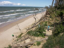
The Pusenu HillOne of the highest dunes in Latvia, located between Bernāti and Jūrmalciems villages. It is 37m high and offers a magnificent view of the sea and natural pine forests. The highest dunes in Latvia stand to the South of Jūrmalciems village: the Pūsēnu hill, the Ķupu hill, the Mietragkalns or Tiesas hill, the Pāļu hill, the Garais hill, the Ātrais hill, the Lāvas hill. The Pūsēnu dune is the highest of these dunes which are all called hills by the local people. The Pūsēnu hill developed between 1785 to 1835 when shifting sand became extremely dangerous. Several homesteads were buried in sand, among them „Pūsēni”, where a forester’s family lived. The family is said to have moved to Bārta. The dune was named after the buried homestead. Jēkabs Janševskis, a Latvian writer, wrote in his book „Nīca”: “In olden times, large pine trees were growing in the dunes on the coast of Nīca and they stood steady and firm. But i Swedish times (around 1650), the Swedes built a large kiln for charcoal and tar. Pine wood and stumps provided an excellent material for this. Once a big fire rose, and the charcoal kiln burned down as well as the whole pine forest. The remaining stumps and bare trunks in the vast burnout could not hold the storm-driven sand; it flew further and further burying not only the burned-out forest, but also the nearest fields. In wintertime, when the vast, low marshy grasslands were covered with ice, jets of sand drifted further over its surface, and soon most of the grasslands and large meadows turned into sandy heath-land and dunes.” To reconstruct Liepāja, severely damaged during WWII, a silicate brick factory was built in the town. The main raw material was white sand and it was taken from the Bernātu forest. In the 1960-ies they started to dig off the Green Dune and the White Dune, later also the Pūsēnu hill. The excavators used to work day and night, in three shifts. The work stopped at around 1980, as there was no more sand suitable for production of brick. A trail is set up to facilitate walking in the Pūsēnu Dune in the Bernātu Nature Park.
232
1-12
Услуги
232km - Расстояние от столицы
1-12 Месяцы активного сезона |
 |
Латвия
Винная гора в СабилеИзвестное еще со времен Курземского герцогства как самое северное место, где выращивали и делали кисловатое вино герцогства. С 1999 г. ежегодно, во второй половине июля, в Сабиле проходит Праздник вина. С Винной горы приоткрывается прекрасный вид на провинциальный город, который расположился на берегах древней долины Абавы.
109
1-12
Услуги
109km - Расстояние от столицы
1-12 Месяцы активного сезона |
 |
Латвия
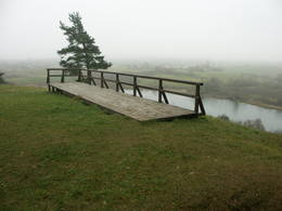
Keizarskats and KeizarkreslsOn the left bank of the Gauja River, opposite the Piķene cliff is the mighty Beite cliff which is split by a deep ravine. On the left side there is Ķeizarskats (Emperor's View), which is approximately 67 metres above the level of the Gauja and offers a fine view of Krimulda and the Turaida Castle. The viewing place was installed in 1862, when Russian Tsar Alexander II visited Sigulda. On the right side of the ravine is the mighty wooden Ķeizarkrēsls (Emperor's Chair). To get there, you have to cross the ravine (there are wooden stairs and a forest trail). You can go around it on Laurenču, Kalna and Gulbju streets. 60
Услуги
60km - Расстояние от столицы |
 |
Латвия
Viewing areas in KraslavaAn all-encompassing view of the urban environment next to the Daugava River valley is offered at the car park which is at the start of Augusta Street on the boundary of Krāslava. The unique wooden buildings of the area (the Kaplava Street region) can also be seen on the bridge which crosses the Daugava. Climb Karņickis Hill and hike through the park of the Plāters family of nobles. From there, you will see more local scenes.
1-12
Услуги
1-12 Месяцы активного сезона |
 |
Латвия
ZINATNU AKADEMIJAS SKATU LAUKUMSViena no augstākajām Latvijas celtnēm ar vienu no augstākajiem skatu laukumiem (65 m). Paveras izcila Vecrīgas un Rīgas ainava, kā arī Daugavas (līdz Rīgas HES dambim) un Pārdaugavas skati. Labi redzami blakus esošie Rīgas centrāltirgus paviljoni. |
 |
Латвия
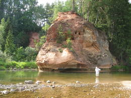
The Ergli cliffsThe viewing area on the Ērgļi (Ērģeles) cliffs offers an impressive view of Latvia’s most monolith sandstone cliffs (up to 22 metres high) – this is the highest location in the Gauja River valley. Please be very careful and don’t go anywhere near the edge of the cliff!
1-12
Услуги
1-12 Месяцы активного сезона |
 |
Латвия
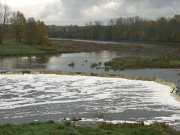
A view of the Venta fallsThe recently renovated old brick bridge and the viewing area that is on the left bank of the Venta beyond the castle guard’s hut offers a lovely view of the widest and most impressive waterfall in Latvia – the Venta falls. It is worth visiting during the spring floods, when fish are migrating.
153
1-12
Услуги
153km - Расстояние от столицы
1-12 Месяцы активного сезона |
 |
Латвия
The views of AraisiThe loveliest views of the local cultural and historical treasures (the Āraiši lake castle, the Lutheran church, the parsonage, Medieval castle ruins – all of these cultural monuments). The hillocks of the area which offers this view can be found in the immediate proximity of the Āraiši windmill and the Drabeši-Āraiši road.
1-12
Услуги
1-12 Месяцы активного сезона |
 |
Латвия
Sakas moliMolu (sākotnēji – pāļu rindas ar akmeņu krāvumiem) izbūve pie Sakas ietekas jūrā tika uzsākta 1878. gadā, lai nodrošinātu ostas darbību. 1929. gadā notiek molu pārbūve, pagarinot tos ar masīviem betona blokiem. Pēdējā rekonstrukcija notika 2010. gadā, pārveidojot molus par ērtu pastaigu un makšķerēšanas vietu, no kuras var vērot arī saulrietu. 216
Услуги
216km - Расстояние от столицы |
 |
Латвия
Межотненское городищеНаходится на левом берегу Лиелупе, напротив Межотненского замка. Одно из крупнейших укрепленных городищ земгалов 9 - 13 вв., рядом с которым на площади в 13 га располагался древний город. Благоустроено. Через Лиелупе построен понтонный мост, по которому пешеходы и велосипедисты (май - октябрь) могут пройти к Межотненскому замку. Примерно в 0,5 км к югу от городища находится Винная гора, до которой ведут деревянные мостки.
66
1-12
Услуги
66km - Расстояние от столицы
1-12 Месяцы активного сезона |
 |
Латвия
The Zvarte cliffThis is one of the most beautiful and popular tourism locations in Vidzeme. The cliff is 45 metres high, and the height of the lovely open-faced portion is around 20 metres high. You can look at the wide and deep Amata River valley and its forested banks.
83
1-12
Услуги
83km - Расстояние от столицы
1-12 Месяцы активного сезона |
 |
Латвия
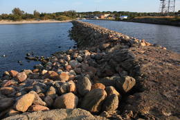
The Northern breakwater of LiepajaThe Northern breakwater of Liepāja is located n the Karosta area of the town. It offers a lovely place for perambulations, as well as an opportunity to observe the sea. To the South of the breakwater you will find a fine view of the Liepāja Freeport and its system of breakwaters. To the East is the unique Karosta area, while to the North, there are remnants of a sea fort. Please be very careful while observing the sea, however – the surface of the breakwater is not in great shape.
215
1-12
Услуги
215km - Расстояние от столицы
1-12 Месяцы активного сезона |
 |
Латвия
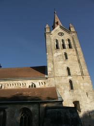
Viewing locations in CesisThe tower of St John’s Lutheran Church in Cēsis, which is one of the oldest stone buildings in Vidzeme, offers a view of the historical centre of Cēsis, and a wide area all the way to Zilaiskalns Hill. There is also the western tower of the ruins of the Cēsis castle, one of the strongest fortresses of the Livonian Order in the Baltic region, and it offers a grand view of the castle’s park.
90
1-12
Услуги
90km - Расстояние от столицы
1-12 Месяцы активного сезона |
 |
Латвия
Отвесный берег Балтийского моряНачинается в нескольких километрах к северу от Павилосты и заканчивается недалеко до Ошвалки, протяженностью > 30 км. Его внушительные и необыкновенные формы просматриваются на участке Странте - Улмале, но и открывающиеся в окрестностях Юркалне (благоустроенные места для подхода, лестницы, автостоянки) виды (высота до 16 м) оставляют незабываемое впечатление! Отвесный берег рекомендуется наблюдать (смотреть, фотографировать) после сильных бурь, потому что во второй половине лета его обнажения (главным образом, песчаник, глина) выглядят менее выразительными из-за оползней и покрывающей растительности. Предыдущее название Юркалне – Феликсберг означало Счастливая гора. Теперешнее название это место получило в 1925 году. 200
1-12
Услуги
200km - Расстояние от столицы
1-12 Месяцы активного сезона |
 |
Латвия
The Markova castle hillFrom the Markova castle hill, which you will access from the local information trial, you will see a view of the Daugavsargi curve of the Daugava. Further along, you will reach the open shore of the Daugava to see one of the most unique landscapes of Latvia’s river valleys. The Slutišķi village of Old Believers and the mighty Slutišķi cliff will be in the background.
245
1-12
Услуги
245km - Расстояние от столицы
1-12 Месяцы активного сезона |
 |
Латвия
Views of VecslabadaIn Vecslabada, there is a peninsula among Lake Dziļezers, Lake Audzeļi, and Lake Istra. From the highest point on the peninsula, you will see a truly unusual view of the land of the blue lakes – lake islands, as well as the village of Vecslabada with its church towers. The Lake Istra nature reserve is nearby.
318
1-12
Услуги
318km - Расстояние от столицы
1-12 Месяцы активного сезона |
 |
Латвия
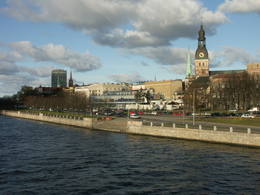
Views of Old RigaThe classical skyline of Old Rīga can be enjoyed from several locations – Mūkusalas Street, between the railroad bridge and the stone bridge, from the stone bridge, from the A-B dam, from the grounds of the central office of the Swedbank bank, from the Vanšu bridge, and from the Ballast Dam at Ķīpsala. You can hike or bike from location to location. During the summer, little ships cruise up and down the Daugava to offer different views.
1-12
Услуги
1-12 Месяцы активного сезона |
 |
Латвия
Viewing locations in TalsiThe town of Talsi is known as the “town of the nine hillocks,” and it is worth touring the location on foot. You’ll find the best views from the Talsi castle hill (views of Lake Talsi and Ķēniņkalns Hill), Sauleskalns (Lake Talsi, the castle hill, Ķēniņkalns Hill), and the hiking trails of Ķēniņkalns (Lake Talsi, the castle hill, the historical town centre).
119
1-12
Услуги
119km - Расстояние от столицы
1-12 Месяцы активного сезона |
 |
Латвия
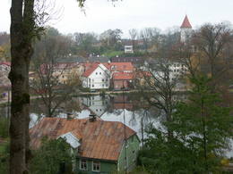
Лудзенское городищеThe Ludza castle hill offers one of the most interesting views in Latgale – that of the oldest town in Latvia and its historical centre, Great Lake Ludza and Small Lake Ludza, the ruins of the castle of the Livonian Order, Baznīckalns hill, churches, the regional research museum, the craftsmen’s centre, etc.
267
1-12
Услуги
267km - Расстояние от столицы
1-12 Месяцы активного сезона |
 |
Латвия
A viewing area on the Vilce castle hillThe viewing area is near the top of the Vilce castle hill, with a view of the Rukūze River valley, Zaķi meadow, and surrounding forests. This is an unusual landscape for the region of Zemgale. The Vilce baronial estate is nearby.
|
 |
Латвия
Daugavas aizsargdambji JekabpiliDaugavas aizsargdambju būvniecību Jēkabpilī uzsāka pēc 1981. gada lielajiem paliem, kad ūdens līmenis pārsniedza kritisko - 6,3 m atzīmi un pakāpās līdz rādījumam „8,7 metri”. Šo plūdu laikā puse pilsētas klāja Daugavas ūdeņi. 2011. gada vasarā notika plašāki dambja atjaunošanas un labiekārtošanas darbi. Pie tā uzstādīja laternas, soliņus, izveidoja pastaigu promenādi un piemiņas zīmi Daugavas kreisajā krastā, kas parāda maksimālo plūdu līmeni. Uz aizsargdambja Daugavas labajā krastā ir izvietoti informatīvie stendi, kur var uzzināt daudz interesantus faktus par pilsētas vēsturi. Dambji ir piemērota vieta, kur fotografēt vai gleznot pilsētas ainavas. 137
Услуги
137km - Расстояние от столицы |
 |
Латвия
Viewing locations in SiguldaThe impressive Gauja River valley and its best natural and cultural landscapes can be seen from Paradīze (Gleznotāji) Hill, the Sigulda castle ruins, the aerial tram, the Ferris wheel, the Ziediņi and Pilsēta ski trails, the area of the bobsled and sledding trail, Ķeizarskats, the viewing area of the Velnala cliffs, the mountain bike route of Sigulda (on the right bank of the Gauja, particularly when the trees are bare), the area of the Krimulda castle ruins, Dainu Hill, and the Turaida castle tower.
53
1-12
Услуги
53km - Расстояние от столицы
1-12 Месяцы активного сезона |
 |
Латвия
The Druskas castle hillThis is a view worth a journey from a distance. This is an impressive terrain for Latvia, and here you will see as far as the Hanja highlands of Estonia, where the Great Munameģis Hill – the highest surface in the Baltic States – can be found.
1-12
Услуги
1-12 Месяцы активного сезона |
 |
Латвия
Vina kalns MezotneAptuveni 0,5 km dienvidos no Mežotnes pilskalna atrodas Vīna kalns, kas līdzīgi kā Mežotnes pilskalns, ir veidots, izmantojot Lielupes ielejas stāvās krastu nogāzes, tās pārveidojot. Vietvārds ir it kā radies no stāsta, ka šeit parādījies dievgalds ar maizi un vīnu. Vīna kalnu ar Mežotnes pilskalnu savieno jauka koka laipa, kas ved pa Lielupes ielejas pamatkrasta lejas daļu. 74
Услуги
74km - Расстояние от столицы |
 |
Латвия
Большая Липовая гораНаивысшая точка Разнавскогохолма Латгальской возвышенности и третья по высоте вершина в Латвии (289,3 м н.у.м.). Относительная высота холма - 86 м! Платформа смотровой вышки - наивысшая точка Латвии в настоящий момент (323 м н.у.м.), на которую можно подняться пешком! Окрестности Липовой горы благоустроены. 283
1-12
Услуги
283km - Расстояние от столицы
1-12 Месяцы активного сезона |
 |
Латвия
Маконькалнс (гора Фолкенберг, Падебешу)Один из популярнейших туристическихобъектов Латгалии.С вершины возвышенности (247 м н.у.м., около 60 м над ближайшими окрестностями) приоткрывается один из красивейших видов Латгалии на находящееся в двух километрах озеро Разна. На Маконькалнсе находится построенный в XIII веке и практически неприступный замок Ливонского ордена Фолкенберг – одно из первых укреплений Латгалии, от которого до наших дней сохранились только фрагменты стен . У подножья Маконькалнса открыта памятная доска, вещающая о посещении Латгалии президентом Первой Латвийской Республики Карлисом Улманисом в 1938 году. 281
1-12
Услуги
281km - Расстояние от столицы
1-12 Месяцы активного сезона |
 |
Латвия
Elka HillElka Hill is one of the highest surfaces in the western part of the Vidzeme highlands, and it offers a lovely and broad view to the North. There is a small parking lot, a TV and radio tower, and the place where the Gauja River is thought to originate.
1-12
Услуги
1-12 Месяцы активного сезона |
 |
Латвия
The Augstroze castle hillThis is not a well known castle hill, but it offers one of the most unusual views of Lake Lielezers of Augstroze. There are ruins on the castle hill, and a short hiking trail has been installed to look at them. This is part of the ZBR.
1-12
Услуги
1-12 Месяцы активного сезона |
 |
Латвия
The Dunduri meadowsThe barrow which offers a good view is at the northern end of the Dunduri meadows – at the end of Melnragi. It is an artificial barrow which follows along with the bed of the little Slampe River. The meadows are home to livestock allowed to live in the wild, and you can see a bit of the restored Slampe. The view is particularly interesting during flooding season, when the surrounding wetlands become saturated. This is a location for bird-watching.
1-12
Услуги
1-12 Месяцы активного сезона |
 |
Латвия
The Nelkes cliffsThe Neļķes cliffs are in Skaņākalns Park, and they offer the most beautiful view of the Salaka River valley, with its sandstone cliffs and peaceful river. There are good views from the “devil’s pulpit.” It’s worth visiting the Skaņamkalns Hill to check out the views from the famous echo cliff. This is part of the ZBR.
1-12
Услуги
1-12 Месяцы активного сезона |
 |
Латвия
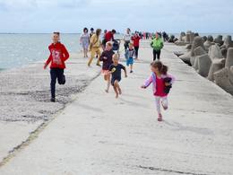
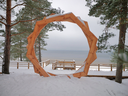
"Sunset watcher"A new section of the walking trail along the sea has been built and an environmental object "Sunset watcher" has been created in Saulkrasti near the White Dune and Sunset Trail. It is a photo object where the newlyweds and every guest of Saulkrasti can capture memories in the symbol of the sun, which is so characteristic of Saulkrasti. 
 42
1-12
42
1-12
Услуги
42km - Расстояние от столицы
1-12 Месяцы активного сезона |
 |
Латвия
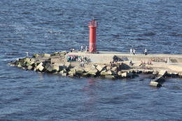
Восточный мол ДаугавыДля уменьшения засорения устья реки и регулирования течения в середине 19-го века был построен Восточный мол протяженностью 980 м. В основании мола находится деревянная свайная конструкция, закрытая камнями. Современный мол протяженностью 2,2 км был восстановлен в наше время и служит любимым местом для прогулок, отдыха и рыбалки во все времена года. С мола можно наблюдать за птицами, изредка может посчастливиться увидеть тюленя. В начале мола находятся два камня, выбитый на которых текст гласит, что строительство мола посетили российский император Александр II (в 1856-м году) и наследник престола Николай Александрович (в 1860-м году). Этот факт возвышает значение Рижского порта в контексте торговый путей Балтийского моря того времени. 1-12
Услуги
1-12 Месяцы активного сезона |
 |
Латвия
A view from the dam of the hydroelectric power plant at PlavinasIn Aizkraukle, drive down Enerģētiķu Street to the Selonian side (there will be small “pockets” at the side of the road) to see one of the best views of the Daugava River valley, reminding us of what this fateful river was like before the power plant was built. You will see that the river has eroded the steep cliffs on the right bank. The further part of the valley is part of the Daugava Nature Park.
1-12
Услуги
1-12 Месяцы активного сезона |
 |
Латвия
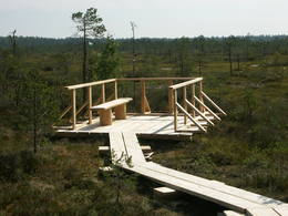
A viewing area at the Planci swampAt the end of a wooden footpath in the Planči swamp is a viewing area and place for leisure. This is the place where you can enjoy landscapes of the high-type swamp and breathe the unusual air of the swamp. This is the only outdoor infrastructure object in Latvia with information posted in Braille. It is in the ZBR.
1-12
Услуги
1-12 Месяцы активного сезона |
 |
Латвия
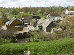
Науенское (Вецпилсское) городищеНауенское городище находилось на крутом правом берегу долины Даугавы на высоте 25 м, между двумя оврагами. Под руководством магистра Ливонского ордена Эрнеста фон Раценбурга в 1275 - 1277 гг. на месте прежнего латгальского деревянного замка возводится каменный замок. До середины XVI века замок служит резиденцией комтура Динабурга. В 1577 году войска Ивана Грозного полностью разрушили замок. После этого события Динабург теряет свое стратегическое значение, и строительство новых укреплений начинается в том месте, где сейчас находится Даугавпилс.Рядом с развалинами замка ордена установлен уменьшенный макет замка. С места автостоянки до городища можно дойти по тропе. С городища открывается один из красивейших видов на изгибы Даугавы.
235
1-12
Услуги
235km - Расстояние от столицы
1-12 Месяцы активного сезона |
 |
Латвия
The Inceni castle hillThis is one of the most lovely and expressive castle hills in Latvia, with a very fine view of territory all the way to Lithuania. According to Ernests Brastiņš, a researcher of castle hills in Latvia, this was the site of the Semigalian Sidrabene castle. There are no improvements in the area.
1-12
Услуги
1-12 Месяцы активного сезона |
 |
Латвия
Эважский отвесный берегБлагоустроенная природная тропа знакомит с одним из редких обрывов Рижского морского залива (высотой до 15 м) и лесами побережья. По лестнице можно спуститься к необыкновенно узкой полоске песчаного пляжа, который во время шторма исчезает в морских волнах. Протяженность тропы - 0,3 км в одном направлении. На обочине шоссе Колка – Юрмала обустроена автостоянка (находится у границы Слитерского национального парка). |
 |
Латвия
Bakuzi HillThe area known as the territory of high hillocks has several heights – Lakta Hill (250 metres above sea level), Egļu Hill (268 metres above sea level), and Bākūži Hill (272 metres above sea level). They are connected by an earthen road – it’s worth hiking the trail to find the best viewing areas. A very fine view of the backs of hillocks in the Vidzeme highlands can be seen from the northern side of Lakta Hill.
1-12
Услуги
1-12 Месяцы активного сезона |
 |
Латвия
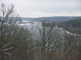
BAKANo ūdens tūrisma attīstības centra „Bāka” skatu laukuma, kas atrodas Lubāna ezera ziemeļdaļā pie V 560 autoceļa, paveras viens no labākajiem Lubānas ezera skatiem. Redzams milzīgais Latvijas lielākā ezera klajs un Kvāpānu – Īdeņas zivju dīķu ar dambjiem ainava. 219
Услуги
219km - Расстояние от столицы |


