
| Nr | Nosaukums | Apraksts |
|---|---|---|
 |
Enerģijas sēta Navesti upes krastā ir Igaunijas lielākais uzņēmums, kas nodarbojas ar ārstniecības augu audzēšanu, izmantojot dabai un cilvēka veselībai draudzīgas metodes. Apskatāmas ārstniecības augu mācību takas, moderna tējnīca, jauns semināru centrs kopā ar spa. |
|
 |
Cafe Vizbuļi atrodas Bērzciemā, Engures novadā, apmeklētājiem piedāvā nobaudīt gardu maltīti, svaigi ceptas smalkmaizītes, izbaudīt Bērzciema jūru, atpūsties un relaksēties. Ziemas sezonā kafejnīca atvērta tikai nedēļas nogalē, vasaras sezonā - katru dienu, ir āra terase. |
|
 |
Restorāns "Orizzonte" atrodas pašā jūras krastā ar divām terasēm un visaptverošu skatu uz Jūrmalu. Latviešu virtuve: Marinēta siļķe ar biezpienu, kartupeļu pankūkas, cepta Baltijas bute, jēra kumbrs, Latvijā ražoti sieri. |
|
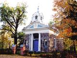 |
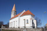
Kuļņevas (Ilzeskalna) pareizticīgo baznīcu 1832. gadā cēlis
Ilzenbergas (Ilzeskalna) muižas īpašnieks Mihails Kuļņevs, Jakova
Kuļņeva brālis. Baznīcā apskatāms grezns ikonostass ar 19. gs.
gleznām. Baznīca ir taisnstūra celtne ar pusapļa sānu izvirzījumiem
nišu veidā. Šeit apbedīti Kuļņevu ģimenes locekļi. Kapa vieta baznīcā
ir reti sastopama parādība Latvijas pareizticīgo baznīcās.
|
|
 |
Ungurmuižas parkā, kas ir slavens ar izcilajiem un resnajiem dižozoliem, kuru aprupējošie stumbri, dzīvā un mirusī koksne ir daudzu sugu, t.sk. jau Eiropā izzudušu vienīgā mājvieta, ir izveidota dižkoku taka. Garums 1,3 km, laiks līdz 1 h. Parkā atrodas Latvijā vienīgā līdz mūsdienām saglabājusies 18. gs. sākuma koka pils u.c. kulūrvēsturiskas vērtības
|
|
 |
Uz iespaidīgo Gaujas senleju, tās dabas un kultūrainavu labākie skatu punkti paveras no Paradīzes (Gleznotāju) kalna, Siguldas pilsdrupām, Gaisa trošu ceļa, Panorāmas rata, Ziediņa un Pilsētas kalnu slēpošanas trasēm, Bobsleja un kamaniņu trases apkārtnes, Ķeizarskata, Velnalas klinšu skatu laukuma, Siguldas kalnu velomaršruta (Gaujas labais krasts, īpaši bezlapu periodā), Krimuldas pilsdrupu apkārtnes, Dainu kalna un Turaidas pils torņa.
|
|
 |
Spilves pļavas tika izmantotas kara aviācijas vajadzībām jau 1. Pasaules kara laikā. 1922. gadā bumbu sabojātā lidlauka atjaunošanu veica Latvijas Republikas Aviācijas divizions Jāzepa Baško vadībā. Drīz pēc tam Spilvē 51 hektāru lielā teritorijā pie Rīgas - Bolderājas dzelzceļa atzara un šosejas iekārtoja arī civilo lidostu, kuru no Rīgas pilsētas nomāja Latvijas Pasta un telegrāfa departaments. |
|
 |
Piedāvā pirts rituālus ar sildīšanu un pēršanu ar slotām, kontrasta procedūrām, dažādām maskām un augu skrubjiem. Saimniecībā ražo un popularizē ārstniecības augu lietošanas tradīcijas. Piedāvājumā dažādas zāļu tējas. Atkarībā no gadalaika, iespējams baudīt un iegādāties dažādus augu sīrupus. Izgatavo zāļu paklājus pirtij. |
|
 |
Atrodas Neretas centrā, Rīgas ielā 2. Baznīcu (baroka stils ar vēlīnās gotikas iezīmēm) uzskata par vienu no vecākajiem Zemgales dievnamiem. To cēla laikā no 1584. - 1593. g. pēc grāfa Vilhelma fon Eferna iniciatīvas (pārbūvēts 1679. g.). Baznīcā atrodas Vilhelmam fon Efernam un Georgam fon Efernam veltīti no akmens kalti kapakmeņu ciļņi, kas darināti 16. gs. beigās (G. Eferna kapakmens – izcilākais agrīnā ziemeļu manierisma mākslas darbs Latvijā), P. Handlera darināta altārglezna (1863. g.), R. Knaufa būvētas ērģeles (1893. g.), E. Baijermana veidotas logu vitrāžas (1900. g.), 17. un 19. gs. griestu lukturi. Baznīcas apmeklētāji var apskatīt Neretas un tās apkārtnes ainavu no 38,6 m augstā savdabīgā baznīcas astoņstūru torņa.
|
|
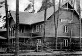 |
„Strand” komplekss bija lielākais un greznākais Neibādē. Tas sastāvēja no trim ēkām, deju paviljona un parka. Mūsdienās saglabājusies tikai viesnīcas ēka, kurā bija iekārtota Saulkrastu ambulance – Ainažu ielā Nr. 17. (Avots: Saulkrastu TIC) |
|
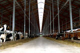 |
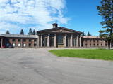
AS „Agrofirma Tērvete” ir lielākais daudznozaru lauksaimniecības uzņēmums Latvijā, kas darbojas 5 nozarēs - augkopība, piena lopkopība, zirgkopība, sabiedriskā ēdināšana, biogāzes ražošana. |
|
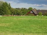 |
Zemnieku saimniecība Pumpuri reģistrēta 1994. gadā, kura īpašnieks ir Jānis Mičulis. Tās pamatnodarbošanās ir piena lopkopība. Kad piena pārstrādes nozarē situācija bija kritiska, saimniecība papildus ienākumu gūšanai 2008. gadā sāka nodarboties ar mājražošanu - ražot dažāda veida sierus gan sāļos, gan saldos. Sieri Kā top siers Apmeklētājiem Kur iegādāties sierus
|
|
 |
Atrodas aiz Grobiņas ūdenskrātuves Ālandes upes kreisajā krastā (Pīlādžu ielā 3.). Mūsdienās redzamo apmetni izveidojis tūristu klubs „Oga”, kas nākamajā tūrisma sezonā plāno šajā vietā organizēt dažādas ar vikingu dzīvi saistītas aktivitātes, kas būs nozīmīgs vēstures izziņas moments. Te varēs iejusties vikingu tēlos, doties izbraucienā ar vikingu kuģi (vikingu tērpos) pa Ālandes upi, kā arī iepazīt apkaimes vietas, kas saistītas ar vikingu tematiku. Pie apmetnes uzstādīta no koka veidota vikinga skulptūra ar ragiem (no govīm, kas ganās Vītiņu pļavās, Liepājas ezera krastā). |
|
 2 dienas
|
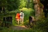
This part of the Forest Trail passes through the historical centre of Valmiera. In Valmiera you can visit St. Simon’s Church, the Ruins of the Livonian Order Castle and Valmiera Museum. We also suggest walking the barefoot trail in “Sajūtu Parks” (Park of Senses). After sightseeing in Valmiera, the Forest Trail goes through Atpūtas (Recreation) park, the beautiful pine forest and Baiļi winter ski centre. Further on you will walk along the River Abuls Trail, curving along the banks of the river until reaching the Brenguļi brewery built in an old Hydroelectric power plant. You can enjoy unfiltered and unpasteurised beer here. Further down you will enter unpopulated forest areas and the Northern Gauja protected landscape area. The forests in Northern Gauja (“Ziemeļgauja”) are very diverse. There are old or natural boreal (northern) forests and marsh forests, oak forests, alluvial forests (formed on river sediments which periodically flood) and mixed oak, wych elm and ash forests along the river. The tour will end in Strenči Town. |
|
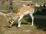 |
Saimniece novadīs ekskursiju ar Āfrikas strausu, dambriežu, Soay šķirnes aitu un eksotisko putnu un mājputnu apskati. Apmeklētājiem piedāvā saskarsmi ar dzīvniekiem un suvenīru iegādi. |
|
 |
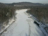
Viena no Latvijas izteiktākajām subglaciālo iegultņu sistēmām, kurā izvietojušies 11 dažāda lieluma un dziļuma ezeri. Izcili ainaviska teritorija, kurā īpaši tāli un skaisti skati līdz pat Hānjas augstienei Dienvidigaunijā paveras no Drusku – senču pilskalna. Teritorija veidota arī biotopu, piemēram, boreālo un nogāžu mežu aizsardzībai. Lai arī teritorijai piemīt ārkārtīgi liels ainaviskais un tūrisma potenciāls, tas līdz šim ir minimāli izmantots. Dabas liegums atrodas Veclaicenes aizsargājamo ainavu apvidū (sk. sadaļu "Aizsargājamo ainavu apvidi").
|
|
 2 dienas
|
Maršruts iepazīstina ar Latgales mājražotājiem, zemnieku saimniecībām, SIA u.c., kas ražo dažādus piena pārstrādes produktus – pienu, jogurtus, biezpienu, sieru, saldējumu u.c. Tā sākums ir Preiļi, ko dēvē par Latvijas sieru galvaspilsētu. Maršruts aizlokas gar Teiču rezervātu (ceļa malā – skatu tornis) un šķērso tādu Eiropas mērogā nozīmīgu teritoriju kā Lubāna mitrājs. Tālāk tas virzās uz Rēzekni (apskatāmi dievnami, Latgales Mārai veltītais piemineklis, „Gors”, „Zeimuļš” u.c.). Dabas draugi var izmest loku cauri Rāznas nacionālajam parkam, apmeklējot Rāznas ezeru, Mākoņkalnu un svēpētās keramikas meistaru – E. Vasilevski. No Dagdas tālākais virziens ir svētceļnieku centrs – Aglona un Rušona ezers. Starta punkts ir arī finiša punkts. |
|
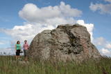 |
Perispeas pussalas piekrastē ir izvietojušies gan bijušie zvejniekciemi, gan Padomju armijas kara bāzu atliekas. Viena no pussalas savdabībām ir arī grandiozie ledāja atnestie dižakmeņi: nezinātājam ne visai viegli atrodamais un grūti pieejamais (jūrā) Odakivi, Purekari raga (Purekkari neem) galā starp citiem akmeņiem guļošais Purekari akmens (Purekkari rändrahn), jūras apskalotie Mehu akmeņi (Mähu kivid), Vīnistu (Viinistu) ciema krastmalā guļošais Melnais akmens (Must kivi), pāri niedru galotnēm savu „virsotni” izslējušais Kuhjakivi, visnotaļ iespaidīgais Painuva kivi, līdz kuram var nokļūt tikai peldus un savā ziņā nepārspējamais Jaani – Tooma suurkivi. Četri no pieminētajiem akmeņiem ir sasnieguši vai pat pārsniedz piecu metru augstumu! Akmeņiem bagāts ir Turbunēmes (Turbuneeme) ciems. Būs nepieciešams patiess entuziasms un laiks, lai visus uzskaitītos milžus atrastu un iemūžinātu savā fotokolekcijā. Perispeas pussala beidzas ar tālāko Igaunijas sauszemes ziemeļu punktu – Purekari ragu, kas ir ļoti ainaviska vieta. |
|
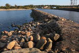 |
Molu (sākotnēji – pāļu rindas ar akmeņu krāvumiem) izbūve pie Sakas ietekas jūrā tika uzsākta 1878. gadā, lai nodrošinātu ostas darbību. 1929. gadā notiek molu pārbūve, pagarinot tos ar masīviem betona blokiem. Pēdējā rekonstrukcija notika 2010. gadā, pārveidojot molus par ērtu pastaigu un makšķerēšanas vietu, no kuras var vērot arī saulrietu. |
|
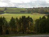 |
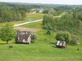
Braucot no Kandavas un Sabili, ceļa labajā pusē izveidots stāvlaukums, no kura ved kāpnes uz skatu laukumu Abavas senlejas augstākās vietas – Greiļu kalna nogāzē. No tās paveras viens no labākajiem senlejas skatiem ar pļavu un mežu mozaīku. Ainavu bagātina otrā senlejas pusē esošās Imulas un Amulas ielejas.
|
|


