
Ar kājām
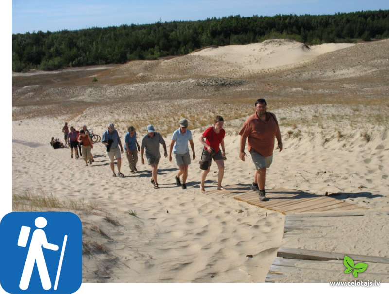
Baltijā ir izveidotas daudzas dabas, izziņas un mācību takas, kuru mērķis ir iepazīstināt ar apkārtnes "vērts redzēt" vietām. Lieliskas takas izstaigājamas nacionālo parkos un citās īpaši aizsargājamās dabas teritorijās. Ja gribas ko neredzētāku - jāņem tālskati un jādodas uz kādu putnu vērošanas vietu pavasara vai rudens migrāciju laikā. Droši, ka redzēsiet ne vienu vien retumu! Arī pārgājiens ar purva kurpēm, vai gājiens gar jūras krastu ir iespaidīgs. Ne visi ceļojumi ir pieejami latviešu valodā, tāpēc, iesakām Baltijas apceļošanas idejām skatīt arī šo lapu angļu vai vācu valodās.
- Mēs varam Jums organizēt arī mantu pārvešanu, ja veicat garāku ceļojumu – no vienas naktsmītnes uz otru.
- Pēc rezervācijas nosūtīsim Jums precīzu ceļojuma programmu ar datumiem, kā nokļūt uz naktsmītnēm un Jūsu pasūtījuma apstiprinājumu visiem Jūsu apmaksātajiem pakalpojumiem.
- Pirms ceļojuma nosūtīsim Jums arī atbilstošo ceļa aprakstu ar apskates vietām, ieteikumiem, kur paēst un kartēm. Skatiet ceļa aprakstu te (pdf file). Dažiem ceļojumu maršrutiem ir pieejamas GPS koordinātes.
- Mēs varam izstrādāt ceļojumu pēc jūsu individuāla pasūtījuma, ņemot vērā Jūsu vēlmes, fizisko sagatavotību un ceļojuma mērķi. Jūs varat pasūtīt arī tikai maršruta aprakstu, bez papildu pakalpojumiem (tā cena ir no 35,-EUR). Brauciena kopējās izmaksas atkarīgas no Jūsu izvēlētajām naktsmītnēm un citiem papildu pakalpojumiem.

Sasniedz Jūrtaku ar sabiedrisko transportu!
Pārgājienu sezona jau rit pilnā sparā, tapēc Lauku ceļotājs kopā ar reģionālajiem partneriem, un sadarbībā ar Autotransporta direkciju, aicina šajā pavasarī – Sasniedz Jūrtaku ar sabiedrisko transportu! Kopā ieteikti 15 vienas dienas un 9 divu dienu pārgājienu maršruti, kurus ērti sākt un beigt, izmantojot sabiedrisko transportu. Transporta izejas un atgriešānās punkts dots Rīgā. Vienas dienas posmu sākumpunkti ir sasniedzami ar transportu no rīta un vakarpusē ir iespēja doties atpakaļ no galamērķa, savukārt, divu dienu maršrutu sākumpunkti ir sasniedzami pirmās dienas rītā, tiek piedāvātas iespējamās naktsmītņu vietas, un otrās dienas vakarā ir ērti atgriezties. Iepazīsties ar maršrutiem šeit (spiežot uz attiecīgās dienas pieejams detalizēts posma apraksts):
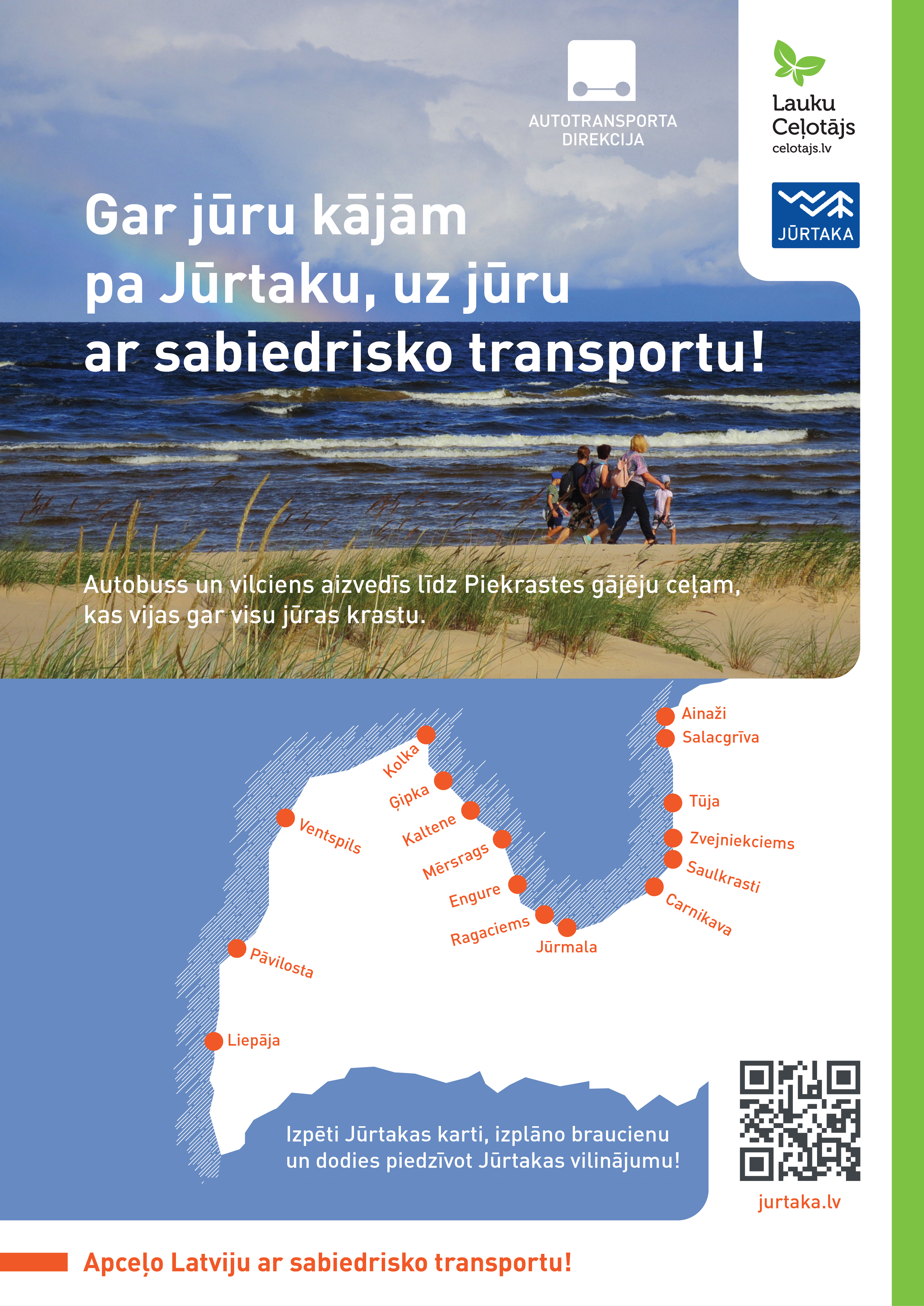
>>>Vienas dienas maršruti
>>>Divu dienu maršruti
Mājaslapa: jurtaka.lv
Jūrtakas ceļvežu lejupielāde: coastalhiking.eu/lv/c/publications
Pievienojies Jūrtakai, kur vien vēlies, atvadies, kad vēlies, un atgriezies, kad esi pēc tās noilgojies, jo Jūrtaka tevi gaida vienmēr!
Jūrtaka tapusi Igaunija-Latvijas programmas no Eiropas Reģionālā attīstības fonda projekta "Pārgājienu maršruts gar Baltijas jūras piekrasti Latvijā un Igaunijā"ietvaros.
Šis raksts atspoguļo autora viedokli. Programmas vadošā iestāde neatbild par tajā ietvertās informācijas iespējamo izmantošanu.
Maršruti kājāmgājējiem
Piedāvājam vairākus dažu stundu vai 1-2 dienu maršrutus kājāmgājējiem nacionālajos parkos un citās dabas vietās.
| Kolkasraga aplis | Latvija, Slīteres NP | 1 diena (~1-2 h) |
| Iepazīsti Mazirbi | Latvija, Slīteres NP | 1 diena (~ 4 h) |
| Ar kājām pa Lībiešu ciemiem | Latvija, Slīteres NP | 1-2 dienas |
| Gar Zaļo kāpu | Latvija, Ķemeru NP | 1 diena (~ 3-4 h) |
| No Jaunķemeriem līdz Klapkalnciemam | Latvija, Ķemeru NP | 1 diena |
| Ķemeri - vēsturiskais kūrorts | Latvija, Ķemeru NP | 1 diena (~3-4 h) |
| Gar Vidzemes akmeņaino jūrmalu | Latvija, Ziemeļvidzeme | 1 diena (~ 7h) |
| Botānikas tūre kājāmgājējiem | Latvija, Ziemeļvidzeme | 1 diena (~ 7h) |
 2 dienas
Kopējie attālumi ar kājām 27 km
|
Latvija
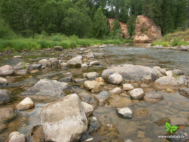
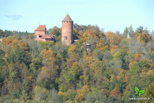
Gaujas nacionālais parks. Līgatne – Amatas senleja – CēsisPiemērots aktīviem gājējiem, kam patīk apvienot dabas vērošanu ar kultūrvides un vēstures izziņu. Šis ir ceļojums pa Baltijas iespaidīgākās upes – Gaujas senleju un tās pietekas – Amatas dziļo senleju. Abu upju krastos paceļas ainaviski devona perioda smilšakmens atsegumi. Līgatnes papīrfabrikas ciemats ir Eiropas mērogā izcils industriālā mantojuma piemērs ar savdabīgu – 19. – 20. gs. papīrfabrikas ciematvidi. Maršruta noslēgumā apskatāma Cēsu viduslaiku pils – varenākais viduslaiku Livonijas cietoksnis. Maršruta informācija no Latvijas Lauku foruma 

 5-9 5-9
Pakalpojumi
5-9 Aktīvie sezonas mēneši |
 2 dienas
Kopējie attālumi ar kājām 45 km
|
Latvija
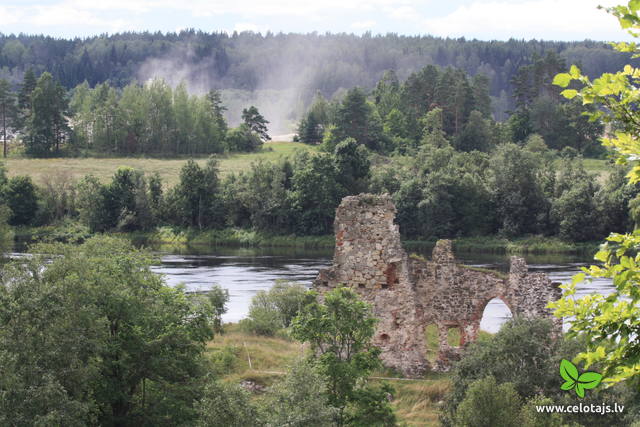
Daugavas loki. Krāslava - JuzefovaMaršruts ved pa dabas parku „Daugavas loki”, ko pagājušā gadsimta astoņdesmitajos gados gribēja appludināt, uzceļot Daugavpils HES. Dabas parka centrālā artērija ir Daugavas senieleja. Daugavas īpatnība ir astoņi lieli upes līkumi - loki, kuru garums sasniedz 4 - 6 km. Upes krasti lielāko augstumu sasniedz t.s. Daugavas vārtos, kur tos iekļauj stāvās un varenās Ververu un Slutišku kraujas. Vairāk kā ½ no teritorijas aizņem meži, kas piemēroti pārgājieniem un dabas vērošanai, ogošanai un sēņošanai. Daugavas ieleja ir floristiskā ziņā viena no bagātākajām Latvijā - tajā ir sastopamas > 800 augu sugas. Šeit ir vērojama multinacionāla vide, kur savijušās latgaļu, lietuviešu, poļu, krievu un baltkrievu tradīcijas un to mantojums. Viena no iecienītām tūristu vietām ir Slutišku sādža, kurai nav līdzīgas citur Latvijā. Maršruta informācija no Latvijas Lauku foruma
5-9
Pakalpojumi
5-9 Aktīvie sezonas mēneši |
 6 dienas
Kopējie attālumi ar kājām 137 km
|
Latvija
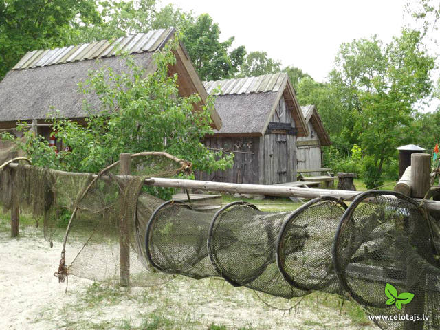
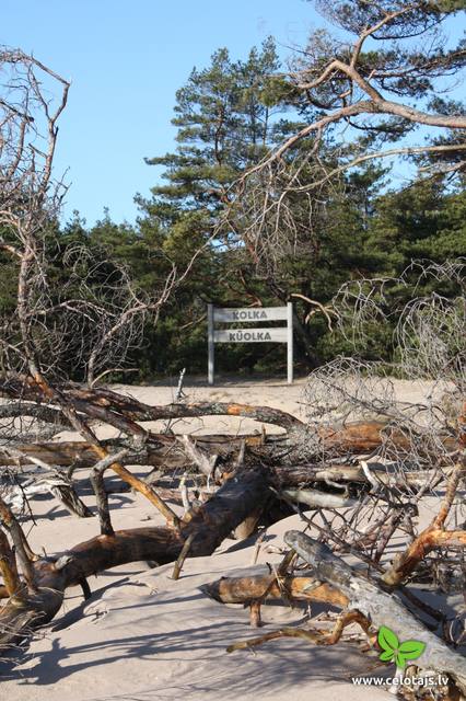
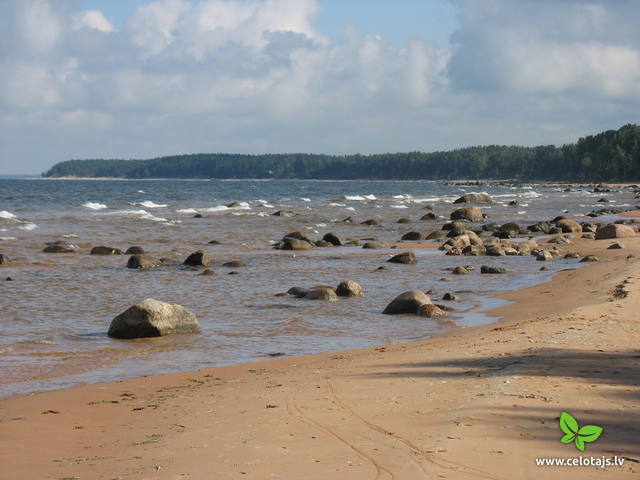
Kurzemes - Mazjūras piekraste: Jūrmala – KolkasragsMaršruts sākas populārākajā Latvijas kūrortā - Jūrmalā. Tas piemērots gājējiem, kam patīk iet gar jūras krastu, kur mijas gan ar savdabīgo piekrastes šarmu apvītie bijušie zvejniekciemi, gan mazskartas un vientuļas pludmales. Daudzviet ciemos darbojas mazas lauku kūpinātavas, kur ceļotājiem piedāvā žāvētas zivis. Maršruta galamērķis ir Kolkasrags, ko slavenais Latvijas jūrskolas dibinātājs Krišjānis Valdemārs uzskatīja par Eiropas centru. Kolkasrags kā viena no Baltijas jūras bīstamākajām kuģošanas vietām ir pazīstams jau no vikingu laikiem. Kolkasrags ir arī viena no Latvijas putnu vērošanas „top” – vietām. Maršruta informācija no Latvijas Lauku foruma
6-8
Pakalpojumi
6-8 Aktīvie sezonas mēneši |
 1 diena
|
Latvija
Daugavas krasti. Ceļo ar vilcienu un kājāmDaugava ir Latvijas lielākā upe un latviešu tautas likteņupe. Jau pēc leduslaikmeta beigām, pa Daugavas ieleju tagadējā Latvijas teritorijā „ieceļoja” pirmie augi un dzīvnieki, kuriem sekoja cilvēks. Šī iemesla dēļ Daugavas krasti ir viena no senākajām cilvēku dzīves vietām, kā arī augu sugām bagātākā valsts teritorija. Arī izcilu kultūras un vēstures pieminekļu lielais blīvums ir iemesls, kādēļ Daugavas krasti ir tūristu iecienīti. Rīgas – Jēkabpils posmā kā ērts pārvietošanās līdzeklis ir izmantojama Rīgas – Daugavpils dzelzceļa līnija. Tālāk norādītas dzelzceļa stacijas, kurās ir vērts izkāpt un veikt īsus – dažu stundu līdz pusdienas ilgus radiālus izgājienus ar atgriešanos stacijā. Maršruta informācija no Latvijas Lauku foruma
5-10
Pakalpojumi
5-10 Aktīvie sezonas mēneši |
 2 dienas
|
Latvija
Gaujas senleja: Sigulda - LīgatneMaršruts piemērots aktīviem un spēcīgiem gājējiem, kuri gan skatos, gan izjūtās vēlās veikt ceļojumu pa Baltijas varenākās upes ieleju. Tas sākas Siguldā, kas vēsturiski dēvēta par Vidzemes Šveici. Siguldas apkaimē paveras vieni no skaistākajiem Latvijas skatiem. Maršruts šķērso vairāku Gaujas pieteku dziļās gravas un atklāj upes krastus, kas Baltijas mērogā pazīstami ar varenajiem devona perioda smilšakmens atsegumiem. Līgatnes dabas takas ir vienīgā vieta Latvijā, kur mežam pietuvinātos dabiskos apstākļos – plašos voljēros dzīvo un apmeklētājiem apskatāmas mūsu mežiem raksturīgās dzīvnieku sugas. Dzīvniekus un to darbības pēdas var redzēt arī savvaļā, dodoties pa Gaujas nacionālā parka mežiem un takām. Maršruta informācija no Latvijas Lauku foruma
|
 2 dienas
Kopējie attālumi ar kājām 26 km
|
Latvija
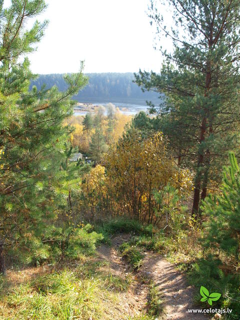
Slīteres nacionālais parks: Mazirbe - KolkaTeiksmainie Šlīteres Zilie kalni ir pazīstami jau no seniem laikiem, kad tajos „pirāti” kurināja viltus ugunskurus, lai jūrasbraucēji uzskrietu uz Kolkasraga sēkļiem. Mūsdienās Slīteres nacionālā parka piekrasti tēlaini sauc par Baltijas jūras brīvdabas ģeoloģijas muzeju, jo šeit apskatāms Baltijas ledus ezera senkrasts, Ancilus ezera krasta kāple un Litorīnas jūras kāpu veidojumi (kangari, vigas), kas uzskatāmi parāda Baltijas jūras attīstības vēsturi. Šo teritoriju vēsturiski apdzīvojuši lībieši, kuru zvejniekciemi ir nozīmīga vienas no pasaulē mazākās minoriotātes kultūrvidēm. Maršruts posmā no Kolkas līdz Mazirbei iet pa veco krasta ceļu, kas izlokas cauri lībiešu ciemiem. Slīteres nacionālais parks ir viena no augiem bagātākajām Latvijas teritorijām, bet Kolkasrags – viena no populārākajām putnu vērošanas vietām. Maršruta informācija no Latvijas Lauku foruma
5-9
Pakalpojumi
5-9 Aktīvie sezonas mēneši |
 4 dienas
Kopējie attālumi ar kājām 74 km
|
Latvija
Gar Vidzemes jūrmaluMaršruts ved pa vienu no Rīgas jūras līča daudzveidīgākajiem un skaistākajiem krastmalas posmiem. Tajā redzamas Randu pļavas, kuras augu daudzveidības dēļ dēvē par Latvijas brīvdabas „herbāriju”. Te staigājami krasta posmi, kas klāti ar dažāda lieluma laukakmeņiem. Netrūkst arī skaistas un smilšainas pludmales. Tūjas – Vitrupes posms ir vienīgā vieta, kur Latvijas jūras krastā atsedzas devona perioda smilšakmens klintis. Aiz katra nākamā zemesraga parādās aizvien savādāka ainava! Maršruta pēdējie divdesmit kilometri migrāciju laikā ir putnu vērotāju „paradīze”. Maršruts ietilpst Ziemeļvidzemes biosfēras rezervātā. Maršruta informācija no Latvijas Lauku foruma
5-9
Pakalpojumi
5-9 Aktīvie sezonas mēneši |
 2 dienas
Kopējie attālumi ar kājām 24 km
|
Latvija
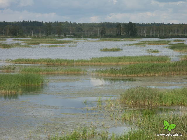
Seda - Sedas purvs - StrenčiMaršruts ar ļoti neparastiem skatiem! Seda ir vienīgā Latvijas pilsēta, kurai saglabājies pagājušā gadsimta vidus padomju laika plānojums ar centrālo laukumu un tam starveidā pieguļošām ielām. Sava veida eksotika ir dzīvojamo un sabiedrisko māju arhitektūras stils. Sedas purvs, kurā kūdra jau ir iegūta no Latvijas pirmās brīvvalsts laika, ir viena no lielākajām šāda veida industriālām - dabas teritorijām Latvijā un Baltijas valstīs. Agrāk izstrādātie kūdras lauki ir daļēji applūduši un aizauguši ar niedrēm, veidojot izcilu vidi ligzdojošajiem ūdensputniem un migrējošiem putniem, kas Sedas purvu izmanto kā atpūtas vietu. Kūdras ieguve turpinās arī mūsdienās un varbūt paveiksies ieraudzīt „mazo kūdras vilcieniņu”. Maršruta informācija no Latvijas Lauku foruma
6-8
Pakalpojumi
6-8 Aktīvie sezonas mēneši |
 2 dienas
Kopējie attālumi ar kājām 25 km
|
Latvija
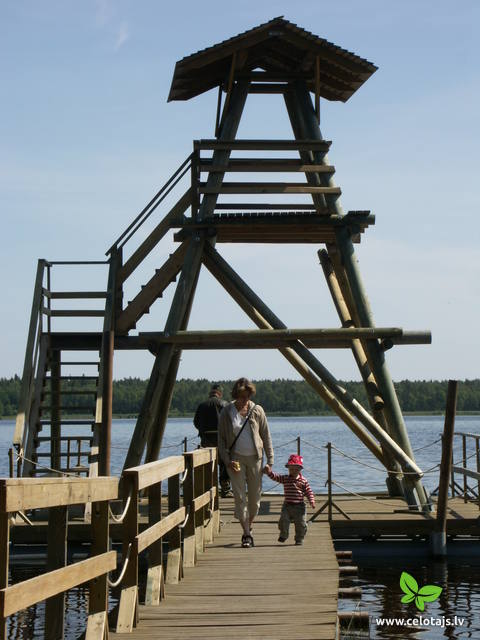
Ķemeru nacionālais parksĶemeru nacionālais parks (dibināts 1997. g.) veidots g.k. mitrāju – seklās Rīgas jūras līča piekrastes, aizaugošo piejūras ezeru, purvu, mitro mežu (dumbrāju u.c.) un palieņu pļavu - kā nozīmīgu daudzu augu (~ 25 % no Latvijas Sarkanā grāmatā ierakstītajām sugām) un dzīvnieku, īpaši - ligzdojošo un migrējošo putnu dzīves vietu aizsardzībai. Parka teritorijā atrodas viens no lielākajiem Latvijas purviem – Lielais Ķemeru tīrelis. Purvu masīvi ir nozīmīga sērūdeņu veidošanās un izplūdes vieta, kā arī ārstniecībā izmantojamo dūņu atrašanās vieta, kas bija kādreiz tik populārā Ķemeru kūrorta izveides pamats. Parkā apmeklētājus piesaista izglītojošas dabas takas, velo un kājāmgājēju maršruti, putnu vērošanas torņi. Maršruta informācija no Latvijas Lauku foruma
 45
6-8 45
6-8
Pakalpojumi
45km - Attālums no valsts galvaspilsētas
6-8 Aktīvie sezonas mēneši |


