
| No | Name | Description |
|---|---|---|
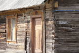 |
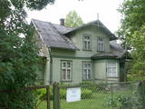
Vāldamõ – a residential building that is yellow and has natural roofing materials. It was built as a new farm at the beginning of the last century. Virgo is the next homestead to the North from Vāldamõ, and it was established as a new farm in the 1920s. The house (1930) features interesting wood carvings. Next to the North is Fīlmaņi, which has a building that appears antique, but was built in the early 20th century as a single roof. Silkalni is the homestead that we find if we turn to the right toward Pitrags at the crossroads. The yellow building was built around 1906 as a single room. Norpiedagi is to the South from Silkalni – a brown and larger house than the previous one. The home was built around 1906 as a one-room granary by the active Liv public activist and boat builder Diriķis Volganskis (1884-1968). His son, Edgars Valgamā, who was also a Liv cultural activist and worked as a pastor in Finland, was born here. Anduļi can be found at the aforementioned crossroads. This is one of the largest old farms in the village, and it is owned by the village elder. The history of the homestead was first recorded in 1680, when it was called Kūkiņi. The homestead includes a residential building (c. 1909), a threshing barn (1905), a granary (mid-19th century), and a smokehouse made of a boat that was cut in two. Under the part of the threshing barn which is on the back of the dune, there is the medieval, so-called Plague cemetery. Žoki is a homestead that is on the other side of the road from Anduļi. The building that is there now was built on the foundation of an older one. In the mid-19th century, Žoki was home to the first reading school for Liv children from the seashore villages of the Dundaga region. Liv Nika Polmanis (1823-1903) worked there as a teacher. Next to the North of Žoki is the Tilmači homestead, with several buildings that were built in the late 19th and early 20th century – a brown residential building, a stable and part of a granary. When the residential building was restored, the owner found a board reading "1825. Kurlyandskaya gubernya." The seven historical homesteads and buildings were at one time considered for listing on the UNESCO list of world heritage. |
|
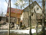 |
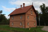
The Narūta River which flows out of Lake Ežezers is approximately 1 km long and ends at the small Obiteļi windmill lake. On the right bank of the river is a windmill that was built around 1900. Today the site has the Obiteļa leisure centre with a sauna and banquet facilities. |
|
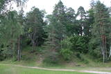 |
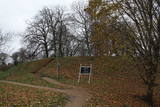
Atrodas 0,5 km ziemeļaustrumos no Dzērbenes baznīcas, ceļa otrajā pusē. Vizuāli izteiksmīgs pilskalns ar 50 x 50 m lielu plakumu, kura kultūrslānī atrastas vēlā dzelzs laikmeta apmetnes atliekas. Pilskalna rietumu nogāzē ir izveidots ceļš, pa kuru nonāksim līdz tā plakumam ar estrādi. |
|
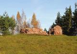 |
Swedish scanst (Kuce Hill, Jumprava Hill). Medieval fortification. The monument of national meaning
is located in the village Stari 450 m from Atspuki mill, 70 mto the Southeast from the ruins of Jumpravmuiža.
The territory is 0,7 – 1 m deep outside and 1 – 1,5 m high inside. The new road to the ruins of Jumpravmuiža
leads through the West side of the fortification.
|
|
 |
Vijciema čiekurkalte savu darbību uzsāka 1895. g. pēc plašiem apkārtnes meža ugunsgrēkiem. Šobrīd tā ir vecākā Latvijā un viena no vecākajām Eiropas čiekuru kaltēm. Pēc ceturtdaļgadsimta dīkstāves to atjaunoja 1992. g. Vienreizējais kultūrvēstures piemineklis ir saglabāts pilnīgā darba kārtībā. Ēkā atrodas 19. gs. beigās ražotā autentiskā iekārta un aprīkojums. Arī mūsdienās to izmanto čiekuru žāvēšanai. Ekskursijas laikā apmeklētāji var iepazīties pilnu čiekuru (g.k. – priedes) apstrādes ciklu. Ziemā, kad ir īstais čiekuru žāvēšanas laiks, te demonstrē kaltēšanas procesu. Vijciema čiekurkalte ir iekļauta Eiropas kultūras mantojuma objektu sarakstā. |
|
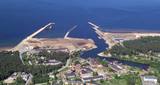 |
In the 19th century at the seaside of Skulte, a small village formed, which was inhabited by fishermen. The name “Zvejniekciems” (Fishermen’s village) arose from the population's main activity. In 1967 the Skulte part of Zvejniekciems was added to the Saulkrasti township. Nowadays Zvejniekciems is the home of Skulte Port, and the rocky beach of Zvejniekciems is located between the port and Saulkrasti Beach, while the village itself can be proud of the creative heritage left by the architect Marta Staņa (1913–1972). |
|
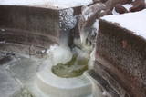 |
Built in the turn of the19th to 20th century. Next to it-on the right bank of the river Vēršupīte, there is located one of the most popular Latvian sulphur water springs, called "Small lizard". The spring runs out from a stone-designed lizard sculptured in 1949 (Sculptor J. Bajārs). Its water is healthy for using both internally and externally. Not far from the pavilion there can be found Jānis Lībietis alley sign. J. Lībietis worked in the position of a director for the sulphur water spring authority of Kemeri from 1928 to 1944. |
|
 |
The historic stone, on which there is carved over 200 years old boundary-mark, sets the border between the Duchy of Courland and the Russian province. Nowadays, it sets the Babīte and Jelgava district boundary. The stone lies to the East of Kalnciems–Peat road (the south of the swamp Labais purvs) at the edge of a forest firebreak and it can be hard to find. To this end, the description of the road map may help: around 400 m south of the car parking lot at Lily Lake from Kalnciems-Peat road to the right (in the east) turns a forest road which leads down from hills Krāču kalni. It should be around 170 m to go until it abruptly turns to the right (to the southeast). Then you must go in this direction until after ~ 0.5 km to turn to the northeast where after further ~ 0.4 km of the current forest road intersection turn to the north. After ~ 0.4 km turn right (to the east) on a big firebreak, on the left (the north) side of which behind the drainage ditch during the non-leaf period there can be seen a rounded stone. Due to the poor condition of roads, the stone can be reached only on foot. |
|
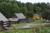 |
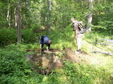
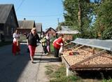
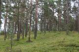
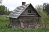
Grūti iedomāties, ka vēl joprojām Eiropā ir apdzīvotas vietas, kuru sasniegšanai ir labu laika sprīdi jābrauc pa neapdzīvotu mežu ieskautu smilšainu ceļu, kur tikai paretam var redzēt kādu sēņotāju vai ogotāju! Tāpat kā Zervinos ciemam, arī šim ir piešķirts kultūras mantojuma pieminekļa statuss, jo Linežeris ir viens no dažiem nacionālā parka etnogrāfiskajiem ciemiem. Linežerī ir aplūkojamas 19. – 20. gs. mijā celtās ēkas un apskatāms tā laika ciema plānojums. Šejieniešu tāpat kā citu dzūku galvenā nodarbošanās bija mežistrāde un meža velšu vākšana. Nelielā mērā – arī lauksaimniecība. Apceļojot nacionālā parka etnogrāfiskos ciemus, rodas pamatots jautājums: „Ar ko mūsdienās te nodarbojas cilvēki. Kā viņi spēj dzīvot tik nomaļā vietā”? Jāatzīst, ka lielākā daļa te ierodas tikai vasaras laikā. Neskatoties uz to, etnogrāfiskie ciemi ir ļoti sakopti un joprojām „dzīvi”! |
|
 |
The remnants of the Vardīte sulphurous
spring – not easy to find, but the location is
between the Forest House and the Ķemeri
Hotel.
|
|
 |
Kolkja, Kasepää and Varnja are another example of one-street villages of Old Believers who fled to Estonia from Russia in the 17th and 18th centuries. |
|
 |
This ancient Courlandian castle hill has remnants of an ancient city. Historical sources indicate that in 1263, the Courlandians handed the castle over to the Livonian Order without a battle and that the castle was then burned down. The name of the place, Skābaržkalns, has to do with the name of the city, because hornbeam trees in the area were once known as grobi. |
|
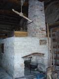 |
In Metsanurme Village Centre you can see restored old threshing barn, limestone barn oven and few tools that were used ages ago. You could be also interested in seeing an outdoor exhibition which focuses on historical agricultural tools. All of this is made to look interesting to not only locals but also visitors. |
|
 |
This is the one street in Ķemeri where the towns' wooden buildings have been preserved to the greatest degree. Turning onto Durbes Street from Karogu Street, you will find the Miervaldis Ķemers Museum, which is focused on the well known Latvian cultural activist, pastor and painter (1902-1980). The museum is at Durbes Street 21. |
|
 |
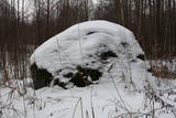
This may be an ancient cult object, and today it is a little hill in the dunes that is a bit larger than other local hills. It is said that a church once sank into the dune. This tale suggests that there was a Christian or pagan prayer place here at one time. (Source: Roja TIC) |
|
 |
To the East of the Ezermuiža-Dūmele road you will find the bed of the ancient Lake Dieviņezers. It was one of the largest lakes in Kurzeme in the past, being 7.5 km long and 1.6 km wide. A canal was dug in 1838 (Melnsilupe River today), and the water from the lake was siphoned to the sea so as to create fertile farmland. Residents of Ezermuiža have been involved in forestry work since the age when barons ruled the land. Dūmele is connected to Košrags by a lonely forest road that is known as the Bottom Road. A bike route runs down it. The Ziedkalni weekend house is in Dūmele. The "Ziedkalni" homestead in Dūmele offers spa services, cod fishing and accommodations. |
|
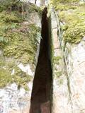 |
The Vējupīte ravine is meant for those who are not afraid of long and steep wooden stairs of the type that lead you up and down the ravine. From the Līvkalns guesthouse, you can climb the stairs downward, where you will find a shallow (3.6 m) but high (6.1 m) cave – the Pēters Cave. It is something of a gap or a niche. Another 10 minutes or so downstream (toward the Gauja) will lead you to the deep Pūces ravine and its Kraukļupīte River. The Satezele castle hill is at the confluence of the two rivers (90 x 75 m). A wooden castle was there during the feudal era in the early 13th century. Its main entrance was on the western side of the castle hill. You can get to the hill from the depths of the ravine via a wooden staircase. The Kraukļi ravine, in turn, is accessible if you climb down the same stairs and continue on your way toward the Gauja. The ravine is found on the left bank of the Vējupīte, and its sandstone walls are up to 11 m high. The Kraukļi cave, which is 5.2 m deep, is on the wall. Another 10-15 minutes (crossing the Vējupīte on a wooden bridge), and you will find another staircase leading you to Paradīze Hill (see the description above). |
|
 |
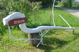
Divas mazas apdzīvotas vietas nacionālā parka dienvidrietumu daļā. No kādreiz piecām Kolski ciema saimniecībām līdz mūsdienām ir saglabājusies tikai viena. Kolski iedzīvotājus līdzīgi kā citviet Baltijas valstīs pēc 2. pasaules kara deportēja uz Sibīriju. Kolski apkārtnē redzamie mājdzīvnieki „apsaimnieko” šejienes pļavas, neļaujot tām aizaugt ar mežu. Tādējādi tiek uzturēta apkaimes vēsturiskā ainava. 3 km dienvidrietumos meklējams Kobasāres ciems. Tā nosaukums (koopa no igauņu valodas nozīmē ala, saar – sala) atgādina par Ziemeļu kara notikumiem, kura laikā cilvēki slēpušies pašu raktās alās. Kobasārē un tam blakus esošajā Apjas (Apja) ciemā var izbaudīt patiesi 21. gadsimtam nepierastas lauku ainavas. |
|
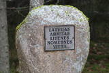 |
Name of Litene is associated with one of the most tragic pages of Latvian history. In twenties and thirties of the 20th century a Latvian Army summer camp was located nearby, where in the summer of 1941 Latvian officers faced the communist terror: Nearly five hundred officers of Latvian army were sent to Norilsk in Siberia, part of them was shot and secretly buried in the nearby forest. At the end of the summer of 1941 about 300 civilians, mostly Jews, were shot there by the army of Nazi Germany. Today, honouring the memory of people killed, memorial and memorial sites are created. |
|
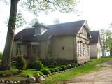 |
The cosy land road along the sea is 1 km long, and it offers a look at the wonderful aspects of the village. To the right are rocks from the sea, as well as miniature flower gardens on the seashore with tempting benches and overturned boats. On the side of the shore is the Kaltene library, which is more than 100 years ago. It was initially a summer home for Baron Nolken, and it was built in 1899. Later it was rebuilt several times and took on new roles. An elementary school was installed here in 1926, after which it became a club and then, in 1992, a primary school once again. The path runs along beautiful seashore homesteads, among which one can find the former homes of old fishermen and ship builders such as Burliņi. At one time, the Žulnieki portage at Smilgas was the site of the kiln of blacksmith Pēteris Valdemārs. He was the main blacksmith for ships between Kaltene and Upesgrīve. (Source: Roja TIC) |
|
